@arcgis/core 5.1.0-next.18 → 5.1.0-next.19
This diff represents the content of publicly available package versions that have been released to one of the supported registries. The information contained in this diff is provided for informational purposes only and reflects changes between package versions as they appear in their respective public registries.
- package/Camera.d.ts +1 -1
- package/Ground.d.ts +7 -7
- package/PopupTemplate.d.ts +6 -6
- package/WebScene.d.ts +1 -1
- package/analysis/AreaMeasurementAnalysis.d.ts +1 -1
- package/analysis/DirectLineMeasurementAnalysis.d.ts +1 -1
- package/analysis/LengthDimension.d.ts +4 -4
- package/analysis/ShadowCastAnalysis.d.ts +3 -3
- package/analysis/SliceAnalysis.d.ts +1 -1
- package/analysis/SlicePlane.d.ts +1 -1
- package/analysis/VolumeMeasurement/VolumeMeasurementCutFillOptions.d.ts +1 -1
- package/analysis/VolumeMeasurementAnalysis.d.ts +1 -1
- package/applications/Components/applySetUtils.d.ts +1 -1
- package/applications/WebEditor/geometryUtils.d.ts +26 -0
- package/applications/WebEditor/geometryUtils.js +2 -0
- package/assets/esri/core/workers/RemoteClient.js +1 -1
- package/assets/esri/core/workers/chunks/045e4e520d6dffe06ba7.js +1 -0
- package/assets/esri/core/workers/chunks/05d6cd51ca970705e46a.js +1 -0
- package/assets/esri/core/workers/chunks/{fd125618f513bc2f5206.js → 08d73543c713984f6ecf.js} +1 -1
- package/assets/esri/core/workers/chunks/{982e709d2cef971ecd82.js → 0d9d33f29124d464a4cb.js} +1 -1
- package/assets/esri/core/workers/chunks/{07317f6b57c1314db442.js → 0e1d559d05229ef92e35.js} +1 -1
- package/assets/esri/core/workers/chunks/{2762149a922275136171.js → 112227b862b935123ddf.js} +2 -2
- package/assets/esri/core/workers/chunks/128cdb4a02549abc68b5.js +1 -0
- package/assets/esri/core/workers/chunks/1336f685bae5f1251558.js +1 -0
- package/assets/esri/core/workers/chunks/{b71e4f48377fefe2537d.js → 15d46482ec096e3ce161.js} +1 -1
- package/assets/esri/core/workers/chunks/1794db88a2006711eff3.js +1 -0
- package/assets/esri/core/workers/chunks/{a327f36561f093dc0fab.js → 19fcc74d34cbbaa56a41.js} +1 -1
- package/assets/esri/core/workers/chunks/{d0d1378e714ff0e43e26.js → 1cfa8d404d42b9eccf78.js} +1 -1
- package/assets/esri/core/workers/chunks/1e916e552ce7d53692d2.js +1 -0
- package/assets/esri/core/workers/chunks/2011da6dfc4bb89829c6.js +1 -0
- package/assets/esri/core/workers/chunks/{1e29a114c1cfe21121c4.js → 203ef5459fc5dde12851.js} +1 -1
- package/assets/esri/core/workers/chunks/215c54520d0da638fe57.js +1 -0
- package/assets/esri/core/workers/chunks/22045f85e503ae0ec8f4.js +1 -0
- package/assets/esri/core/workers/chunks/{78fc7ef00cc4931ef47d.js → 2351b713ba3d05de0728.js} +1 -1
- package/assets/esri/core/workers/chunks/{0a4ebb5dca630a4ab0dd.js → 236f8137ae505c8f0764.js} +1 -1
- package/assets/esri/core/workers/chunks/249630af2fb01257eb75.js +1 -0
- package/assets/esri/core/workers/chunks/{1f30558e3ad6ac68bdb8.js → 25d34552bfb255af9467.js} +1 -1
- package/assets/esri/core/workers/chunks/{7cd4280d24b24045bd7e.js → 27e14277128446e76b45.js} +1 -1
- package/assets/esri/core/workers/chunks/3214763f268622f09986.js +1 -0
- package/assets/esri/core/workers/chunks/32a1ccc145c9f6091e13.js +1 -0
- package/assets/esri/core/workers/chunks/34691b147318b2cfdd45.js +1 -0
- package/assets/esri/core/workers/chunks/{18c05353d6d8950d1491.js → 36215b2c0b1020743458.js} +1 -1
- package/assets/esri/core/workers/chunks/3d3b1ce112be6ea31d93.js +1 -0
- package/assets/esri/core/workers/chunks/{2badadf8032e166b34ec.js → 3f3c63420644f9522ab1.js} +1 -1
- package/assets/esri/core/workers/chunks/41108f58f0f439ebba3f.js +1 -0
- package/assets/esri/core/workers/chunks/{bc9997d15ec0a86793c6.js → 415957a42e45eb21aa84.js} +1 -1
- package/assets/esri/core/workers/chunks/43c797bfc2191b51875b.js +1 -0
- package/assets/esri/core/workers/chunks/460a82f3e4838b13e3b4.js +1 -0
- package/assets/esri/core/workers/chunks/4ad6f80488aa218b95e3.js +1 -0
- package/assets/esri/core/workers/chunks/4e9863a11d09900baf30.js +1 -0
- package/assets/esri/core/workers/chunks/4fe210314813ea1f7a26.js +1 -0
- package/assets/esri/core/workers/chunks/5028de543cc1b8e60e65.js +1 -0
- package/assets/esri/core/workers/chunks/52705ccbb452a3edb064.js +1 -0
- package/assets/esri/core/workers/chunks/{17b39b88547968048113.js → 531c55f3b8e708ccf767.js} +1 -1
- package/assets/esri/core/workers/chunks/{72acfb74fd9ab9bae923.js → 53e348f5585fa8c53fe8.js} +2 -2
- package/assets/esri/core/workers/chunks/54c545f44b7ce21fb604.js +1 -0
- package/assets/esri/core/workers/chunks/558e9fed2e58cbbf9947.js +1 -0
- package/assets/esri/core/workers/chunks/{b50d2d3379654de1f2f3.js → 58134617fb7530836b81.js} +1 -1
- package/assets/esri/core/workers/chunks/58c4be467a922fe37f01.js +1 -0
- package/assets/esri/core/workers/chunks/{ec4e2f18453e1cb68fed.js → 5f10f39835cb40179000.js} +1 -1
- package/assets/esri/core/workers/chunks/{7b1964255722e756eba3.js → 5f9eeab833a6c08c76c4.js} +1 -1
- package/assets/esri/core/workers/chunks/651b46aeabf22ff53a38.js +1 -0
- package/assets/esri/core/workers/chunks/65f86594c42ff82095fe.js +1 -0
- package/assets/esri/core/workers/chunks/{90316fb569389d48920f.js → 666f201d222c50ab8428.js} +1 -1
- package/assets/esri/core/workers/chunks/677f5e444ff588ab670f.js +1 -0
- package/assets/esri/core/workers/chunks/{323f6077a659416c4cee.js → 6a9a96aa811c1d3b6edb.js} +1 -1
- package/assets/esri/core/workers/chunks/6bf7d8de86b9eb76f920.js +1 -0
- package/assets/esri/core/workers/chunks/6c0b7890c8eec7febe28.js +1 -0
- package/assets/esri/core/workers/chunks/{25c189e894927099c239.js → 6c85396c90941a042c33.js} +1 -1
- package/assets/esri/core/workers/chunks/{18b0776aef1536867ab8.js → 6f337c3ccd84d90a35e5.js} +1 -1
- package/assets/esri/core/workers/chunks/711bec78dc00fad0f78d.js +1 -0
- package/assets/esri/core/workers/chunks/7382c9882525101eddad.js +1 -0
- package/assets/esri/core/workers/chunks/778ab9e4c3928b0d7d74.js +1 -0
- package/assets/esri/core/workers/chunks/{a3e8b7185d63a0f85931.js → 79c69ae86a1f4a56f7c7.js} +1 -1
- package/assets/esri/core/workers/chunks/{0420fb4b3592f8a26b1f.js → 7d2b1e5402a88b6bee85.js} +1 -1
- package/assets/esri/core/workers/chunks/7ec83fc059325e207825.js +1 -0
- package/assets/esri/core/workers/chunks/7f385e9c88df3395e678.js +1 -0
- package/assets/esri/core/workers/chunks/{66ed527cd8ad11d008be.js → 80d51d58db09b9f96cb5.js} +1 -1
- package/assets/esri/core/workers/chunks/81a45d7e9dadf678b584.js +1 -0
- package/assets/esri/core/workers/chunks/81c758bdc07ed9d9a132.js +1 -0
- package/assets/esri/core/workers/chunks/{8670d9d11950f3c61b79.js → 83711695e16912e9b9c5.js} +1 -1
- package/assets/esri/core/workers/chunks/8c3bf66f8543cedc72ef.js +1 -0
- package/assets/esri/core/workers/chunks/8cade3af17a8bb6d4e37.js +1 -0
- package/assets/esri/core/workers/chunks/920d6330df72e2f01d19.js +1 -0
- package/assets/esri/core/workers/chunks/9dc7abca1d1eb9ba5b58.js +1 -0
- package/assets/esri/core/workers/chunks/9e054c264b17f04b7efa.js +1 -0
- package/assets/esri/core/workers/chunks/a143a6f8e2f21548b244.js +1 -0
- package/assets/esri/core/workers/chunks/a48a6232fa33084cb686.js +1 -0
- package/assets/esri/core/workers/chunks/a4947d5d2fa6b7bd399b.js +1 -0
- package/assets/esri/core/workers/chunks/a49f1172b17c14527acf.js +1 -0
- package/assets/esri/core/workers/chunks/{6af14a0217077d9ab47f.js → aaf3ed508d30ed583915.js} +1 -1
- package/assets/esri/core/workers/chunks/{ab9156be67332338bbe4.js → aceec85ce64a3e6d8761.js} +1 -1
- package/assets/esri/core/workers/chunks/b10b3eb8c2ed9be14ab2.js +1 -0
- package/assets/esri/core/workers/chunks/b315b3771d0d19681aa5.js +1 -0
- package/assets/esri/core/workers/chunks/{91858b02da40ff251ab2.js → b397a9f87082705301a4.js} +2 -2
- package/assets/esri/core/workers/chunks/b40e4ed067da65c3d7ce.js +1 -0
- package/assets/esri/core/workers/chunks/b4b16914950792c46bd3.js +1 -0
- package/assets/esri/core/workers/chunks/{360b3499e2a671c309ce.js → b6969a42602517a6ef1c.js} +1 -1
- package/assets/esri/core/workers/chunks/baad696d84ab78b3d00e.js +2 -0
- package/assets/esri/core/workers/chunks/{2e7d4a437717606bc39c.js → bc2dcbdc414d157ab727.js} +1 -1
- package/assets/esri/core/workers/chunks/{1aa2187597f7c4adb67f.js → bcb254cb7297fec88679.js} +1 -1
- package/assets/esri/core/workers/chunks/{2d1a772abd730b61854f.js → bd2125e0a68378533641.js} +1 -1
- package/assets/esri/core/workers/chunks/{6bd910e0480451a8d6aa.js → bde2c3199f667b63dbe8.js} +1 -1
- package/assets/esri/core/workers/chunks/bf595eb10f99b8a96baa.js +1 -0
- package/assets/esri/core/workers/chunks/c0b6706f86665cec85f8.js +1 -0
- package/assets/esri/core/workers/chunks/{12fd2e26e949d90abfbd.js → c3c6d337ff53e5d921e8.js} +1 -1
- package/assets/esri/core/workers/chunks/c461c19e4fdbdd2e94d4.js +1 -0
- package/assets/esri/core/workers/chunks/{4214f46bee613dea72f3.js → c66aa57b6360963bd938.js} +1 -1
- package/assets/esri/core/workers/chunks/c873ac660e7d5dc88781.js +1 -0
- package/assets/esri/core/workers/chunks/c99f36159b5ed6f9267e.js +1 -0
- package/assets/esri/core/workers/chunks/cb5f4820277f3fc7ff2f.js +1 -0
- package/assets/esri/core/workers/chunks/cbcb3530375e280bfeac.js +1 -0
- package/assets/esri/core/workers/chunks/cf4202ad468501ef24cf.js +1 -0
- package/assets/esri/core/workers/chunks/d03d50f3247327257d8b.js +1 -0
- package/assets/esri/core/workers/chunks/{a5af20f3d484d2d3bafe.js → d2017b0b27b9e4ada922.js} +1 -1
- package/assets/esri/core/workers/chunks/d2d9c1f32a75befe168b.js +1 -0
- package/assets/esri/core/workers/chunks/{5c12a9b0db317620dce2.js → d39f5d57f7e35c00ca16.js} +1 -1
- package/assets/esri/core/workers/chunks/d5b4487a983921572e58.js +1 -0
- package/assets/esri/core/workers/chunks/d78b2f85ec9212a973e8.js +1 -0
- package/assets/esri/core/workers/chunks/d9dc8d9fc8ab2706f96b.js +1 -0
- package/assets/esri/core/workers/chunks/{09cf8aed89a1ea1f8b28.js → da42da04a9df651b06cc.js} +1 -1
- package/assets/esri/core/workers/chunks/{a82587f69c4bbcac7e0b.js → dc7df2072c0ebed5602c.js} +1 -1
- package/assets/esri/core/workers/chunks/dd24cddc406f610d2483.js +1 -0
- package/assets/esri/core/workers/chunks/dd3789e71270a4640551.js +1 -0
- package/assets/esri/core/workers/chunks/de5719ef663224860af5.js +1 -0
- package/assets/esri/core/workers/chunks/de6438fdbe38d32c4ad5.js +1 -0
- package/assets/esri/core/workers/chunks/ded71a656e2626a411f9.js +1 -0
- package/assets/esri/core/workers/chunks/df1fa0f7e8f7e2bcc2e6.js +1 -0
- package/assets/esri/core/workers/chunks/{b705f837caa76cee81fc.js → e09722903e63f6cc2540.js} +1 -1
- package/assets/esri/core/workers/chunks/e2e03622936d2b35afc0.js +1 -0
- package/assets/esri/core/workers/chunks/e33f5780fb45ac7ca889.js +1 -0
- package/assets/esri/core/workers/chunks/{eb9e913fe0dfcc71cf92.js → e4611ebd7dba7692a914.js} +1 -1
- package/assets/esri/core/workers/chunks/e52793690dff1a199647.js +1 -0
- package/assets/esri/core/workers/chunks/{c13efb74aa4602f6a1ee.js → e56a10a475ce128b5fce.js} +1 -1
- package/assets/esri/core/workers/chunks/{9531f17cecd50431cce2.js → e8ae71e482b8d5f54a72.js} +1 -1
- package/assets/esri/core/workers/chunks/ea633a6a3b9ea8ce965d.js +1 -0
- package/assets/esri/core/workers/chunks/eae1c098c16e2faaf90d.js +1 -0
- package/assets/esri/core/workers/chunks/{f7e25a85a79c4e3c1c9f.js → ec63c0fa21cd3c872633.js} +1 -1
- package/assets/esri/core/workers/chunks/ece363681bb09072f379.js +1 -0
- package/assets/esri/core/workers/chunks/edaae0fc63d16b0f675d.js +2 -0
- package/assets/esri/core/workers/chunks/{8650fbe1db55b7280c00.js → ef4237dc7b67c9039826.js} +1 -1
- package/assets/esri/core/workers/chunks/ef9106ee818ec732b670.js +1 -0
- package/assets/esri/core/workers/chunks/f121a0bf33c03abfa0b6.js +1 -0
- package/assets/esri/core/workers/chunks/{a2f38e86acf45272dbc2.js → f7506c9d57b2ae0c5fd3.js} +1 -1
- package/assets/esri/core/workers/chunks/fab7e3e07d700d7bb651.js +1 -0
- package/assets/esri/core/workers/chunks/fcc8d0b60f7c2397e550.js +1 -0
- package/assets/esri/core/workers/chunks/fe5aec7e2da4465422b4.js +1 -0
- package/assets/esri/themes/base/widgets/_BasemapGallery.scss +1 -0
- package/assets/esri/themes/base/widgets/_Editor.scss +1 -0
- package/assets/esri/themes/dark/main.css +1 -1
- package/assets/esri/themes/light/main.css +1 -1
- package/assets/esri/themes/light/view.css +1 -1
- package/chunks/Envelope.js +1 -1
- package/chunks/GeodeticDistanceCalculator-Ce-woMPw.js +1 -1
- package/chunks/GeodeticUtils.js +1 -1
- package/chunks/Geometry.js +1 -1
- package/chunks/MultiPathImpl.js +1 -1
- package/chunks/OperatorGeodesicBuffer.js +1 -1
- package/chunks/OperatorGeodeticArea.js +1 -1
- package/chunks/OperatorGeodeticDensifyByLength.js +1 -1
- package/chunks/OperatorGeodeticLength.js +1 -1
- package/chunks/OperatorIntegrate.js +2 -0
- package/chunks/OperatorMultiPartToSinglePart.js +1 -1
- package/chunks/OperatorProximityGeodesic.js +1 -1
- package/chunks/OperatorShapePreservingLength.js +1 -1
- package/chunks/OperatorShapePreservingProject.js +1 -1
- package/chunks/Point2D.js +1 -1
- package/chunks/SpatialReference.js +1 -1
- package/chunks/containsOperator.js +1 -1
- package/chunks/disjointOperator.js +1 -1
- package/chunks/relateOperator.js +1 -1
- package/config.js +1 -1
- package/core/has.js +1 -1
- package/editing/sharedTemplates/SharedTemplateMetadata.d.ts +0 -31
- package/{layers/graphics/editingSupport.d.ts → editing/types.d.ts} +8 -8
- package/editing/types.js +2 -0
- package/effects/FocusAreas.d.ts +1 -1
- package/form/elements/FieldElement.d.ts +1 -1
- package/form/elements/GroupElement.d.ts +1 -1
- package/form/elements/TextElement.d.ts +1 -1
- package/form/elements/inputs/ComboBoxInput.d.ts +1 -1
- package/form/elements/inputs/RadioButtonsInput.d.ts +1 -1
- package/form/elements/inputs/SwitchInput.d.ts +1 -1
- package/geometry/Mesh.d.ts +7 -7
- package/geometry/operators/alphaShapeOperator.d.ts +1 -1
- package/geometry/operators/areaOperator.d.ts +1 -1
- package/geometry/operators/bufferOperator.d.ts +1 -1
- package/geometry/operators/centroidOperator.d.ts +1 -1
- package/geometry/operators/clipOperator.d.ts +1 -1
- package/geometry/operators/containsOperator.d.ts +1 -1
- package/geometry/operators/convexHullOperator.d.ts +1 -1
- package/geometry/operators/crossesOperator.d.ts +1 -1
- package/geometry/operators/cutOperator.d.ts +1 -1
- package/geometry/operators/densifyOperator.d.ts +1 -1
- package/geometry/operators/differenceOperator.d.ts +1 -1
- package/geometry/operators/disjointOperator.d.ts +1 -1
- package/geometry/operators/distanceOperator.d.ts +1 -1
- package/geometry/operators/extendOperator.js +1 -1
- package/geometry/operators/generalizeOperator.d.ts +1 -1
- package/geometry/operators/geodesicProximityOperator.d.ts +1 -1
- package/geometry/operators/geodeticDistanceOperator.d.ts +1 -1
- package/geometry/operators/geodeticUtilsOperator.d.ts +2 -2
- package/geometry/operators/graphicBufferOperator.d.ts +1 -1
- package/geometry/operators/gx/operatorAlphaShape.js +1 -1
- package/geometry/operators/gx/operatorAutoComplete.js +1 -1
- package/geometry/operators/gx/operatorConvexHull.js +1 -1
- package/geometry/operators/gx/operatorIntegrate.js +1 -1
- package/geometry/operators/gx/operatorIntersection.js +1 -1
- package/geometry/operators/gx/operatorLabelPoint.js +1 -1
- package/geometry/operators/gx/operatorMinimumBoundingCircle.js +1 -1
- package/geometry/operators/gx/operatorPolygonOverlay.js +1 -1
- package/geometry/operators/gx/operatorSymmetricDifference.js +1 -1
- package/geometry/operators/intersectionOperator.d.ts +1 -1
- package/geometry/operators/intersectsOperator.d.ts +1 -1
- package/geometry/operators/isNearOperator.d.ts +1 -1
- package/geometry/operators/json/containsOperator.js +1 -1
- package/geometry/operators/json/disjointOperator.js +1 -1
- package/geometry/operators/lengthOperator.d.ts +1 -1
- package/geometry/operators/locateBetweenOperator.d.ts +1 -1
- package/geometry/operators/multiPartToSinglePartOperator.d.ts +1 -1
- package/geometry/operators/offsetOperator.d.ts +5 -5
- package/geometry/operators/overlapsOperator.d.ts +1 -1
- package/geometry/operators/proximityOperator.d.ts +1 -1
- package/geometry/operators/reshapeOperator.js +1 -1
- package/geometry/operators/simplifyOGCOperator.d.ts +1 -1
- package/geometry/operators/simplifyOperator.d.ts +1 -1
- package/geometry/operators/support/GeographicTransformation.d.ts +6 -4
- package/geometry/operators/support/GeographicTransformation.js +1 -1
- package/geometry/operators/support/GeographicTransformationStep.d.ts +5 -3
- package/geometry/operators/support/GeographicTransformationStep.js +1 -1
- package/geometry/operators/support/Transformation.d.ts +6 -6
- package/geometry/operators/support/jsonConverter.js +1 -1
- package/geometry/operators/support/projectionTransformation.js +1 -1
- package/geometry/operators/symmetricDifferenceOperator.d.ts +1 -1
- package/geometry/operators/touchesOperator.d.ts +1 -1
- package/geometry/operators/unionOperator.d.ts +1 -1
- package/geometry/operators/withinOperator.d.ts +1 -1
- package/geometry/support/MeshMaterialMetallicRoughness.d.ts +1 -1
- package/geometry/support/zscale.js +1 -1
- package/graphic/KnowledgeGraphGraphicOrigin.d.ts +0 -1
- package/graphic/LinkChartGraphicOrigin.js +1 -1
- package/interfaces.d.ts +60 -60
- package/kernel.js +1 -1
- package/layers/BuildingSceneLayer.d.ts +4 -4
- package/layers/CSVLayer.d.ts +319 -542
- package/layers/CSVLayer.js +1 -1
- package/layers/CatalogLayer.d.ts +2 -2
- package/layers/ElevationLayer.d.ts +1 -1
- package/layers/FeatureLayer.d.ts +15 -15
- package/layers/FeatureLayer.js +1 -1
- package/layers/GeoJSONLayer.d.ts +6 -6
- package/layers/GeoRSSLayer.d.ts +1 -1
- package/layers/GraphicsLayer.d.ts +2 -2
- package/layers/ImageryLayer.d.ts +3 -3
- package/layers/ImageryTileLayer.d.ts +2 -2
- package/layers/IntegratedMesh3DTilesLayer.d.ts +6 -6
- package/layers/IntegratedMeshLayer.d.ts +7 -7
- package/layers/MapImageLayer.d.ts +1 -1
- package/layers/MediaLayer.d.ts +1 -1
- package/layers/OGCFeatureLayer.d.ts +2 -2
- package/layers/OrientedImageryLayer.d.ts +6 -6
- package/layers/OrientedImageryLayer.js +1 -1
- package/layers/PointCloudLayer.d.ts +1 -1
- package/layers/SceneLayer.d.ts +7 -7
- package/layers/StreamLayer.d.ts +2 -2
- package/layers/SubtypeGroupLayer.d.ts +5 -5
- package/layers/VectorTileLayer.d.ts +2 -2
- package/layers/VideoLayer.d.ts +1 -1
- package/layers/VoxelLayer.d.ts +8 -8
- package/layers/WFSLayer.d.ts +6 -6
- package/layers/catalog/CatalogFootprintLayer.d.ts +1 -1
- package/layers/graphics/applyEditsUtils.js +1 -1
- package/layers/graphics/data/QueryEngineCapabilities.js +1 -1
- package/layers/graphics/data/QueryEngineResult.js +1 -1
- package/layers/graphics/editingSupport.js +1 -1
- package/layers/graphics/sources/FeatureLayerSource.js +1 -1
- package/layers/graphics/sources/OGCFeatureSource.js +1 -1
- package/layers/graphics/sources/support/CSVSourceWorker.js +1 -1
- package/layers/graphics/sources/support/ParquetSourceWorker.js +1 -1
- package/layers/graphics/sources/support/QueryTask.js +1 -1
- package/layers/mixins/ArcGISImageService.js +1 -1
- package/layers/mixins/BlendLayer.d.ts +6 -6
- package/layers/mixins/EditBusLayer.d.ts +1 -1
- package/layers/orientedImagery/core/ExposurePoint.js +1 -1
- package/layers/orientedImagery/transformations/utils.js +1 -1
- package/layers/pointCloudFilters/PointCloudReturnFilter.d.ts +1 -1
- package/layers/pointCloudFilters/PointCloudValueFilter.d.ts +1 -1
- package/layers/raster/datasets/ImageServerRaster.js +1 -1
- package/layers/raster/functions/ExtractBandFunction.js +1 -1
- package/layers/support/DimensionalDefinition.d.ts +2 -2
- package/layers/support/FeatureEffect.d.ts +4 -4
- package/layers/support/FeatureFilter.d.ts +17 -17
- package/layers/support/FeatureReductionBinning.d.ts +1 -1
- package/layers/support/FeatureReductionCluster.d.ts +9 -9
- package/layers/support/LabelClass.d.ts +2 -2
- package/layers/support/RasterFunction.d.ts +1 -1
- package/layers/support/SceneFilter.d.ts +2 -2
- package/layers/support/SceneModification.d.ts +3 -3
- package/layers/support/SubtypeSublayer.d.ts +5 -5
- package/layers/support/arcgisLayerUrl.js +1 -1
- package/layers/support/capabilities.js +1 -1
- package/layers/support/featurePopupQueryUtils.js +1 -1
- package/layers/support/serviceCapabilitiesUtils.js +1 -1
- package/networks/support/Circuit.d.ts +11 -2
- package/networks/support/CircuitSection.d.ts +3 -2
- package/networks/support/TraceConfiguration.d.ts +5 -4
- package/networks/support/UNTraceConfiguration.d.ts +6 -5
- package/networks/support/jsonTypes.d.ts +305 -0
- package/package.json +3 -3
- package/popup/content/AttachmentsContent.d.ts +1 -1
- package/popup/content/BarChartMediaInfo.d.ts +1 -1
- package/popup/content/ColumnChartMediaInfo.d.ts +1 -1
- package/popup/content/FieldsContent.d.ts +1 -1
- package/popup/content/ImageMediaInfo.d.ts +1 -1
- package/popup/content/LineChartMediaInfo.d.ts +1 -1
- package/popup/content/MediaContent.d.ts +1 -1
- package/popup/content/PieChartMediaInfo.d.ts +1 -1
- package/popup/content/RelationshipContent.d.ts +1 -1
- package/popup/content/TextContent.d.ts +1 -1
- package/portal/schemas/definitions.js +1 -1
- package/portal/support/urlUtils.js +1 -1
- package/renderers/DotDensityRenderer.d.ts +3 -3
- package/renderers/FlowRenderer.d.ts +6 -6
- package/renderers/HeatmapRenderer.d.ts +3 -3
- package/renderers/PieChartRenderer.d.ts +1 -1
- package/renderers/RasterShadedReliefRenderer.d.ts +1 -1
- package/renderers/Renderer.d.ts +2 -2
- package/renderers/SimpleRenderer.d.ts +1 -1
- package/renderers/VectorFieldRenderer.d.ts +1 -1
- package/renderers/mixins/VisualVariablesMixin.d.ts +8 -8
- package/rest/featureService/FeatureService.js +1 -1
- package/rest/featureService/types.d.ts +7 -1
- package/rest/query/operations/editsZScale.js +1 -1
- package/rest/query/operations/pbfFlatFeatureSet.js +1 -1
- package/rest/query/support/AttachmentInfo.d.ts +1 -1
- package/rest/support/AutoIntervalBinParameters.d.ts +1 -1
- package/rest/support/DateBinParameters.d.ts +1 -1
- package/rest/support/FixedBoundariesBinParameters.d.ts +1 -1
- package/rest/support/FixedIntervalBinParameters.d.ts +1 -1
- package/rest/support/Query.d.ts +3 -2
- package/rest/types.d.ts +1 -3
- package/smartMapping/labels/clusters.d.ts +1 -1
- package/smartMapping/popup/clusters.d.ts +2 -2
- package/smartMapping/popup/templates.d.ts +1 -1
- package/smartMapping/raster/renderers/flow.d.ts +2 -2
- package/smartMapping/renderers/color.d.ts +12 -12
- package/smartMapping/renderers/predominance.d.ts +3 -3
- package/smartMapping/renderers/relationship.d.ts +15 -15
- package/smartMapping/renderers/univariateColorSize.d.ts +4 -4
- package/smartMapping/support/adapters/FeatureLayerAdapter.js +1 -1
- package/smartMapping/support/adapters/InMemoryLayerAdapter.js +1 -1
- package/smartMapping/support/utils.js +1 -1
- package/smartMapping/symbology/color.d.ts +4 -4
- package/smartMapping/symbology/flow.d.ts +2 -2
- package/smartMapping/symbology/types.d.ts +18 -18
- package/support/revision.js +1 -1
- package/symbols/CIMSymbol.d.ts +1 -1
- package/symbols/FillSymbol3DLayer.d.ts +3 -3
- package/symbols/IconSymbol3DLayer.d.ts +1 -1
- package/symbols/LabelSymbol3D.d.ts +2 -2
- package/symbols/LineStyleMarker3D.d.ts +7 -7
- package/symbols/LineSymbol3D.d.ts +2 -2
- package/symbols/LineSymbol3DLayer.d.ts +7 -7
- package/symbols/LineSymbolMarker.d.ts +6 -6
- package/symbols/MarkerSymbol.d.ts +1 -1
- package/symbols/MeshSymbol3D.d.ts +2 -2
- package/symbols/ObjectSymbol3DLayer.d.ts +1 -1
- package/symbols/PathSymbol3DLayer.d.ts +14 -14
- package/symbols/PictureFillSymbol.d.ts +1 -1
- package/symbols/PictureMarkerSymbol.d.ts +1 -1
- package/symbols/PointSymbol3D.d.ts +3 -3
- package/symbols/PolygonSymbol3D.d.ts +8 -26
- package/symbols/PolygonSymbol3D.js +1 -1
- package/symbols/SimpleFillSymbol.d.ts +8 -8
- package/symbols/SimpleLineSymbol.d.ts +20 -20
- package/symbols/SimpleMarkerSymbol.d.ts +7 -7
- package/symbols/Symbol3DLayer.d.ts +16 -16
- package/symbols/TextSymbol.d.ts +1 -1
- package/symbols/TextSymbol3DLayer.d.ts +1 -1
- package/symbols/WaterSymbol3DLayer.d.ts +3 -3
- package/symbols/WebStyleSymbol.d.ts +1 -1
- package/symbols/callouts/Callout3D.d.ts +1 -1
- package/symbols/callouts/LineCallout3D.d.ts +3 -3
- package/symbols/cim/CIMCursor.js +1 -1
- package/symbols/cim/CIMSymbolHelper.js +1 -1
- package/symbols/cim/cimAnalyzer.js +1 -1
- package/symbols/cim/placements/PlacementAlongLineSameSize.js +1 -1
- package/symbols/cim/placements/PlacementAtExtremities.js +1 -1
- package/symbols/cim/placements/PlacementAtMeasuredUnits.js +1 -1
- package/symbols/cim/placements/PlacementAtRatioPositions.js +1 -1
- package/symbols/cim/placements/PlacementOnLine.js +1 -1
- package/symbols/cim/placements/PlacementOnVertices.js +1 -1
- package/symbols/cim/types.d.ts +30 -23
- package/symbols/edges/Edges3D.d.ts +1 -1
- package/symbols/edges/SolidEdges3D.d.ts +1 -1
- package/symbols/patterns/LineStylePattern3D.d.ts +11 -11
- package/symbols/patterns/StylePattern3D.d.ts +8 -8
- package/symbols/support/ElevationInfo.d.ts +2 -2
- package/symbols/support/IconSymbol3DLayerResource.d.ts +6 -6
- package/symbols/support/ObjectSymbol3DLayerResource.d.ts +7 -7
- package/symbols/support/Symbol3DEmissive.d.ts +24 -13
- package/symbols/support/Symbol3DVerticalOffset.d.ts +2 -2
- package/symbols/support/previewSymbol3D.js +1 -1
- package/versionManagement/VersionManagementService.d.ts +3 -2
- package/views/2d/analysis/DistanceMeasurement/utils.js +1 -1
- package/views/2d/engine/webgl/shaderGraph/techniques/GraphicInstanceStore.js +1 -1
- package/views/2d/engine/webgl/shaderGraph/techniques/animated/AAnimatedPolyShader.js +1 -1
- package/views/2d/engine/webgl/shaderGraph/techniques/animated/AnimatedFillShader.js +1 -1
- package/views/2d/engine/webgl/shaderGraph/techniques/animated/AnimatedPolyMeshWriters.js +1 -1
- package/views/2d/engine/webgl/shaderGraph/techniques/animated/attributes.js +1 -1
- package/views/2d/engine/webgl/shaders/sources/shaderRepository.js +1 -1
- package/views/2d/layers/BaseLayerViewGL2D.d.ts +1 -1
- package/views/2d/layers/features/schema/processor/symbols/ComplexSymbolSchema.js +1 -1
- package/views/2d/layers/imagery/BaseImageryTileSubView2D.js +1 -1
- package/views/2d/types.d.ts +3 -3
- package/views/3d/environment/CloudyWeather.d.ts +1 -1
- package/views/3d/environment/Environment.d.ts +4 -4
- package/views/3d/environment/FoggyWeather.d.ts +1 -1
- package/views/3d/environment/RainyWeather.d.ts +1 -1
- package/views/3d/environment/SnowyWeather.d.ts +1 -1
- package/views/3d/environment/SunLighting.d.ts +1 -1
- package/views/3d/environment/SunnyWeather.d.ts +1 -1
- package/views/3d/environment/VirtualLighting.d.ts +1 -1
- package/views/3d/layers/graphics/Deconflictor.js +1 -1
- package/views/3d/layers/i3s/I3SViewportQueries.js +1 -1
- package/views/3d/support/MemoryController.js +1 -1
- package/views/3d/support/orientedBoundingBox.js +1 -1
- package/views/3d/webgl/RenderNode.d.ts +46 -57
- package/views/3d/webgl-engine/collections/Component/Material/ComponentMaterial.js +1 -1
- package/views/3d/webgl-engine/lib/Viewshed.js +1 -1
- package/views/3d/webgl.d.ts +8 -5
- package/views/DOMContainer.js +1 -1
- package/views/Magnifier.d.ts +3 -3
- package/views/MapView.d.ts +7 -7
- package/views/SceneView.d.ts +34 -37
- package/views/View.d.ts +2 -2
- package/views/analysis/ElevationProfile/ElevationProfileChart.js +1 -1
- package/views/draw/DrawOperation.js +1 -1
- package/views/draw/DrawTool.js +1 -1
- package/views/draw/plugins/BezierSegmentPlugin.js +1 -1
- package/views/draw/plugins/CircularArcSegmentPlugin.js +1 -1
- package/views/draw/plugins/FreehandSegmentPlugin.js +1 -1
- package/views/draw/plugins/MultipointPlugin.js +1 -1
- package/views/draw/plugins/PointPlugin.js +1 -1
- package/views/draw/plugins/PolygonPlugin.js +1 -1
- package/views/draw/plugins/PolylinePlugin.js +1 -1
- package/views/draw/plugins/ShapePlugin.js +1 -1
- package/views/draw/support/managers/TooltipManager.js +1 -1
- package/views/interactive/sketch/SketchLabelOptions.d.ts +1 -1
- package/views/interactive/sketch/SketchTooltipOptions.d.ts +1 -1
- package/views/interactive/snapping/RightAngleSnapper.js +1 -1
- package/views/interactive/snapping/RightAngleTriangleSnapper.js +1 -1
- package/views/interactive/snapping/SnappingOptions.d.ts +7 -7
- package/views/interactive/snapping/featureSources/featureServiceSource/FeatureServiceTiledFetcher.js +1 -1
- package/views/interactive/tooltip/content/TooltipContentDynamic.js +1 -1
- package/views/interactive/tooltip/infos/DynamicTooltipInfo.js +1 -1
- package/views/layers/FeatureLikeLayerView.js +1 -1
- package/views/support/HighlightOptions.d.ts +1 -1
- package/views/support/flow/dataUtils.js +1 -1
- package/views/ui/DefaultUI.d.ts +2 -2
- package/webscene/Environment.d.ts +10 -10
- package/webscene/Glow.d.ts +13 -2
- package/webscene/background/ColorBackground.d.ts +1 -1
- package/webscene/spec-certification/spec.js +1 -1
- package/widgets/AreaMeasurement2D.d.ts +1 -1
- package/widgets/AreaMeasurement3D.d.ts +2 -2
- package/widgets/Attachments.d.ts +1 -1
- package/widgets/Attribution.d.ts +1 -1
- package/widgets/BasemapGallery.d.ts +1 -1
- package/widgets/BasemapLayerList.d.ts +3 -3
- package/widgets/BasemapToggle.d.ts +1 -1
- package/widgets/Bookmarks/BookmarksVisibleElements.d.ts +1 -1
- package/widgets/Bookmarks.d.ts +2 -2
- package/widgets/BuildingExplorer.d.ts +1 -1
- package/widgets/CatalogLayerList.d.ts +3 -3
- package/widgets/Compass.d.ts +2 -2
- package/widgets/CoordinateConversion.d.ts +1 -1
- package/widgets/Daylight.d.ts +5 -5
- package/widgets/DirectLineMeasurement3D.d.ts +2 -2
- package/widgets/Directions/DirectionsViewModel.d.ts +12 -0
- package/widgets/Directions/DirectionsViewModel.js +1 -1
- package/widgets/Directions.d.ts +4 -4
- package/widgets/Directions.js +1 -1
- package/widgets/DistanceMeasurement2D.d.ts +1 -1
- package/widgets/Editor/CreateFeaturesWorkflow.d.ts +1 -1
- package/widgets/Editor/CreateFeaturesWorkflow.js +1 -1
- package/widgets/Editor/SplitFeatureWorkflow.js +1 -1
- package/widgets/Editor.d.ts +2 -2
- package/widgets/ElevationProfile/ElevationProfileLineGround.d.ts +1 -1
- package/widgets/ElevationProfile/ElevationProfileLineInput.d.ts +1 -1
- package/widgets/ElevationProfile/ElevationProfileLineView.d.ts +1 -1
- package/widgets/ElevationProfile.d.ts +3 -3
- package/widgets/Expand.d.ts +1 -1
- package/widgets/FeatureForm.d.ts +1 -1
- package/widgets/FeatureTable/ActionColumn.d.ts +1 -1
- package/widgets/FeatureTable/AttachmentsColumn.d.ts +1 -1
- package/widgets/FeatureTable/FeatureTableViewModel.d.ts +3 -3
- package/widgets/FeatureTable/Grid/GroupColumn.d.ts +1 -1
- package/widgets/FeatureTable/RelationshipColumn.d.ts +1 -1
- package/widgets/FeatureTable/VisibleElements.d.ts +1 -1
- package/widgets/FeatureTable.d.ts +9 -9
- package/widgets/FeatureTemplates/FeatureTemplatesViewModel.d.ts +5 -5
- package/widgets/FeatureTemplates.d.ts +8 -8
- package/widgets/Features/FeaturesViewModel.d.ts +2 -2
- package/widgets/Features/FeaturesVisibleElements.d.ts +2 -2
- package/widgets/Features.d.ts +1 -1
- package/widgets/FloorFilter/FloorFilterViewModel.js +1 -1
- package/widgets/Histogram.d.ts +2 -2
- package/widgets/HistogramRangeSlider.d.ts +1 -1
- package/widgets/Home/HomeViewModel.d.ts +2 -1
- package/widgets/Home/HomeViewModel.js +1 -1
- package/widgets/Home.d.ts +1 -1
- package/widgets/Home.js +1 -1
- package/widgets/LayerList.d.ts +4 -4
- package/widgets/Legend.d.ts +8 -8
- package/widgets/LineOfSight.d.ts +1 -1
- package/widgets/Locate.d.ts +2 -2
- package/widgets/Measurement.d.ts +1 -1
- package/widgets/NavigationToggle/NavigationToggleViewModel.d.ts +1 -1
- package/widgets/NavigationToggle.d.ts +3 -3
- package/widgets/OrientedImageryViewer/OrientedImageryViewerViewModel.js +1 -1
- package/widgets/OrientedImageryViewer/adapters/sketch/MeasurementAdapter.js +1 -1
- package/widgets/OrientedImageryViewer/adapters/sketch/TriangulatedMeasurementAdapter.js +1 -1
- package/widgets/OrientedImageryViewer/components/ImageLocationViewModel.js +1 -1
- package/widgets/OrientedImageryViewer/components/OrientedImageryVideoViewModel.js +1 -1
- package/widgets/OrientedImageryViewer/constants.js +1 -1
- package/widgets/OrientedImageryViewer/imageMeasurementUtils.js +1 -1
- package/widgets/OrientedImageryViewer/navigation/NavigationManager.js +1 -1
- package/widgets/OrientedImageryViewer/navigation/queries.js +1 -1
- package/widgets/OrientedImageryViewer/navigation/utils.js +1 -1
- package/widgets/OrientedImageryViewer/services/ImageMeasurementService.js +1 -1
- package/widgets/OrientedImageryViewer/services/TransformationService.js +1 -1
- package/widgets/OrientedImageryViewer/types.js +1 -1
- package/widgets/OrientedImageryViewer/videoViewerUtils.js +1 -1
- package/widgets/OrientedImageryViewer.js +1 -1
- package/widgets/Popup/PopupVisibleElements.d.ts +2 -2
- package/widgets/Popup.d.ts +5 -5
- package/widgets/Print/CustomTemplate.d.ts +1 -1
- package/widgets/Print/TemplateOptions.d.ts +4 -4
- package/widgets/ScaleRangeSlider.d.ts +1 -1
- package/widgets/Search/SearchViewModel.d.ts +4 -4
- package/widgets/Search.d.ts +5 -5
- package/widgets/ShadowCast.d.ts +3 -3
- package/widgets/Sketch/SketchViewModel.d.ts +39 -39
- package/widgets/Sketch/SketchViewModel.js +1 -1
- package/widgets/Sketch/support/PluginManager.js +1 -1
- package/widgets/Sketch.d.ts +43 -43
- package/widgets/Slice.d.ts +2 -2
- package/widgets/Slider/SliderViewModel.d.ts +2 -2
- package/widgets/Slider.d.ts +9 -9
- package/widgets/Swipe/SwipeViewModel.d.ts +1 -1
- package/widgets/Swipe.d.ts +2 -2
- package/widgets/TableList.d.ts +1 -1
- package/widgets/TimeSlider/TimeSliderViewModel.d.ts +8 -8
- package/widgets/TimeSlider/types.d.ts +1 -1
- package/widgets/TimeSlider.d.ts +11 -11
- package/widgets/Track.d.ts +2 -2
- package/widgets/UtilityNetworkAssociations.d.ts +3 -3
- package/widgets/UtilityNetworkTrace.d.ts +4 -4
- package/widgets/UtilityNetworkValidateTopology.d.ts +1 -1
- package/widgets/ValuePicker.d.ts +5 -5
- package/widgets/VideoPlayer.d.ts +1 -1
- package/widgets/smartMapping/ClassedColorSlider.d.ts +1 -1
- package/widgets/smartMapping/ClassedSizeSlider.d.ts +1 -1
- package/widgets/smartMapping/ColorSizeSlider.d.ts +2 -2
- package/widgets/smartMapping/ColorSlider.d.ts +1 -1
- package/widgets/smartMapping/HeatmapSlider.d.ts +1 -1
- package/widgets/smartMapping/OpacitySlider.d.ts +1 -1
- package/widgets/smartMapping/SizeSlider.d.ts +1 -1
- package/widgets/smartMapping/SmartMappingSliderBase.d.ts +4 -4
- package/widgets/smartMapping/SmartMappingSliderViewModel.d.ts +6 -6
- package/widgets/support/GridControls.d.ts +1 -1
- package/widgets/support/SnappingControls/VisibleElements.d.ts +1 -1
- package/widgets/support/SnappingControls.d.ts +6 -6
- package/assets/esri/core/workers/chunks/0184b4c0c92c76c60ab2.js +0 -1
- package/assets/esri/core/workers/chunks/08616877b58b518e7461.js +0 -1
- package/assets/esri/core/workers/chunks/089cef7124173a5cd5f9.js +0 -1
- package/assets/esri/core/workers/chunks/0baa0d66003d23cc76a7.js +0 -1
- package/assets/esri/core/workers/chunks/0baf2cf9d8998045a605.js +0 -1
- package/assets/esri/core/workers/chunks/0bf742d48f434c4c575f.js +0 -1
- package/assets/esri/core/workers/chunks/0cc68540194bd9f7aa3c.js +0 -1
- package/assets/esri/core/workers/chunks/0e216f0075fd531c3a2b.js +0 -1
- package/assets/esri/core/workers/chunks/1219b588f983b4f35033.js +0 -1
- package/assets/esri/core/workers/chunks/13e913aa5f5113fceb16.js +0 -1
- package/assets/esri/core/workers/chunks/15ba0296403dd4152b88.js +0 -1
- package/assets/esri/core/workers/chunks/15e5471277a48f482383.js +0 -1
- package/assets/esri/core/workers/chunks/16abc548724e428c325a.js +0 -1
- package/assets/esri/core/workers/chunks/1d124a55f6804be19e09.js +0 -1
- package/assets/esri/core/workers/chunks/1ede5fa7a16839ed9444.js +0 -1
- package/assets/esri/core/workers/chunks/25267253ba578eba38cf.js +0 -1
- package/assets/esri/core/workers/chunks/27aa21da934ecaca381a.js +0 -1
- package/assets/esri/core/workers/chunks/27d1f8279df34d8b15b5.js +0 -1
- package/assets/esri/core/workers/chunks/2907e9a7216b5a29729b.js +0 -1
- package/assets/esri/core/workers/chunks/2b0891ba57ba66b913ce.js +0 -1
- package/assets/esri/core/workers/chunks/2bb7bb7901bd343201fc.js +0 -1
- package/assets/esri/core/workers/chunks/2c7e5b78d94e5850537b.js +0 -1
- package/assets/esri/core/workers/chunks/2d52b137ee64469a46b2.js +0 -1
- package/assets/esri/core/workers/chunks/2eb7df99170b7bb2a914.js +0 -1
- package/assets/esri/core/workers/chunks/36b8dd092697ef544f40.js +0 -1
- package/assets/esri/core/workers/chunks/395ee51a863757ea8124.js +0 -1
- package/assets/esri/core/workers/chunks/3b0cfe3db8d90e02d6c6.js +0 -1
- package/assets/esri/core/workers/chunks/454150571b5b664b576a.js +0 -1
- package/assets/esri/core/workers/chunks/4740d319f233b7f528fe.js +0 -1
- package/assets/esri/core/workers/chunks/4742a8c19b86a5f859f0.js +0 -1
- package/assets/esri/core/workers/chunks/49d58bacb5b397246978.js +0 -1
- package/assets/esri/core/workers/chunks/4ba4aa6c75e3f8950e65.js +0 -1
- package/assets/esri/core/workers/chunks/59f955c7d6b0589e7cc6.js +0 -1
- package/assets/esri/core/workers/chunks/5a347b1d87eb6f710136.js +0 -1
- package/assets/esri/core/workers/chunks/5b97cdeb5949822fbef3.js +0 -1
- package/assets/esri/core/workers/chunks/5cd614f50e8925eeeaf4.js +0 -1
- package/assets/esri/core/workers/chunks/620d7cd0b0885122aa0f.js +0 -1
- package/assets/esri/core/workers/chunks/6321680c8070dffa3b6c.js +0 -1
- package/assets/esri/core/workers/chunks/7017c2e621236c7a7da4.js +0 -1
- package/assets/esri/core/workers/chunks/731e6eaad319865fb780.js +0 -1
- package/assets/esri/core/workers/chunks/7407a1e0cef508116a0b.js +0 -1
- package/assets/esri/core/workers/chunks/752c43cdd38dfde912d2.js +0 -1
- package/assets/esri/core/workers/chunks/78936c591fd49ff955a9.js +0 -1
- package/assets/esri/core/workers/chunks/796f5265747ce8be910e.js +0 -1
- package/assets/esri/core/workers/chunks/7b7288c431933a75daca.js +0 -1
- package/assets/esri/core/workers/chunks/7e6309bfed6692e8d2d7.js +0 -2
- package/assets/esri/core/workers/chunks/7f60309d211c49721265.js +0 -1
- package/assets/esri/core/workers/chunks/7f9b0ef7f9b3f3fd3df9.js +0 -1
- package/assets/esri/core/workers/chunks/8177e95596b71bf020aa.js +0 -1
- package/assets/esri/core/workers/chunks/9bb04d5f2e6f6e4585a0.js +0 -1
- package/assets/esri/core/workers/chunks/a03196e6579d738251fc.js +0 -1
- package/assets/esri/core/workers/chunks/a0b715cf03895082b773.js +0 -1
- package/assets/esri/core/workers/chunks/a115984b794a7f90b2c0.js +0 -1
- package/assets/esri/core/workers/chunks/a5e91cf150f6cf6a5d2a.js +0 -1
- package/assets/esri/core/workers/chunks/a60a84c8c45f6d03443f.js +0 -1
- package/assets/esri/core/workers/chunks/aec827b50df6edc54808.js +0 -1
- package/assets/esri/core/workers/chunks/aef2832902b270f1a594.js +0 -1
- package/assets/esri/core/workers/chunks/b0b24fb60a21b995b348.js +0 -1
- package/assets/esri/core/workers/chunks/bb830d93e97dceac350f.js +0 -1
- package/assets/esri/core/workers/chunks/bd05e68b00b9878d0266.js +0 -1
- package/assets/esri/core/workers/chunks/bd12ca39198e6efbefbb.js +0 -1
- package/assets/esri/core/workers/chunks/bdd246cc50ccd5c10987.js +0 -1
- package/assets/esri/core/workers/chunks/c080e189764d8bb9cf25.js +0 -1
- package/assets/esri/core/workers/chunks/c15f0769a64863cccef0.js +0 -1
- package/assets/esri/core/workers/chunks/c516b185b099bf69c0ed.js +0 -1
- package/assets/esri/core/workers/chunks/c53048b0f153b251d792.js +0 -1
- package/assets/esri/core/workers/chunks/c693e8eb96ab8a4b9cbe.js +0 -1
- package/assets/esri/core/workers/chunks/c9babe86c00ae69e63ee.js +0 -2
- package/assets/esri/core/workers/chunks/cf09408cb7729126caae.js +0 -1
- package/assets/esri/core/workers/chunks/d9c1e1ec5c56f09fb82f.js +0 -1
- package/assets/esri/core/workers/chunks/e0565849281ffbe8269e.js +0 -1
- package/assets/esri/core/workers/chunks/e1ba6f857ca12f154e77.js +0 -1
- package/assets/esri/core/workers/chunks/e4f1e584f89ffb86206b.js +0 -1
- package/assets/esri/core/workers/chunks/e60684918100666bb892.js +0 -1
- package/assets/esri/core/workers/chunks/e94448b371cd17d7a472.js +0 -1
- package/assets/esri/core/workers/chunks/ed78e19b1e400c0db309.js +0 -1
- package/assets/esri/core/workers/chunks/ede1d1cc2f315a34f4ca.js +0 -1
- package/assets/esri/core/workers/chunks/f17a301516f008abef3a.js +0 -1
- package/assets/esri/core/workers/chunks/fc98b8351be567d3eb62.js +0 -1
- package/assets/esri/core/workers/chunks/fd5a5b05a1551cdb8c87.js +0 -1
- package/assets/esri/core/workers/chunks/fda0f4469d9cda637af4.js +0 -1
- package/assets/esri/core/workers/chunks/fe52117fe6982046c9e3.js +0 -1
- package/assets/esri/core/workers/chunks/ff961bb6d29ab3fe129d.js +0 -1
- /package/assets/esri/core/workers/chunks/{2762149a922275136171.js.LICENSE.txt → 112227b862b935123ddf.js.LICENSE.txt} +0 -0
- /package/assets/esri/core/workers/chunks/{72acfb74fd9ab9bae923.js.LICENSE.txt → 53e348f5585fa8c53fe8.js.LICENSE.txt} +0 -0
- /package/assets/esri/core/workers/chunks/{7e6309bfed6692e8d2d7.js.LICENSE.txt → b397a9f87082705301a4.js.LICENSE.txt} +0 -0
- /package/assets/esri/core/workers/chunks/{91858b02da40ff251ab2.js.LICENSE.txt → baad696d84ab78b3d00e.js.LICENSE.txt} +0 -0
- /package/assets/esri/core/workers/chunks/{c9babe86c00ae69e63ee.js.LICENSE.txt → edaae0fc63d16b0f675d.js.LICENSE.txt} +0 -0
|
@@ -1,2 +1,2 @@
|
|
|
1
1
|
/* COPYRIGHT Esri - https://js.arcgis.com/5.1/LICENSE.txt */
|
|
2
|
-
const t=/^https:\/\/([a-z\d-]+)(\.maps([^.]*))?\.arcgis\.com/i,e={devext:{customBaseUrl:"mapsdevext.arcgis.com",portalHostname:"devext.arcgis.com"},qaext:{customBaseUrl:"mapsqa.arcgis.com",portalHostname:"qaext.arcgis.com"},www:{customBaseUrl:"maps.arcgis.com",portalHostname:"www.arcgis.com"}};function s(s){const a=s?.match(t);if(!a)return null;const[,r,c,o]=a;if(!r)return null;let l=null,m=null,n=null;const{devext:u,qaext:i,www:p}=e;if(c)if(l=r,o)switch(o.toLowerCase()){case"devext":({customBaseUrl:m,portalHostname:n}=u);break;case"qa":({customBaseUrl:m,portalHostname:n}=i);break;default:return null}else({customBaseUrl:m,portalHostname:n}=p);else switch(r.toLowerCase()){case"devext":({customBaseUrl:m,portalHostname:n}=u);break;case"qaext":({customBaseUrl:m,portalHostname:n}=i);break;case"www":({customBaseUrl:m,portalHostname:n}=p);break;default:return null}return{customBaseUrl:m,isPortal:!1,portalHostname:n,urlKey:l}}function a(t){return
|
|
2
|
+
const t=/^https:\/\/([a-z\d-]+)(\.maps([^.]*))?\.arcgis\.com/i,e={devext:{customBaseUrl:"mapsdevext.arcgis.com",portalHostname:"devext.arcgis.com"},qaext:{customBaseUrl:"mapsqa.arcgis.com",portalHostname:"qaext.arcgis.com"},www:{customBaseUrl:"maps.arcgis.com",portalHostname:"www.arcgis.com"}};function s(s){const a=s?.match(t);if(!a)return null;const[,r,c,o]=a;if(!r)return null;let l=null,m=null,n=null;const{devext:u,qaext:i,www:p}=e;if(c)if(l=r,o)switch(o.toLowerCase()){case"devext":({customBaseUrl:m,portalHostname:n}=u);break;case"qa":({customBaseUrl:m,portalHostname:n}=i);break;default:return null}else({customBaseUrl:m,portalHostname:n}=p);else switch(r.toLowerCase()){case"devext":({customBaseUrl:m,portalHostname:n}=u);break;case"qaext":({customBaseUrl:m,portalHostname:n}=i);break;case"www":({customBaseUrl:m,portalHostname:n}=p);break;default:return null}return{customBaseUrl:m,isPortal:!1,portalHostname:n,urlKey:l}}function a(t){return!!t&&/\/(sharing|usrsvcs)\/(appservices|servers)\//i.test(t)}function r(t){const e=/^https?:\/\/(?:cdn|[a-z\d-]+\.maps)\.arcgis\.com/i,s=/^https?:\/\/(?:cdndev|[a-z\d-]+\.mapsdevext)\.arcgis\.com/i,a=/^https?:\/\/(?:cdnqa|[a-z\d-]+\.mapsqa)\.arcgis\.com/i;return e.test(t)?t=t.replace(e,"https://www.arcgis.com"):s.test(t)?t=t.replace(s,"https://devext.arcgis.com"):a.test(t)&&(t=t.replace(a,"https://qaext.arcgis.com")),t}export{a as isSecureProxyService,r as normalizeArcGISOnlineOrgDomain,s as parseKnownArcGISOnlineDomain,t as reArcGISOnlineDomain};
|
|
@@ -123,14 +123,14 @@ export interface DotDensityRendererProperties extends RendererProperties, Visual
|
|
|
123
123
|
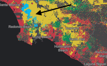
* The image below visualizes population by Census tract using dot density. Notice that each
|
|
124
124
|
* dot represents about 100 people.
|
|
125
125
|
*
|
|
126
|
-
* 
|
|
127
127
|
*
|
|
128
128
|
* You can specify multiple [attributes](https://developers.arcgis.com/javascript/latest/references/core/renderers/DotDensityRenderer/#attributes) to visualize subcategories of the data.
|
|
129
129
|
* For example, we can visualize the same layer above, but categorize each dot by race/ethnicity. So each
|
|
130
130
|
* dot of a different color represents 100 people of the respective category (e.g. 1 red dot represents
|
|
131
131
|
* 100 white non-Hispanic) people, each blue dot = 100 African American people, each yellow dot = 100 Hispanic people, etc).
|
|
132
132
|
*
|
|
133
|
-
* [](https://developers.arcgis.com/javascript/latest/sample-code/visualization-dot-density/)
|
|
134
134
|
*
|
|
135
135
|
* This implementation of dot density allows you to linearly scale the dot value based on the [view scale](https://developers.arcgis.com/javascript/latest/references/core/views/MapView/#scale).
|
|
136
136
|
* So as you zoom in and out of the initial view, the relative density of points remains the same across scales.
|
|
@@ -276,7 +276,7 @@ export default class DotDensityRenderer extends DotDensityRendererSuperclass {
|
|
|
276
276
|
*
|
|
277
277
|
* Blend enabled | Blend disabled
|
|
278
278
|
* --------------|---------------
|
|
279
|
-
*  | 
|
|
280
280
|
*
|
|
281
281
|
* @default true
|
|
282
282
|
*/
|
|
@@ -120,7 +120,7 @@ export interface FlowRendererProperties extends VisualVariablesMixinProperties,
|
|
|
120
120
|
* To use this renderer, the [source type of your raster dataset](https://pro.arcgis.com/en/pro-app/latest/help/data/imagery/raster-dataset-properties.htm) must be `Vector-UV` or `Vector-MagDir`.
|
|
121
121
|
* The direction of the raster defines the direction of movement, and the magnitude defines the visible length of the streamline.
|
|
122
122
|
*
|
|
123
|
-
* [](https://developers.arcgis.com/javascript/latest/sample-code/layers-imagery-afrenderer/)
|
|
124
124
|
*
|
|
125
125
|
* <span id="streamline-animation"></span>
|
|
126
126
|
* ## Streamline animation
|
|
@@ -131,7 +131,7 @@ export interface FlowRendererProperties extends VisualVariablesMixinProperties,
|
|
|
131
131
|
* The FlowRenderer displays animated streamlines by moving a visible trail (in red) along a precomputed path, or streamline (in black).
|
|
132
132
|
* This path represents the full route of flow and is based on the direction of the underlying data.
|
|
133
133
|
*
|
|
134
|
-
* 
|
|
135
135
|
*
|
|
136
136
|
* The trail's length and speed are initially influenced by the magnitude of the source data. To give users more control, the following properties can be adjusted:
|
|
137
137
|
*
|
|
@@ -202,7 +202,7 @@ export default class FlowRenderer extends FlowRendererSuperclass {
|
|
|
202
202
|
*
|
|
203
203
|
* |`density = 0.1` | `density = 1` | `density = 1.5` |
|
|
204
204
|
* |----------------|-----------------|---------------|
|
|
205
|
-
* |  |  |  |
|
|
206
206
|
*
|
|
207
207
|
* @default 0.8
|
|
208
208
|
*/
|
|
@@ -212,8 +212,8 @@ export default class FlowRenderer extends FlowRendererSuperclass {
|
|
|
212
212
|
*
|
|
213
213
|
* Value | Description | Example
|
|
214
214
|
* ------|-------------|---------
|
|
215
|
-
* flow-from | Flow from angle. | 
|
|
216
|
+
* flow-to | Flow to angle. | 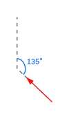
|
|
217
217
|
*
|
|
218
218
|
* @default "flow-from"
|
|
219
219
|
*/
|
|
@@ -280,7 +280,7 @@ export default class FlowRenderer extends FlowRendererSuperclass {
|
|
|
280
280
|
* The actual trail length is first based on the data, then further scaled by this property.
|
|
281
281
|
* |`trailLength = 20` | `trailLength = 100` | `trailLength = 250` |
|
|
282
282
|
* |----------------|-----------------|---------------|
|
|
283
|
-
* |  |  |  |
|
|
284
284
|
*
|
|
285
285
|
* @default 100
|
|
286
286
|
* @see [Streamline animation](https://developers.arcgis.com/javascript/latest/references/core/renderers/FlowRenderer/#streamline-animation)
|
|
@@ -241,9 +241,9 @@ export default class HeatmapRenderer extends Renderer {
|
|
|
241
241
|
*
|
|
242
242
|
* Zoom offset from reference scale | Static (reference scale) | Dynamic (no reference scale)
|
|
243
243
|
* ------------------------------|----------|--------------
|
|
244
|
-
* +1 LOD |  | 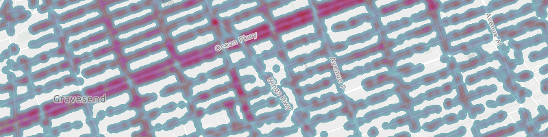
|
|
245
|
+
* reference scale | 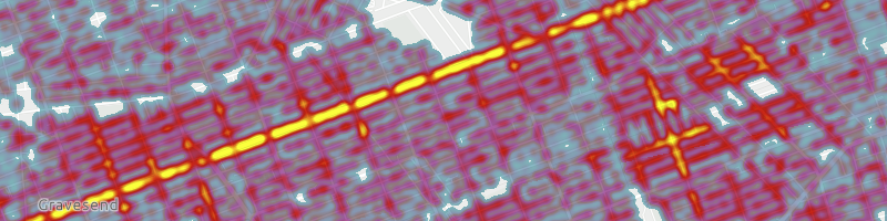 | 
|
|
246
|
+
* -1 LOD | 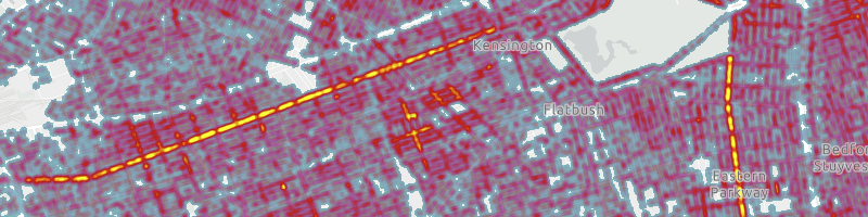 | 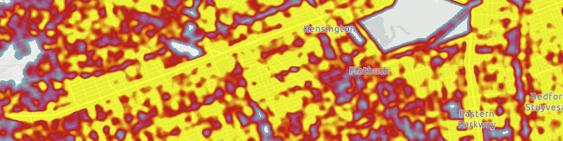
|
|
247
247
|
*
|
|
248
248
|
* @default 0
|
|
249
249
|
* @since 4.24
|
|
@@ -147,7 +147,7 @@ export interface PieChartRendererProperties extends RendererProperties, VisualVa
|
|
|
147
147
|
* property. You can vary the size of each pie based on data with any other field value or Arcade
|
|
148
148
|
* expression using [visualVariables](https://developers.arcgis.com/javascript/latest/references/core/renderers/PieChartRenderer/#visualVariables).
|
|
149
149
|
*
|
|
150
|
-
* [](https://developers.arcgis.com/javascript/latest/sample-code/visualization-pie-chart/)
|
|
151
151
|
*
|
|
152
152
|
* > [!WARNING]
|
|
153
153
|
* >
|
|
@@ -21,7 +21,7 @@ export interface RasterShadedReliefRendererProperties extends Partial<Pick<Raste
|
|
|
21
21
|
*
|
|
22
22
|
* Traditional | Multi-directional |
|
|
23
23
|
* ----------- | ----------------- |
|
|
24
|
-
* <img alt="Undo update" src="https://developers.arcgis.com/javascript/latest/assets/
|
|
24
|
+
* <img alt="Undo update" src="https://developers.arcgis.com/javascript/latest/assets/references/core/renderers/renderer-shadedRelief-traditional.png">|<img alt="Undo update" src="https://developers.arcgis.com/javascript/latest/assets/references/core/renderers/renderer-shadedRelief-multidirectional.png">|
|
|
25
25
|
*
|
|
26
26
|
* @since 4.16
|
|
27
27
|
* @see [Hillshade function](https://pro.arcgis.com/en/pro-app/latest/help/data/imagery/hillshade-function.htm)
|
package/renderers/Renderer.d.ts
CHANGED
|
@@ -68,7 +68,7 @@ export interface RendererProperties {
|
|
|
68
68
|
* to which the highway belongs. For example, green lines are highways in the "Tampa District" whereas
|
|
69
69
|
* red lines are highways in the "Central District".
|
|
70
70
|
*
|
|
71
|
-
* [](https://developers.arcgis.com/javascript/latest/sample-code/visualization-location-types/)
|
|
72
72
|
*
|
|
73
73
|
* Read more on the [UniqueValueRenderer](https://developers.arcgis.com/javascript/latest/references/core/renderers/UniqueValueRenderer/) page.
|
|
74
74
|
*
|
|
@@ -98,7 +98,7 @@ export interface RendererProperties {
|
|
|
98
98
|
* visual variable to map predominant types and the strength of their predominance in relation
|
|
99
99
|
* to other variables.
|
|
100
100
|
*
|
|
101
|
-
* [](https://developers.arcgis.com/javascript/latest/sample-code/visualization-vv-color/)
|
|
102
102
|
*
|
|
103
103
|
* See [visual variables](https://developers.arcgis.com/javascript/latest/references/core/renderers/SimpleRenderer/#visualVariables) for more information.
|
|
104
104
|
*
|
|
@@ -65,7 +65,7 @@ export interface SimpleRendererProperties extends RendererProperties, VisualVari
|
|
|
65
65
|
* [SceneView](https://developers.arcgis.com/javascript/latest/references/core/views/SceneView/) to thematically visualize a hurricane's windspeed in
|
|
66
66
|
* various locations along its path.
|
|
67
67
|
*
|
|
68
|
-
* [](https://developers.arcgis.com/javascript/latest/sample-code/visualization-multivariate-3d/)
|
|
69
69
|
*
|
|
70
70
|
* To read more about visual variables, see the [visualVariables](https://developers.arcgis.com/javascript/latest/references/core/renderers/SimpleRenderer/#visualVariables) property.
|
|
71
71
|
*
|
|
@@ -54,7 +54,7 @@ export interface VectorFieldRendererProperties extends VisualVariablesMixinPrope
|
|
|
54
54
|
* It can also be used to symbolize a single raster layer where the symbols are scalar.
|
|
55
55
|
* The direction of the raster defines the angles, while the magnitude of the raster defines the size of the symbol.
|
|
56
56
|
*
|
|
57
|
-
* [](https://developers.arcgis.com/javascript/latest/sample-code/layers-imagery-vfrenderer/)
|
|
58
58
|
*
|
|
59
59
|
* > [!WARNING]
|
|
60
60
|
* >
|
|
@@ -17,9 +17,9 @@ export interface VisualVariablesMixinProperties {
|
|
|
17
17
|
*
|
|
18
18
|
* Type | Object Specification | Legend Example
|
|
19
19
|
* -----|----------------------|---------------
|
|
20
|
-
* color | [ColorVisualVariable](https://developers.arcgis.com/javascript/latest/references/core/renderers/visualVariables/ColorVariable/) |  |  |  | 
|
|
21
|
+
* size | [SizeVisualVariable](https://developers.arcgis.com/javascript/latest/references/core/renderers/visualVariables/SizeVariable/) | 
|
|
22
|
+
* opacity | [OpacityVisualVariable](https://developers.arcgis.com/javascript/latest/references/core/renderers/visualVariables/OpacityVariable/) | 
|
|
23
23
|
* rotation | [RotationVisualVariable](https://developers.arcgis.com/javascript/latest/references/core/renderers/visualVariables/RotationVariable/) | -
|
|
24
24
|
*
|
|
25
25
|
* Visual variables are primarily be used in two ways.
|
|
@@ -52,7 +52,7 @@ export interface VisualVariablesMixinProperties {
|
|
|
52
52
|
* The sample below uses
|
|
53
53
|
* three visual variables (size, color, and opacity).
|
|
54
54
|
*
|
|
55
|
-
* [](https://developers.arcgis.com/javascript/latest/sample-code/visualization-multivariate-2d/)
|
|
56
56
|
*
|
|
57
57
|
* #### 2. Mapping real-world sizes
|
|
58
58
|
*
|
|
@@ -98,9 +98,9 @@ export abstract class VisualVariablesMixin {
|
|
|
98
98
|
*
|
|
99
99
|
* Type | Object Specification | Legend Example
|
|
100
100
|
* -----|----------------------|---------------
|
|
101
|
-
* color | [ColorVisualVariable](https://developers.arcgis.com/javascript/latest/references/core/renderers/visualVariables/ColorVariable/) |  |  |  | 
|
|
102
|
+
* size | [SizeVisualVariable](https://developers.arcgis.com/javascript/latest/references/core/renderers/visualVariables/SizeVariable/) | 
|
|
103
|
+
* opacity | [OpacityVisualVariable](https://developers.arcgis.com/javascript/latest/references/core/renderers/visualVariables/OpacityVariable/) | 
|
|
104
104
|
* rotation | [RotationVisualVariable](https://developers.arcgis.com/javascript/latest/references/core/renderers/visualVariables/RotationVariable/) | -
|
|
105
105
|
*
|
|
106
106
|
* Visual variables are primarily be used in two ways.
|
|
@@ -133,7 +133,7 @@ export abstract class VisualVariablesMixin {
|
|
|
133
133
|
* The sample below uses
|
|
134
134
|
* three visual variables (size, color, and opacity).
|
|
135
135
|
*
|
|
136
|
-
* [](https://developers.arcgis.com/javascript/latest/sample-code/visualization-multivariate-2d/)
|
|
137
137
|
*
|
|
138
138
|
* #### 2. Mapping real-world sizes
|
|
139
139
|
*
|
|
@@ -1,2 +1,2 @@
|
|
|
1
1
|
/* COPYRIGHT Esri - https://js.arcgis.com/5.1/LICENSE.txt */
|
|
2
|
-
import{__decorate as e}from"tslib";import t from"../../config.js";import{id as s}from"../../kernel.js";import r from"../../request.js";import{isSome as i}from"../../core/arrayUtils.js";import a from"../../core/Error.js";import{IdentifiableMixin as o}from"../../core/Identifiable.js";import{JSONSupportMixin as n}from"../../core/JSONSupport.js";import{clone as l}from"../../core/lang.js";import{Loadable as u}from"../../core/Loadable.js";import{throwIfAborted as d,throwIfAbortError as p}from"../../core/promiseUtils.js";import{property as c,subclass as m}from"../../core/accessorSupport/decorators.js";import y from"../../geometry/SpatialReference.js";import{curveTypeDict as h}from"../../geometry/support/typeUtils.js";import{getFeatureJSON as f,getFeatureIds as b,getAttachmentEditsJSON as v,isProtectedOrPrivateVersionError as g,unpackEditResultData as j,createEditedFeatures as S}from"../../layers/graphics/applyEditsUtils.js";import{checkEditingCapabilities as A,normalizeEdits as C,processGeometries as T}from"../../layers/graphics/editingSupport.js";import{emitApplyEditsEvent as O}from"../../layers/mixins/EditBusLayer.js";import{isHostedAgolService as E}from"../../layers/support/arcgisLayerUrl.js";import{ensureCredentialIfSignedIn as I}from"../../layers/support/featureLayerUtils.js";import{getOwningPortalUrl as w}from"../../layers/support/layerUtils.js";import{getFeatureLayerCapabilities as F,allCurveTypes as R}from"../../layers/support/serviceCapabilitiesUtils.js";import U from"../../portal/PortalItem.js";import{getUserPrivileges as D}from"../../portal/support/portalItemUtils.js";import{isSecureProxyService as P}from"../../portal/support/urlUtils.js";import{parseUrl as V,asValidOptions as G,encode as _}from"../utils.js";import{unapplyEditsZUnitScaling as k}from"../query/operations/editsZScale.js";import{readBoolean as x,readNumber as M}from"../support/jsonUtils.js";import{isSafeToEditVersion as N,isVersionInEditSession as L,currentSessionId as J}from"../../versionManagement/support/versionManagementUtils.js";import{reader as Q}from"../../core/accessorSupport/decorators/reader.js";function q(e,t){const s=t.id;return{id:s,name:t.name,url:`${e}/${s}`,type:t.type||"Table"}}function H(e){return{data:W(e),sync:Z(e),operations:B(e.capabilities,e),query:$(e),editing:z(e)}}function W(e){const t=x(e,"supportsTrueCurve",!1);return{isDataVersioned:x(e,"hasVersionedData",!1),isDataBranchVersioned:x(e,"hasBranchVersionedData",!1),supportsTrueCurve:t,supportedCurveTypes:K(e,t)}}function B(e,t){const s=e?e.toLowerCase().split(",").map(e=>e.trim()):[],r=s.includes("query"),i=s.includes("editing")&&!t.datesInUnknownTimezone;let a=i&&s.includes("create"),o=i&&s.includes("delete"),n=i&&s.includes("update");return i&&!(a||o||n)&&(a=o=n=!0),{supportsAdd:a,supportsDelete:o,supportsEditing:i,supportsChangeTracking:s.includes("changetracking"),supportsQuery:r,supportsQueryDataElements:x(t,"supportsQueryDataElements",!1),supportsQueryDomains:x(t,"supportsQueryDomains",!1),supportsQueryContingentValues:x(t,"supportsQueryContingentValues",!1),supportsSync:s.includes("sync"),supportsUpdate:n}}function $(e){return{maxRecordCountFactor:M(e,"maxRecordCountFactor",void 0),maxRecordCount:M(e,"maxRecordCount",void 0)}}function z(e){const t=e?.advancedEditingCapabilities;return{supportsAsyncApplyEdits:x(t,"supportsAsyncApplyEdits",!1),supportsGlobalId:x(e,"supportsApplyEditsWithGlobalIds",!1),supportsReturnServiceEditsInSourceSpatialReference:x(t,"supportsReturnServiceEditsInSourceSR",!1),supportsSharedTemplates:x(e,"supportsSharedTemplates",!1)||x(e,"hasSharedTemplates",!1),supportsSplit:x(t,"supportsSplit",!1),supportsTrueCurveUpdate:x(e,"allowTrueCurvesUpdates",!1),supportsTrueCurveUpdateByTrueCurveClientsOnly:x(e,"onlyAllowTrueCurveUpdatesByTrueCurveClients",!0)}}function Z(e){const t=e?.syncCapabilities,s=t?.supportedSyncDataOptions;return{supportsAsync:x(t,"supportsAsync",!1),supportedSyncDataOptions:{annotations:!(1&~s),dimensions:!(2&~s),contingentValues:!(4&~s),attributeRules:!(8&~s),utilityNetworkSystem:!(16&~s),annotationFullModel:!(32&~s),include3DObjects:!(64&~s),utilityNetworkMissingLayers:!(128&~s),preserveTrueCurves:!(256&~s)}}}function K(e,t){return Array.isArray(e.supportedCurveTypes)?e.supportedCurveTypes.map(e=>h.fromJSON(e)).filter(i):t?R:[]}let X=class extends(n(o(u))){constructor(e){super(e),this.url=null,this.sourceJSON=null,this.userHasFullEditingPrivileges=!1,this.userHasUpdateItemPrivileges=!1,this.userTypeExtensions=[],this.layerInfos=null,this.tableInfos=null,this.capabilities=null,this._layerTableIndex=new Map,this._xyToleranceCache=new Map}read(e,t){this.sourceJSON=e,super.read(e,t)}get utilityNetworkUrl(){if(this.sourceJSON)for(const e of this.sourceJSON.layers)if("Utility Network Layer"===e.type)return`${this.url}/${e.id}`;return null}get versionManagementServiceUrl(){return this.sourceJSON?.hasBranchVersionedData&&!P(this.url)?this.url.replace(/\/FeatureServer/i,"/VersionManagementServer"):null}readLayerInfos(e,t){return(t.layers||[]).map(e=>{const{type:t,geometryType:s}=e;return{...q(this.url,e),type:t||"Feature Layer",geometryType:s}})}readTableInfos(e,t){return(t.tables||[]).map(e=>q(this.url,e))}readCapabilities(e,t){return H(t)}get effectiveCapabilities(){const e=this.capabilities;if(!e)return null;const t=l(e),{operations:s}=t;return this.userHasUpdateItemPrivileges?(s.supportsAdd=s.supportsDelete=s.supportsEditing=s.supportsQuery=s.supportsUpdate=!0,t):(this.userHasFullEditingPrivileges&&s.supportsEditing&&(s.supportsAdd=s.supportsDelete=s.supportsUpdate=!0),t)}get loaded(){return super.loaded}get _isHostedAgolService(){return E(this.url)}load(e){return this.addResolvingPromise(this._fetchService(this.url,e).then(()=>this._setUserPrivileges(e))),Promise.resolve(this)}async fetchAllLayersAndTables(e){return await this.load(e),this._fetchLayersAndTablesPromise||=this._fetchLayersAndTables(this.url),d(e),this._fetchLayersAndTablesPromise}async applyEdits(e,t){let s=null;try{const{results:r,edits:i,editedFeatures:a}=await this._internalApplyEdits(e,t),o=e=>e.filter(e=>!e.error).map(l);let n=0;return r.map(e=>{s=O(this.url,e.id,t?.gdbVersion,!0);const r={edits:i[n],addedFeatures:o(e.addFeatureResults),updatedFeatures:o(e.updateFeatureResults),deletedFeatures:o(e.deleteFeatureResults),addedAttachments:o(e.addAttachmentResults),updatedAttachments:o(e.updateAttachmentResults),deletedAttachments:o(e.deleteAttachmentResults),exceededTransferLimit:!1,historicMoment:e.editMoment?new Date(e.editMoment):null};n+=1,a.length>0&&(r.editedFeatures=a),s.resolve(r),s=null}),r}catch(r){throw s&&s.reject(r),r}}async _setUserPrivileges(e){if(t.userPrivilegesApplied)try{const{features:{fullEdit:t},content:{updateItem:s}}=await this._fetchUserPrivileges(this.sourceJSON.serviceItemId,e);this._set("userHasFullEditingPrivileges",t),this._set("userHasUpdateItemPrivileges",s)}catch(s){p(s)}}async _fetchUserPrivileges(e,t){const r=!0,i=!1,a=!1;if(!e)return{features:{edit:r,fullEdit:i},content:{updateItem:a}};let o,n,l;try{o=await w(this.url,t)}catch(u){p(u)}try{const e=null!=t?t.signal:null;n=await(s?.getCredential(`${o}/sharing`,{prompt:!1,signal:e}))}catch(u){p(u)}if(!n)return{features:{edit:r,fullEdit:i},content:{updateItem:a}};try{if(l=new U({id:e,portal:{url:o}}),await l.load(t),l.portal.user)return D(l)}catch(u){p(u)}return{features:{edit:r,fullEdit:i},content:{updateItem:a}}}async _internalApplyEdits(e,t){await I(this.url);const s=t?.globalIdUsed??!1,a=y.fromJSON(this.sourceJSON.spatialReference),{edits:o,options:n}=await this._processApplyEditsParams(e,t),l=await Promise.all(o.map(async e=>{const t=e.addFeatures?.map(e=>f({spatialReference:a},e,null))??[],r=(await Promise.all(t)).filter(i),o=r.length>0?r:null,n=e.updateFeatures?.map(e=>f({spatialReference:a},e,null))??[],l=(await Promise.all(n)).filter(i),u=l.length>0?l:null,d=b(e.identifierFields,e.deleteFeatures,s),p=d.length>0?d:null;k(o,u,a);const c=await v(e.identifierFields,e);let m=null;if(c){m={adds:c.adds.length>0?c.adds:void 0,updates:c.updates.length>0?c.updates:void 0,deletes:c.deletes.length>0?c.deletes:void 0}}const y={};return e.deleteAssociations&&(y.deleteAssociations=e.deleteAssociations),e.combineGroupedObjects&&(y.combineGroupedObjects=e.combineGroupedObjects),e.divideGroupedObjects&&(y.divideGroupedObjects=e.divideGroupedObjects),{id:e.id,adds:o,updates:u,deletes:p,attachments:m,...y}})),u={gdbVersion:n?.gdbVersion,rollbackOnFailure:!0,useGlobalIds:s,returnEditMoment:!0,honorSequenceOfEdits:n?.honorSequenceOfEdits,trueCurveClient:n?.editsRespectTrueCurves,usePreviousEditMoment:n?.usePreviousEditMoment,returnServiceEditsInSourceSR:!1,returnServiceEditsOption:"originalAndCurrentFeatures",async:!1};await N(this.url,t?.gdbVersion,!0);const d=L(this.url,t?.gdbVersion||null);u.edits=JSON.stringify(l);const p=V(this.url),c=G(p.query,{query:_({...u,f:"json"}),method:"post"});let m;d&&(c.authMode="immediate",c.query.sessionId=J);try{m=await r(this.url+"/applyEdits",c)}catch(h){if(!g(h))throw h;c.authMode="immediate",m=await r(this.url+"/applyEdits",c)}return{...Y(m),edits:o}}async _processApplyEditsParams(e,t){const s={...t,usingFeatureServiceEndpoint:!0,usingTelecomOperations:e.some(e=>e.deleteAssociations||e.combineGroupedObjects||e.divideGroupedObjects)};return{edits:await Promise.all(e.map(async e=>{const t=this.effectiveCapabilities,r=e&&(e.addFeatures||e.updateFeatures||e.deleteFeatures),i=e&&(e.addAttachments||e.updateAttachments||e.deleteAttachments);if(A(e,t,s,!!r,!!i,"feature-service"),!t.data.isDataVersioned&&s?.gdbVersion)throw new a("feature-service:invalid-parameter","'gdbVersion' is applicable only if the layer supports versioned data. See: 'capabilities.data.isDataVersioned'");const o=C(e,t,"feature-service"),n={};if(e.deleteAssociations&&(n.deleteAssociations=e.deleteAssociations),e.combineGroupedObjects&&(n.combineGroupedObjects=e.combineGroupedObjects),e.divideGroupedObjects&&(n.divideGroupedObjects=e.divideGroupedObjects),!e.identifierFields){await this.fetchAllLayersAndTables();const t=this._layerTableIndex.get(e.id);t&&(e.identifierFields={globalIdField:t.globalIdField,objectIdField:t.objectIdField})}const l=await T(o,t.data.supportedCurveTypes,this._isHostedAgolService,this._xyToleranceCache);return{id:e.id,...l,...n,identifierFields:e.identifierFields}})),options:s}}async _fetchService(e,t){if(this.sourceJSON)return void this.read(this.sourceJSON,{url:V(e)});const s=await r(e,{responseType:"json",query:{f:"json"},...t});this.read(s.data,{url:V(e)})}async _fetchLayersAndTables(e){const t=`${e}/layers`,s=await r(t,{responseType:"json",query:{f:"json"}});return{layers:s.data.layers.map(e=>{const{type:t,geometryType:s}=e,r=q(this.url,e),i=F(e,r.url);return this._layerTableIndex.set(e.id,e),{...r,type:t||"Feature Layer",geometryType:s,capabilities:i}}),tables:s.data.tables.map(e=>{const t=q(this.url,e),s=F(e,t.url);return this._layerTableIndex.set(e.id,e),{...t,capabilities:s}})}}};function Y(e){const t=e.data,s=[];return{results:t.map(e=>{const t={addResults:e.addResults??[],updateResults:e.updateResults??[],deleteResults:e.deleteResults??[],attachments:e.attachments,editMoment:e.editMoment},r=j(t),i=e.editedFeatures,a=i?.spatialReference?new y({wkid:i?.spatialReference.wkid,wkt:i?.spatialReference.wkt,latestWkid:i?.spatialReference.latestWkid,latestVcsWkid:i?.spatialReference.latestVcsWkid,vcsWkid:i?.spatialReference.vcsWkid}):null,o=i?S(i,a):null;o&&s.push({layerId:e.id,editedFeatures:o});const n={};return e.divideGroupedObjectResults&&(n.divideGroupedObjectResults=e.divideGroupedObjectResults),e.combineGroupedObjectResults&&(n.combineGroupedObjectResults=e.combineGroupedObjectResults),{id:e.id,editedFeatures:o,...r,...n}}),editedFeatures:s}}e([c()],X.prototype,"url",void 0),e([c()],X.prototype,"sourceJSON",void 0),e([c()],X.prototype,"userHasFullEditingPrivileges",void 0),e([c()],X.prototype,"userHasUpdateItemPrivileges",void 0),e([c({readOnly:!0})],X.prototype,"utilityNetworkUrl",null),e([c({readOnly:!0})],X.prototype,"versionManagementServiceUrl",null),e([c()],X.prototype,"userTypeExtensions",void 0),e([c({json:{read:{source:["layers"]}}})],X.prototype,"layerInfos",void 0),e([Q("layerInfos",["layers"])],X.prototype,"readLayerInfos",null),e([c({json:{read:{source:["tables"]}}})],X.prototype,"tableInfos",void 0),e([Q("tableInfos",["tables"])],X.prototype,"readTableInfos",null),e([c({readOnly:!0,json:{read:{source:["hasVersionedData","hasSharedTemplates","hasBranchVersionedData","capabilities","supportsQueryDataElements","supportsQueryDomains","supportsQueryContingentValues","maxRecordCountFactor","maxRecordCount","advancedEditingCapabilities","supportsApplyEditsWithGlobalIds","syncCapabilities","datesInUnknownTimezone"]}}})],X.prototype,"capabilities",void 0),e([Q("capabilities",["hasVersionedData","hasSharedTemplates","hasBranchVersionedData","capabilities","supportsQueryDataElements","supportsQueryDomains","supportsQueryContingentValues","maxRecordCountFactor","maxRecordCount","advancedEditingCapabilities","supportsApplyEditsWithGlobalIds","syncCapabilities","datesInUnknownTimezone"])],X.prototype,"readCapabilities",null),e([c({readOnly:!0})],X.prototype,"effectiveCapabilities",null),e([c()],X.prototype,"_isHostedAgolService",null),X=e([m("esri.rest.featureService.FeatureService")],X);const ee=X;export{ee as default};
|
|
2
|
+
import{__decorate as e}from"tslib";import t from"../../config.js";import{id as s}from"../../kernel.js";import r from"../../request.js";import{isSome as i}from"../../core/arrayUtils.js";import a from"../../core/Error.js";import{IdentifiableMixin as o}from"../../core/Identifiable.js";import{JSONSupportMixin as n}from"../../core/JSONSupport.js";import{clone as l}from"../../core/lang.js";import{Loadable as u}from"../../core/Loadable.js";import{throwIfAborted as d,throwIfAbortError as p}from"../../core/promiseUtils.js";import{property as c,subclass as m}from"../../core/accessorSupport/decorators.js";import y from"../../geometry/SpatialReference.js";import{curveTypeDict as h}from"../../geometry/support/typeUtils.js";import{getFeatureJSON as f,getFeatureIds as b,getAttachmentEditsJSON as v,isProtectedOrPrivateVersionError as g,unpackEditResultData as j,createEditedFeatures as S}from"../../layers/graphics/applyEditsUtils.js";import{checkEditingCapabilities as C,normalizeEdits as T,processGeometries as A}from"../../layers/graphics/editingSupport.js";import{emitApplyEditsEvent as E}from"../../layers/mixins/EditBusLayer.js";import{isHostedAgolService as F}from"../../layers/support/arcgisLayerUrl.js";import{ensureCredentialIfSignedIn as O}from"../../layers/support/featureLayerUtils.js";import{getOwningPortalUrl as I}from"../../layers/support/layerUtils.js";import{getFeatureLayerCapabilities as w,allCurveTypes as R}from"../../layers/support/serviceCapabilitiesUtils.js";import U from"../../portal/PortalItem.js";import{getUserPrivileges as P}from"../../portal/support/portalItemUtils.js";import{isSecureProxyService as D}from"../../portal/support/urlUtils.js";import{parseUrl as V,asValidOptions as G,encode as _}from"../utils.js";import{unapplyEditsZUnitScaling as k}from"../query/operations/editsZScale.js";import{readBoolean as x,readNumber as M}from"../support/jsonUtils.js";import{isSafeToEditVersion as N,isVersionInEditSession as L,currentSessionId as J}from"../../versionManagement/support/versionManagementUtils.js";import{reader as Q}from"../../core/accessorSupport/decorators/reader.js";function q(e,t){const s=t.id;return{id:s,name:t.name,url:`${e}/${s}`,type:t.type||"Table"}}function H(e){return{data:W(e),sync:K(e),operations:B(e.capabilities,e),query:$(e),editing:Z(e)}}function W(e){const t=x(e,"supportsTrueCurve",!1);return{isDataVersioned:x(e,"hasVersionedData",!1),isDataBranchVersioned:x(e,"hasBranchVersionedData",!1),supportsTrueCurve:t,supportedCurveTypes:X(e,t)}}function B(e,t){const s=e?e.toLowerCase().split(",").map(e=>e.trim()):[],r=s.includes("query"),i=s.includes("editing")&&!t.datesInUnknownTimezone;let a=i&&s.includes("create"),o=i&&s.includes("delete"),n=i&&s.includes("update");return i&&!(a||o||n)&&(a=o=n=!0),{supportsAdd:a,supportsDelete:o,supportsEditing:i,supportsChangeTracking:s.includes("changetracking"),supportsQuery:r,supportsQueryDataElements:x(t,"supportsQueryDataElements",!1),supportsQueryDomains:x(t,"supportsQueryDomains",!1),supportsQueryContingentValues:x(t,"supportsQueryContingentValues",!1),supportsSync:s.includes("sync"),supportsUpdate:n}}function $(e){return{maxRecordCountFactor:M(e,"maxRecordCountFactor",void 0),maxRecordCount:M(e,"maxRecordCount",void 0),supportsTrueCurveWithPBF:z(e)}}function z(e){return!!Array.isArray(e.supportedTrueCurvePbfFeatureEncodings)&&e.supportedTrueCurvePbfFeatureEncodings.includes("esriDefault")}function Z(e){const t=e?.advancedEditingCapabilities;return{supportsAsyncApplyEdits:x(t,"supportsAsyncApplyEdits",!1),supportsGlobalId:x(e,"supportsApplyEditsWithGlobalIds",!1),supportsReturnServiceEditsInSourceSpatialReference:x(t,"supportsReturnServiceEditsInSourceSR",!1),supportsSharedTemplates:x(e,"supportsSharedTemplates",!1)||x(e,"hasSharedTemplates",!1),supportsSplit:x(t,"supportsSplit",!1),supportsTrueCurveUpdate:x(e,"allowTrueCurvesUpdates",!1),supportsTrueCurveUpdateByTrueCurveClientsOnly:x(e,"onlyAllowTrueCurveUpdatesByTrueCurveClients",!0)}}function K(e){const t=e?.syncCapabilities,s=t?.supportedSyncDataOptions;return{supportsAsync:x(t,"supportsAsync",!1),supportedSyncDataOptions:{annotations:!(1&~s),dimensions:!(2&~s),contingentValues:!(4&~s),attributeRules:!(8&~s),utilityNetworkSystem:!(16&~s),annotationFullModel:!(32&~s),include3DObjects:!(64&~s),utilityNetworkMissingLayers:!(128&~s),preserveTrueCurves:!(256&~s)}}}function X(e,t){return Array.isArray(e.supportedCurveTypes)?e.supportedCurveTypes.map(e=>h.fromJSON(e)).filter(i):t?R:[]}let Y=class extends(n(o(u))){constructor(e){super(e),this.url=null,this.sourceJSON=null,this.userHasFullEditingPrivileges=!1,this.userHasUpdateItemPrivileges=!1,this.userTypeExtensions=[],this.layerInfos=null,this.tableInfos=null,this.capabilities=null,this._layerTableIndex=new Map,this._xyToleranceCache=new Map}read(e,t){this.sourceJSON=e,super.read(e,t)}get utilityNetworkUrl(){if(this.sourceJSON)for(const e of this.sourceJSON.layers)if("Utility Network Layer"===e.type)return`${this.url}/${e.id}`;return null}get versionManagementServiceUrl(){return this.sourceJSON?.hasBranchVersionedData&&!D(this.url)?this.url.replace(/\/FeatureServer/i,"/VersionManagementServer"):null}readLayerInfos(e,t){return(t.layers||[]).map(e=>{const{type:t,geometryType:s}=e;return{...q(this.url,e),type:t||"Feature Layer",geometryType:s}})}readTableInfos(e,t){return(t.tables||[]).map(e=>q(this.url,e))}readCapabilities(e,t){return H(t)}get effectiveCapabilities(){const e=this.capabilities;if(!e)return null;const t=l(e),{operations:s}=t;return this.userHasUpdateItemPrivileges?(s.supportsAdd=s.supportsDelete=s.supportsEditing=s.supportsQuery=s.supportsUpdate=!0,t):(this.userHasFullEditingPrivileges&&s.supportsEditing&&(s.supportsAdd=s.supportsDelete=s.supportsUpdate=!0),t)}get loaded(){return super.loaded}get _isHostedAgolService(){return F(this.url)}load(e){return this.addResolvingPromise(this._fetchService(this.url,e).then(()=>this._setUserPrivileges(e))),Promise.resolve(this)}async fetchAllLayersAndTables(e){return await this.load(e),this._fetchLayersAndTablesPromise||=this._fetchLayersAndTables(this.url),d(e),this._fetchLayersAndTablesPromise}async applyEdits(e,t){let s=null;try{const{results:r,edits:i,editedFeatures:a}=await this._internalApplyEdits(e,t),o=e=>e.filter(e=>!e.error).map(l);let n=0;return r.map(e=>{s=E(this.url,e.id,t?.gdbVersion,!0);const r={edits:i[n],addedFeatures:o(e.addFeatureResults),updatedFeatures:o(e.updateFeatureResults),deletedFeatures:o(e.deleteFeatureResults),addedAttachments:o(e.addAttachmentResults),updatedAttachments:o(e.updateAttachmentResults),deletedAttachments:o(e.deleteAttachmentResults),exceededTransferLimit:!1,historicMoment:e.editMoment?new Date(e.editMoment):null};n+=1,a.length>0&&(r.editedFeatures=a),s.resolve(r),s=null}),r}catch(r){throw s&&s.reject(r),r}}async _setUserPrivileges(e){if(t.userPrivilegesApplied)try{const{features:{fullEdit:t},content:{updateItem:s}}=await this._fetchUserPrivileges(this.sourceJSON.serviceItemId,e);this._set("userHasFullEditingPrivileges",t),this._set("userHasUpdateItemPrivileges",s)}catch(s){p(s)}}async _fetchUserPrivileges(e,t){const r=!0,i=!1,a=!1;if(!e)return{features:{edit:r,fullEdit:i},content:{updateItem:a}};let o,n,l;try{o=await I(this.url,t)}catch(u){p(u)}try{const e=null!=t?t.signal:null;n=await(s?.getCredential(`${o}/sharing`,{prompt:!1,signal:e}))}catch(u){p(u)}if(!n)return{features:{edit:r,fullEdit:i},content:{updateItem:a}};try{if(l=new U({id:e,portal:{url:o}}),await l.load(t),l.portal.user)return P(l)}catch(u){p(u)}return{features:{edit:r,fullEdit:i},content:{updateItem:a}}}async _internalApplyEdits(e,t){await O(this.url);const s=t?.globalIdUsed??!1,a=y.fromJSON(this.sourceJSON.spatialReference),{edits:o,options:n}=await this._processApplyEditsParams(e,t),l=await Promise.all(o.map(async e=>{const t=e.addFeatures?.map(e=>f({spatialReference:a},e,null))??[],r=(await Promise.all(t)).filter(i),o=r.length>0?r:null,n=e.updateFeatures?.map(e=>f({spatialReference:a},e,null))??[],l=(await Promise.all(n)).filter(i),u=l.length>0?l:null,d=b(e.identifierFields,e.deleteFeatures,s),p=d.length>0?d:null;k(o,u,a);const c=await v(e.identifierFields,e);let m=null;if(c){m={adds:c.adds.length>0?c.adds:void 0,updates:c.updates.length>0?c.updates:void 0,deletes:c.deletes.length>0?c.deletes:void 0}}const y={};return e.deleteAssociations&&(y.deleteAssociations=e.deleteAssociations),e.combineGroupedObjects&&(y.combineGroupedObjects=e.combineGroupedObjects),e.divideGroupedObjects&&(y.divideGroupedObjects=e.divideGroupedObjects),{id:e.id,adds:o,updates:u,deletes:p,attachments:m,...y}})),u={gdbVersion:n?.gdbVersion,rollbackOnFailure:!0,useGlobalIds:s,returnEditMoment:!0,honorSequenceOfEdits:n?.honorSequenceOfEdits,trueCurveClient:n?.editsRespectTrueCurves,usePreviousEditMoment:n?.usePreviousEditMoment,returnServiceEditsInSourceSR:!1,returnServiceEditsOption:"originalAndCurrentFeatures",async:!1};await N(this.url,t?.gdbVersion,!0);const d=L(this.url,t?.gdbVersion||null);u.edits=JSON.stringify(l);const p=V(this.url),c=G(p.query,{query:_({...u,f:"json"}),method:"post"});let m;d&&(c.authMode="immediate",c.query.sessionId=J);try{m=await r(this.url+"/applyEdits",c)}catch(h){if(!g(h))throw h;c.authMode="immediate",m=await r(this.url+"/applyEdits",c)}return{...ee(m),edits:o}}async _processApplyEditsParams(e,t){const s={...t,usingFeatureServiceEndpoint:!0,usingTelecomOperations:e.some(e=>e.deleteAssociations||e.combineGroupedObjects||e.divideGroupedObjects)};return{edits:await Promise.all(e.map(async e=>{const t=this.effectiveCapabilities,r=e&&(e.addFeatures||e.updateFeatures||e.deleteFeatures),i=e&&(e.addAttachments||e.updateAttachments||e.deleteAttachments);if(C(e,t,s,!!r,!!i,"feature-service"),!t.data.isDataVersioned&&s?.gdbVersion)throw new a("feature-service:invalid-parameter","'gdbVersion' is applicable only if the layer supports versioned data. See: 'capabilities.data.isDataVersioned'");const o=T(e,t,"feature-service"),n={};if(e.deleteAssociations&&(n.deleteAssociations=e.deleteAssociations),e.combineGroupedObjects&&(n.combineGroupedObjects=e.combineGroupedObjects),e.divideGroupedObjects&&(n.divideGroupedObjects=e.divideGroupedObjects),!e.identifierFields){await this.fetchAllLayersAndTables();const t=this._layerTableIndex.get(e.id);t&&(e.identifierFields={globalIdField:t.globalIdField,objectIdField:t.objectIdField})}const l=await A(o,t.data.supportedCurveTypes,this._isHostedAgolService,this._xyToleranceCache);return{id:e.id,...l,...n,identifierFields:e.identifierFields}})),options:s}}async _fetchService(e,t){if(this.sourceJSON)return void this.read(this.sourceJSON,{url:V(e)});const s=await r(e,{responseType:"json",query:{f:"json"},...t});this.read(s.data,{url:V(e)})}async _fetchLayersAndTables(e){const t=`${e}/layers`,s=await r(t,{responseType:"json",query:{f:"json"}});return{layers:s.data.layers.map(e=>{const{type:t,geometryType:s}=e,r=q(this.url,e),i=w(e,r.url);return this._layerTableIndex.set(e.id,e),{...r,type:t||"Feature Layer",geometryType:s,capabilities:i}}),tables:s.data.tables.map(e=>{const t=q(this.url,e),s=w(e,t.url);return this._layerTableIndex.set(e.id,e),{...t,capabilities:s}})}}};function ee(e){const t=e.data,s=[];return{results:t.map(e=>{const t={addResults:e.addResults??[],updateResults:e.updateResults??[],deleteResults:e.deleteResults??[],attachments:e.attachments,editMoment:e.editMoment},r=j(t),i=e.editedFeatures,a=i?.spatialReference?new y({wkid:i?.spatialReference.wkid,wkt:i?.spatialReference.wkt,latestWkid:i?.spatialReference.latestWkid,latestVcsWkid:i?.spatialReference.latestVcsWkid,vcsWkid:i?.spatialReference.vcsWkid}):null,o=i?S(i,a):null;o&&s.push({layerId:e.id,editedFeatures:o});const n={};return e.divideGroupedObjectResults&&(n.divideGroupedObjectResults=e.divideGroupedObjectResults),e.combineGroupedObjectResults&&(n.combineGroupedObjectResults=e.combineGroupedObjectResults),{id:e.id,editedFeatures:o,...r,...n}}),editedFeatures:s}}e([c()],Y.prototype,"url",void 0),e([c()],Y.prototype,"sourceJSON",void 0),e([c()],Y.prototype,"userHasFullEditingPrivileges",void 0),e([c()],Y.prototype,"userHasUpdateItemPrivileges",void 0),e([c({readOnly:!0})],Y.prototype,"utilityNetworkUrl",null),e([c({readOnly:!0})],Y.prototype,"versionManagementServiceUrl",null),e([c()],Y.prototype,"userTypeExtensions",void 0),e([c({json:{read:{source:["layers"]}}})],Y.prototype,"layerInfos",void 0),e([Q("layerInfos",["layers"])],Y.prototype,"readLayerInfos",null),e([c({json:{read:{source:["tables"]}}})],Y.prototype,"tableInfos",void 0),e([Q("tableInfos",["tables"])],Y.prototype,"readTableInfos",null),e([c({readOnly:!0,json:{read:{source:["hasVersionedData","hasSharedTemplates","hasBranchVersionedData","capabilities","supportsQueryDataElements","supportsQueryDomains","supportsQueryContingentValues","maxRecordCountFactor","maxRecordCount","advancedEditingCapabilities","supportsApplyEditsWithGlobalIds","syncCapabilities","datesInUnknownTimezone"]}}})],Y.prototype,"capabilities",void 0),e([Q("capabilities",["hasVersionedData","hasSharedTemplates","hasBranchVersionedData","capabilities","supportsQueryDataElements","supportsQueryDomains","supportsQueryContingentValues","maxRecordCountFactor","maxRecordCount","advancedEditingCapabilities","supportsApplyEditsWithGlobalIds","syncCapabilities","datesInUnknownTimezone"])],Y.prototype,"readCapabilities",null),e([c({readOnly:!0})],Y.prototype,"effectiveCapabilities",null),e([c()],Y.prototype,"_isHostedAgolService",null),Y=e([m("esri.rest.featureService.FeatureService")],Y);const te=Y;export{te as default};
|
|
@@ -1,9 +1,9 @@
|
|
|
1
1
|
import type FeatureLayer from "../../layers/FeatureLayer.js";
|
|
2
2
|
import type SubtypeGroupLayer from "../../layers/SubtypeGroupLayer.js";
|
|
3
3
|
import type FeatureService from "./FeatureService.js";
|
|
4
|
+
import type { EditedFeatures, Edits, FeatureEditResult } from "../../editing/types.js";
|
|
4
5
|
import type { CurveType } from "../../geometry/types.js";
|
|
5
6
|
import type { FeatureLayerCapabilities } from "../../layers/types.js";
|
|
6
|
-
import type { EditedFeatures, Edits, FeatureEditResult } from "../../layers/graphics/editingSupport.js";
|
|
7
7
|
import type { AssociationJsonType } from "../../networks/support/typeUtils.js";
|
|
8
8
|
import type { GeometryType } from "../support/types.js";
|
|
9
9
|
|
|
@@ -188,6 +188,12 @@ export interface QueryCapabilities {
|
|
|
188
188
|
* @since 5.0
|
|
189
189
|
*/
|
|
190
190
|
maxRecordCountFactor?: number | null;
|
|
191
|
+
/**
|
|
192
|
+
* Whether PBF-encoded true curves are supported.
|
|
193
|
+
*
|
|
194
|
+
* @since 5.0
|
|
195
|
+
*/
|
|
196
|
+
supportsTrueCurveWithPBF: boolean;
|
|
191
197
|
}
|
|
192
198
|
|
|
193
199
|
/** @since 5.0 */
|
|
@@ -1,2 +1,2 @@
|
|
|
1
1
|
/* COPYRIGHT Esri - https://js.arcgis.com/5.1/LICENSE.txt */
|
|
2
|
-
import{getMetersPerVerticalUnitForSR as
|
|
2
|
+
import{getMetersPerVerticalUnitForSR as e}from"../../../core/units.js";import{equals as n}from"../../../geometry/support/spatialReferenceUtils.js";import{getEndpoint as s}from"../../../geometry/support/curves/curveUtils.js";function o(e,n,s){if(null==e.hasM||e.hasZ)for(const o of n)for(const e of o)e.length>2&&(e[2]*=s)}function t(e,n,o){if(null==e.hasM||e.hasZ)for(const t of n)for(const e of t){const n=s(e);n.length>2&&(n[2]*=o)}}function i(n,s,o){if(!n&&!s||!o)return;const t=e(o);f(n,o,t),f(s,o,t)}function f(e,n,s){if(e)for(const o of e)r(o.geometry,n,s)}function r(s,i,f){if(!s?.spatialReference||n(s.spatialReference,i))return;const r=e(s.spatialReference)/f;if(1!==r)if("x"in s)null!=s.z&&(s.z*=r);else if("curveRings"in s)t(s,s.curveRings,r);else if("curvePaths"in s)t(s,s.curvePaths,r);else if("rings"in s)o(s,s.rings,r);else if("paths"in s)o(s,s.paths,r);else if("points"in s&&(null==s.hasM||s.hasZ))for(const e of s.points)e.length>2&&(e[2]*=r)}export{i as unapplyEditsZUnitScaling};
|
|
@@ -1,2 +1,2 @@
|
|
|
1
1
|
/* COPYRIGHT Esri - https://js.arcgis.com/5.1/LICENSE.txt */
|
|
2
|
-
import{allocateFlatGeometry as t,writeBezierCurveSegment as e,writeCircularArcSegment as s,writeEllipticArc7Segment as r}from"../../../geometry/FlatGeometry.js";import{featureGeometryTypeKebabDictionary as i}from"../../../geometry/support/typeUtils.js";import{zScale as h}from"../../../geometry/support/zscale.js";import{FlatFeature as o}from"../../../layers/graphics/FlatFeature.js";import{FlatFeatureSet as a}from"../../../layers/graphics/FlatFeatureSet.js";import _ from"../../../layers/graphics/OptimizedGeometry.js";import{createFeatureId as n}from"../../../layers/graphics/data/createFeatureId.js";import{makeAttributesClass as f,makeVertexTransformer as m}from"./pbfFeatureSetUtils.js";class u{constructor(t){this._options=t,this.featureSet=new a,this.parseOnly=null,this._idInfo=null,this._transformInPlace=null,this._transformInPlaceXY=null,this._push=u._pushXY,this._attributesClass=null,this._previousX=0,this._previousY=0,this._vertex=[],this._i=0,this._geometry=null,this._iVertex=0,this._iPart=0,this._isPolygon=!1,this._ringEndsAt=-1}queryGeometryType(){return this.featureSet.queryGeometryType}queryGeometry(){return this.featureSet.queryGeometry}idField(t){"string"==typeof t?this._idInfo??={type:"object-id",fieldName:t}:this._idInfo={type:"unique-id-simple",fieldName:t.name}}finish(){if(this._idInfo)for(const s of this.featureSet.features)s.objectId=n(s,this._idInfo);const{spatialReference:t,features:e}=this.featureSet;if(t)for(const{geometry:s}of e)s&&(s.spatialReference=t);this.featureSet.transform=null}feature(){this._attributesClass??=f(this.featureSet.fields?.map(t=>t.name)??[]),this.featureSet.features.push(new o(null,new this._attributesClass,null,0)),this._setVertexTransformer()}centroid(t){const{hasZ:e,hasM:s}=this.featureSet;this.featureSet.features.at(-1).centroid=new _([],t,e,s)}geometry(e,s,r){this._previousX=this._previousY=0,this._i=this._iVertex=this._iPart=0;let{hasZ:h,hasM:o}=this.featureSet;h??=!1,o??=!1,this._vertex=[0,0],h&&this._vertex.push(0),o&&this._vertex.push(0);const a=i.fromJSON(s);this._isPolygon="polygon"===a;const _=Number(this._isPolygon),n="point"===a?1:r.reduce((t,e)=>t+e-_,0),f=r.length;if(this._geometry=t(a,n,f,h,o,!1),this._push=h?o?u._pushXYZM:u._pushXYZ:o?u._pushXYM:u._pushXY,this._geometry.isMultipart()){this._geometry.partOffsets[0]=0;for(let t=0;t<f;++t)this._geometry.partOffsets[t+1]=this._geometry.partOffsets[t]+r[t]-_}this._ringEndsAt=_?this._geometry.partOffsets.at(1)??0:-1,1===e?(this.featureSet.queryGeometry=this._geometry,this.featureSet.queryGeometryType=s):this.featureSet.features.at(-1).geometry=this._geometry}coord(t){const e=this._vertex;e[this._i++]=t,this._i<e.length||(this._i=0,e[0]+=this._previousX,e[1]+=this._previousY,[this._previousX,this._previousY]=e,this._iVertex===this._ringEndsAt&&(++this._iPart,this._ringEndsAt=this._geometry.partOffsets[this._iPart+1]),this._transformInPlace?.(e),this._push(this))}curvedGeometry(e,s,r,h){let{hasZ:o,hasM:a}=this.featureSet;o??=!1,a??=!1,this._i=this._iVertex=this._iPart=0;const _=i.fromJSON(e);this._isPolygon="polygon"===_;const n=Number(!this._isPolygon),f=s.length;let m=0,u=0,
|
|
2
|
+
import{allocateFlatGeometry as t,writeBezierCurveSegment as e,writeCircularArcSegment as s,writeEllipticArc7Segment as r}from"../../../geometry/FlatGeometry.js";import{featureGeometryTypeKebabDictionary as i}from"../../../geometry/support/typeUtils.js";import{zScale as h}from"../../../geometry/support/zscale.js";import{FlatFeature as o}from"../../../layers/graphics/FlatFeature.js";import{FlatFeatureSet as a}from"../../../layers/graphics/FlatFeatureSet.js";import _ from"../../../layers/graphics/OptimizedGeometry.js";import{createFeatureId as n}from"../../../layers/graphics/data/createFeatureId.js";import{makeAttributesClass as f,makeVertexTransformer as m}from"./pbfFeatureSetUtils.js";class u{constructor(t){this._options=t,this.featureSet=new a,this.parseOnly=null,this._idInfo=null,this._transformInPlace=null,this._transformInPlaceXY=null,this._push=u._pushXY,this._attributesClass=null,this._previousX=0,this._previousY=0,this._vertex=[],this._i=0,this._geometry=null,this._iVertex=0,this._iPart=0,this._isPolygon=!1,this._ringEndsAt=-1}queryGeometryType(){return this.featureSet.queryGeometryType}queryGeometry(){return this.featureSet.queryGeometry}idField(t){"string"==typeof t?this._idInfo??={type:"object-id",fieldName:t}:this._idInfo={type:"unique-id-simple",fieldName:t.name}}finish(){if(this._idInfo)for(const s of this.featureSet.features)s.objectId=n(s,this._idInfo);const{spatialReference:t,features:e}=this.featureSet;if(t)for(const{geometry:s}of e)s&&(s.spatialReference=t);this.featureSet.transform=null}feature(){this._attributesClass??=f(this.featureSet.fields?.map(t=>t.name)??[]),this.featureSet.features.push(new o(null,new this._attributesClass,null,0)),this._setVertexTransformer()}centroid(t){const{hasZ:e,hasM:s}=this.featureSet;this.featureSet.features.at(-1).centroid=new _([],t,e,s)}geometry(e,s,r){this._previousX=this._previousY=0,this._i=this._iVertex=this._iPart=0;let{hasZ:h,hasM:o}=this.featureSet;h??=!1,o??=!1,this._vertex=[0,0],h&&this._vertex.push(0),o&&this._vertex.push(0);const a=i.fromJSON(s);this._isPolygon="polygon"===a;const _=Number(this._isPolygon),n="point"===a?1:r.reduce((t,e)=>t+e-_,0),f=r.length;if(this._geometry=t(a,n,f,h,o,!1),this._push=h?o?u._pushXYZM:u._pushXYZ:o?u._pushXYM:u._pushXY,this._geometry.isMultipart()){this._geometry.partOffsets[0]=0;for(let t=0;t<f;++t)this._geometry.partOffsets[t+1]=this._geometry.partOffsets[t]+r[t]-_}this._ringEndsAt=_?this._geometry.partOffsets.at(1)??0:-1,1===e?(this.featureSet.queryGeometry=this._geometry,this.featureSet.queryGeometryType=s):this.featureSet.features.at(-1).geometry=this._geometry}coord(t){const e=this._vertex;e[this._i++]=t,this._i<e.length||(this._i=0,e[0]+=this._previousX,e[1]+=this._previousY,[this._previousX,this._previousY]=e,this._iVertex===this._ringEndsAt&&(++this._iPart,this._ringEndsAt=this._geometry.partOffsets[this._iPart+1],this._previousX=this._previousY=0),this._transformInPlace?.(e),this._push(this))}curvedGeometry(e,s,r,h){let{hasZ:o,hasM:a}=this.featureSet;o??=!1,a??=!1,this._i=this._iVertex=this._iPart=0;const _=i.fromJSON(e);this._isPolygon="polygon"===_;const n=Number(!this._isPolygon),f=s.length;let m=0,u=0,p=n*f;for(let t=0;t<r.length;++t)switch(p+=h[t],r[t]){case 1:case 3:m+=h[t];continue;case 2:u+=h[t]}this._geometry=t(_,p,f,o,a,!0,m,u);const{partOffsets:l}=this._geometry;l[0]=0;for(let t=0,i=0;t<f;++t){l[t+1]=l[t]+n;for(let e=0;e<s[t];++e)l[t+1]+=h[i++]}switch(e){case"esriGeometryPoint":case"esriGeometryMultipoint":throw new Error(`Curved ${e} does not make sense`)}this.featureSet.features.at(-1).geometry=this._geometry}startCurvedPart(t){}finishCurvedPart(t){this._isPolygon||(this._transform(t,this._vertex),this._push(this)),++this._iPart}lineSegment(t,e){this._transform(t,this._vertex),this._push(this)}bezierSegment(t,s,r,i){this._transform(t,this._vertex),this._push(this),this._transformXY(s,c.b[0]),this._transformXY(r,c.b[1]),this._transformXY(i,c.b[2]),this._i=e(this._vertex,c,this._geometry,this._iVertex-1,this._i)}circularArcSegment(t,e,r){this._transform(t,this._vertex),this._push(this),this._transformXY(e,p.c[0]),this._transformXY(r,p.c[1]),this._i=s(this._vertex,p,this._geometry,this._iVertex-1,this._i)}ellipticArcSegment(t,e,s,i,h,o,a,_){this._transform(t,this._vertex),this._push(this),this._transformXY(e,l.a[0]),this._transformXY(s,l.a[1]),l.a[2]=i,l.a[3]=h,l.a[4]=o,l.a[5]=a,l.a[6]=_,this._i=r(this._vertex,l,this._geometry,this._iVertex-1,this._i)}static _pushXY(t){const e=t._iVertex++,{vertexXY:s}=t._geometry;[s[2*e],s[2*e+1]]=t._vertex}static _pushXYZ(t){const e=t._iVertex++,{vertexXY:s,vertexZ:r}=t._geometry;[s[2*e],s[2*e+1],r[e]]=t._vertex}static _pushXYM(t){const e=t._iVertex++,{vertexXY:s,vertexM:r}=t._geometry;[s[2*e],s[2*e+1],r[e]]=t._vertex}static _pushXYZM(t){const e=t._iVertex++,{vertexXY:s,vertexM:r,vertexZ:i}=t._geometry;[s[2*e],s[2*e+1],i[e],r[e]]=t._vertex}_setVertexTransformer(){const{sourceSpatialReference:t}=this._options,{spatialReference:e,hasZ:s,transform:r}=this.featureSet,i=s?h(t,e):1;this._transformInPlace??=m(this.featureSet,i),this._transformInPlaceXY??=m({transform:r})}_transform(t,e){for(let s=0;s<t.length;++s)e[s]=t[s];this._transformInPlace?.(e)}_transformXY(t,e){e[0]=t[0],e[1]=t[1],this._transformInPlaceXY?.(e)}}const p={c:[[0,0],[0,0]]},l={a:[[0,0],[0,0],0,0,0,0,0]},c={b:[[0,0],[0,0],[0,0]]};export{u as FlatFeatureSetParserContext};
|
|
@@ -25,7 +25,7 @@ export interface OrientationInfo {
|
|
|
25
25
|
* Attachments are available if the [FeatureLayer.capabilities.data.supportsAttachment](https://developers.arcgis.com/javascript/latest/references/core/layers/FeatureLayer/#capabilities)
|
|
26
26
|
* is `true`.
|
|
27
27
|
*
|
|
28
|
-
* 
|
|
29
29
|
*
|
|
30
30
|
* @since 4.19
|
|
31
31
|
* @see [PopupTemplate](https://developers.arcgis.com/javascript/latest/references/core/PopupTemplate/)
|
|
@@ -27,7 +27,7 @@ export interface AutoIntervalBinParametersProperties extends BinParametersBasePr
|
|
|
27
27
|
* ```
|
|
28
28
|
*
|
|
29
29
|
* <figure>
|
|
30
|
-
* <img src="https://developers.arcgis.com/javascript/latest/assets/
|
|
30
|
+
* <img src="https://developers.arcgis.com/javascript/latest/assets/references/core/rest/binQuery/auto-bin.png" alt="color-blend" style="width:400px;"/>
|
|
31
31
|
* <figcaption>Total accidents in the USA by hour for the year 2021. Each bin represents the number of accidents that occurred during each hour of the day. The chart is based on the results obtained from the bin query shown above.</figcaption>
|
|
32
32
|
* </figure>
|
|
33
33
|
*
|
|
@@ -47,7 +47,7 @@ export interface DateBinParametersProperties extends BinParametersBaseProperties
|
|
|
47
47
|
* ```
|
|
48
48
|
*
|
|
49
49
|
* <figure>
|
|
50
|
-
* <img src="https://developers.arcgis.com/javascript/latest/assets/
|
|
50
|
+
* <img src="https://developers.arcgis.com/javascript/latest/assets/references/core/rest/binQuery/date-bin.png" alt="color-blend" style="width:400px;"/>
|
|
51
51
|
* <figcaption>Total accidents in the USA by month for the year 2021. Each bin represents the number of accidents that occurred during each month. The results are presented in Pacific time zone. The chart is based on the results of the binQuery shown above.</figcaption>
|
|
52
52
|
* </figure>
|
|
53
53
|
*
|
|
@@ -24,7 +24,7 @@ export interface FixedBoundariesBinParametersProperties extends BinParametersBas
|
|
|
24
24
|
* ```
|
|
25
25
|
*
|
|
26
26
|
* <figure>
|
|
27
|
-
* <img src="https://developers.arcgis.com/javascript/latest/assets/
|
|
27
|
+
* <img src="https://developers.arcgis.com/javascript/latest/assets/references/core/rest/binQuery/fixed-boundaries-bin.png" alt="color-blend" style="width:400px;"/>
|
|
28
28
|
* <figcaption>2022 median household income distribution with each bin representing an income group defined by the fixed boundaries bin as shown above.</figcaption>
|
|
29
29
|
* </figure>
|
|
30
30
|
*
|
|
@@ -26,7 +26,7 @@ export interface FixedIntervalBinParametersProperties extends BinParametersBaseP
|
|
|
26
26
|
* ```
|
|
27
27
|
*
|
|
28
28
|
* <figure>
|
|
29
|
-
* <img src="https://developers.arcgis.com/javascript/latest/assets/
|
|
29
|
+
* <img src="https://developers.arcgis.com/javascript/latest/assets/references/core/rest/binQuery/fixed-interval-bin.png" alt="fixed-interval" style="width:400px;"/>
|
|
30
30
|
* <figcaption>Temperature ranges at sea level for each Ecological Marine Units (EMU) in 2018 are depicted, with each bin representing a 5-degree Celsius interval. The chart is based on the results of the binQuery illustrated above.</figcaption>
|
|
31
31
|
* </figure>
|
|
32
32
|
*
|
package/rest/support/Query.d.ts
CHANGED
|
@@ -1,5 +1,6 @@
|
|
|
1
1
|
import type Point from "../../geometry/Point.js";
|
|
2
2
|
import type SpatialReference from "../../geometry/SpatialReference.js";
|
|
3
|
+
import type GeographicTransformation from "../../geometry/operators/support/GeographicTransformation.js";
|
|
3
4
|
import type QuantizationParameters from "./QuantizationParameters.js";
|
|
4
5
|
import type StatisticDefinition from "./StatisticDefinition.js";
|
|
5
6
|
import type TimeExtent from "../../time/TimeExtent.js";
|
|
@@ -404,10 +405,10 @@ export default class Query extends JSONSupport {
|
|
|
404
405
|
accessor cacheHint: boolean | null | undefined;
|
|
405
406
|
/**
|
|
406
407
|
* Datum transformation used for projecting geometries in the query results when
|
|
407
|
-
* [outSpatialReference](https://developers.arcgis.com/javascript/latest/references/core/rest/support/Query/#outSpatialReference) is different
|
|
408
|
+
* [outSpatialReference](https://developers.arcgis.com/javascript/latest/references/core/rest/support/Query/#outSpatialReference) is different from the layer's spatial reference.
|
|
408
409
|
* Requires ArcGIS Server service 10.5 or greater.
|
|
409
410
|
*/
|
|
410
|
-
accessor datumTransformation: DatumTransformation | null | undefined;
|
|
411
|
+
accessor datumTransformation: DatumTransformation | GeographicTransformation | null | undefined;
|
|
411
412
|
/**
|
|
412
413
|
* Specifies a search distance from a given [geometry](https://developers.arcgis.com/javascript/latest/references/core/rest/support/Query/#geometry) in a spatial query.
|
|
413
414
|
* The [units property](https://developers.arcgis.com/javascript/latest/references/core/rest/support/Query/#units) indicates the unit of measurement. In essence, setting this property
|
package/rest/types.d.ts
CHANGED
|
@@ -59,9 +59,7 @@ export interface Transformation {
|
|
|
59
59
|
*/
|
|
60
60
|
wkid?: number;
|
|
61
61
|
/**
|
|
62
|
-
* The well-known text that defines a spatial reference.
|
|
63
|
-
* of approximately 2048 characters. When using well-known text to specify the spatial reference you can easily exceed
|
|
64
|
-
* this limit. In these cases, you will need to [setup and use a proxy page](https://developers.arcgis.com/javascript/latest/proxies/).
|
|
62
|
+
* The well-known text that defines a spatial reference.
|
|
65
63
|
*
|
|
66
64
|
* @since 5.0
|
|
67
65
|
*/
|
|
@@ -6,7 +6,7 @@
|
|
|
6
6
|
* cluster label will display `2.4k`). In some cases, such as renderers with a [SizeVariable](https://developers.arcgis.com/javascript/latest/references/core/renderers/visualVariables/SizeVariable/),
|
|
7
7
|
* the default label will display the average value of the attribute represented by the size variable.
|
|
8
8
|
*
|
|
9
|
-
* [](https://developers.arcgis.com/javascript/latest/sample-code/featurereduction-cluster-filter/)
|
|
10
10
|
*
|
|
11
11
|
* This includes secondary labeling schemes you can experiment with in your clusters. This module only applies to layers with a point geometry type.
|
|
12
12
|
*
|
|
@@ -5,13 +5,13 @@
|
|
|
5
5
|
* layer's renderer. For example, in a layer visualizing population, the cluster popup template will include
|
|
6
6
|
* the number of features in the cluster and the average population of features in the cluster.
|
|
7
7
|
*
|
|
8
|
-
* 
|
|
9
9
|
*
|
|
10
10
|
* For layers with
|
|
11
11
|
* a [UniqueValueRenderer](https://developers.arcgis.com/javascript/latest/references/core/renderers/UniqueValueRenderer/), the popup will include the predominant unique value info
|
|
12
12
|
* of features in the cluster.
|
|
13
13
|
*
|
|
14
|
-
* [](https://developers.arcgis.com/javascript/latest/sample-code/featurereduction-cluster-filter/)
|
|
15
15
|
*
|
|
16
16
|
* This module only applies to layers with a point geometry type.
|
|
17
17
|
*
|
|
@@ -10,7 +10,7 @@
|
|
|
10
10
|
*
|
|
11
11
|
* Suggested default template based on renderer | Traditional default
|
|
12
12
|
* -----|----------
|
|
13
|
-
* [](https://developers.arcgis.com/javascript/latest/sample-code/visualization-sm-predominance/) | 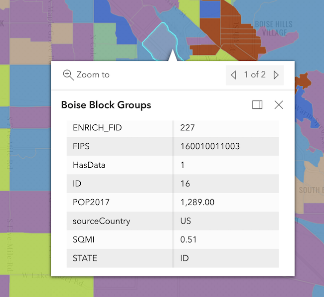
|
|
14
14
|
*
|
|
15
15
|
* @since 4.16
|
|
16
16
|
* @see [Sample - Generate a predominance visualization](https://developers.arcgis.com/javascript/latest/sample-code/visualization-sm-predominance/)
|
|
@@ -60,8 +60,8 @@ export interface FlowRendererParameters extends RasterRendererParameters {
|
|
|
60
60
|
* Possible values are listed below.
|
|
61
61
|
* | Value | Description | Example |
|
|
62
62
|
* | ----- | ----------- | ------- |
|
|
63
|
-
* | flow-line | Renders the uv and magnitude data as animated flow lines. This is ideal for representing wind and other atmospheric data. |  |
|
|
64
|
+
* | wave-front | Renders UV and magnitude data in a wave-like animation. This theme works well for ocean data. |  |
|
|
65
65
|
*
|
|
66
66
|
* > [!WARNING]
|
|
67
67
|
* >
|
|
@@ -394,12 +394,12 @@ export interface VisualVariableParametersBase extends AbortOptions {
|
|
|
394
394
|
* Possible values are listed below.
|
|
395
395
|
* | Value | Description | Example |
|
|
396
396
|
* | ----- | ----------- | ------- |
|
|
397
|
-
* | high-to-low | High values are emphasized with strong colors. The data values above one standard deviation from the mean are assigned the strongest color. Data values below one standard deviation from the mean are assigned the weakest color. All other values are interpolated. |  are visualized with weak colors while other values are emphasized with strong colors. All other values are interpolated. |  are emphasized with strong colors while other values are visualized with weak colors. All other values are interpolated. |  |
|
|
398
|
+
* | above | High values are emphasized with strong colors. The max data value is assigned the strongest color. The middle or average data value is assigned the weakest color. All other values are interpolated. |  |
|
|
399
|
+
* | below | Low values are emphasized with strong colors. The min data value is assigned the strongest color. The middle or average data value is assigned the weakest color. All other values are interpolated. |  |
|
|
400
|
+
* | above-and-below | Values centered on a meaningful data value (e.g. the average) are visualized with weak colors while other values are emphasized with strong colors. All other values are interpolated. | 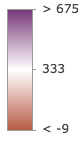 |
|
|
401
|
+
* | centered-on | Values centered on a meaningful data value (e.g. the average) are emphasized with strong colors while other values are visualized with weak colors. All other values are interpolated. |  |
|
|
402
|
+
* | extremes | High and low values are emphasized with strong colors. All others are visualized with weak colors. All other values are interpolated. |  |
|
|
403
403
|
*
|
|
404
404
|
* @default high-to-low
|
|
405
405
|
*/
|
|
@@ -947,12 +947,12 @@ export interface AgeRendererParameters extends AbortOptions {
|
|
|
947
947
|
* Possible values are listed below.
|
|
948
948
|
* | Value | Description | Example |
|
|
949
949
|
* | ----- | ----------- | ------- |
|
|
950
|
-
* | high-to-low | High values are emphasized with strong colors. The data values above one standard deviation from the mean are assigned the strongest color. Data values below one standard deviation from the mean are assigned the weakest color. All other values are interpolated. |  are visualized with weak colors while other values are emphasized with strong colors. All other values are interpolated. |  are emphasized with strong colors while other values are visualized with weak colors. All other values are interpolated. |  |
|
|
951
|
+
* | above | High values are emphasized with strong colors. The max data value is assigned the strongest color. The middle or average data value is assigned the weakest color. All other values are interpolated. |  |
|
|
952
|
+
* | below | Low values are emphasized with strong colors. The min data value is assigned the strongest color. The middle or average data value is assigned the weakest color. All other values are interpolated. |  |
|
|
953
|
+
* | above-and-below | Values centered on a meaningful data value (e.g. the average) are visualized with weak colors while other values are emphasized with strong colors. All other values are interpolated. |  |
|
|
954
|
+
* | centered-on | Values centered on a meaningful data value (e.g. the average) are emphasized with strong colors while other values are visualized with weak colors. All other values are interpolated. |  |
|
|
955
|
+
* | extremes | High and low values are emphasized with strong colors. All others are visualized with weak colors. All other values are interpolated. |  |
|
|
956
956
|
*
|
|
957
957
|
* @default high-to-low
|
|
958
958
|
*/
|