@arcgis/map-components 4.34.0-next.126 → 4.34.0-next.128
This diff represents the content of publicly available package versions that have been released to one of the supported registries. The information contained in this diff is provided for informational purposes only and reflects changes between package versions as they appear in their respective public registries.
- package/dist/cdn/{ET5C5YMY.js → 2ECBWCO2.js} +2 -2
- package/dist/cdn/{5AOHIN4B.js → 2H3XO7CN.js} +2 -2
- package/dist/cdn/{EVTMUQHE.js → 2H6QPPKV.js} +2 -2
- package/dist/cdn/2OUPGH3T.js +4 -0
- package/dist/cdn/{HDT5PZG6.js → 2U23PR2Z.js} +2 -2
- package/dist/cdn/{XMNRYHBV.js → 37SGC6JO.js} +2 -2
- package/dist/cdn/{CJPUFBD2.js → 3H5CGF2W.js} +2 -2
- package/dist/cdn/3TYD7MXA.js +4 -0
- package/dist/cdn/3XJLVWBC.js +4 -0
- package/dist/cdn/3Y6MSDPY.js +4 -0
- package/dist/cdn/{B75V53DG.js → 4EMGEB6M.js} +2 -2
- package/dist/cdn/{J5GNLGGY.js → 4YNGM73K.js} +2 -2
- package/dist/cdn/54WC2T2L.js +4 -0
- package/dist/cdn/{7WVBB25Q.js → 54YUDXEI.js} +2 -2
- package/dist/cdn/{RWFNVRUB.js → 5BH6C35G.js} +2 -2
- package/dist/cdn/5KMO7TRX.js +4 -0
- package/dist/cdn/{G3D6GHQ5.js → 5NDNY4PP.js} +2 -2
- package/dist/cdn/{47R2YESS.js → 5PGYUSRZ.js} +2 -2
- package/dist/cdn/{77RD2G3G.js → 5SKPSGZO.js} +2 -2
- package/dist/cdn/{HOIXT45X.js → 5V37ZOQL.js} +2 -2
- package/dist/cdn/5WO6TN2Z.js +4 -0
- package/dist/cdn/{HZK7BFEU.js → 62EOE6VY.js} +2 -2
- package/dist/cdn/{KOESCJOX.js → 62VYTKLK.js} +2 -2
- package/dist/cdn/{QRHJHPGM.js → 66UDJ2TB.js} +1 -1
- package/dist/cdn/{3FDYCN6J.js → 6C2FFQO2.js} +2 -2
- package/dist/cdn/{2CGCEJBW.js → 6CWVQ6UR.js} +2 -2
- package/dist/cdn/{ROAVA4JA.js → 6LHSMDAL.js} +2 -2
- package/dist/cdn/{55LQBMWX.js → 6LNLTFMY.js} +2 -2
- package/dist/cdn/{5IUQW4SV.js → 6LRAALBX.js} +2 -2
- package/dist/cdn/{PEGWYXKX.js → 6SFA2TBD.js} +2 -2
- package/dist/cdn/6UQYYNES.js +4 -0
- package/dist/cdn/{VZWI77C2.js → 727FOAJC.js} +2 -2
- package/dist/cdn/{Q4S3OBXP.js → 7DB6DUCJ.js} +2 -2
- package/dist/cdn/{RE6RPEK5.js → 7EVEBQOO.js} +1 -1
- package/dist/cdn/{2GU64EYX.js → 7J34FORW.js} +2 -2
- package/dist/cdn/{ZFIZ5ICA.js → 7KGDRCGZ.js} +2 -2
- package/dist/cdn/{VLIGGVPB.js → 7OENE6ZM.js} +2 -2
- package/dist/cdn/{UJIAE77U.js → 7RZWYNDZ.js} +2 -2
- package/dist/cdn/A4ICMR3Y.js +4 -0
- package/dist/cdn/{MGBURBCQ.js → A6FXBFIG.js} +2 -2
- package/dist/cdn/{4EN76RE4.js → AIBMTQIL.js} +2 -2
- package/dist/cdn/ALIRDKZL.js +4 -0
- package/dist/cdn/{SQXD3VUO.js → AXYL6UJQ.js} +2 -2
- package/dist/cdn/AYHLSBH3.js +4 -0
- package/dist/cdn/{3U6FL5CJ.js → BEFAFUTF.js} +2 -2
- package/dist/cdn/{CG7FTUAS.js → BFTQA6P5.js} +2 -2
- package/dist/cdn/{E6ZLK23H.js → BLZ7A4MO.js} +2 -2
- package/dist/cdn/{NNIA4NN4.js → BPX4DFYT.js} +2 -2
- package/dist/cdn/{RIUGYHZR.js → BXL3SOA7.js} +2 -2
- package/dist/cdn/{EF6JLI3D.js → CEH5AMZP.js} +2 -2
- package/dist/cdn/{LLZ4JQRB.js → CGR2JG6D.js} +1 -1
- package/dist/cdn/{F77QW2WG.js → CI5Y2Q6H.js} +2 -2
- package/dist/cdn/{AYOGHDI4.js → CMCJGWKJ.js} +2 -2
- package/dist/cdn/{6KQ5PJGC.js → CRKP4B32.js} +2 -2
- package/dist/cdn/{O5EP6F5A.js → CUHVMMFH.js} +2 -2
- package/dist/cdn/{GPF3LTPZ.js → CW2666RZ.js} +2 -2
- package/dist/cdn/{UTWATVD2.js → DI5YJ3E3.js} +2 -2
- package/dist/cdn/{HNIKYLKR.js → DJ44Q2JM.js} +1 -1
- package/dist/cdn/{T4SEIDZD.js → DMQERREH.js} +2 -2
- package/dist/cdn/{7JI7EN6Y.js → DNC4RW63.js} +2 -2
- package/dist/cdn/DR6PZOO4.js +4 -0
- package/dist/cdn/{MQJONABN.js → DRTV5TKW.js} +1 -1
- package/dist/cdn/{3FL3UVTV.js → DVNN7IFJ.js} +2 -2
- package/dist/cdn/{LCQ56ACM.js → DVT2QMCH.js} +2 -2
- package/dist/cdn/{GDSL5OPE.js → DXLAVJAL.js} +2 -2
- package/dist/cdn/{OPMS4BVQ.js → EDN4E7VX.js} +2 -2
- package/dist/cdn/{AZAVO3S5.js → EDZONWNW.js} +2 -2
- package/dist/cdn/{GMRQ63JW.js → EFJCUY4W.js} +2 -2
- package/dist/cdn/{RGUZMB66.js → ENTL7LUH.js} +2 -2
- package/dist/cdn/{RLVKJR7X.js → EPXWQERC.js} +2 -2
- package/dist/cdn/{XN5NVHQH.js → EZJRKL2Y.js} +2 -2
- package/dist/cdn/FA66GK4V.js +4 -0
- package/dist/cdn/FAJ6AS6Z.js +4 -0
- package/dist/cdn/{YEBVECU4.js → FGRYUWY4.js} +2 -2
- package/dist/cdn/{AP4U4PLQ.js → FNBJH4AX.js} +2 -2
- package/dist/cdn/{UQPLFS36.js → G4BGDKAH.js} +2 -2
- package/dist/cdn/{6JLRXIIU.js → GBZWFRT5.js} +2 -2
- package/dist/cdn/{B4KNVUPW.js → GF7XUPUG.js} +2 -2
- package/dist/cdn/{Y3R4IE5F.js → GHJY55KQ.js} +2 -2
- package/dist/cdn/{KJ3X6V5U.js → GKGDT535.js} +2 -2
- package/dist/cdn/{I6JLX5KC.js → GOLFULXL.js} +2 -2
- package/dist/cdn/{NJLNHW4X.js → GYWPHVHB.js} +2 -2
- package/dist/cdn/{Y7RX3V36.js → H3C7V4NF.js} +2 -2
- package/dist/cdn/{JSSGJ6QA.js → H4P4G25Z.js} +2 -2
- package/dist/cdn/{NOYXCWU2.js → HD6WVRXY.js} +2 -2
- package/dist/cdn/{DYDJ3Q4A.js → HJOWHWPI.js} +1 -1
- package/dist/cdn/{L2STTIN5.js → HLIF2MOX.js} +2 -2
- package/dist/cdn/{PLEDYCCT.js → HNTDZ7QS.js} +2 -2
- package/dist/cdn/{23BQVV5P.js → HQTXLNAM.js} +2 -2
- package/dist/cdn/{BG7GTNI2.js → I4RQS3XS.js} +2 -2
- package/dist/cdn/{6ZX64NK4.js → IFPTT4L5.js} +2 -2
- package/dist/cdn/{CEY2WMFN.js → IINDWWUN.js} +2 -2
- package/dist/cdn/{DEVI26PS.js → IKPHWLL7.js} +2 -2
- package/dist/cdn/{YHGAKCIU.js → IN32G4PC.js} +1 -1
- package/dist/cdn/{SNOMMY7T.js → INZGS6EI.js} +2 -2
- package/dist/cdn/{ZC65MIKC.js → IPQ6R5Z7.js} +2 -2
- package/dist/cdn/{RNZBGMVW.js → IRYI2C5T.js} +2 -2
- package/dist/cdn/{HTUJZ4JI.js → J6TGDZAG.js} +2 -2
- package/dist/cdn/{FWMIDJWL.js → JAU6IZNV.js} +2 -2
- package/dist/cdn/{7WQAAEMD.js → JJTJRWHU.js} +2 -2
- package/dist/cdn/{XIMT6CTV.js → JLNXFQR7.js} +2 -2
- package/dist/cdn/{XNNSC73G.js → JNUQB6QP.js} +2 -2
- package/dist/cdn/{KEXMSNPE.js → JRXBVEW7.js} +2 -2
- package/dist/cdn/{MKAIDDSL.js → K4C5QXH3.js} +2 -2
- package/dist/cdn/KBB4ZI2O.js +4 -0
- package/dist/cdn/{GPAKJWXM.js → KDSVA2B7.js} +2 -2
- package/dist/cdn/KHS3SWXG.js +4 -0
- package/dist/cdn/{NGQWSV2A.js → KNAS2HY5.js} +1 -1
- package/dist/cdn/{3IYQOLWN.js → KRKTWT35.js} +2 -2
- package/dist/cdn/{UYCCGEVR.js → KX7DGN5F.js} +2 -2
- package/dist/cdn/{YPZUH5O2.js → L2JAUAVY.js} +2 -2
- package/dist/cdn/{OQN4MGR3.js → L4OQNX5N.js} +1 -1
- package/dist/cdn/{5XH5ROO7.js → L7UBSVYJ.js} +2 -2
- package/dist/cdn/LAL3LRXS.js +4 -0
- package/dist/cdn/{T34X3YIQ.js → LDWFL552.js} +2 -2
- package/dist/cdn/{LXJSY2MG.js → LOUJDVKG.js} +2 -2
- package/dist/cdn/{MXPES5JI.js → LRD7NK6W.js} +2 -2
- package/dist/cdn/{FGWI3CKE.js → LUCLWH5K.js} +2 -2
- package/dist/cdn/{CGBOZKWZ.js → LYXF5RII.js} +2 -2
- package/dist/cdn/{AKSS4A7A.js → MBHMZBQQ.js} +1 -1
- package/dist/cdn/{YFFTG7AG.js → MGDAIXBC.js} +2 -2
- package/dist/cdn/{PPMKWYXP.js → MKE4XYAJ.js} +2 -2
- package/dist/cdn/{YKESPNAQ.js → MP4DJY5C.js} +2 -2
- package/dist/cdn/{TKHOLMKU.js → MQAAOELP.js} +2 -2
- package/dist/cdn/{EIFMWR4A.js → MWL2W7MK.js} +2 -2
- package/dist/cdn/{2MQGFPDR.js → MYEL4Y44.js} +2 -2
- package/dist/cdn/N4MXMJGO.js +4 -0
- package/dist/cdn/{VF4PKUB3.js → NRKJBQCD.js} +2 -2
- package/dist/cdn/{CAHDNHKE.js → NV23B34I.js} +2 -2
- package/dist/cdn/{UVZCPBXJ.js → NZDLPUF7.js} +2 -2
- package/dist/cdn/{NRFGE4OE.js → O32K44FO.js} +2 -2
- package/dist/cdn/{L4I2TX5J.js → O4MJ4QT5.js} +2 -2
- package/dist/cdn/{QIUGB7VY.js → OB6QBXC6.js} +2 -2
- package/dist/cdn/{IXIGZZPZ.js → OI5H3BL2.js} +2 -2
- package/dist/cdn/{F6W27ADX.js → OQHKBGAG.js} +2 -2
- package/dist/cdn/{3TYLLPJM.js → OS6SSKFR.js} +2 -2
- package/dist/cdn/OTAVYVFZ.js +4 -0
- package/dist/cdn/{QK7MQ3ZG.js → OV7FLXQK.js} +2 -2
- package/dist/cdn/{BMKCXLJG.js → OYCJFRBN.js} +2 -2
- package/dist/cdn/{P3PUOKVX.js → OZCL6R6M.js} +2 -2
- package/dist/cdn/{CG4XV6GU.js → OZL4Y6PI.js} +2 -2
- package/dist/cdn/P7EJRVNJ.js +4 -0
- package/dist/cdn/{7MIUNXKP.js → PPMLSRAL.js} +2 -2
- package/dist/cdn/{FUYBMKIT.js → PV6MXF7P.js} +2 -2
- package/dist/cdn/{N2RX23W6.js → PWWDMTGF.js} +2 -2
- package/dist/cdn/{NDJ4DLLV.js → Q3Q4VDPU.js} +2 -2
- package/dist/cdn/{ZFJ4HX7F.js → Q5JJF7JN.js} +2 -2
- package/dist/cdn/{OQXMPLC5.js → QDF36CXE.js} +2 -2
- package/dist/cdn/{GN3JIGKA.js → QGU4G2LK.js} +2 -2
- package/dist/cdn/{2SMHV525.js → QIYI4QWP.js} +2 -2
- package/dist/cdn/{AM7PEI2P.js → QOVGM25K.js} +2 -2
- package/dist/cdn/QQRBSWTG.js +4 -0
- package/dist/cdn/{DST4YOTP.js → QVOSBNB5.js} +2 -2
- package/dist/cdn/{VJMN4VGZ.js → R2YJ4VKL.js} +2 -2
- package/dist/cdn/{TRD5GIAV.js → R42VWPV7.js} +2 -2
- package/dist/cdn/{AHVQ4H5J.js → RGOWUXWS.js} +2 -2
- package/dist/cdn/{47M5YVES.js → RGZDXD5H.js} +1 -1
- package/dist/cdn/{HWBX65BI.js → RTC37Y5W.js} +2 -2
- package/dist/cdn/{W3CTD2JA.js → RVR3KJDU.js} +2 -2
- package/dist/cdn/{JBMNZ72D.js → RXPZPX4D.js} +2 -2
- package/dist/cdn/S4PMWJSR.js +4 -0
- package/dist/cdn/{FLBPJTU5.js → SAHQV77E.js} +2 -2
- package/dist/cdn/{FAUOLDED.js → SK65SOQI.js} +2 -2
- package/dist/cdn/{BUTNMXZP.js → SMDIWIPV.js} +2 -2
- package/dist/cdn/{F2K7AF6Z.js → SWY2HN6J.js} +2 -2
- package/dist/cdn/{JA5JM23Q.js → T5HWMNIT.js} +2 -2
- package/dist/cdn/{CSVVFUUC.js → THNVOXBQ.js} +2 -2
- package/dist/cdn/THZWI5UZ.js +4 -0
- package/dist/cdn/{Q2WV5SS7.js → TINFHRAM.js} +1 -1
- package/dist/cdn/{QDGMQESG.js → TKB5EQJG.js} +2 -2
- package/dist/cdn/{CHGLN22H.js → TLMJYYUH.js} +2 -2
- package/dist/cdn/{23CPOPYJ.js → TO76MUXW.js} +2 -2
- package/dist/cdn/{OSA6ZGPX.js → TPLNN22C.js} +2 -2
- package/dist/cdn/{2564ALYI.js → TRCE2UD4.js} +2 -2
- package/dist/cdn/{LSQE3IAM.js → TVG544VC.js} +2 -2
- package/dist/cdn/{7WK7MWXY.js → UAYBOFPS.js} +2 -2
- package/dist/cdn/UBPY57H7.js +5 -0
- package/dist/cdn/{4CPB32NP.js → UCTEISBH.js} +2 -2
- package/dist/cdn/{I43WLH4Q.js → UGZTTEAN.js} +2 -2
- package/dist/cdn/{3RCKMIZG.js → UJB6XFFE.js} +2 -2
- package/dist/cdn/{EPGOIJ36.js → V2C7SG42.js} +2 -2
- package/dist/cdn/{XF3IRPXR.js → V3ZZOWOZ.js} +2 -2
- package/dist/cdn/V453Q5SF.js +4 -0
- package/dist/cdn/{YPXIGB3R.js → V635Q4AX.js} +2 -2
- package/dist/cdn/{XBW42KLF.js → VB5UXWAE.js} +2 -2
- package/dist/cdn/{ABY74RTP.js → VC6HWBIL.js} +2 -2
- package/dist/cdn/{A6U7FTEU.js → VNYNALS7.js} +2 -2
- package/dist/cdn/{HDNJM2LD.js → VQMB3CD5.js} +2 -2
- package/dist/cdn/{NU4AD74P.js → VUT6XGHU.js} +2 -2
- package/dist/cdn/{DGHKDLTH.js → VZGNVDRD.js} +2 -2
- package/dist/cdn/{62TLIOD4.js → W5LV6KJQ.js} +2 -2
- package/dist/cdn/{7TTV5PFB.js → W6EGVMM4.js} +2 -2
- package/dist/cdn/{XA3CG5EP.js → WDRSWYAT.js} +2 -2
- package/dist/cdn/{RLW2HWUC.js → WRCKK4JT.js} +2 -2
- package/dist/cdn/{FGJVMKGG.js → WS44MNJS.js} +2 -2
- package/dist/cdn/{T7CO6LBD.js → WYIGBP6C.js} +2 -2
- package/dist/cdn/{T7324YLA.js → X5SAGX4O.js} +2 -2
- package/dist/cdn/X64RV363.js +4 -0
- package/dist/cdn/{Z3PGZKSN.js → X77TSJNR.js} +2 -2
- package/dist/cdn/XCKNQRIC.js +4 -0
- package/dist/cdn/{U456XBFI.js → Y4DGIKUB.js} +2 -2
- package/dist/cdn/{O6LHXWZW.js → YGR6QLX5.js} +2 -2
- package/dist/cdn/YHGSE3BM.js +4 -0
- package/dist/cdn/YTWAF4LD.js +4 -0
- package/dist/cdn/{W6XGDNMY.js → Z534ORPK.js} +2 -2
- package/dist/cdn/{HDHMKQII.js → Z5MROVYA.js} +1 -1
- package/dist/cdn/{WCAX4RU7.js → ZA46SSTL.js} +2 -2
- package/dist/cdn/ZB65AVDQ.js +4 -0
- package/dist/cdn/{AVFUK3B2.js → ZGY5YA4V.js} +2 -2
- package/dist/cdn/{OTELWF7N.js → ZHTQNBPM.js} +2 -2
- package/dist/cdn/{EGNVJKZ5.js → ZNFBOSZA.js} +2 -2
- package/dist/cdn/{IDUBBWVQ.js → ZNOVB4YO.js} +2 -2
- package/dist/cdn/{JG654ASN.js → ZVGMRQCQ.js} +2 -2
- package/dist/cdn/{M73G7Y5Z.js → ZVI6TJKU.js} +2 -2
- package/dist/cdn/assets/popup/t9n/messages.ar.json +1 -0
- package/dist/cdn/assets/popup/t9n/messages.bg.json +1 -0
- package/dist/cdn/assets/popup/t9n/messages.bs.json +1 -0
- package/dist/cdn/assets/popup/t9n/messages.ca.json +1 -0
- package/dist/cdn/assets/popup/t9n/messages.cs.json +1 -0
- package/dist/cdn/assets/popup/t9n/messages.da.json +1 -0
- package/dist/cdn/assets/popup/t9n/messages.de.json +1 -0
- package/dist/cdn/assets/popup/t9n/messages.el.json +1 -0
- package/dist/cdn/assets/popup/t9n/messages.en.json +1 -0
- package/dist/cdn/assets/popup/t9n/messages.es.json +1 -0
- package/dist/cdn/assets/popup/t9n/messages.et.json +1 -0
- package/dist/cdn/assets/popup/t9n/messages.fi.json +1 -0
- package/dist/cdn/assets/popup/t9n/messages.fr.json +1 -0
- package/dist/cdn/assets/popup/t9n/messages.he.json +1 -0
- package/dist/cdn/assets/popup/t9n/messages.hr.json +1 -0
- package/dist/cdn/assets/popup/t9n/messages.hu.json +1 -0
- package/dist/cdn/assets/popup/t9n/messages.id.json +1 -0
- package/dist/cdn/assets/popup/t9n/messages.it.json +1 -0
- package/dist/cdn/assets/popup/t9n/messages.ja.json +1 -0
- package/dist/cdn/assets/popup/t9n/messages.ko.json +1 -0
- package/dist/cdn/assets/popup/t9n/messages.lt.json +1 -0
- package/dist/cdn/assets/popup/t9n/messages.lv.json +1 -0
- package/dist/cdn/assets/popup/t9n/messages.nl.json +1 -0
- package/dist/cdn/assets/popup/t9n/messages.no.json +1 -0
- package/dist/cdn/assets/popup/t9n/messages.pl.json +1 -0
- package/dist/cdn/assets/popup/t9n/messages.pt-BR.json +1 -0
- package/dist/cdn/assets/popup/t9n/messages.pt-PT.json +1 -0
- package/dist/cdn/assets/popup/t9n/messages.ro.json +1 -0
- package/dist/cdn/assets/popup/t9n/messages.ru.json +1 -0
- package/dist/cdn/assets/popup/t9n/messages.sk.json +1 -0
- package/dist/cdn/assets/popup/t9n/messages.sl.json +1 -0
- package/dist/cdn/assets/popup/t9n/messages.sr.json +1 -0
- package/dist/cdn/assets/popup/t9n/messages.sv.json +1 -0
- package/dist/cdn/assets/popup/t9n/messages.th.json +1 -0
- package/dist/cdn/assets/popup/t9n/messages.tr.json +1 -0
- package/dist/cdn/assets/popup/t9n/messages.uk.json +1 -0
- package/dist/cdn/assets/popup/t9n/messages.vi.json +1 -0
- package/dist/cdn/assets/popup/t9n/messages.zh-CN.json +1 -0
- package/dist/cdn/assets/popup/t9n/messages.zh-HK.json +1 -0
- package/dist/cdn/assets/popup/t9n/messages.zh-TW.json +1 -0
- package/dist/cdn/index.js +2 -2
- package/dist/cdn/main.css +1 -1
- package/dist/chunks/AnalysisViewModel.js +1 -1
- package/dist/chunks/action-utils.js +1 -1
- package/dist/chunks/async-utils.js +1 -1
- package/dist/chunks/basemap-gallery-resources.js +1 -1
- package/dist/chunks/chart-utils.js +1 -1
- package/dist/chunks/chartCommon.js +1 -1
- package/dist/chunks/component-utils.js +1 -1
- package/dist/chunks/createCloseEvent.js +1 -1
- package/dist/chunks/{slots2.js → esri-main.js} +2 -3
- package/dist/chunks/feature-utils.js +1 -1
- package/dist/chunks/globalCss.js +1 -1
- package/dist/chunks/heading.js +1 -1
- package/dist/chunks/layer-list.js +1 -1
- package/dist/chunks/legacyIcon.js +1 -1
- package/dist/chunks/maybe.js +1 -1
- package/dist/chunks/measurementUtils.js +1 -1
- package/dist/chunks/runtime.js +1 -1
- package/dist/chunks/screenLocation.js +34 -0
- package/dist/chunks/slots.js +27 -25
- package/dist/chunks/svgUtils.js +1 -1
- package/dist/chunks/titleUtils.js +1 -1
- package/dist/chunks/univariateUtils.js +1 -1
- package/dist/chunks/useHandles.js +1 -1
- package/dist/chunks/useT9n.js +1 -1
- package/dist/chunks/useView.js +22 -43
- package/dist/chunks/useViewModel.js +1 -1
- package/dist/chunks/useWidget.js +1 -1
- package/dist/chunks/utils.js +1 -1
- package/dist/chunks/utils2.js +1 -1
- package/dist/components/arcgis-area-measurement-2d/customElement.d.ts +10 -4
- package/dist/components/arcgis-area-measurement-2d/customElement.js +3 -3
- package/dist/components/arcgis-area-measurement-3d/customElement.d.ts +3 -0
- package/dist/components/arcgis-area-measurement-3d/customElement.js +7 -7
- package/dist/components/arcgis-attachments/customElement.d.ts +1 -1
- package/dist/components/arcgis-attachments/customElement.js +1 -1
- package/dist/components/arcgis-basemap-gallery/customElement.d.ts +8 -0
- package/dist/components/arcgis-basemap-gallery/customElement.js +7 -7
- package/dist/components/arcgis-basemap-gallery-item/customElement.js +1 -1
- package/dist/components/arcgis-basemap-layer-list/customElement.d.ts +9 -1
- package/dist/components/arcgis-basemap-layer-list/customElement.js +3 -3
- package/dist/components/arcgis-basemap-toggle/customElement.d.ts +8 -0
- package/dist/components/arcgis-basemap-toggle/customElement.js +3 -3
- package/dist/components/arcgis-bookmarks/customElement.d.ts +6 -0
- package/dist/components/arcgis-bookmarks/customElement.js +3 -3
- package/dist/components/arcgis-building-explorer/customElement.d.ts +9 -1
- package/dist/components/arcgis-building-explorer/customElement.js +3 -3
- package/dist/components/arcgis-catalog-layer-list/customElement.d.ts +11 -1
- package/dist/components/arcgis-catalog-layer-list/customElement.js +3 -3
- package/dist/components/arcgis-compass/customElement.d.ts +10 -1
- package/dist/components/arcgis-compass/customElement.js +6 -6
- package/dist/components/arcgis-coordinate-conversion/customElement.d.ts +10 -2
- package/dist/components/arcgis-coordinate-conversion/customElement.js +3 -3
- package/dist/components/arcgis-daylight/customElement.d.ts +3 -0
- package/dist/components/arcgis-daylight/customElement.js +4 -4
- package/dist/components/arcgis-direct-line-measurement-3d/customElement.d.ts +3 -0
- package/dist/components/arcgis-direct-line-measurement-3d/customElement.js +3 -3
- package/dist/components/arcgis-directional-pad/customElement.d.ts +8 -0
- package/dist/components/arcgis-directional-pad/customElement.js +7 -7
- package/dist/components/arcgis-directions/customElement.d.ts +10 -2
- package/dist/components/arcgis-directions/customElement.js +3 -3
- package/dist/components/arcgis-distance-measurement-2d/customElement.d.ts +9 -1
- package/dist/components/arcgis-distance-measurement-2d/customElement.js +3 -3
- package/dist/components/arcgis-editor/customElement.d.ts +9 -1
- package/dist/components/arcgis-editor/customElement.js +3 -3
- package/dist/components/arcgis-elevation-profile/customElement.d.ts +9 -1
- package/dist/components/arcgis-elevation-profile/customElement.js +3 -3
- package/dist/components/arcgis-elevation-profile-legend/customElement.js +1 -1
- package/dist/components/arcgis-elevation-profile-legend-item/customElement.js +1 -1
- package/dist/components/arcgis-elevation-profile-next/customElement.d.ts +1 -0
- package/dist/components/arcgis-elevation-profile-next/customElement.js +9 -9
- package/dist/components/arcgis-elevation-profile-settings/customElement.js +1 -1
- package/dist/components/arcgis-elevation-profile-statistics/customElement.js +1 -1
- package/dist/components/arcgis-expand/customElement.d.ts +8 -0
- package/dist/components/arcgis-expand/customElement.js +31 -31
- package/dist/components/arcgis-feature/customElement.d.ts +10 -8
- package/dist/components/arcgis-feature/customElement.js +17 -17
- package/dist/components/arcgis-feature-attachments/customElement.js +1 -1
- package/dist/components/arcgis-feature-content/customElement.js +6 -6
- package/dist/components/arcgis-feature-element-info/customElement.js +10 -10
- package/dist/components/arcgis-feature-expression/customElement.js +1 -1
- package/dist/components/arcgis-feature-fields/customElement.js +10 -10
- package/dist/components/arcgis-feature-form/customElement.d.ts +1 -1
- package/dist/components/arcgis-feature-form/customElement.js +1 -1
- package/dist/components/arcgis-feature-media/customElement.js +45 -49
- package/dist/components/arcgis-feature-relationship/customElement.js +1 -1
- package/dist/components/arcgis-feature-table/customElement.d.ts +9 -1
- package/dist/components/arcgis-feature-table/customElement.js +3 -3
- package/dist/components/arcgis-feature-templates/customElement.d.ts +1 -1
- package/dist/components/arcgis-feature-templates/customElement.js +1 -1
- package/dist/components/arcgis-features/customElement.d.ts +64 -34
- package/dist/components/arcgis-features/customElement.js +79 -79
- package/dist/components/arcgis-floor-filter/customElement.d.ts +10 -4
- package/dist/components/arcgis-floor-filter/customElement.js +3 -3
- package/dist/components/arcgis-fullscreen/customElement.d.ts +4 -1
- package/dist/components/arcgis-fullscreen/customElement.js +6 -6
- package/dist/components/arcgis-grid-controls/customElement.d.ts +6 -0
- package/dist/components/arcgis-grid-controls/customElement.js +3 -3
- package/dist/components/arcgis-histogram-range-slider/customElement.d.ts +1 -1
- package/dist/components/arcgis-histogram-range-slider/customElement.js +1 -1
- package/dist/components/arcgis-home/customElement.d.ts +7 -0
- package/dist/components/arcgis-home/customElement.js +13 -13
- package/dist/components/arcgis-labeled-switch/customElement.js +1 -1
- package/dist/components/arcgis-layer-list/customElement.d.ts +11 -1
- package/dist/components/arcgis-layer-list/customElement.js +3 -3
- package/dist/components/arcgis-layer-list-item/customElement.js +1 -1
- package/dist/components/arcgis-legend/customElement.d.ts +216 -60
- package/dist/components/arcgis-legend/customElement.js +10 -10
- package/dist/components/arcgis-legend-card-color-ramp/customElement.d.ts +1 -1
- package/dist/components/arcgis-legend-card-color-ramp/customElement.js +1 -1
- package/dist/components/arcgis-legend-card-element/customElement.d.ts +1 -1
- package/dist/components/arcgis-legend-card-element/customElement.js +1 -1
- package/dist/components/arcgis-legend-card-size-ramp/customElement.d.ts +1 -1
- package/dist/components/arcgis-legend-card-size-ramp/customElement.js +1 -1
- package/dist/components/arcgis-legend-card-univariate-above-and-below-ramp/customElement.d.ts +1 -1
- package/dist/components/arcgis-legend-card-univariate-above-and-below-ramp/customElement.js +1 -1
- package/dist/components/arcgis-legend-card-univariate-color-size-ramp/customElement.d.ts +1 -1
- package/dist/components/arcgis-legend-card-univariate-color-size-ramp/customElement.js +1 -1
- package/dist/components/arcgis-legend-card-view/customElement.d.ts +1 -1
- package/dist/components/arcgis-legend-card-view/customElement.js +1 -1
- package/dist/components/arcgis-legend-classic-color-ramp/customElement.d.ts +1 -1
- package/dist/components/arcgis-legend-classic-color-ramp/customElement.js +1 -1
- package/dist/components/arcgis-legend-classic-element/customElement.d.ts +1 -1
- package/dist/components/arcgis-legend-classic-element/customElement.js +1 -1
- package/dist/components/arcgis-legend-classic-size-ramp/customElement.d.ts +1 -1
- package/dist/components/arcgis-legend-classic-size-ramp/customElement.js +1 -1
- package/dist/components/arcgis-legend-classic-univariate-above-and-below-ramp/customElement.d.ts +1 -1
- package/dist/components/arcgis-legend-classic-univariate-above-and-below-ramp/customElement.js +1 -1
- package/dist/components/arcgis-legend-classic-univariate-color-size-ramp/customElement.d.ts +1 -1
- package/dist/components/arcgis-legend-classic-univariate-color-size-ramp/customElement.js +1 -1
- package/dist/components/arcgis-legend-classic-view/customElement.d.ts +1 -1
- package/dist/components/arcgis-legend-classic-view/customElement.js +1 -1
- package/dist/components/arcgis-legend-relationship-ramp/customElement.d.ts +1 -1
- package/dist/components/arcgis-legend-relationship-ramp/customElement.js +1 -1
- package/dist/components/arcgis-legend-spike-ramp/customElement.d.ts +1 -1
- package/dist/components/arcgis-legend-spike-ramp/customElement.js +1 -1
- package/dist/components/arcgis-line-of-sight/customElement.d.ts +3 -0
- package/dist/components/arcgis-line-of-sight/customElement.js +2 -2
- package/dist/components/arcgis-link-chart/customElement.d.ts +1 -1
- package/dist/components/arcgis-link-chart/customElement.js +8 -8
- package/dist/components/arcgis-link-chart-layout-switcher/customElement.d.ts +8 -1
- package/dist/components/arcgis-link-chart-layout-switcher/customElement.js +3 -3
- package/dist/components/arcgis-locate/customElement.d.ts +4 -0
- package/dist/components/arcgis-locate/customElement.js +9 -9
- package/dist/components/arcgis-map/customElement.d.ts +3 -2
- package/dist/components/arcgis-map/customElement.js +19 -19
- package/dist/components/arcgis-measurement/customElement.d.ts +8 -4
- package/dist/components/arcgis-measurement/customElement.js +3 -3
- package/dist/components/arcgis-measurement-content/customElement.js +1 -1
- package/dist/components/arcgis-navigation-toggle/customElement.d.ts +3 -0
- package/dist/components/arcgis-navigation-toggle/customElement.js +3 -3
- package/dist/components/arcgis-oriented-imagery-viewer/customElement.d.ts +9 -1
- package/dist/components/arcgis-oriented-imagery-viewer/customElement.js +9 -9
- package/dist/components/arcgis-placement/customElement.d.ts +3 -1
- package/dist/components/arcgis-placement/customElement.js +11 -10
- package/dist/components/arcgis-popup/css.d.ts +31 -0
- package/dist/components/arcgis-popup/customElement.d.ts +651 -0
- package/dist/components/arcgis-popup/customElement.js +393 -0
- package/dist/components/arcgis-popup/index.d.ts +2 -0
- package/dist/components/arcgis-popup/index.js +2 -0
- package/dist/components/arcgis-popup/interfaces.d.ts +43 -0
- package/dist/components/arcgis-print/customElement.d.ts +8 -0
- package/dist/components/arcgis-print/customElement.js +3 -3
- package/dist/components/arcgis-print-custom-text-elements/customElement.js +1 -1
- package/dist/components/arcgis-print-dpi-input/customElement.js +1 -1
- package/dist/components/arcgis-print-export-button/customElement.js +1 -1
- package/dist/components/arcgis-print-exported-link/customElement.js +1 -1
- package/dist/components/arcgis-print-exports-panel/customElement.js +1 -1
- package/dist/components/arcgis-print-format-select/customElement.js +1 -1
- package/dist/components/arcgis-print-layout-advanced-options/customElement.js +1 -1
- package/dist/components/arcgis-print-layout-panel/customElement.js +1 -1
- package/dist/components/arcgis-print-main-panel/customElement.js +1 -1
- package/dist/components/arcgis-print-map-only-advanced-options/customElement.js +1 -1
- package/dist/components/arcgis-print-map-only-panel/customElement.js +1 -1
- package/dist/components/arcgis-print-out-spatial-reference-input/customElement.js +1 -1
- package/dist/components/arcgis-print-preview-input/customElement.js +1 -1
- package/dist/components/arcgis-print-scale-section/customElement.js +1 -1
- package/dist/components/arcgis-print-template-select/customElement.js +1 -1
- package/dist/components/arcgis-print-template-selector/customElement.js +1 -1
- package/dist/components/arcgis-result-feature-list/customElement.js +1 -1
- package/dist/components/arcgis-scale-bar/customElement.d.ts +8 -0
- package/dist/components/arcgis-scale-bar/customElement.js +9 -9
- package/dist/components/arcgis-scale-range-slider/customElement.d.ts +9 -1
- package/dist/components/arcgis-scale-range-slider/customElement.js +3 -3
- package/dist/components/arcgis-scene/customElement.d.ts +2 -1
- package/dist/components/arcgis-scene/customElement.js +10 -10
- package/dist/components/arcgis-search/customElement.d.ts +10 -0
- package/dist/components/arcgis-search/customElement.js +3 -3
- package/dist/components/arcgis-search-result-renderer/customElement.js +1 -1
- package/dist/components/arcgis-shadow-cast/customElement.d.ts +9 -1
- package/dist/components/arcgis-shadow-cast/customElement.js +3 -3
- package/dist/components/arcgis-sketch/customElement.d.ts +10 -2
- package/dist/components/arcgis-sketch/customElement.js +3 -3
- package/dist/components/arcgis-slice/customElement.d.ts +2 -0
- package/dist/components/arcgis-slice/customElement.js +7 -7
- package/dist/components/arcgis-spinner/customElement.js +18 -44
- package/dist/components/arcgis-swipe/customElement.d.ts +8 -0
- package/dist/components/arcgis-swipe/customElement.js +3 -3
- package/dist/components/arcgis-table-list/customElement.d.ts +3 -1
- package/dist/components/arcgis-table-list/customElement.js +1 -1
- package/dist/components/arcgis-time-slider/customElement.d.ts +9 -1
- package/dist/components/arcgis-time-slider/customElement.js +3 -3
- package/dist/components/arcgis-time-zone-label/customElement.d.ts +2 -0
- package/dist/components/arcgis-time-zone-label/customElement.js +1 -1
- package/dist/components/arcgis-track/customElement.d.ts +8 -0
- package/dist/components/arcgis-track/customElement.js +10 -10
- package/dist/components/arcgis-unit-select/customElement.js +1 -1
- package/dist/components/arcgis-utility-network-associations/customElement.d.ts +10 -2
- package/dist/components/arcgis-utility-network-associations/customElement.js +3 -3
- package/dist/components/arcgis-utility-network-trace/customElement.d.ts +9 -1
- package/dist/components/arcgis-utility-network-trace/customElement.js +3 -3
- package/dist/components/arcgis-utility-network-trace-analysis/customElement.js +1 -1
- package/dist/components/arcgis-utility-network-validate-topology/customElement.d.ts +15 -3
- package/dist/components/arcgis-utility-network-validate-topology/customElement.js +3 -3
- package/dist/components/arcgis-value-picker/customElement.d.ts +1 -1
- package/dist/components/arcgis-value-picker/customElement.js +1 -1
- package/dist/components/arcgis-version-management/customElement.d.ts +2 -0
- package/dist/components/arcgis-version-management/customElement.js +1 -1
- package/dist/components/arcgis-version-management-service-item/customElement.js +1 -1
- package/dist/components/arcgis-version-management-version-item/customElement.js +1 -1
- package/dist/components/arcgis-version-management-version-list/customElement.js +1 -1
- package/dist/components/arcgis-version-management-version-properties/customElement.js +1 -1
- package/dist/components/arcgis-video/customElement.js +5 -5
- package/dist/components/arcgis-video-player/customElement.js +1 -1
- package/dist/components/arcgis-video-player-action-bar/customElement.js +1 -1
- package/dist/components/arcgis-video-player-actions-group/customElement.js +1 -1
- package/dist/components/arcgis-video-player-controls-group/customElement.js +1 -1
- package/dist/components/arcgis-video-player-metadata/customElement.js +1 -1
- package/dist/components/arcgis-video-player-settings/customElement.js +1 -1
- package/dist/components/arcgis-video-player-slider/customElement.js +1 -1
- package/dist/components/arcgis-weather/customElement.d.ts +3 -0
- package/dist/components/arcgis-weather/customElement.js +49 -49
- package/dist/components/arcgis-zoom/customElement.d.ts +3 -0
- package/dist/components/arcgis-zoom/customElement.js +7 -7
- package/dist/controllers/useWidget.d.ts +1 -1
- package/dist/docs/api.json +8642 -7163
- package/dist/docs/docs.json +7777 -6358
- package/dist/docs/vscode.css-custom-data.json +66 -1
- package/dist/docs/vscode.html-custom-data.json +248 -342
- package/dist/docs/web-types.json +1433 -1172
- package/dist/index.d.ts +23 -70
- package/dist/index.js +1 -1
- package/dist/loader.js +55 -54
- package/dist/types/lumina.d.ts +61 -121
- package/dist/types/preact.d.ts +62 -135
- package/dist/types/react.d.ts +63 -149
- package/dist/types/stencil.d.ts +61 -121
- package/package.json +3 -3
- package/dist/cdn/2OEJGJTN.js +0 -4
- package/dist/cdn/37IXK3LX.js +0 -4
- package/dist/cdn/4ARAQPEK.js +0 -4
- package/dist/cdn/4GPP7ZG2.js +0 -4
- package/dist/cdn/5PGLNF5F.js +0 -4
- package/dist/cdn/66LROTMP.js +0 -5
- package/dist/cdn/6IHB7OVK.js +0 -4
- package/dist/cdn/6VKN7ZIV.js +0 -4
- package/dist/cdn/C7WOKMZX.js +0 -4
- package/dist/cdn/CQLUVA4A.js +0 -4
- package/dist/cdn/E3UPPRG5.js +0 -4
- package/dist/cdn/EVODZEOK.js +0 -4
- package/dist/cdn/FY7YUBGD.js +0 -4
- package/dist/cdn/GWLTZFSG.js +0 -4
- package/dist/cdn/H75OPTHT.js +0 -4
- package/dist/cdn/HHFIZ3CL.js +0 -4
- package/dist/cdn/JF6JKWM6.js +0 -4
- package/dist/cdn/KLYV2SZX.js +0 -4
- package/dist/cdn/KRWQCBAZ.js +0 -4
- package/dist/cdn/KVVUQQUC.js +0 -4
- package/dist/cdn/LDIYHILE.js +0 -4
- package/dist/cdn/NV2NHBFO.js +0 -4
- package/dist/cdn/Q257PG2M.js +0 -4
- package/dist/cdn/RGYQV5XB.js +0 -4
- package/dist/cdn/SG22KYCL.js +0 -4
- package/dist/cdn/T6EQEVD2.js +0 -4
- package/dist/cdn/UI4GQIIT.js +0 -4
- package/dist/cdn/XZOIOZ43.js +0 -4
|
@@ -1,14 +1,89 @@
|
|
|
1
1
|
/// <reference types="@arcgis/core/interfaces.d.ts" />
|
|
2
2
|
/// <reference path="../../index.d.ts" />
|
|
3
3
|
import { default as LegendViewModel } from '@arcgis/core/widgets/Legend/LegendViewModel.js';
|
|
4
|
-
import { JsxNode,
|
|
4
|
+
import { JsxNode, PublicLitElement as LitElement, TargetedEvent } from '@arcgis/lumina';
|
|
5
5
|
import { Use } from '@arcgis/lumina/controllers';
|
|
6
6
|
import { HeadingLevel } from '../../support/heading';
|
|
7
7
|
import { ArcgisReferenceElement } from '../../utils/component-utils';
|
|
8
8
|
|
|
9
9
|
declare const useLegendViewModel: (component: LitElement & Pick<LegendViewModel, never> & import('../../controllers/useViewModel').ViewModelControllerUses<LegendViewModel>) => LegendViewModel;
|
|
10
|
-
/**
|
|
10
|
+
/**
|
|
11
|
+
* The Legend component displays the symbols and labels used to represent layers in a [arcgis-map](https://developers.arcgis.com/javascript/latest/references/map-components/arcgis-map/) or [arcgis-scene](https://developers.arcgis.com/javascript/latest/references/map-components/arcgis-scene/).
|
|
12
|
+
* Only layers and sublayers visible in the view are shown, unless [ignoreLayerVisibility](https://developers.arcgis.com/javascript/latest/references/map-components/arcgis-legend/#ignoreLayerVisibility) is set to `true`.
|
|
13
|
+
*
|
|
14
|
+
* The legend automatically updates when:
|
|
15
|
+
* - the visibility of a layer or sublayer changes
|
|
16
|
+
* - a layer is added or removed from the map
|
|
17
|
+
* - a layer's `renderer`, `opacity`, or `title` is changed
|
|
18
|
+
* - the `legendEnabled` property is changed (set to `true` or `false` on the layer)
|
|
19
|
+
*
|
|
20
|
+
* ## Known Limitations
|
|
21
|
+
*
|
|
22
|
+
* * Currently, the legend component does not support the following layer types:
|
|
23
|
+
* [ElevationLayer](https://developers.arcgis.com/javascript/latest/api-reference/esri-layers-ElevationLayer.html),
|
|
24
|
+
* [GraphicsLayer](https://developers.arcgis.com/javascript/latest/api-reference/esri-layers-GraphicsLayer.html),
|
|
25
|
+
* [IntegratedMeshLayer](https://developers.arcgis.com/javascript/latest/api-reference/esri-layers-IntegratedMeshLayer.html),
|
|
26
|
+
* [KMLLayer](https://developers.arcgis.com/javascript/latest/api-reference/esri-layers-KMLLayer.html),
|
|
27
|
+
* [MapNotesLayer](https://developers.arcgis.com/javascript/latest/api-reference/esri-layers-MapNotesLayer.html),
|
|
28
|
+
* [OpenStreetMapLayer](https://developers.arcgis.com/javascript/latest/api-reference/esri-layers-OpenStreetMapLayer.html),
|
|
29
|
+
* [VectorTileLayer](https://developers.arcgis.com/javascript/latest/api-reference/esri-layers-VectorTileLayer.html),
|
|
30
|
+
* [VideoLayer](https://developers.arcgis.com/javascript/latest/api-reference/esri-layers-VideoLayer.html), and
|
|
31
|
+
* [WebTileLayer](https://developers.arcgis.com/javascript/latest/api-reference/esri-layers-WebTileLayer.html).
|
|
32
|
+
* * [Symbol3D](https://developers.arcgis.com/javascript/latest/api-reference/esri-symbols-Symbol3D.html) with more than one
|
|
33
|
+
* [symbol](https://developers.arcgis.com/javascript/latest/api-reference/esri-symbols-Symbol3DLayer.html) are not supported.
|
|
34
|
+
* * [DictionaryRenderer](https://developers.arcgis.com/javascript/latest/api-reference/esri-renderers-DictionaryRenderer.html) is not supported.
|
|
35
|
+
* * [TrackInfo](https://developers.arcgis.com/javascript/latest/api-reference/esri-layers-support-TrackInfo.html) is not supported.
|
|
36
|
+
* * CIM Symbol [primitiveOverride](https://developers.arcgis.com/javascript/latest/api-reference/esri-symbols-CIMSymbol.html#PrimitiveOverride) is not supported.
|
|
37
|
+
*
|
|
38
|
+
* ## Various examples of legends based on renderer type.
|
|
39
|
+
*
|
|
40
|
+
* ### Unique values
|
|
41
|
+
*
|
|
42
|
+
* [](../sample-code/visualization-location-types/)
|
|
43
|
+
*
|
|
44
|
+
* ### Continuous color
|
|
45
|
+
*
|
|
46
|
+
* [](../sample-code/visualization-vv-color/)
|
|
47
|
+
*
|
|
48
|
+
* ### Classed color
|
|
49
|
+
*
|
|
50
|
+
* [](../sample-code/visualization-classbreaks/)
|
|
51
|
+
*
|
|
52
|
+
* ### Continuous size
|
|
53
|
+
*
|
|
54
|
+
* [](../sample-code/visualization-sm-size/)
|
|
55
|
+
*
|
|
56
|
+
* ### Size - above and below
|
|
57
|
+
*
|
|
58
|
+
* [](../sample-code/visualization-sm-size-themes/)
|
|
59
|
+
*
|
|
60
|
+
* ### Dot density
|
|
61
|
+
*
|
|
62
|
+
* [](../sample-code/visualization-dot-density/)
|
|
63
|
+
*
|
|
64
|
+
* ### Predominance
|
|
65
|
+
*
|
|
66
|
+
* [](../sample-code/visualization-arcade/)
|
|
67
|
+
*
|
|
68
|
+
* ### Relationship
|
|
69
|
+
*
|
|
70
|
+
* [](../sample-code/visualization-sm-relationship/)
|
|
71
|
+
*
|
|
72
|
+
* [Read more...](https://developers.arcgis.com/javascript/latest/references/map-components/arcgis-legend/)
|
|
73
|
+
*
|
|
74
|
+
* @see [Sample - Legend component](https://developers.arcgis.com/javascript/latest/sample-code/legend/)
|
|
75
|
+
* @see [Sample - Add a Legend to the LayerList](https://developers.arcgis.com/javascript/latest/sample-code/layerlist-legend/)
|
|
76
|
+
* @see [Sample - Legend component card style](https://developers.arcgis.com/javascript/latest/sample-code/legend-card/)
|
|
77
|
+
* @see [Sample - Update legend text](https://developers.arcgis.com/javascript/latest/sample-code/legend-update/)
|
|
78
|
+
* @since 4.28
|
|
79
|
+
*/
|
|
11
80
|
export declare class ArcgisLegend extends LitElement {
|
|
81
|
+
/**
|
|
82
|
+
* The view from which the widget will operate.
|
|
83
|
+
*
|
|
84
|
+
* [Read more...](https://developers.arcgis.com/javascript/latest/api-reference/esri-widgets-Legend-LegendViewModel.html#view)
|
|
85
|
+
*/
|
|
86
|
+
view?: __esri.MapView | __esri.SceneView | nullish;
|
|
12
87
|
/**
|
|
13
88
|
* By assigning the `id` attribute of the Map or Scene component to this property, you can position a child component anywhere in the DOM while still maintaining a connection to the Map or Scene.
|
|
14
89
|
*
|
|
@@ -27,7 +102,7 @@ export declare class ArcgisLegend extends LitElement {
|
|
|
27
102
|
icon?: string;
|
|
28
103
|
/**
|
|
29
104
|
* Collection of [ActiveLayerInfo](https://developers.arcgis.com/javascript/latest/api-reference/esri-widgets-Legend-support-ActiveLayerInfo.html) objects used by the legend view to
|
|
30
|
-
* display data in the legend. The legend
|
|
105
|
+
* display data in the legend. The legend component watches this property to hide or display the layer's legend when
|
|
31
106
|
* an [ActiveLayerInfo](https://developers.arcgis.com/javascript/latest/api-reference/esri-widgets-Legend-support-ActiveLayerInfo.html) is removed from or added to this collection.
|
|
32
107
|
*
|
|
33
108
|
* @autocast { "value": "Object[]", "typedCollection": true }
|
|
@@ -35,44 +110,57 @@ export declare class ArcgisLegend extends LitElement {
|
|
|
35
110
|
activeLayerInfos: __esri.Collection<__esri.ActiveLayerInfo>;
|
|
36
111
|
/**
|
|
37
112
|
* Indicates whether to show the [Basemap](https://developers.arcgis.com/javascript/latest/api-reference/esri-Basemap.html) layers in the Legend. If you set this property to
|
|
38
|
-
* `true` and specify [layerInfos](
|
|
39
|
-
* specified in `layerInfos`.
|
|
113
|
+
* `true` and specify [layerInfos](https://developers.arcgis.com/javascript/latest/references/map-components/arcgis-legend/#layerInfos) that include the basemap layers, the basemap will be displayed in the legend.
|
|
40
114
|
*
|
|
41
|
-
* @example
|
|
115
|
+
* @example
|
|
116
|
+
* Show basemap layers in the legend
|
|
117
|
+
*
|
|
118
|
+
* ```js
|
|
119
|
+
* const mapElement = document.querySelector("arcgis-map");
|
|
120
|
+
* const basemapLayer = mapElement.map.basemap.baseLayers.getItemAt(0);
|
|
121
|
+
* const legend = document.querySelector("arcgis-legend");
|
|
122
|
+
* legend.layerInfos = [{ layer: basemapLayer }];
|
|
123
|
+
* legend.basemapLegendVisible = true;
|
|
124
|
+
* ```
|
|
42
125
|
* @default false
|
|
43
126
|
*/
|
|
44
127
|
basemapLegendVisible: boolean;
|
|
45
128
|
/**
|
|
46
|
-
* Indicates the heading level to use for the legend title. By default, legend titles
|
|
47
|
-
*
|
|
48
|
-
* in your app, you may need to adjust this heading for proper semantics. This is
|
|
49
|
-
* important for meeting accessibility standards.
|
|
129
|
+
* Indicates the heading level to use for the legend title. By default, legend titles are rendered as level 3 headings (e.g. `<h3>Legend title</h3>`). Depending on the legend placement
|
|
130
|
+
* in your app, you may need to adjust this heading for proper semantics. This is important for meeting accessibility standards.
|
|
50
131
|
*
|
|
51
|
-
* @since 4.20
|
|
52
132
|
* @see [Heading Elements](https://developer.mozilla.org/en-US/docs/Web/HTML/Element/Heading_Elements)
|
|
53
133
|
* @example
|
|
54
|
-
*
|
|
55
|
-
*
|
|
134
|
+
* Legend title will render as an `<h2>`
|
|
135
|
+
*
|
|
136
|
+
* ```html
|
|
137
|
+
* <arcgis-legend heading-level="2"></arcgis-legend>
|
|
138
|
+
* ```
|
|
139
|
+
*
|
|
140
|
+
* ```js
|
|
141
|
+
* document.querySelector("arcgis-legend").headingLevel = 2;
|
|
142
|
+
* ```
|
|
56
143
|
* @default 3
|
|
57
144
|
*/
|
|
58
145
|
headingLevel: HeadingLevel;
|
|
59
146
|
/**
|
|
60
|
-
* When `true`, layers will only be shown in the legend if
|
|
61
|
-
*
|
|
62
|
-
* is not visible in the view, the layer's legend information
|
|
63
|
-
* will be hidden. Only layers that implement the `createQuery()`
|
|
147
|
+
* When `true`, layers will only be shown in the legend if they are visible in the view's extent. When data from a layer
|
|
148
|
+
* is not visible in the view, the layer's legend information will be hidden. Only layers that implement the `createQuery()`
|
|
64
149
|
* and `queryFeatureCount()` methods are supported by `hideLayersNotInCurrentView`.
|
|
65
150
|
*
|
|
66
|
-
* To hide layers completely
|
|
67
|
-
* from the legend, you should set the `legendEnabled` property of
|
|
68
|
-
* the layer to `false`.
|
|
151
|
+
* To hide layers completely from the legend, you should set the `legendEnabled` property of the layer to `false`.
|
|
69
152
|
*
|
|
70
|
-
* @
|
|
71
|
-
* @see [respectLayerVisibility](#respectLayerVisibility)
|
|
153
|
+
* @see [ignoreLayerVisibility](https://developers.arcgis.com/javascript/latest/references/map-components/arcgis-legend/#ignoreLayerVisibility)
|
|
72
154
|
* @example
|
|
73
|
-
*
|
|
74
|
-
*
|
|
75
|
-
*
|
|
155
|
+
* Layers not displayed in the current map extent will not be shown in the legend
|
|
156
|
+
*
|
|
157
|
+
* ```html
|
|
158
|
+
* <arcgis-legend hide-layers-not-in-current-view></arcgis-legend>
|
|
159
|
+
* ```
|
|
160
|
+
*
|
|
161
|
+
* ```js
|
|
162
|
+
* document.querySelector("arcgis-legend").hideLayersNotInCurrentView = true;
|
|
163
|
+
* ```
|
|
76
164
|
* @default false
|
|
77
165
|
*/
|
|
78
166
|
hideLayersNotInCurrentView: boolean;
|
|
@@ -83,14 +171,22 @@ export declare class ArcgisLegend extends LitElement {
|
|
|
83
171
|
*
|
|
84
172
|
* @since 4.30
|
|
85
173
|
* @see [definitionExpression](https://developers.arcgis.com/javascript/latest/api-reference/esri-layers-FeatureLayer.html#definitionExpression)
|
|
174
|
+
* @example
|
|
175
|
+
* Only display features that satisfy the layer's definitionExpression.
|
|
176
|
+
*
|
|
177
|
+
* ```html
|
|
178
|
+
* <arcgis-legend respect-layer-definition-expression></arcgis-legend>
|
|
179
|
+
* ```
|
|
180
|
+
*
|
|
181
|
+
* ```js
|
|
182
|
+
* document.querySelector("arcgis-legend").respectLayerDefinitionExpression = true;
|
|
183
|
+
* ```
|
|
86
184
|
* @default false
|
|
87
185
|
*/
|
|
88
186
|
respectLayerDefinitionExpression: boolean;
|
|
89
187
|
/**
|
|
90
|
-
* Determines whether to respect the properties of the layers in the map that
|
|
91
|
-
*
|
|
92
|
-
* By default, a layer's legend elements **will
|
|
93
|
-
* not render** in the legend given the following conditions:
|
|
188
|
+
* Determines whether to respect the properties of the layers in the map that control the legend's visibility (`minScale`, `maxScale`, `legendEnabled`).
|
|
189
|
+
* By default, a layer's legend elements **will not render** in the legend given the following conditions:
|
|
94
190
|
*
|
|
95
191
|
* - The layer's [legendEnabled](https://developers.arcgis.com/javascript/latest/api-reference/esri-layers-FeatureLayer.html#legendEnabled) property
|
|
96
192
|
* is set to `false`.
|
|
@@ -98,61 +194,121 @@ export declare class ArcgisLegend extends LitElement {
|
|
|
98
194
|
* defined by the layer's [minScale](https://developers.arcgis.com/javascript/latest/api-reference/esri-layers-FeatureLayer.html#minScale) and
|
|
99
195
|
* [maxScale](https://developers.arcgis.com/javascript/latest/api-reference/esri-layers-FeatureLayer.html#maxScale) properties.
|
|
100
196
|
*
|
|
101
|
-
* When the `
|
|
197
|
+
* When the `ignoreLayerVisibility` property of the legend is set to `true`, the legend elements for each
|
|
102
198
|
* layer in the map will always display, thus disregarding the `minScale`, `maxScale`,
|
|
103
199
|
* and `legendEnabled` properties for each layer in the map.
|
|
104
200
|
*
|
|
105
|
-
* @since 4.
|
|
106
|
-
* @see [hideLayersNotInCurrentView](
|
|
201
|
+
* @since 4.34
|
|
202
|
+
* @see [hideLayersNotInCurrentView](https://developers.arcgis.com/javascript/latest/references/map-components/arcgis-legend/#hideLayersNotInCurrentView)
|
|
107
203
|
* @example
|
|
108
|
-
*
|
|
109
|
-
*
|
|
110
|
-
*
|
|
111
|
-
*
|
|
204
|
+
* Always displays legend elements for the map's layers regardless of their minScale, maxScale, and legendEnabled properties.
|
|
205
|
+
*
|
|
206
|
+
* ```html
|
|
207
|
+
* <arcgis-legend ignore-layer-visibility></arcgis-legend>
|
|
208
|
+
* ```
|
|
209
|
+
*
|
|
210
|
+
* ```js
|
|
211
|
+
* document.querySelector("arcgis-legend").ignoreLayerVisibility = true;
|
|
212
|
+
* ```
|
|
213
|
+
* @default false
|
|
112
214
|
*/
|
|
113
215
|
ignoreLayerVisibility: boolean;
|
|
114
216
|
/**
|
|
115
|
-
*
|
|
116
|
-
*
|
|
117
|
-
*
|
|
118
|
-
*
|
|
119
|
-
*
|
|
217
|
+
* Determines whether to respect the properties of the layers in the map that control the legend's visibility (`minScale`, `maxScale`, `legendEnabled`).
|
|
218
|
+
* By default, a layer's legend elements **will not render** in the legend given the following conditions:
|
|
219
|
+
*
|
|
220
|
+
* - The layer's [legendEnabled](https://developers.arcgis.com/javascript/latest/api-reference/esri-layers-FeatureLayer.html#legendEnabled) property
|
|
221
|
+
* is set to `false`.
|
|
222
|
+
* - If the view's scale is outside the visibility range
|
|
223
|
+
* defined by the layer's [minScale](https://developers.arcgis.com/javascript/latest/api-reference/esri-layers-FeatureLayer.html#minScale) and
|
|
224
|
+
* [maxScale](https://developers.arcgis.com/javascript/latest/api-reference/esri-layers-FeatureLayer.html#maxScale) properties.
|
|
225
|
+
*
|
|
226
|
+
* When the `respectLayerVisibilityDisabled` property of the legend is set to `false`, the legend elements for each
|
|
227
|
+
* layer in the map will always display, thus disregarding the `minScale`, `maxScale`,
|
|
228
|
+
* and `legendEnabled` properties for each layer in the map.
|
|
120
229
|
*
|
|
230
|
+
* @see [ignoreLayerVisibility](https://developers.arcgis.com/javascript/latest/references/map-components/arcgis-legend/#ignoreLayerVisibility)
|
|
121
231
|
* @example
|
|
232
|
+
* Always displays legend elements for the map's layers regardless of their minScale, maxScale, and legendEnabled properties.
|
|
233
|
+
*
|
|
234
|
+
* ```html
|
|
235
|
+
* <arcgis-legend respect-layer-visibility-disabled="false"></arcgis-legend>
|
|
236
|
+
* ```
|
|
237
|
+
*
|
|
238
|
+
* ```js
|
|
239
|
+
* document.querySelector("arcgis-legend").respectLayerVisibilityDisabled = true;
|
|
240
|
+
* ```
|
|
241
|
+
* @deprecated since 4.34 use [ignoreLayerVisibility](https://developers.arcgis.com/javascript/latest/references/map-components/arcgis-legend/#ignoreLayerVisibility) instead.
|
|
242
|
+
* @default false
|
|
243
|
+
*/
|
|
244
|
+
respectLayerVisibilityDisabled: boolean;
|
|
245
|
+
/**
|
|
246
|
+
* Specifies a subset of the layers to display in the legend. This includes any basemap layers
|
|
247
|
+
* you want to be visible in the legend. If this property is not set, all layers in the map will display in the legend, including
|
|
248
|
+
* basemap layers if [basemapLegendVisible](https://developers.arcgis.com/javascript/latest/references/map-components/arcgis-legend/#basemapLegendVisible) is `true`. Objects in this array are defined with the properties in the example below.
|
|
249
|
+
*
|
|
250
|
+
* @example
|
|
251
|
+
* Only show a specific sublayer in the legend
|
|
252
|
+
*
|
|
253
|
+
* ```js
|
|
122
254
|
* const subtypeGroupLayer = webmap.layers.getItemAt(0);
|
|
123
255
|
* const subtypeSubLayer = subtypeGroupLayer.sublayers.getItemAt(1);
|
|
124
256
|
* const subtypeSublayerId = parseInt(subtypeSubLayer.subtypeCode);
|
|
125
|
-
*
|
|
126
|
-
*
|
|
127
|
-
*
|
|
128
|
-
*
|
|
129
|
-
*
|
|
130
|
-
*
|
|
131
|
-
* }
|
|
132
|
-
* ]
|
|
257
|
+
* document.querySelector("arcgis-legend").layerInfos = [
|
|
258
|
+
* {
|
|
259
|
+
* layer: subtypeGroupLayer,
|
|
260
|
+
* sublayerIds: [subtypeSublayerId]
|
|
261
|
+
* }
|
|
262
|
+
* ];
|
|
133
263
|
* });
|
|
264
|
+
* ```
|
|
134
265
|
*/
|
|
135
266
|
layerInfos: __esri.LegendViewModelLayerInfos[];
|
|
267
|
+
/**
|
|
268
|
+
* Indicates whether the legend is currently loading.
|
|
269
|
+
*
|
|
270
|
+
* @since 4.34
|
|
271
|
+
* @default false
|
|
272
|
+
*/
|
|
273
|
+
readonly loading: boolean;
|
|
274
|
+
/**
|
|
275
|
+
* Indicates the layout of the legend when the [legendStyle](https://developers.arcgis.com/javascript/latest/references/map-components/arcgis-legend/#legendStyle) is set to the string value of `"card"`.
|
|
276
|
+
* The layout determines how the legend's content is arranged.
|
|
277
|
+
*
|
|
278
|
+
* [](../sample-code/legend-card/)
|
|
279
|
+
*
|
|
280
|
+
* @since 4.34
|
|
281
|
+
* @example
|
|
282
|
+
* Renders the legend in the card style with a "stack" layout
|
|
283
|
+
*
|
|
284
|
+
* ```html
|
|
285
|
+
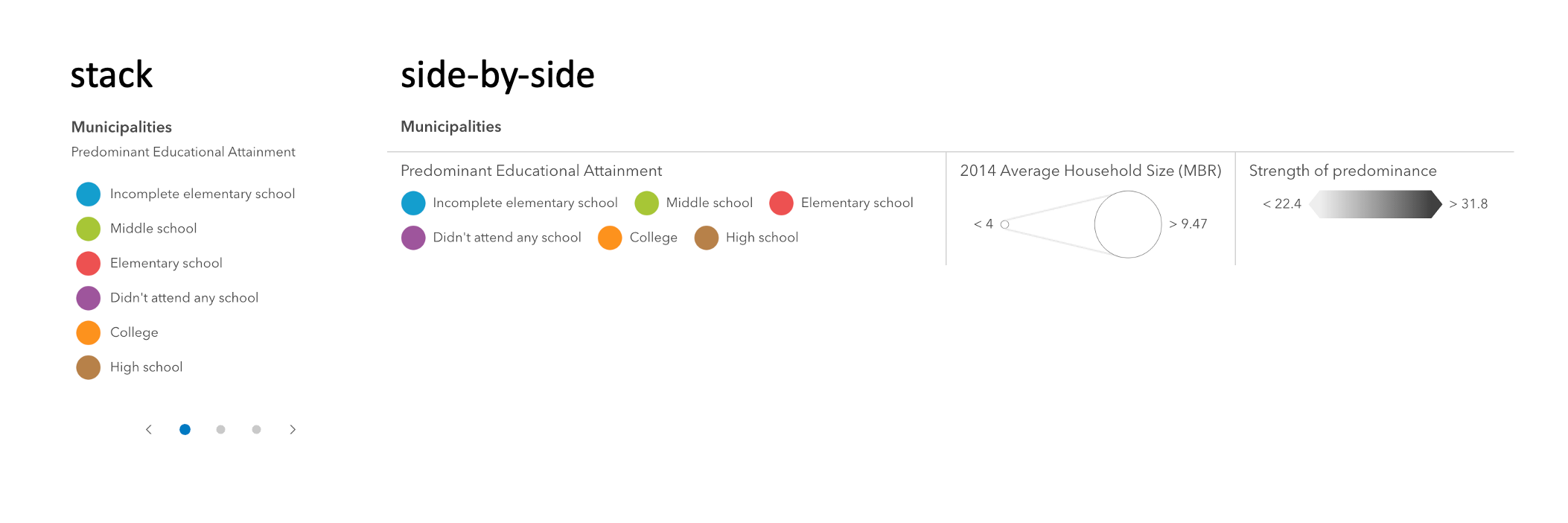
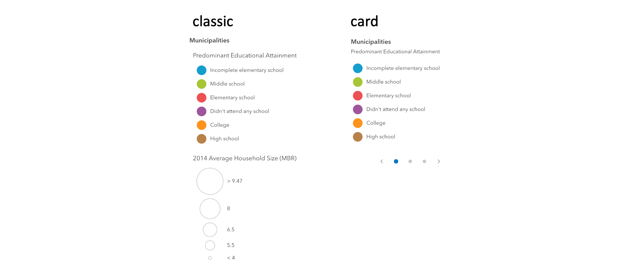
* <arcgis-legend legend-style="card" card-style-layout="stack"></arcgis-legend>
|
|
286
|
+
* ```
|
|
287
|
+
*
|
|
288
|
+
* ```js
|
|
289
|
+
* const legend = document.querySelector("arcgis-legend");
|
|
290
|
+
* legend.legendStyle = "card";
|
|
291
|
+
* legend.cardStyleLayout = "stack";
|
|
292
|
+
* ```
|
|
293
|
+
*/
|
|
136
294
|
cardStyleLayout?: "auto" | "side-by-side" | "stack";
|
|
137
295
|
/**
|
|
138
296
|
* Indicates the style of the legend. The style determines the legend's layout and behavior.
|
|
139
297
|
* You can either specify a string or an object to indicate the style. The known string values are the same values listed in
|
|
140
298
|
* the table within the `type` property.
|
|
141
299
|
*
|
|
142
|
-
*
|
|
143
|
-
*
|
|
144
|
-
*
|
|
145
|
-
* legend.legendStyle = "card";
|
|
300
|
+
* [](../sample-code/legend-card/)
|
|
301
|
+
*
|
|
302
|
+
* @see [cardStyleLayout](https://developers.arcgis.com/javascript/latest/references/map-components/arcgis-legend/#cardStyleLayout)
|
|
146
303
|
* @example
|
|
147
|
-
*
|
|
148
|
-
*
|
|
149
|
-
*
|
|
304
|
+
* Renders the legend in the card style with a stack layout
|
|
305
|
+
*
|
|
306
|
+
* ```js
|
|
307
|
+
* document.querySelector("arcgis-legend").legendStyle = legendStyle = {
|
|
150
308
|
* type: "card",
|
|
151
|
-
* layout: "
|
|
309
|
+
* layout: "stack"
|
|
152
310
|
* };
|
|
153
|
-
*
|
|
154
|
-
* // renders the legend in the classic layout
|
|
155
|
-
* legend.legendStyle = "classic";
|
|
311
|
+
* ```
|
|
156
312
|
* @default "classic"
|
|
157
313
|
*/
|
|
158
314
|
legendStyle: "card" | "classic" | {
|
|
@@ -5,20 +5,20 @@ import c from "@arcgis/core/widgets/Legend/LegendViewModel.js";
|
|
|
5
5
|
import { LitElement as g, createEvent as h, safeClassMap as p } from "@arcgis/lumina";
|
|
6
6
|
import { usePropertyChange as f } from "@arcgis/lumina/controllers";
|
|
7
7
|
import { classes as m } from "@arcgis/toolkit/dom";
|
|
8
|
-
import { u
|
|
9
|
-
import { u } from "../../chunks/useT9n.js";
|
|
8
|
+
import { u } from "../../chunks/useHandles.js";
|
|
9
|
+
import { u as _ } from "../../chunks/useT9n.js";
|
|
10
10
|
import { m as w } from "../../chunks/useViewModel.js";
|
|
11
11
|
import { g as s } from "../../chunks/globalCss.js";
|
|
12
12
|
/*! All material copyright Esri, All Rights Reserved, unless otherwise specified.
|
|
13
13
|
See https://js.arcgis.com/4.34/esri/copyright.txt for details.
|
|
14
|
-
v4.34.0-next.
|
|
15
|
-
const v = d`:host{--arcgis-internal-color-black-30: color-mix(in srgb, #000000 30.2%, transparent);--arcgis-internal-box-shadow: var(--calcite-spacing-none) var(--calcite-spacing-px) var(--calcite-spacing-base) var(--arcgis-internal-color-black-30);--arcgis-internal-panel-width: 300px;--arcgis-internal-panel-height: 100%;--arcgis-internal-panel-height-sm: 240px;--arcgis-internal-panel-height-md: 420px;--arcgis-internal-panel-height-lg: 540px;--arcgis-internal-panel-height-xl: 680px;--arcgis-internal-basemap-gallery-width-lg: 450px;--arcgis-expand-max-height: var(--calcite-spacing-xxxl);--arcgis-collapse-icon-flip: scaleX(1);--arcgis-row-direction: row;--arcgis-legend-internal-width: 300px}.esri-widget__heading{color:var(--calcite-color-text-2);margin:0 0 .5rem;font-weight:var(--calcite-font-weight-semibold)}h1.esri-widget__heading{font-size:var(--calcite-font-size-xl)}h2.esri-widget__heading{font-size:var(--calcite-font-size-md)}h3.esri-widget__heading,h4.esri-widget__heading,h5.esri-widget__heading,h6.esri-widget__heading{font-size:var(--calcite-font-size)}.esri-widget{--esri-widget-padding-x: 15px;--esri-widget-padding-y: var(--calcite-spacing-md);--esri-widget-padding: var(--esri-widget-padding-y) var(--esri-widget-padding-x);box-sizing:border-box;color:var(--calcite-color-text-2);background-color:var(--calcite-color-foreground-1);font-size:var(--calcite-font-size);line-height:1.3em}.esri-widget *,.esri-widget :before,.esri-widget :after{box-sizing:inherit}.esri-widget.esri-widget--disabled>*{opacity:.4;pointer-events:none}.esri-widget.esri-widget--compact{--esri-widget-padding-y: 0;--esri-widget-padding-x: 0}.esri-widget__anchor{color:var(--calcite-color-text-2)}.esri-widget__anchor:hover{color:var(--calcite-color-text-3)}.esri-widget__anchor:hover,.esri-widget__anchor:focus{text-decoration:underline}.esri-widget__anchor--disabled{opacity:.4;pointer-events:none}.esri-widget__header{background-color:var(--calcite-color-foreground-1);flex:1 0 100%;justify-content:space-between;align-items:center;width:100%;min-height:48px;padding:12px 0 12px 15px;display:flex}.esri-widget__header .esri-widget__heading{width:calc(100% - 48px);text-align:initial;color:var(--calcite-color-text-1);align-items:center;margin:0;padding:0;display:flex}.esri-widget__header-button{appearance:none;cursor:pointer;color:var(--calcite-color-text-2);background-color:var(--calcite-color-foreground-1);border:none;flex:0 0 48px;justify-content:center;align-self:stretch;align-items:center;width:48px;padding:0;display:flex}.esri-widget__footer{background-color:var(--calcite-color-foreground-1);justify-content:center;align-items:center;width:100%;min-height:48px;display:flex}.esri-widget__footer-pagination{color:var(--calcite-color-text-2);justify-content:space-between;align-items:center;display:flex}.esri-widget__footer-pagination-previous-button,.esri-widget__footer-pagination-next-button{cursor:pointer;background-color:var(--calcite-color-foreground-1);border:0;margin:0 7px;padding:12px 15px;transition:background-color .125s ease-in-out}.esri-widget__footer-pagination-previous-button:hover,.esri-widget__footer-pagination-previous-button:focus,.esri-widget__footer-pagination-next-button:hover,.esri-widget__footer-pagination-next-button:focus{color:var(--calcite-color-text-1);background-color:var(--calcite-color-foreground-1)}.esri-menu{visibility:hidden;z-index:1;background-clip:padding;background-color:var(--calcite-color-foreground-1);background-clip:padding-box;width:100%;max-height:0;margin:2px 0 0;padding:0;font-size:var(--calcite-font-size);line-height:var(--calcite-spacing-xl);position:absolute;top:100%;left:0;overflow:hidden;box-shadow:0 1px 2px #0000004d}.esri-menu .esri-menu__header{color:var(--calcite-color-text-inverse);background-color:var(--calcite-color-inverse);padding:6px 12px}.esri-menu__list{margin:0;padding:0;list-style:none}.esri-menu__list-item{cursor:pointer;border-top:1px solid #adadad4d;border-left:3px solid #0000;padding:.8em 1em}.esri-menu__list-item [class^=esri-icon-],.esri-menu__list-item [class*=" esri-icon-"]{padding-right:2.8px}.esri-menu__list-item:first-child{border-top:none}.esri-menu__list-item--focus,.esri-menu__list-item:hover,.esri-menu__list-item:focus{background-color:#303030}.esri-menu__list-item:active{background-color:#000}.esri-menu__list-item--active,.esri-menu__list-item--active:hover,.esri-menu__list-item--active:focus{background-color:var(--calcite-color-foreground-1);border-left-color:#2493f2}.esri-widget__table{border-collapse:collapse;color:var(--calcite-color-text-1);border:none;width:100%;line-height:1.3em}.esri-widget__table tr:nth-child(odd){background-color:var(--calcite-color-transparent)}.esri-widget__table tr:nth-child(2n){background-color:var(--calcite-color-transparent-press)}.esri-widget__table tr a{color:var(--calcite-color-text-2)}.esri-widget__table tr a:hover,.esri-widget__table tr a:focus{color:var(--calcite-color-text-1)}.esri-widget__table tr td,.esri-widget__table tr th{vertical-align:top;word-break:break-word;padding:.5em .7em;font-size:var(--calcite-font-size-sm);font-weight:var(--calcite-font-weight-regular)}.esri-widget__table tr th{text-align:left;border-right:3px solid #0000000d;width:50%}.esri-widget__table tr td{width:50%}.esri-input{color:var(--calcite-color-text-1);background-color:var(--calcite-color-foreground-1);border:1px solid #959595;font-size:var(--calcite-font-size)}.esri-input::-ms-clear{display:none}.esri-input::placeholder{opacity:1;color:var(--calcite-color-text-2)}.esri-input:placeholder-shown{text-overflow:ellipsis}.esri-input[type=text],.esri-input[type=password],.esri-input[type=number]{height:32px;padding:0 .5em}calcite-combobox.esri-input{border:none}.esri-widget__content--empty{text-align:center;color:var(--calcite-color-border-input);flex-flow:column wrap;align-items:center;padding:18px 22px;display:flex}.esri-widget__content--empty h1.esri-widget__heading,.esri-widget__content--empty h2.esri-widget__heading,.esri-widget__content--empty h3.esri-widget__heading,.esri-widget__content--empty h4.esri-widget__heading,.esri-widget__content--empty h5.esri-widget__heading{font-weight:var(--calcite-font-weight-regular)}.esri-widget__content-illustration--empty{width:128px;padding:1rem 0}.esri-widget__content-icon--empty{width:32px;padding:.5rem 0}.esri-select{appearance:none;cursor:pointer;color:var(--calcite-color-text-2);background:var(--calcite-color-foreground-1) url("data:image/svg+xml,%3Csvg xmlns='http://www.w3.org/2000/svg' viewBox='-8 -8 32 32' width='32' height='32'%3E%3Cpath d='M8 11.207l-4-4V5.793l4 4 4-4v1.414z' fill='%23adadad' fillrule='nonzero'/%3E%3C/svg%3E") 100% no-repeat;border:1px solid #959595;border-radius:0;width:100%;height:32px;margin:0;padding:0 .5em;font-family:inherit;font-size:.85em;display:block}.esri-select[disabled]{cursor:auto}.esri-select::-ms-expand{display:none}.esri-disabled a,.esri-disabled [role=menu],.esri-disabled [role=checkbox],.esri-disabled [class^=esri-icon-],.esri-disabled [class*=" esri-icon-"]{color:var(--calcite-color-text-3)}.keynav-mode .esri-widget:focus,.keynav-mode .esri-widget :focus{z-index:1;outline-offset:2px;outline:2px solid #adadad}.esri-widget__loader-animation{border:.15em solid #adadad4d;border-top-color:var(--calcite-color-border-input);border-radius:100%;width:1em;height:1em;font-size:var(--calcite-font-size-md);animation:1.25s linear infinite esri-rotate;display:block;transform:translateZ(0)}:dir(rtl) .esri-widget__table th{text-align:right;border-left:3px solid #0000000d;border-right:none}:dir(rtl) .esri-select{background-position:0}:dir(rtl) .esri-menu__list-item{border-left:none;border-right:3px solid #0000}:dir(rtl) .esri-menu__list-item [class^=esri-icon-],:dir(rtl) .esri-menu__list-item [class*=" esri-icon-"]{padding-left:2px;padding-right:0}:dir(rtl) .esri-menu__list-item--active{border-right-color:var(--calcite-color-brand)}.esri-icon-font-fallback-text{clip:rect(0 0 0 0);width:1px;height:1px;position:absolute;overflow:hidden}.esri-rotating{animation:1.25s linear infinite esri-rotate;transform:translateZ(0)}.esri-clearfix:before,.esri-clearfix:after{content:" ";display:table}.esri-clearfix:after{clear:both}.esri-interactive{cursor:pointer}.esri-hidden{display:none!important}.esri-invisible{visibility:hidden!important}.esri-offscreen{position:absolute;top:-999em;left:-999em}.esri-match-height{flex-direction:column;flex:auto;display:flex;overflow:hidden}:host{display:block;overflow:auto;width:var(--arcgis-legend-internal-width)}:host([card-style-layout="side-by-side"]){--arcgis-legend-internal-width: auto}`,
|
|
16
|
-
class
|
|
14
|
+
v4.34.0-next.128 */
|
|
15
|
+
const v = d`:host{--arcgis-internal-color-black-30: color-mix(in srgb, #000000 30.2%, transparent);--arcgis-internal-box-shadow: var(--calcite-spacing-none) var(--calcite-spacing-px) var(--calcite-spacing-base) var(--arcgis-internal-color-black-30);--arcgis-internal-panel-width: 300px;--arcgis-internal-panel-height: 100%;--arcgis-internal-panel-height-sm: 240px;--arcgis-internal-panel-height-md: 420px;--arcgis-internal-panel-height-lg: 540px;--arcgis-internal-panel-height-xl: 680px;--arcgis-internal-basemap-gallery-width-lg: 450px;--arcgis-expand-max-height: var(--calcite-spacing-xxxl);--arcgis-collapse-icon-flip: scaleX(1);--arcgis-row-direction: row;--arcgis-legend-internal-width: 300px;--arcgis-layout-padding-top: 0px;--arcgis-layout-padding-bottom: 0px;--arcgis-layout-padding-left: 0px;--arcgis-layout-padding-right: 0px}.esri-widget__heading{color:var(--calcite-color-text-2);margin:0 0 .5rem;font-weight:var(--calcite-font-weight-semibold)}h1.esri-widget__heading{font-size:var(--calcite-font-size-xl)}h2.esri-widget__heading{font-size:var(--calcite-font-size-md)}h3.esri-widget__heading,h4.esri-widget__heading,h5.esri-widget__heading,h6.esri-widget__heading{font-size:var(--calcite-font-size)}.esri-widget{--esri-widget-padding-x: 15px;--esri-widget-padding-y: var(--calcite-spacing-md);--esri-widget-padding: var(--esri-widget-padding-y) var(--esri-widget-padding-x);box-sizing:border-box;color:var(--calcite-color-text-2);background-color:var(--calcite-color-foreground-1);font-size:var(--calcite-font-size);line-height:1.3em}.esri-widget *,.esri-widget :before,.esri-widget :after{box-sizing:inherit}.esri-widget.esri-widget--disabled>*{opacity:.4;pointer-events:none}.esri-widget.esri-widget--compact{--esri-widget-padding-y: 0;--esri-widget-padding-x: 0}.esri-widget__anchor{color:var(--calcite-color-text-2)}.esri-widget__anchor:hover{color:var(--calcite-color-text-3)}.esri-widget__anchor:hover,.esri-widget__anchor:focus{text-decoration:underline}.esri-widget__anchor--disabled{opacity:.4;pointer-events:none}.esri-widget__header{background-color:var(--calcite-color-foreground-1);flex:1 0 100%;justify-content:space-between;align-items:center;width:100%;min-height:48px;padding:12px 0 12px 15px;display:flex}.esri-widget__header .esri-widget__heading{width:calc(100% - 48px);text-align:initial;color:var(--calcite-color-text-1);align-items:center;margin:0;padding:0;display:flex}.esri-widget__header-button{appearance:none;cursor:pointer;color:var(--calcite-color-text-2);background-color:var(--calcite-color-foreground-1);border:none;flex:0 0 48px;justify-content:center;align-self:stretch;align-items:center;width:48px;padding:0;display:flex}.esri-widget__footer{background-color:var(--calcite-color-foreground-1);justify-content:center;align-items:center;width:100%;min-height:48px;display:flex}.esri-widget__footer-pagination{color:var(--calcite-color-text-2);justify-content:space-between;align-items:center;display:flex}.esri-widget__footer-pagination-previous-button,.esri-widget__footer-pagination-next-button{cursor:pointer;background-color:var(--calcite-color-foreground-1);border:0;margin:0 7px;padding:12px 15px;transition:background-color .125s ease-in-out}.esri-widget__footer-pagination-previous-button:hover,.esri-widget__footer-pagination-previous-button:focus,.esri-widget__footer-pagination-next-button:hover,.esri-widget__footer-pagination-next-button:focus{color:var(--calcite-color-text-1);background-color:var(--calcite-color-foreground-1)}.esri-menu{visibility:hidden;z-index:1;background-clip:padding;background-color:var(--calcite-color-foreground-1);background-clip:padding-box;width:100%;max-height:0;margin:2px 0 0;padding:0;font-size:var(--calcite-font-size);line-height:var(--calcite-spacing-xl);position:absolute;top:100%;left:0;overflow:hidden;box-shadow:0 1px 2px #0000004d}.esri-menu .esri-menu__header{color:var(--calcite-color-text-inverse);background-color:var(--calcite-color-inverse);padding:6px 12px}.esri-menu__list{margin:0;padding:0;list-style:none}.esri-menu__list-item{cursor:pointer;border-top:1px solid #adadad4d;border-left:3px solid #0000;padding:.8em 1em}.esri-menu__list-item [class^=esri-icon-],.esri-menu__list-item [class*=" esri-icon-"]{padding-right:2.8px}.esri-menu__list-item:first-child{border-top:none}.esri-menu__list-item--focus,.esri-menu__list-item:hover,.esri-menu__list-item:focus{background-color:#303030}.esri-menu__list-item:active{background-color:#000}.esri-menu__list-item--active,.esri-menu__list-item--active:hover,.esri-menu__list-item--active:focus{background-color:var(--calcite-color-foreground-1);border-left-color:#2493f2}.esri-widget__table{border-collapse:collapse;color:var(--calcite-color-text-1);border:none;width:100%;line-height:1.3em}.esri-widget__table tr:nth-child(odd){background-color:var(--calcite-color-transparent)}.esri-widget__table tr:nth-child(2n){background-color:var(--calcite-color-transparent-press)}.esri-widget__table tr a{color:var(--calcite-color-text-2)}.esri-widget__table tr a:hover,.esri-widget__table tr a:focus{color:var(--calcite-color-text-1)}.esri-widget__table tr td,.esri-widget__table tr th{vertical-align:top;word-break:break-word;padding:.5em .7em;font-size:var(--calcite-font-size-sm);font-weight:var(--calcite-font-weight-regular)}.esri-widget__table tr th{text-align:left;border-right:3px solid #0000000d;width:50%}.esri-widget__table tr td{width:50%}.esri-input{color:var(--calcite-color-text-1);background-color:var(--calcite-color-foreground-1);border:1px solid #959595;font-size:var(--calcite-font-size)}.esri-input::-ms-clear{display:none}.esri-input::placeholder{opacity:1;color:var(--calcite-color-text-2)}.esri-input:placeholder-shown{text-overflow:ellipsis}.esri-input[type=text],.esri-input[type=password],.esri-input[type=number]{height:32px;padding:0 .5em}calcite-combobox.esri-input{border:none}.esri-widget__content--empty{text-align:center;color:var(--calcite-color-border-input);flex-flow:column wrap;align-items:center;padding:18px 22px;display:flex}.esri-widget__content--empty h1.esri-widget__heading,.esri-widget__content--empty h2.esri-widget__heading,.esri-widget__content--empty h3.esri-widget__heading,.esri-widget__content--empty h4.esri-widget__heading,.esri-widget__content--empty h5.esri-widget__heading{font-weight:var(--calcite-font-weight-regular)}.esri-widget__content-illustration--empty{width:128px;padding:1rem 0}.esri-widget__content-icon--empty{width:32px;padding:.5rem 0}.esri-select{appearance:none;cursor:pointer;color:var(--calcite-color-text-2);background:var(--calcite-color-foreground-1) url("data:image/svg+xml,%3Csvg xmlns='http://www.w3.org/2000/svg' viewBox='-8 -8 32 32' width='32' height='32'%3E%3Cpath d='M8 11.207l-4-4V5.793l4 4 4-4v1.414z' fill='%23adadad' fillrule='nonzero'/%3E%3C/svg%3E") 100% no-repeat;border:1px solid #959595;border-radius:0;width:100%;height:32px;margin:0;padding:0 .5em;font-family:inherit;font-size:.85em;display:block}.esri-select[disabled]{cursor:auto}.esri-select::-ms-expand{display:none}.esri-disabled a,.esri-disabled [role=menu],.esri-disabled [role=checkbox],.esri-disabled [class^=esri-icon-],.esri-disabled [class*=" esri-icon-"]{color:var(--calcite-color-text-3)}.keynav-mode .esri-widget:focus,.keynav-mode .esri-widget :focus{z-index:1;outline-offset:2px;outline:2px solid #adadad}.esri-widget__loader-animation{border:.15em solid #adadad4d;border-top-color:var(--calcite-color-border-input);border-radius:100%;width:1em;height:1em;font-size:var(--calcite-font-size-md);animation:1.25s linear infinite esri-rotate;display:block;transform:translateZ(0)}:dir(rtl) .esri-widget__table th{text-align:right;border-left:3px solid #0000000d;border-right:none}:dir(rtl) .esri-select{background-position:0}:dir(rtl) .esri-menu__list-item{border-left:none;border-right:3px solid #0000}:dir(rtl) .esri-menu__list-item [class^=esri-icon-],:dir(rtl) .esri-menu__list-item [class*=" esri-icon-"]{padding-left:2px;padding-right:0}:dir(rtl) .esri-menu__list-item--active{border-right-color:var(--calcite-color-brand)}.esri-icon-font-fallback-text{clip:rect(0 0 0 0);width:1px;height:1px;position:absolute;overflow:hidden}.esri-rotating{animation:1.25s linear infinite esri-rotate;transform:translateZ(0)}.esri-clearfix:before,.esri-clearfix:after{content:" ";display:table}.esri-clearfix:after{clear:both}.esri-interactive{cursor:pointer}.esri-hidden{display:none!important}.esri-invisible{visibility:hidden!important}.esri-offscreen{position:absolute;top:-999em;left:-999em}.esri-match-height{flex-direction:column;flex:auto;display:flex;overflow:hidden}:host{display:block;overflow:auto;width:var(--arcgis-legend-internal-width)}:host([card-style-layout="side-by-side"]){--arcgis-legend-internal-width: auto}`, y = w(c);
|
|
16
|
+
class b extends g {
|
|
17
17
|
constructor() {
|
|
18
|
-
super(...arguments), this.messages =
|
|
18
|
+
super(...arguments), this.messages = _({}), this.final = u("destroy"), this.viewModel = y(this), this._isCardStyle = !1, this.view = this.viewModel.view, this.icon = "icon", this.activeLayerInfos = this.viewModel.activeLayerInfos, this.basemapLegendVisible = this.viewModel.basemapLegendVisible, this.headingLevel = 3, this.hideLayersNotInCurrentView = this.viewModel.hideLayersNotInCurrentView, this.respectLayerDefinitionExpression = this.viewModel.respectLayerDefinitionExpression, this.ignoreLayerVisibility = !this.viewModel.respectLayerVisibility, this.respectLayerVisibilityDisabled = !this.viewModel.respectLayerVisibility, this.layerInfos = this.viewModel.layerInfos, this.loading = this.viewModel.loading, this.legendStyle = "classic", this.autoDestroyDisabled = !1, this.state = this.viewModel.state, this.arcgisPropertyChange = f()("state"), this.arcgisReady = h();
|
|
19
19
|
}
|
|
20
20
|
static {
|
|
21
|
-
this.properties = { _isCardStyle: 16, referenceElement: 1, position: 1, icon: 1, activeLayerInfos: 0, basemapLegendVisible: 5, headingLevel: 9, hideLayersNotInCurrentView: 5, respectLayerDefinitionExpression: 5, ignoreLayerVisibility: 5, layerInfos: 0, cardStyleLayout:
|
|
21
|
+
this.properties = { _isCardStyle: 16, view: 0, referenceElement: 1, position: 1, icon: 1, activeLayerInfos: 0, basemapLegendVisible: 5, headingLevel: 9, hideLayersNotInCurrentView: 5, respectLayerDefinitionExpression: 5, ignoreLayerVisibility: 5, respectLayerVisibilityDisabled: 5, layerInfos: 0, loading: 39, cardStyleLayout: 1, legendStyle: 1, autoDestroyDisabled: 5, messageOverrides: 0, label: 1, state: 3 };
|
|
22
22
|
}
|
|
23
23
|
static {
|
|
24
24
|
this.styles = v;
|
|
@@ -47,7 +47,7 @@ class y extends g {
|
|
|
47
47
|
}), this.requestUpdate();
|
|
48
48
|
}
|
|
49
49
|
render() {
|
|
50
|
-
return r`<div class=${p(m(s.widget, { [s.panel]: !this._isCardStyle }))}>${this._isCardStyle ? r`<arcgis-legend-card-view .activeLayerInfos=${this.activeLayerInfos} .headingLevel=${this.headingLevel} .messages=${this.messages} .layout=${this.cardStyleLayout} .view=${this.
|
|
50
|
+
return r`<div class=${p(m(s.widget, { [s.panel]: !this._isCardStyle }))}>${this._isCardStyle && this.view ? r`<arcgis-legend-card-view .activeLayerInfos=${this.activeLayerInfos} .headingLevel=${this.headingLevel} .messages=${this.messages} .layout=${this.cardStyleLayout} .view=${this.view}></arcgis-legend-card-view>` : r`<arcgis-legend-classic-view .activeLayerInfos=${this.activeLayerInfos} .headingLevel=${this.headingLevel} .messages=${this.messages}></arcgis-legend-classic-view>`}</div>`;
|
|
51
51
|
}
|
|
52
52
|
_renderOnActiveLayerInfoChange(e) {
|
|
53
53
|
const i = a(() => e.version, () => this.requestUpdate());
|
|
@@ -56,7 +56,7 @@ class y extends g {
|
|
|
56
56
|
this.final.addHandles(n, `version_${e.layer.uid}`), e.children.forEach((t) => this._renderOnActiveLayerInfoChange(t));
|
|
57
57
|
}
|
|
58
58
|
}
|
|
59
|
-
l("arcgis-legend",
|
|
59
|
+
l("arcgis-legend", b);
|
|
60
60
|
export {
|
|
61
|
-
|
|
61
|
+
b as ArcgisLegend
|
|
62
62
|
};
|
|
@@ -3,7 +3,7 @@
|
|
|
3
3
|
import { JsxNode, PublicLitElement as LitElement, TargetedEvent } from '@arcgis/lumina';
|
|
4
4
|
import { ArcgisLegend } from '../arcgis-legend/customElement.js';
|
|
5
5
|
|
|
6
|
-
/**
|
|
6
|
+
/** @private */
|
|
7
7
|
export declare class ArcgisLegendCardColorRamp extends LitElement {
|
|
8
8
|
cssEffectFilter?: string;
|
|
9
9
|
legendElement: __esri.ColorRampElement | __esri.HeatmapRampElement | __esri.OpacityRampElement | __esri.StretchRampElement;
|
|
@@ -6,7 +6,7 @@ import { c as b } from "../../chunks/svgUtils.js";
|
|
|
6
6
|
import { g as L } from "../../chunks/utils2.js";
|
|
7
7
|
/*! All material copyright Esri, All Rights Reserved, unless otherwise specified.
|
|
8
8
|
See https://js.arcgis.com/4.34/esri/copyright.txt for details.
|
|
9
|
-
v4.34.0-next.
|
|
9
|
+
v4.34.0-next.128 */
|
|
10
10
|
const R = f`:host{display:flex}.arcgis-legend--card__layer-row{display:flex;flex:1}.arcgis-legend--card__color-ramp-container{justify-content:center}.arcgis-legend--card__symbol-container{display:flex;flex-direction:column}.arcgis-legend--card__interval-separators-container{text-align:center}.arcgis-legend--card__interval-separator{font-size:.5em}.arcgis-legend--card__ramp-label{margin:0 .5em;white-space:nowrap;height:25px;line-height:25px}`, a = {
|
|
11
11
|
layerRow: "arcgis-legend--card__layer-row",
|
|
12
12
|
colorRampContainer: "arcgis-legend--card__color-ramp-container",
|
|
@@ -4,7 +4,7 @@ import { JsxNode, PublicLitElement as LitElement, TargetedEvent } from '@arcgis/
|
|
|
4
4
|
import { HeadingLevel } from '../../support/heading';
|
|
5
5
|
import { ArcgisLegend } from '../arcgis-legend/customElement.js';
|
|
6
6
|
|
|
7
|
-
/**
|
|
7
|
+
/** @private */
|
|
8
8
|
export declare class ArcgisLegendCardElement extends LitElement {
|
|
9
9
|
cssEffectFilter?: string;
|
|
10
10
|
/** @default false */
|
|
@@ -9,7 +9,7 @@ import { a as k, g as f } from "../../chunks/titleUtils.js";
|
|
|
9
9
|
import { i as C } from "../../chunks/utils2.js";
|
|
10
10
|
/*! All material copyright Esri, All Rights Reserved, unless otherwise specified.
|
|
11
11
|
See https://js.arcgis.com/4.34/esri/copyright.txt for details.
|
|
12
|
-
v4.34.0-next.
|
|
12
|
+
v4.34.0-next.128 */
|
|
13
13
|
const L = x`.esri-widget__heading{color:var(--calcite-color-text-2);margin:0 0 .5rem;font-weight:var(--calcite-font-weight-semibold)}h1.esri-widget__heading{font-size:var(--calcite-font-size-xl)}h2.esri-widget__heading{font-size:var(--calcite-font-size-md)}h3.esri-widget__heading,h4.esri-widget__heading,h5.esri-widget__heading,h6.esri-widget__heading{font-size:var(--calcite-font-size)}.arcgis-legend--card__section{word-break:break-word;word-wrap:break-word;padding:var(--calcite-spacing-sm) var(--calcite-spacing-md);min-width:250px;max-width:500px;height:100%;height:-moz-available;height:-webkit-fill-available;height:fill-available;overflow:auto;font-size:var(--calcite-font-size-sm)}.arcgis-legend--card__carousel-title-container{margin-bottom:var(--calcite-spacing-sm)}.arcgis-legend--card__carousel-title{margin:0}.arcgis-legend--card__section-title{font-weight:var(--calcite-font-weight-normal)}.arcgis-legend--card__layer-caption{padding:var(--calcite-spacing-xs) 0;margin:0;font-weight:var(--calcite-font-weight-normal)}.arcgis-legend--card__imagery-layer-image--stretched{display:block;margin-bottom:-2px}.arcgis-legend--card__image-label{padding-right:var(--calcite-spacing-xs);padding-left:var(--calcite-spacing-xs)}.arcgis-legend--card__label-element{margin:.1em;padding:.5em 1em;min-width:2em;min-height:1em;text-align:center;display:flex;align-items:center;justify-content:center;flex:1}.arcgis-legend--card__layer-row{display:flex;align-items:center}.arcgis-legend--card__symbol{display:block;margin:auto}.arcgis-legend--card__pie-chart-ramp-preview{display:flex;justify-content:center}.arcgis-legend--card__relationship-container{display:flex;flex-direction:column}.arcgis-legend--card__relationship-container .arcgis-legend--card__layer-row{padding-bottom:.5em}.arcgis-legend--card__relationship-container .arcgis-legend--card__layer-row:last-child{padding-bottom:0}.arcgis-legend--card__container{display:flex;gap:var(--calcite-spacing-sm);flex-wrap:wrap}.arcgis-legend--card__background-styles-container{display:flex;flex-wrap:wrap}:host([stacked]) .arcgis-legend--card__container{display:table}:host([stacked]) .arcgis-legend--card__symbol-row{display:table-row;width:100%}:host([stacked]) .arcgis-legend--card__label-cell{display:table-cell;vertical-align:middle;padding:var(--calcite-spacing-xxs)}:host([stacked]) .arcgis-legend--card__symbol-cell{display:table-cell;vertical-align:middle;text-align:center;padding:var(--calcite-spacing-xxs)}:host([stacked]) .arcgis-legend--card__symbol-cell div{display:flex;align-items:center;justify-content:center}`, a = {
|
|
14
14
|
carouselTitleContainer: "arcgis-legend--card__carousel-title-container",
|
|
15
15
|
carouselTitle: "arcgis-legend--card__carousel-title",
|
|
@@ -3,7 +3,7 @@
|
|
|
3
3
|
import { JsxNode, PublicLitElement as LitElement, TargetedEvent } from '@arcgis/lumina';
|
|
4
4
|
import { ArcgisLegend } from '../arcgis-legend/customElement.js';
|
|
5
5
|
|
|
6
|
-
/**
|
|
6
|
+
/** @private */
|
|
7
7
|
export declare class LegendCardSizeRamp extends LitElement {
|
|
8
8
|
/** @default false */
|
|
9
9
|
hasIndicators: boolean;
|
|
@@ -4,7 +4,7 @@ import { LitElement as I, safeStyleMap as z, safeClassMap as g } from "@arcgis/l
|
|
|
4
4
|
import { p as Y } from "../../chunks/utils2.js";
|
|
5
5
|
/*! All material copyright Esri, All Rights Reserved, unless otherwise specified.
|
|
6
6
|
See https://js.arcgis.com/4.34/esri/copyright.txt for details.
|
|
7
|
-
v4.34.0-next.
|
|
7
|
+
v4.34.0-next.128 */
|
|
8
8
|
const P = C`.arcgis-legend--card__size-ramp--container{display:flex;align-items:center;justify-content:center}.arcgis-legend--card__size-ramp--vertical-container{display:flex;flex-direction:column;align-items:center;justify-content:center}.arcgis-legend--card__size-ramp--label{margin:0 .5em;white-space:nowrap}.arcgis-legend--card__size-ramp--vertical-ramp{display:flex;flex-direction:column;align-items:center}.arcgis-legend--card__size-ramp--ramp{display:flex;flex-direction:row-reverse;align-items:center}.arcgis-legend--card__size-ramp--preview{display:flex}`, d = {
|
|
9
9
|
container: "arcgis-legend--card__size-ramp--container",
|
|
10
10
|
verticalContainer: "arcgis-legend--card__size-ramp--vertical-container",
|
package/dist/components/arcgis-legend-card-univariate-above-and-below-ramp/customElement.d.ts
CHANGED
|
@@ -3,7 +3,7 @@
|
|
|
3
3
|
import { JsxNode, PublicLitElement as LitElement, TargetedEvent } from '@arcgis/lumina';
|
|
4
4
|
import { ArcgisLegend } from '../arcgis-legend/customElement.js';
|
|
5
5
|
|
|
6
|
-
/**
|
|
6
|
+
/** @private */
|
|
7
7
|
export declare class LegendCardUnivariateAboveAndBelowRamp extends LitElement {
|
|
8
8
|
cssEffectFilter?: string;
|
|
9
9
|
legendElement: __esri.UnivariateColorSizeRampElement;
|
|
@@ -5,7 +5,7 @@ import { c as S } from "../../chunks/utils.js";
|
|
|
5
5
|
import { f as k, h as B, b, c as f, a as U } from "../../chunks/univariateUtils.js";
|
|
6
6
|
/*! All material copyright Esri, All Rights Reserved, unless otherwise specified.
|
|
7
7
|
See https://js.arcgis.com/4.34/esri/copyright.txt for details.
|
|
8
|
-
v4.34.0-next.
|
|
8
|
+
v4.34.0-next.128 */
|
|
9
9
|
const F = E`.arcgis-legend--card__layer-row{display:flex;align-items:center}.arcgis-legend--card__symbol{display:block;margin:auto}.arcgis-legend--card__symbol-container{position:relative}.arcgis-legend__ramp-labels{display:flex;flex-flow:column nowrap;justify-content:space-between}.arcgis-legend__layer-cell{padding:var(--calcite-spacing-xxs) 0;min-width:100px;vertical-align:middle;word-break:break-word}.arcgis-legend__layer-cell--info{padding-right:var(--calcite-spacing-sm);padding-left:var(--calcite-spacing-sm);max-width:250px;word-break:normal;word-wrap:normal;font-size:var(--calcite-font-size-sm)}.arcgis-univariate-above-and-below-ramp__color--card{position:relative}.arcgis-univariate-above-and-below-ramp__color--card:before{content:"";border-left:var(--calcite-border-width-sm) solid var(--calcite-color-background);border-right:var(--calcite-border-width-sm) solid var(--calcite-color-background);width:100%;height:15px;display:block;position:absolute;top:var(--calcite-border-width-sm)}.arcgis-univariate-above-and-below-ramp__symbol{display:flex;align-items:center;justify-content:center}`, i = {
|
|
10
10
|
layerRow: "arcgis-legend--card__layer-row",
|
|
11
11
|
symbol: "arcgis-legend--card__symbol",
|
|
@@ -3,7 +3,7 @@
|
|
|
3
3
|
import { JsxNode, PublicLitElement as LitElement, TargetedEvent } from '@arcgis/lumina';
|
|
4
4
|
import { ArcgisLegend } from '../arcgis-legend/customElement.js';
|
|
5
5
|
|
|
6
|
-
/**
|
|
6
|
+
/** @private */
|
|
7
7
|
export declare class LegendCardUnivariateColorSizeRamp extends LitElement {
|
|
8
8
|
cssEffectFilter?: string;
|
|
9
9
|
legendElement: __esri.UnivariateColorSizeRampElement;
|
|
@@ -5,7 +5,7 @@ import { c as x } from "../../chunks/utils.js";
|
|
|
5
5
|
import { g as $, h as C, b as z, c as E, a as S } from "../../chunks/univariateUtils.js";
|
|
6
6
|
/*! All material copyright Esri, All Rights Reserved, unless otherwise specified.
|
|
7
7
|
See https://js.arcgis.com/4.34/esri/copyright.txt for details.
|
|
8
|
-
v4.34.0-next.
|
|
8
|
+
v4.34.0-next.128 */
|
|
9
9
|
const L = u`.arcgis-legend--card__layer-row,.arcgis-legend--card__symbol{display:flex;align-items:center}.arcgis-legend--card__symbol-container{position:relative}.arcgis-legend__ramp-labels{display:flex;flex-flow:column nowrap;justify-content:space-between}.arcgis-legend__layer-cell{padding:var(--calcite-spacing-xxs) 0;min-width:100px;vertical-align:middle;word-break:break-word}.arcgis-legend__layer-cell--info{padding-right:var(--calcite-spacing-sm);padding-left:var(--calcite-spacing-sm);max-width:250px;word-break:normal;word-wrap:normal;font-size:var(--calcite-font-size-sm)}.arcgis-univariate-above-and-below-ramp__color--card{position:relative}.arcgis-univariate-above-and-below-ramp__color--card:before{content:"";border-left:var(--calcite-border-width-sm) solid var(--calcite-color-background);border-right:var(--calcite-border-width-sm) solid var(--calcite-color-background);width:100%;height:15px;display:block;position:absolute;top:var(--calcite-border-width-sm)}.arcgis-univariate-above-and-below-ramp__symbol{display:flex;align-items:center;justify-content:center}`, i = {
|
|
10
10
|
layerRow: "arcgis-legend--card__layer-row",
|
|
11
11
|
symbol: "arcgis-legend--card__symbol",
|
|
@@ -5,7 +5,7 @@ import { HeadingLevel } from '../../support/heading';
|
|
|
5
5
|
import { ArcgisLegend } from '../arcgis-legend/customElement.js';
|
|
6
6
|
|
|
7
7
|
export type CardLayout = "auto" | "side-by-side" | "stack";
|
|
8
|
-
/**
|
|
8
|
+
/** @private */
|
|
9
9
|
export declare class LegendCardView extends LitElement {
|
|
10
10
|
activeLayerInfos?: __esri.Collection<__esri.ActiveLayerInfo>;
|
|
11
11
|
/** @default 3 */
|
|
@@ -9,7 +9,7 @@ import { H as _ } from "../../chunks/heading.js";
|
|
|
9
9
|
import { g as v } from "../../chunks/globalCss.js";
|
|
10
10
|
/*! All material copyright Esri, All Rights Reserved, unless otherwise specified.
|
|
11
11
|
See https://js.arcgis.com/4.34/esri/copyright.txt for details.
|
|
12
|
-
v4.34.0-next.
|
|
12
|
+
v4.34.0-next.128 */
|
|
13
13
|
const u = d`.esri-widget__heading{color:var(--calcite-color-text-2);margin:0 0 .5rem;font-weight:var(--calcite-font-weight-semibold)}h1.esri-widget__heading{font-size:var(--calcite-font-size-xl)}h2.esri-widget__heading{font-size:var(--calcite-font-size-md)}h3.esri-widget__heading,h4.esri-widget__heading,h5.esri-widget__heading,h6.esri-widget__heading{font-size:var(--calcite-font-size)}:host{display:flex;flex-direction:row;position:relative;transition:max-width .25s ease-in-out;overflow-x:auto}calcite-carousel-item[selected]{flex:1;overflow:auto}.arcgis-legend--card__message{padding:.5em 1em}.arcgis-legend--card__service-caption-text{margin:0}.arcgis-legend--card__service-content{display:flex;flex:1}.arcgis-legend--card__service-content>arcgis-legend-card-element:not(:first-child){border-left:1px solid var(--calcite-color-border-2)}.arcgis-legend--card__service{border-left:var(--calcite-border-width-sm) solid var(--calcite-color-border-2);min-width:fit-content;display:flex;flex-direction:column;flex:1}.arcgis-legend--card__service-caption-container{border-bottom:1px solid var(--calcite-color-border-2);padding:var(--calcite-spacing-md)}`, n = {
|
|
14
14
|
message: "arcgis-legend--card__message",
|
|
15
15
|
serviceCaptionText: "arcgis-legend--card__service-caption-text",
|
|
@@ -3,7 +3,7 @@
|
|
|
3
3
|
import { JsxNode, PublicLitElement as LitElement, TargetedEvent } from '@arcgis/lumina';
|
|
4
4
|
import { ArcgisLegend } from '../arcgis-legend/customElement.js';
|
|
5
5
|
|
|
6
|
-
/**
|
|
6
|
+
/** @private */
|
|
7
7
|
export declare class ArcgisLegendClassicColorRamp extends LitElement {
|
|
8
8
|
legendElement: __esri.ColorRampElement | __esri.HeatmapRampElement | __esri.OpacityRampElement | __esri.StretchRampElement;
|
|
9
9
|
/** @default 1 */
|
|
@@ -4,7 +4,7 @@ import { LitElement as g, safeClassMap as i, safeStyleMap as p } from "@arcgis/l
|
|
|
4
4
|
import { g as o } from "../../chunks/utils2.js";
|
|
5
5
|
/*! All material copyright Esri, All Rights Reserved, unless otherwise specified.
|
|
6
6
|
See https://js.arcgis.com/4.34/esri/copyright.txt for details.
|
|
7
|
-
v4.34.0-next.
|
|
7
|
+
v4.34.0-next.128 */
|
|
8
8
|
const m = c`.arcgis-legend__layer-row{display:flex}.arcgis-legend__layer-cell{padding:var(--calcite-spacing-xxs) 0;min-width:100px;vertical-align:middle;word-break:break-word}.arcgis-legend__layer-cell--symbols{min-width:10px;text-align:center}.arcgis-legend__layer-cell--info{padding-right:var(--calcite-spacing-sm);padding-left:var(--calcite-spacing-sm);max-width:250px;word-break:normal;word-wrap:normal;font-size:var(--calcite-font-size-sm)}.arcgis-legend__ramps{margin-left:var(--calcite-spacing-sm)}:dir(rtl) .arcgis-legend__ramps{margin-right:var(--calcite-spacing-sm);margin-left:auto}.arcgis-legend__color-ramp{width:24px}.arcgis-legend__opacity-ramp{background-image:url(data:image/png;base64,iVBORw0KGgoAAAANSUhEUgAAAAgAAAAICAIAAABLbSncAAAAGXRFWHRTb2Z0d2FyZQBBZG9iZSBJbWFnZVJlYWR5ccllPAAAA2hpVFh0WE1MOmNvbS5hZG9iZS54bXAAAAAAADw/eHBhY2tldCBiZWdpbj0i77u/IiBpZD0iVzVNME1wQ2VoaUh6cmVTek5UY3prYzlkIj8+IDx4OnhtcG1ldGEgeG1sbnM6eD0iYWRvYmU6bnM6bWV0YS8iIHg6eG1wdGs9IkFkb2JlIFhNUCBDb3JlIDUuMC1jMDYxIDY0LjE0MDk0OSwgMjAxMC8xMi8wNy0xMDo1NzowMSAgICAgICAgIj4gPHJkZjpSREYgeG1sbnM6cmRmPSJodHRwOi8vd3d3LnczLm9yZy8xOTk5LzAyLzIyLXJkZi1zeW50YXgtbnMjIj4gPHJkZjpEZXNjcmlwdGlvbiByZGY6YWJvdXQ9IiIgeG1sbnM6eG1wTU09Imh0dHA6Ly9ucy5hZG9iZS5jb20veGFwLzEuMC9tbS8iIHhtbG5zOnN0UmVmPSJodHRwOi8vbnMuYWRvYmUuY29tL3hhcC8xLjAvc1R5cGUvUmVzb3VyY2VSZWYjIiB4bWxuczp4bXA9Imh0dHA6Ly9ucy5hZG9iZS5jb20veGFwLzEuMC8iIHhtcE1NOk9yaWdpbmFsRG9jdW1lbnRJRD0ieG1wLmRpZDowMTgwMTE3NDA3MjA2ODExODcxRkM3N0RBQzA4QkVDRSIgeG1wTU06RG9jdW1lbnRJRD0ieG1wLmRpZDpEOTY4RkNFNjM1MzYxMUU0ODlDMUFFQ0M2REU5QzFCNCIgeG1wTU06SW5zdGFuY2VJRD0ieG1wLmlpZDpEOTY4RkNFNTM1MzYxMUU0ODlDMUFFQ0M2REU5QzFCNCIgeG1wOkNyZWF0b3JUb29sPSJBZG9iZSBQaG90b3Nob3AgQ1M1LjEgTWFjaW50b3NoIj4gPHhtcE1NOkRlcml2ZWRGcm9tIHN0UmVmOmluc3RhbmNlSUQ9InhtcC5paWQ6MDE4MDExNzQwNzIwNjgxMTg3MUZDNzdEQUMwOEJFQ0UiIHN0UmVmOmRvY3VtZW50SUQ9InhtcC5kaWQ6MDE4MDExNzQwNzIwNjgxMTg3MUZDNzdEQUMwOEJFQ0UiLz4gPC9yZGY6RGVzY3JpcHRpb24+IDwvcmRmOlJERj4gPC94OnhtcG1ldGE+IDw/eHBhY2tldCBlbmQ9InIiPz6SLS5VAAAAKElEQVR42mI8c+YMAwwYGxvD2UwMOADpEoz///+Hc86ePUsLOwACDABC1ghwV8TLOQAAAABJRU5ErkJggg==)}.arcgis-legend__ramp-labels{display:flex;flex-flow:column nowrap;justify-content:space-between}.arcgis-legend__ramp-label{position:relative;padding:0 var(--calcite-spacing-sm);line-height:var(--calcite-font-size-sm);white-space:nowrap;font-size:var(--calcite-font-size-sm)}.arcgis-legend__ramp-label:before{display:block;position:absolute;top:.25em;right:100%;border-width:3px 4px 3px 0;border-style:solid;border-color:transparent rgba(0,1,0) transparent transparent;width:0;height:0;content:""}.arcgis-legend__ramp-label:first-child{margin-top:calc(var(--calcite-font-size-sm) / 3 * -1)}.arcgis-legend__ramp-label:last-child{bottom:calc(var(--calcite-font-size-sm) * .25 * -1)}.arcgis-legend-layer-caption{display:table-caption;padding:var(--calcite-spacing-sm) 0}:dir(rtl) .arcgis-legend__ramp-label:before{right:auto;left:100%;border-width:3px 0 3px 4px;border-color:transparent transparent transparent rgba(0,1,0)}`, a = {
|
|
9
9
|
layerRow: "arcgis-legend__layer-row",
|
|
10
10
|
layerInfo: "arcgis-legend__layer-cell arcgis-legend__layer-cell--info",
|