@arcgis/core 6.0.0-next.26 → 6.0.0-next.28
This diff represents the content of publicly available package versions that have been released to one of the supported registries. The information contained in this diff is provided for informational purposes only and reflects changes between package versions as they appear in their respective public registries.
- package/Map.d.ts +6 -0
- package/analysis/AreaMeasurementAnalysis.d.ts +4 -2
- package/analysis/DirectLineMeasurementAnalysis.d.ts +8 -4
- package/assets/esri/core/workers/RemoteClient.js +1 -1
- package/assets/esri/core/workers/chunks/0363d29fc665d169ebc4.js +1 -0
- package/assets/esri/core/workers/chunks/037c67ef5c4398d5954d.js +1 -0
- package/assets/esri/core/workers/chunks/03f33cb78b5405ab7e23.js +1 -0
- package/assets/esri/core/workers/chunks/07b726a46864501b90a0.js +1 -0
- package/assets/esri/core/workers/chunks/0864da8f8f147016cf1c.js +1 -0
- package/assets/esri/core/workers/chunks/{768389f7f8dba6080df7.js → 0cc7fba402a93e6d2455.js} +2 -2
- package/assets/esri/core/workers/chunks/0cfdeb53fb7d5532cf01.js +1 -0
- package/assets/esri/core/workers/chunks/112ed86f812e4400a7e0.js +1 -0
- package/assets/esri/core/workers/chunks/177f353ce72133e2eeed.js +1 -0
- package/assets/esri/core/workers/chunks/1dc6f093028530a492e6.js +1 -0
- package/assets/esri/core/workers/chunks/2294254af2c6afb560ee.js +1 -0
- package/assets/esri/core/workers/chunks/23a4806b4cdf7cc32e4d.js +1 -0
- package/assets/esri/core/workers/chunks/2447d2e2a4a3ab8fcf94.js +1 -0
- package/assets/esri/core/workers/chunks/271ae7deccb94112c2df.js +1 -0
- package/assets/esri/core/workers/chunks/2df37a9a95ceebb87a5f.js +1 -0
- package/assets/esri/core/workers/chunks/2e00c155e447e4930442.js +1 -0
- package/assets/esri/core/workers/chunks/2e9a1673b1d51aa082b6.js +1 -0
- package/assets/esri/core/workers/chunks/344f5334ad95c7974349.js +1 -0
- package/assets/esri/core/workers/chunks/348f1def9cd2ddf92e87.js +1 -0
- package/assets/esri/core/workers/chunks/{8e4206068c6953bb7df2.js → 3a47fc97c400fca2c736.js} +1 -1
- package/assets/esri/core/workers/chunks/47c97640ec525676918b.js +1 -0
- package/assets/esri/core/workers/chunks/50763ea061d5fb3f2e49.js +1 -0
- package/assets/esri/core/workers/chunks/518ab22f80c3300bcfff.js +1 -0
- package/assets/esri/core/workers/chunks/58609bf94f72bc4f1952.js +1 -0
- package/assets/esri/core/workers/chunks/586a929bc037e23857af.js +1 -0
- package/assets/esri/core/workers/chunks/58d10e0b35968680fd9f.js +1 -0
- package/assets/esri/core/workers/chunks/59bc55880e6fd8ce20c0.js +1 -0
- package/assets/esri/core/workers/chunks/{7c75a8ee266c36baa902.js → 5eec1c1162779574f46e.js} +1 -1
- package/assets/esri/core/workers/chunks/62a0abcf45a2bd14ecbe.js +1 -0
- package/assets/esri/core/workers/chunks/63c4412c16d8a44a5668.js +1 -0
- package/assets/esri/core/workers/chunks/6b4c3411f63a9ad9354c.js +1 -0
- package/assets/esri/core/workers/chunks/{f528ac5c648ca6a98582.js → 711cfb84659cb4437679.js} +1 -1
- package/assets/esri/core/workers/chunks/{9dd1fc56eb1ea6eb705e.js → 76e27e36050a3dd9d249.js} +1 -1
- package/assets/esri/core/workers/chunks/76f877e2d2493d56afab.js +1 -0
- package/assets/esri/core/workers/chunks/77463141652bf1ca6fb2.js +1 -0
- package/assets/esri/core/workers/chunks/7d3f7940815fa5dc244e.js +1 -0
- package/assets/esri/core/workers/chunks/914a0b5d9fef683cdf9c.js +1 -0
- package/assets/esri/core/workers/chunks/96f87c8efd4b11b37686.js +1 -0
- package/assets/esri/core/workers/chunks/97ec46605f16333144b7.js +1 -0
- package/assets/esri/core/workers/chunks/{7b482afb9fd1229f5707.js → 9934e8e19f94e9169eea.js} +1 -1
- package/assets/esri/core/workers/chunks/99f51d5d9da6e9bfc430.js +1 -0
- package/assets/esri/core/workers/chunks/9aebe876b1a2fb075f9c.js +1 -0
- package/assets/esri/core/workers/chunks/9c3db7a7c05fa0e81f0a.js +1 -0
- package/assets/esri/core/workers/chunks/{6f1d6453184e0a1530ad.js → 9c4961213ac6ec283dd9.js} +25 -25
- package/assets/esri/core/workers/chunks/a2cc53ad1a514167e4b8.js +1 -0
- package/assets/esri/core/workers/chunks/a33ba23aee3f8f40200f.js +1 -0
- package/assets/esri/core/workers/chunks/{45ba4aa87a4732198596.js → b13d8f4e4e80ef00b1bd.js} +1 -1
- package/assets/esri/core/workers/chunks/b3801d58c024224917df.js +1 -0
- package/assets/esri/core/workers/chunks/b3aa29589dcfb5b93106.js +1 -0
- package/assets/esri/core/workers/chunks/b3dbcf43f136ba2dadc5.js +1 -0
- package/assets/esri/core/workers/chunks/b9596d862da1ec342cd3.js +1 -0
- package/assets/esri/core/workers/chunks/bc1fcc9c897461e68e29.js +1 -0
- package/assets/esri/core/workers/chunks/{8b4e9fd88c0c313416d4.js → be04f40f8b403befd0ef.js} +1 -1
- package/assets/esri/core/workers/chunks/{150e7a7bd5df25693da7.js → c90388932a7825d9d933.js} +1 -1
- package/assets/esri/core/workers/chunks/ca21786e519c914fc9e1.js +1 -0
- package/assets/esri/core/workers/chunks/cdb5c26fed7d9a97db49.js +1 -0
- package/assets/esri/core/workers/chunks/cdf0c7706d3e1221f49b.js +1 -0
- package/assets/esri/core/workers/chunks/d63e181f0e48bde73395.js +1 -0
- package/assets/esri/core/workers/chunks/d77888c84a8b49478807.js +1 -0
- package/assets/esri/core/workers/chunks/d7f2f1708d2a2668676c.js +1 -0
- package/assets/esri/core/workers/chunks/{13c64087be3b2985a21b.js → dbda982485d3fe26c729.js} +1 -1
- package/assets/esri/core/workers/chunks/dc7aa0a1eb6c6e361f9f.js +1 -0
- package/assets/esri/core/workers/chunks/ec1c4d66142b6efb0e8b.js +1 -0
- package/assets/esri/core/workers/chunks/ef2c3febcceedc44b3ac.js +1 -0
- package/assets/esri/core/workers/chunks/f08a2a262a3b55149396.js +1 -0
- package/assets/esri/core/workers/chunks/f2d56f5c15d5977e1d19.js +1 -0
- package/assets/esri/core/workers/chunks/ffe2077a9df7c838ea27.js +1 -0
- package/assets/esri/layers/raster/formats/lerc-wasm.wasm +0 -0
- package/chunks/BlendLayers.glsl.js +1 -1
- package/chunks/Component.glsl.js +9 -12
- package/chunks/GaussianSplat.glsl.js +65 -21
- package/chunks/GaussianSplatDepth.glsl.js +45 -4
- package/chunks/GaussianSplatShadow.glsl.js +73 -19
- package/chunks/GlobalIllumination.glsl.js +17 -47
- package/chunks/LineMarker.glsl.js +32 -31
- package/chunks/OITAddEmission.glsl.js +1 -1
- package/chunks/RasterColorizer.glsl.js +1 -1
- package/chunks/RibbonLine.glsl.js +36 -36
- package/chunks/Terrain.glsl.js +3 -4
- package/chunks/Water.glsl.js +22 -23
- package/config.js +1 -1
- package/core/ReentrantObjectPool.js +1 -1
- package/core/memoryEstimations.js +1 -1
- package/core/workers/workers.js +2 -2
- package/core/workers.d.ts +1 -1
- package/form/elements/inputs/DynamicChoiceInput.d.ts +2 -2
- package/form/elements/inputs.d.ts +126 -25
- package/form/elements/inputs.js +1 -1
- package/form/elements.d.ts +1 -0
- package/geometry/operators/containsOperator.d.ts +1 -1
- package/geometry/operators/densifyOperator.d.ts +1 -1
- package/geometry/operators/differenceOperator.d.ts +6 -4
- package/geometry/operators/distanceOperator.d.ts +1 -1
- package/geometry/operators/geodesicProximityOperator.d.ts +8 -8
- package/geometry/operators/graphicBufferOperator.d.ts +6 -6
- package/geometry/operators/integrateOperator.d.ts +2 -2
- package/geometry/operators/intersectsOperator.d.ts +3 -3
- package/geometry/operators/linesToPolygonsOperator.d.ts +2 -2
- package/geometry/operators/locateBetweenOperator.d.ts +2 -2
- package/geometry/operators/minimumBoundingCircleOperator.d.ts +1 -1
- package/geometry/operators/multiPartToSinglePartOperator.d.ts +2 -2
- package/geometry/operators/polygonSlicerOperator.d.ts +2 -2
- package/geometry/operators/projectOperator.d.ts +2 -2
- package/geometry/operators/proximityOperator.d.ts +15 -15
- package/geometry/operators/shapePreservingProjectOperator.d.ts +2 -2
- package/geometry/operators/simplifyOperator.d.ts +2 -2
- package/geometry/operators/support/GeographicTransformationStep.d.ts +3 -3
- package/geometry/operators/support/Transformation.d.ts +8 -8
- package/geometry/operators/support/geographicTransformationUtils.d.ts +3 -3
- package/geometry/operators/symmetricDifferenceOperator.d.ts +2 -2
- package/geometry/operators/withinOperator.d.ts +3 -3
- package/geometry/support/Indices.js +1 -1
- package/graphic/MapNotesGraphicOrigin.d.ts +1 -0
- package/kernel.js +1 -1
- package/layers/GeospatialPDFLayer.d.ts +2 -2
- package/layers/GeospatialPDFLayer.js +1 -1
- package/layers/MapNotesLayer.d.ts +3 -2
- package/layers/ParquetLayer.d.ts +1 -1
- package/layers/VectorTileLayer.d.ts +10 -1
- package/layers/buildingSublayers/BuildingGroupSublayer.d.ts +2 -1
- package/layers/geospatialPDF/CIM2DLayerview.js +2 -0
- package/layers/geospatialPDF/GeospatialPDFFrame.js +1 -1
- package/layers/graphics/sources/support/ParquetSourceWorker.js +1 -1
- package/layers/mixins/SublayersOwner.js +1 -1
- package/layers/orientedImagery/transformations/imageToWorld.js +1 -1
- package/layers/orientedImagery/transformations/rectifyMapPoint.js +1 -1
- package/layers/support/Sublayer.d.ts +2 -2
- package/layers/support/Sublayer.js +1 -1
- package/layers/support/SubtypeSublayer.js +1 -1
- package/layers/support/layerUtils.js +1 -1
- package/package.json +3 -3
- package/popup/FeaturesModel.js +1 -1
- package/popup/support/featureUtils.js +1 -1
- package/rest/featureService/FeatureService.d.ts +0 -5
- package/rest/networks/support/TraceLocation.d.ts +2 -1
- package/rest/networks/support/TraceResult.d.ts +0 -4
- package/rest/support/AttributeBinsQuery.d.ts +3 -2
- package/rest/support/ImageGPSInfoParameters.d.ts +2 -1
- package/rest/support/OutDistance.d.ts +2 -2
- package/rest/support/Query.d.ts +3 -2
- package/rest/support/TopFeaturesQuery.d.ts +2 -1
- package/rest/support/types.d.ts +10 -1
- package/smartMapping/raster/renderers/flow.d.ts +2 -1
- package/smartMapping/renderers/color.d.ts +11 -8
- package/smartMapping/renderers/location.d.ts +7 -4
- package/smartMapping/renderers/predominance.d.ts +7 -4
- package/smartMapping/renderers/relationship.d.ts +7 -4
- package/smartMapping/renderers/size.d.ts +6 -4
- package/smartMapping/renderers/type.d.ts +7 -4
- package/smartMapping/renderers/types.d.ts +15 -0
- package/smartMapping/renderers/univariateColorSize.d.ts +4 -2
- package/smartMapping/statistics/histogramForTimeSeries.js +1 -1
- package/smartMapping/statistics/summaryStatisticsForTimeSeries.js +1 -1
- package/smartMapping/symbology/flow.d.ts +2 -1
- package/smartMapping/symbology/types.d.ts +2 -1
- package/support/BasemapStyle.d.ts +2 -2
- package/symbols/cim/CIMCursor.js +1 -1
- package/symbols/cim/types.d.ts +7 -9
- package/tables/elements.d.ts +1 -0
- package/views/2d/engine/vectorTiles/TileHandler3D.js +1 -1
- package/views/2d/engine/webgl/animations/instructions.js +1 -1
- package/views/2d/engine/webgl/shaderGraph/techniques/animated/AnimatedMarkerMeshWriter.js +1 -1
- package/views/2d/engine/webgl/shaderGraph/techniques/mesh/MeshWriterVertexPack.js +1 -1
- package/views/2d/engine/webgl/textureUtils.js +1 -1
- package/views/2d/layers/GeospatialPDFLayerView2D.js +1 -1
- package/views/2d/layers/MediaLayerView2D.js +1 -1
- package/views/2d/layers/TileLayerView2D.js +1 -1
- package/views/2d/layers/features/schema/processor/symbols/ComplexSymbolSchema.js +1 -1
- package/views/3d/analysis/AreaMeasurement/support/AreaMeasurementPathHelper.js +1 -1
- package/views/3d/analysis/AreaMeasurement/support/MeasurementData.js +1 -1
- package/views/3d/analysis/DirectLineMeasurement/DirectLineMeasurementController.js +1 -1
- package/views/3d/analysis/support/projectionUtils.js +1 -1
- package/views/3d/environment/SunLighting.d.ts +15 -2
- package/views/3d/environment/VirtualLighting.d.ts +15 -2
- package/views/3d/input/SceneInputManager.js +1 -1
- package/views/3d/input/handlers/ground/GroundMouseWheelMove.js +2 -0
- package/views/3d/interactive/editingTools/reshape/ReshapeOperation.js +1 -1
- package/views/3d/interactive/measurementTools/directLineMeasurement3D/DirectLineMeasurement3DTool.js +1 -1
- package/views/3d/interactive/measurementTools/directLineMeasurement3D/DirectLineMeasurement3DView.js +1 -1
- package/views/3d/layers/GeospatialPDFLayerView3D.js +1 -1
- package/views/3d/layers/ImageryTileLayerView3D.js +1 -1
- package/views/3d/layers/graphics/Graphics3DBufferGraphicLayer.js +1 -1
- package/views/3d/layers/graphics/Graphics3DCore.js +1 -1
- package/views/3d/layers/graphics/Graphics3DDrapedGraphicLayerBase.js +1 -1
- package/views/3d/layers/graphics/Graphics3DExtrudeSymbolLayer.js +1 -1
- package/views/3d/layers/graphics/Graphics3DFeatureStore.js +1 -1
- package/views/3d/layers/graphics/Graphics3DGraphic.js +1 -1
- package/views/3d/layers/graphics/Graphics3DGraphicCreationContext.js +1 -1
- package/views/3d/layers/graphics/Graphics3DLodInstanceGraphicLayer.js +1 -1
- package/views/3d/layers/graphics/Graphics3DMeshObject3DGraphicLayer.js +1 -1
- package/views/3d/layers/graphics/Graphics3DObject3DGraphicLayer.js +1 -1
- package/views/3d/layers/graphics/Graphics3DStageObjectGraphicLayer.js +1 -1
- package/views/3d/layers/graphics/Graphics3DSymbol.js +1 -1
- package/views/3d/layers/graphics/Labeler.js +1 -1
- package/views/3d/layers/graphics/defaultSymbolComplexity.js +1 -1
- package/views/3d/layers/support/FeatureTileFetcher3D.js +1 -1
- package/views/3d/layers/support/StageLayerElevationProvider.js +1 -1
- package/views/3d/layers/support/featureReference.js +1 -1
- package/views/3d/navigation/Navigation3D.js +1 -1
- package/views/3d/state/controllers/GroundMouseWheelController.js +2 -0
- package/views/3d/state/utils/OffsetCorrectionController.js +1 -1
- package/views/3d/state/utils/groundNavigationUtils.js +1 -1
- package/views/3d/terrain/BlendLayers.glsl.js +1 -1
- package/views/3d/terrain/PatchRenderData.js +1 -1
- package/views/3d/terrain/RasterColorizer.glsl.js +1 -1
- package/views/3d/terrain/TerrainData.js +1 -1
- package/views/3d/terrain/TerrainRenderer.js +1 -1
- package/views/3d/terrain/TerrainSurface.js +1 -1
- package/views/3d/terrain/TextureFader.js +1 -1
- package/views/3d/terrain/TextureReference.js +1 -1
- package/views/3d/terrain/TileCompositor.js +1 -1
- package/views/3d/terrain/TileRenderInfo.js +1 -1
- package/views/3d/terrain/TileRenderer.js +1 -1
- package/views/3d/terrain/terrainUtils.js +1 -1
- package/views/3d/webgl-engine/core/shaderLibrary/attributes/VertexTangent.glsl.js +7 -8
- package/views/3d/webgl-engine/core/shaderLibrary/shading/EvaluateSceneLighting.glsl.js +25 -25
- package/views/3d/webgl-engine/core/shaderLibrary/shading/NormalUtils.glsl.js +3 -5
- package/views/3d/webgl-engine/core/shaderLibrary/shading/forwardLocalUp.glsl.js +6 -0
- package/views/3d/webgl-engine/core/shaderLibrary/shading/getLocalUp.glsl.js +4 -0
- package/views/3d/webgl-engine/core/shaderLibrary/terrain/TerrainTexture.glsl.js +1 -1
- package/views/3d/webgl-engine/core/shaderLibrary/terrain/{TileBackground.glsl.js → blendLayers.glsl.js} +10 -11
- package/views/3d/webgl-engine/core/shaderLibrary/util/GaussianSplatEvaluation.glsl.js +8 -2
- package/views/3d/webgl-engine/core/shaderLibrary/util/cameraUniforms.js +1 -1
- package/views/3d/webgl-engine/effects/globalIllumination/GlobalIllumination.glsl.js +1 -1
- package/views/3d/webgl-engine/effects/globalIllumination/GlobalIllumination.js +1 -1
- package/views/3d/webgl-engine/effects/globalIllumination/GlobalIlluminationTechniqueConfiguration.js +1 -1
- package/views/3d/webgl-engine/lib/BindParameters.js +1 -1
- package/views/3d/webgl-engine/lib/BoundingInfo.js +1 -1
- package/views/3d/webgl-engine/lib/BufferGeometry.js +1 -1
- package/views/3d/webgl-engine/lib/BufferObject3D.js +1 -1
- package/views/3d/webgl-engine/lib/DirtyEvents.js +1 -1
- package/views/3d/webgl-engine/lib/Geometry.js +1 -1
- package/views/3d/webgl-engine/lib/ManagedTexture.js +1 -1
- package/views/3d/webgl-engine/lib/ModelDirtySet.js +1 -1
- package/views/3d/webgl-engine/lib/Object3D.js +1 -1
- package/views/3d/webgl-engine/lib/PathGeometry.js +1 -1
- package/views/3d/webgl-engine/lib/Renderer.js +1 -1
- package/views/3d/webgl-engine/lib/TextureBackedBuffer/TextureBuffer.js +1 -1
- package/views/3d/webgl-engine/lib/edgeRendering/EdgeView.js +1 -1
- package/views/3d/webgl-engine/lib/geometryMemoryUtils.js +2 -0
- package/views/3d/webgl-engine/materials/Water.glsl.js +1 -1
- package/views/3d/webgl-engine/shaders/GaussianSplat.glsl.js +1 -1
- package/views/3d/webgl-engine/shaders/GaussianSplatDepth.glsl.js +1 -1
- package/views/3d/webgl-engine/shaders/GaussianSplatPass.glsl.js +61 -108
- package/views/3d/webgl-engine/shaders/GaussianSplatShadow.glsl.js +1 -1
- package/views/3d/webgl-engine/shaders/LineMarker.glsl.js +1 -1
- package/views/3d/webgl-engine/shaders/RibbonLine.glsl.js +1 -1
- package/views/3d/webgl-engine/shaders/Terrain.glsl.js +1 -1
- package/views/VideoView.js +1 -1
- package/views/draw/DrawOperation.js +1 -1
- package/views/draw/DrawScreenTool.js +1 -1
- package/views/input/types.d.ts +2 -4
- package/views/interactive/options/LabelOptions.d.ts +5 -5
- package/views/interactive/options/SnappingOptions.d.ts +2 -2
- package/views/selection/SelectionOperation.js +1 -1
- package/views/selection/types.d.ts +43 -3
- package/views/support/layerViewUtils.js +1 -1
- package/views/support/selectionUtils.js +1 -1
- package/widgets/BatchAttributeForm/inputs/FieldInput.d.ts +0 -1
- package/widgets/Editor/VisibleElements.d.ts +4 -0
- package/widgets/Editor.d.ts +2 -0
- package/widgets/FeatureTable.js +1 -1
- package/widgets/Features/FeaturesViewModel.js +1 -1
- package/widgets/OrientedImageryViewer/OrientedImageryViewerViewModel.js +1 -1
- package/widgets/OrientedImageryViewer/adapters/view/SceneViewAdapter.js +1 -1
- package/widgets/OrientedImageryViewer/services/SuperimposeService.js +1 -1
- package/widgets/OrientedImageryViewer/support/NonPanoramicMedia.js +1 -1
- package/widgets/OrientedImageryViewer/support/dataCaptureUtils.js +1 -1
- package/widgets/OrientedImageryViewer.js +2 -2
- package/widgets/PanoramicViewer/utils.js +1 -1
- package/widgets/Print.js +1 -1
- package/widgets/Search/LayerSearchSource.d.ts +1 -1
- package/widgets/Sketch/VisibleElements.d.ts +4 -0
- package/widgets/Sketch.d.ts +2 -0
- package/widgets/support/SelectionList/GroupLayerItem.d.ts +6 -0
- package/widgets/support/SelectionList/GroupLayerItem.js +1 -1
- package/widgets/support/SelectionList/ItemBase.js +1 -1
- package/widgets/support/SelectionToolbar/SelectionToolbarViewModel.d.ts +6 -1
- package/widgets/support/SelectionToolbar/SelectionToolbarViewModel.js +1 -1
- package/widgets/support/SelectionToolbar.d.ts +8 -1
- package/widgets/support/SelectionToolbar.js +1 -1
- package/widgets/support/Selector2D/selectorUtils.js +1 -1
- package/assets/esri/core/workers/chunks/0320cbd825f9a4222042.js +0 -1
- package/assets/esri/core/workers/chunks/067de1910190da228291.js +0 -1
- package/assets/esri/core/workers/chunks/09bd5df07eab80ae7b15.js +0 -1
- package/assets/esri/core/workers/chunks/164e74d586297946a717.js +0 -1
- package/assets/esri/core/workers/chunks/1c0c5cb13c2590aae906.js +0 -1
- package/assets/esri/core/workers/chunks/1c77de1e79860f8d2228.js +0 -1
- package/assets/esri/core/workers/chunks/24dac4970526a4e0ae63.js +0 -1
- package/assets/esri/core/workers/chunks/2acf2952cef69e382a35.js +0 -1
- package/assets/esri/core/workers/chunks/30dcf2cfb31cb70de7df.js +0 -1
- package/assets/esri/core/workers/chunks/371e2ddb88cc6b9a41e8.js +0 -1
- package/assets/esri/core/workers/chunks/42f6194633c2d879c8da.js +0 -1
- package/assets/esri/core/workers/chunks/44f90e75c1dc3d726a95.js +0 -1
- package/assets/esri/core/workers/chunks/4abd3753cd9b80e4d937.js +0 -1
- package/assets/esri/core/workers/chunks/4bb9a5f4ca944d3fc206.js +0 -1
- package/assets/esri/core/workers/chunks/4c389472b8cdb0c55154.js +0 -1
- package/assets/esri/core/workers/chunks/4d93bed14945e3d34d5c.js +0 -1
- package/assets/esri/core/workers/chunks/4e3f651ac76fcd53df2b.js +0 -1
- package/assets/esri/core/workers/chunks/505227797bcf2a1d908d.js +0 -1
- package/assets/esri/core/workers/chunks/58da3f8cf0f7f6a7e4fa.js +0 -1
- package/assets/esri/core/workers/chunks/5a19a9c3e01d3d415188.js +0 -1
- package/assets/esri/core/workers/chunks/5a830bc35adbedd33783.js +0 -1
- package/assets/esri/core/workers/chunks/6db0f8fe1402643fbe1a.js +0 -1
- package/assets/esri/core/workers/chunks/7124ad8dc5ad40dc66f3.js +0 -1
- package/assets/esri/core/workers/chunks/7446d0dfebf93e86c098.js +0 -1
- package/assets/esri/core/workers/chunks/7c631e2947243e2c9bde.js +0 -1
- package/assets/esri/core/workers/chunks/7f0f9dddc44b1f1600f0.js +0 -1
- package/assets/esri/core/workers/chunks/7fb7493f483cd9878bfa.js +0 -1
- package/assets/esri/core/workers/chunks/8e310e9cb9d84ac3ca2f.js +0 -1
- package/assets/esri/core/workers/chunks/950d4578dc450467404c.js +0 -1
- package/assets/esri/core/workers/chunks/99a0a434ea2162166754.js +0 -1
- package/assets/esri/core/workers/chunks/9afc87474cef1fc4fe4a.js +0 -1
- package/assets/esri/core/workers/chunks/9cbde13e536676767900.js +0 -1
- package/assets/esri/core/workers/chunks/9cd3fcb5fca6f9dbbcd8.js +0 -1
- package/assets/esri/core/workers/chunks/a025ee38d402504193df.js +0 -1
- package/assets/esri/core/workers/chunks/a4b822ee45810c4c292a.js +0 -1
- package/assets/esri/core/workers/chunks/a51576d84edca88e41dd.js +0 -1
- package/assets/esri/core/workers/chunks/ac24b4370dc7194a3107.js +0 -1
- package/assets/esri/core/workers/chunks/ace41659a5ca0e5abfc3.js +0 -1
- package/assets/esri/core/workers/chunks/b01804aa6c47a220a603.js +0 -1
- package/assets/esri/core/workers/chunks/b3273f847405799e3362.js +0 -1
- package/assets/esri/core/workers/chunks/ba3d5abff65aefcb8dee.js +0 -1
- package/assets/esri/core/workers/chunks/bca6b469940b7b954123.js +0 -1
- package/assets/esri/core/workers/chunks/c0d7ae314ebfad1e3791.js +0 -1
- package/assets/esri/core/workers/chunks/c337fc0e6dc69c233e6d.js +0 -1
- package/assets/esri/core/workers/chunks/c8eae00b0ec87d8b2ff3.js +0 -1
- package/assets/esri/core/workers/chunks/cd9aa950cb74b09008fe.js +0 -1
- package/assets/esri/core/workers/chunks/e0d9dc97985561320bd4.js +0 -1
- package/assets/esri/core/workers/chunks/e2775b4b753306dc8477.js +0 -1
- package/assets/esri/core/workers/chunks/eaddffcc7004101fc230.js +0 -1
- package/assets/esri/core/workers/chunks/ebbf425af348e6ede814.js +0 -1
- package/assets/esri/core/workers/chunks/efc53007cd2e4991d7d4.js +0 -1
- package/assets/esri/core/workers/chunks/f46e92c67986c8c09bdd.js +0 -1
- package/assets/esri/core/workers/chunks/f8bc474434fd365ab174.js +0 -1
- package/assets/esri/core/workers/chunks/f8d2225f333524ce1d88.js +0 -1
- package/assets/esri/core/workers/chunks/f95a1f878c9c1146180e.js +0 -1
- package/assets/esri/core/workers/chunks/fb37f0848196c28b7fd7.js +0 -1
- /package/assets/esri/core/workers/chunks/{768389f7f8dba6080df7.js.LICENSE.txt → 0cc7fba402a93e6d2455.js.LICENSE.txt} +0 -0
|
@@ -41,6 +41,7 @@
|
|
|
41
41
|
* }
|
|
42
42
|
* ```
|
|
43
43
|
*
|
|
44
|
+
* @deprecated since 5.2. Import individual input modules directly instead.
|
|
44
45
|
* @since 4.16
|
|
45
46
|
* @see [FormTemplate](https://developers.arcgis.com/javascript/latest/references/core/form/FormTemplate/)
|
|
46
47
|
* @see [FieldElement](https://developers.arcgis.com/javascript/latest/references/core/form/elements/FieldElement/)
|
|
@@ -70,77 +71,177 @@ import type TextAreaInputClass from "./inputs/TextAreaInput.js";
|
|
|
70
71
|
import type TextBoxInputClass from "./inputs/TextBoxInput.js";
|
|
71
72
|
import type TimePickerInputClass from "./inputs/TimePickerInput.js";
|
|
72
73
|
|
|
73
|
-
/**
|
|
74
|
+
/**
|
|
75
|
+
* Form element input types.
|
|
76
|
+
*
|
|
77
|
+
* @deprecated since 5.2. Import [Input](https://developers.arcgis.com/javascript/latest/references/core/form/elements/inputs/Input/) directly instead.
|
|
78
|
+
*/
|
|
74
79
|
export type Input = BarcodeScannerInputClass | ComboBoxInputClass | DatePickerInputClass | DateTimeOffsetPickerInputClass | DateTimePickerInputClass | DynamicChoiceInputClass | MultipleChoiceInputClass | RadioButtonsInputClass | SwitchInputClass | TextAreaInputClass | TextBoxInputClass | TimePickerInputClass;
|
|
75
80
|
|
|
76
|
-
/**
|
|
81
|
+
/**
|
|
82
|
+
* The `BarcodeScannerInput` class defines the desired user interface for a barcode or QR code scanner. If this type is used in an ArcGIS Maps SDK for JavaScript web application, it will default to the [TextBoxInput](https://developers.arcgis.com/javascript/latest/references/core/form/elements/inputs/TextBoxInput/) type as the API does not support bar code scanning as an input type.
|
|
83
|
+
*
|
|
84
|
+
* @deprecated since 5.2. Import [BarcodeScannerInput](https://developers.arcgis.com/javascript/latest/references/core/form/elements/inputs/BarcodeScannerInput/) directly instead.
|
|
85
|
+
*/
|
|
77
86
|
export const BarcodeScannerInput: typeof BarcodeScannerInputClass;
|
|
78
87
|
|
|
79
|
-
/**
|
|
88
|
+
/**
|
|
89
|
+
* The `BarcodeScannerInput` class defines the desired user interface for a barcode or QR code scanner. If this type is used in an ArcGIS Maps SDK for JavaScript web application, it will default to the [TextBoxInput](https://developers.arcgis.com/javascript/latest/references/core/form/elements/inputs/TextBoxInput/) type as the API does not support bar code scanning as an input type.
|
|
90
|
+
*
|
|
91
|
+
* @deprecated since 5.2. Import [BarcodeScannerInput](https://developers.arcgis.com/javascript/latest/references/core/form/elements/inputs/BarcodeScannerInput/) directly instead.
|
|
92
|
+
*/
|
|
80
93
|
export type BarcodeScannerInput = BarcodeScannerInputClass;
|
|
81
94
|
|
|
82
|
-
/**
|
|
95
|
+
/**
|
|
96
|
+
* The `ComboBoxInput` class defines the desired user interface for a combo box group.
|
|
97
|
+
*
|
|
98
|
+
* @deprecated since 5.2. Import [ComboBoxInput](https://developers.arcgis.com/javascript/latest/references/core/form/elements/inputs/ComboBoxInput/) directly instead.
|
|
99
|
+
*/
|
|
83
100
|
export const ComboBoxInput: typeof ComboBoxInputClass;
|
|
84
101
|
|
|
85
|
-
/**
|
|
102
|
+
/**
|
|
103
|
+
* The `ComboBoxInput` class defines the desired user interface for a combo box group.
|
|
104
|
+
*
|
|
105
|
+
* @deprecated since 5.2. Import [ComboBoxInput](https://developers.arcgis.com/javascript/latest/references/core/form/elements/inputs/ComboBoxInput/) directly instead.
|
|
106
|
+
*/
|
|
86
107
|
export type ComboBoxInput = ComboBoxInputClass;
|
|
87
108
|
|
|
88
|
-
/**
|
|
109
|
+
/**
|
|
110
|
+
* The `DatePickerInput` class defines the desired user interface for working with date-only types.
|
|
111
|
+
*
|
|
112
|
+
* @deprecated since 5.2. Import [DatePickerInput](https://developers.arcgis.com/javascript/latest/references/core/form/elements/inputs/DatePickerInput/) directly instead.
|
|
113
|
+
*/
|
|
89
114
|
export const DatePickerInput: typeof DatePickerInputClass;
|
|
90
115
|
|
|
91
|
-
/**
|
|
116
|
+
/**
|
|
117
|
+
* The `DatePickerInput` class defines the desired user interface for working with date-only types.
|
|
118
|
+
*
|
|
119
|
+
* @deprecated since 5.2. Import [DatePickerInput](https://developers.arcgis.com/javascript/latest/references/core/form/elements/inputs/DatePickerInput/) directly instead.
|
|
120
|
+
*/
|
|
92
121
|
export type DatePickerInput = DatePickerInputClass;
|
|
93
122
|
|
|
94
|
-
/**
|
|
123
|
+
/**
|
|
124
|
+
* The `DateTimeOffsetPickerInput` class defines the desired user interface for editing date and time fields in a form that also requires the option to include an offset from Coordinated Universal Time (UTC).
|
|
125
|
+
*
|
|
126
|
+
* @deprecated since 5.2. Import [DateTimeOffsetPickerInput](https://developers.arcgis.com/javascript/latest/references/core/form/elements/inputs/DateTimeOffsetPickerInput/) directly instead.
|
|
127
|
+
*/
|
|
95
128
|
export const DateTimeOffsetPickerInput: typeof DateTimeOffsetPickerInputClass;
|
|
96
129
|
|
|
97
|
-
/**
|
|
130
|
+
/**
|
|
131
|
+
* The `DateTimeOffsetPickerInput` class defines the desired user interface for editing date and time fields in a form that also requires the option to include an offset from Coordinated Universal Time (UTC).
|
|
132
|
+
*
|
|
133
|
+
* @deprecated since 5.2. Import [DateTimeOffsetPickerInput](https://developers.arcgis.com/javascript/latest/references/core/form/elements/inputs/DateTimeOffsetPickerInput/) directly instead.
|
|
134
|
+
*/
|
|
98
135
|
export type DateTimeOffsetPickerInput = DateTimeOffsetPickerInputClass;
|
|
99
136
|
|
|
100
|
-
/**
|
|
137
|
+
/**
|
|
138
|
+
* The `DateTimePickerInput` class defines the desired user interface for editing date (including time) fields in a form.
|
|
139
|
+
*
|
|
140
|
+
* @deprecated since 5.2. Import [DateTimePickerInput](https://developers.arcgis.com/javascript/latest/references/core/form/elements/inputs/DateTimePickerInput/) directly instead.
|
|
141
|
+
*/
|
|
101
142
|
export const DateTimePickerInput: typeof DateTimePickerInputClass;
|
|
102
143
|
|
|
103
|
-
/**
|
|
144
|
+
/**
|
|
145
|
+
* The `DateTimePickerInput` class defines the desired user interface for editing date (including time) fields in a form.
|
|
146
|
+
*
|
|
147
|
+
* @deprecated since 5.2. Import [DateTimePickerInput](https://developers.arcgis.com/javascript/latest/references/core/form/elements/inputs/DateTimePickerInput/) directly instead.
|
|
148
|
+
*/
|
|
104
149
|
export type DateTimePickerInput = DateTimePickerInputClass;
|
|
105
150
|
|
|
106
|
-
/**
|
|
151
|
+
/**
|
|
152
|
+
* The `DynamicChoiceInput` class defines the desired user interface for a dynamically generated choice group.
|
|
153
|
+
*
|
|
154
|
+
* @deprecated since 5.2. Import [DynamicChoiceInput](https://developers.arcgis.com/javascript/latest/references/core/form/elements/inputs/DynamicChoiceInput/) directly instead.
|
|
155
|
+
*/
|
|
107
156
|
export const DynamicChoiceInput: typeof DynamicChoiceInputClass;
|
|
108
157
|
|
|
109
|
-
/**
|
|
158
|
+
/**
|
|
159
|
+
* The `DynamicChoiceInput` class defines the desired user interface for a dynamically generated choice group.
|
|
160
|
+
*
|
|
161
|
+
* @deprecated since 5.2. Import [DynamicChoiceInput](https://developers.arcgis.com/javascript/latest/references/core/form/elements/inputs/DynamicChoiceInput/) directly instead.
|
|
162
|
+
*/
|
|
110
163
|
export type DynamicChoiceInput = DynamicChoiceInputClass;
|
|
111
164
|
|
|
112
|
-
/**
|
|
165
|
+
/**
|
|
166
|
+
* The `MultipleChoiceInput` class defines the desired user interface for a multiple choice group.
|
|
167
|
+
*
|
|
168
|
+
* @deprecated since 5.2. Import [MultipleChoiceInput](https://developers.arcgis.com/javascript/latest/references/core/form/elements/inputs/MultipleChoiceInput/) directly instead.
|
|
169
|
+
*/
|
|
113
170
|
export const MultipleChoiceInput: typeof MultipleChoiceInputClass;
|
|
114
171
|
|
|
115
|
-
/**
|
|
172
|
+
/**
|
|
173
|
+
* The `MultipleChoiceInput` class defines the desired user interface for a multiple choice group.
|
|
174
|
+
*
|
|
175
|
+
* @deprecated since 5.2. Import [MultipleChoiceInput](https://developers.arcgis.com/javascript/latest/references/core/form/elements/inputs/MultipleChoiceInput/) directly instead.
|
|
176
|
+
*/
|
|
116
177
|
export type MultipleChoiceInput = MultipleChoiceInputClass;
|
|
117
178
|
|
|
118
|
-
/**
|
|
179
|
+
/**
|
|
180
|
+
* The `RadioButtonsInput` class defines the desired user interface for a radio button group.
|
|
181
|
+
*
|
|
182
|
+
* @deprecated since 5.2. Import [RadioButtonsInput](https://developers.arcgis.com/javascript/latest/references/core/form/elements/inputs/RadioButtonsInput/) directly instead.
|
|
183
|
+
*/
|
|
119
184
|
export const RadioButtonsInput: typeof RadioButtonsInputClass;
|
|
120
185
|
|
|
121
|
-
/**
|
|
186
|
+
/**
|
|
187
|
+
* The `RadioButtonsInput` class defines the desired user interface for a radio button group.
|
|
188
|
+
*
|
|
189
|
+
* @deprecated since 5.2. Import [RadioButtonsInput](https://developers.arcgis.com/javascript/latest/references/core/form/elements/inputs/RadioButtonsInput/) directly instead.
|
|
190
|
+
*/
|
|
122
191
|
export type RadioButtonsInput = RadioButtonsInputClass;
|
|
123
192
|
|
|
124
|
-
/**
|
|
193
|
+
/**
|
|
194
|
+
* The `SwitchInput` class defines the desired user interface for a binary switch or toggle. This should be used when selecting between two options in a form.
|
|
195
|
+
*
|
|
196
|
+
* @deprecated since 5.2. Import [SwitchInput](https://developers.arcgis.com/javascript/latest/references/core/form/elements/inputs/SwitchInput/) directly instead.
|
|
197
|
+
*/
|
|
125
198
|
export const SwitchInput: typeof SwitchInputClass;
|
|
126
199
|
|
|
127
|
-
/**
|
|
200
|
+
/**
|
|
201
|
+
* The `SwitchInput` class defines the desired user interface for a binary switch or toggle. This should be used when selecting between two options in a form.
|
|
202
|
+
*
|
|
203
|
+
* @deprecated since 5.2. Import [SwitchInput](https://developers.arcgis.com/javascript/latest/references/core/form/elements/inputs/SwitchInput/) directly instead.
|
|
204
|
+
*/
|
|
128
205
|
export type SwitchInput = SwitchInputClass;
|
|
129
206
|
|
|
130
|
-
/**
|
|
207
|
+
/**
|
|
208
|
+
* `TextAreaInput` defines the desired user interface for a multi-line text area.
|
|
209
|
+
*
|
|
210
|
+
* @deprecated since 5.2. Import [TextAreaInput](https://developers.arcgis.com/javascript/latest/references/core/form/elements/inputs/TextAreaInput/) directly instead.
|
|
211
|
+
*/
|
|
131
212
|
export const TextAreaInput: typeof TextAreaInputClass;
|
|
132
213
|
|
|
133
|
-
/**
|
|
214
|
+
/**
|
|
215
|
+
* `TextAreaInput` defines the desired user interface for a multi-line text area.
|
|
216
|
+
*
|
|
217
|
+
* @deprecated since 5.2. Import [TextAreaInput](https://developers.arcgis.com/javascript/latest/references/core/form/elements/inputs/TextAreaInput/) directly instead.
|
|
218
|
+
*/
|
|
134
219
|
export type TextAreaInput = TextAreaInputClass;
|
|
135
220
|
|
|
136
|
-
/**
|
|
221
|
+
/**
|
|
222
|
+
* `TextBoxInput` defines the desired user interface for a single-line text box.
|
|
223
|
+
*
|
|
224
|
+
* @deprecated since 5.2. Import [TextBoxInput](https://developers.arcgis.com/javascript/latest/references/core/form/elements/inputs/TextBoxInput/) directly instead.
|
|
225
|
+
*/
|
|
137
226
|
export const TextBoxInput: typeof TextBoxInputClass;
|
|
138
227
|
|
|
139
|
-
/**
|
|
228
|
+
/**
|
|
229
|
+
* `TextBoxInput` defines the desired user interface for a single-line text box.
|
|
230
|
+
*
|
|
231
|
+
* @deprecated since 5.2. Import [TextBoxInput](https://developers.arcgis.com/javascript/latest/references/core/form/elements/inputs/TextBoxInput/) directly instead.
|
|
232
|
+
*/
|
|
140
233
|
export type TextBoxInput = TextBoxInputClass;
|
|
141
234
|
|
|
142
|
-
/**
|
|
235
|
+
/**
|
|
236
|
+
* The `TimePickerInput` class defines the desired user interface for working with time-only types.
|
|
237
|
+
*
|
|
238
|
+
* @deprecated since 5.2. Import [TimePickerInput](https://developers.arcgis.com/javascript/latest/references/core/form/elements/inputs/TimePickerInput/) directly instead.
|
|
239
|
+
*/
|
|
143
240
|
export const TimePickerInput: typeof TimePickerInputClass;
|
|
144
241
|
|
|
145
|
-
/**
|
|
242
|
+
/**
|
|
243
|
+
* The `TimePickerInput` class defines the desired user interface for working with time-only types.
|
|
244
|
+
*
|
|
245
|
+
* @deprecated since 5.2. Import [TimePickerInput](https://developers.arcgis.com/javascript/latest/references/core/form/elements/inputs/TimePickerInput/) directly instead.
|
|
246
|
+
*/
|
|
146
247
|
export type TimePickerInput = TimePickerInputClass;
|
package/form/elements/inputs.js
CHANGED
|
@@ -1,2 +1,2 @@
|
|
|
1
1
|
/* COPYRIGHT Esri - https://js.arcgis.com/6.0/LICENSE.txt */
|
|
2
|
-
import e from"./inputs/BarcodeScannerInput.js";import
|
|
2
|
+
import{deprecatedModule as e}from"../../core/deprecate.js";import t from"../../core/Logger.js";import n from"./inputs/BarcodeScannerInput.js";import r from"./inputs/ComboBoxInput.js";import i from"./inputs/DatePickerInput.js";import a from"./inputs/DateTimeOffsetPickerInput.js";import o from"./inputs/DateTimePickerInput.js";import s from"./inputs/DynamicChoiceInput.js";import c from"./inputs/Input.js";import l from"./inputs/MultipleChoiceInput.js";import u from"./inputs/RadioButtonsInput.js";import d from"./inputs/SwitchInput.js";import f from"./inputs/TextAreaInput.js";import p from"./inputs/TextBoxInput.js";import m from"./inputs/TimePickerInput.js";e(t.getLogger(`esri.form.elements.inputs`),`esri.form.elements.inputs`,{replacement:`Individual input module imports`,version:`5.2`,warnOnce:!0});const h=n,g=r,_=i,v=a,y=o,b=s,x=l,S=u,C=d,w=f,T=p,E=m,D={base:c,key:`type`,typeMap:{"barcode-scanner":h,"combo-box":g,"date-picker":_,"datetime-picker":y,"dynamic-choice":b,"multiple-choice":x,"timestampoffset-picker":v,"datetimeoffset-picker":v,"radio-buttons":S,switch:C,"text-area":w,"text-box":T,"time-picker":E}};export{h as BarcodeScannerInput,g as ComboBoxInput,_ as DatePickerInput,v as DateTimeOffsetPickerInput,y as DateTimePickerInput,b as DynamicChoiceInput,x as MultipleChoiceInput,S as RadioButtonsInput,C as SwitchInput,w as TextAreaInput,T as TextBoxInput,E as TimePickerInput,D as types};
|
package/form/elements.d.ts
CHANGED
|
@@ -34,6 +34,7 @@
|
|
|
34
34
|
* }
|
|
35
35
|
* ```
|
|
36
36
|
*
|
|
37
|
+
* @deprecated since 5.2. Import individual element modules directly instead.
|
|
37
38
|
* @since 4.16
|
|
38
39
|
* @see [FormTemplate](https://developers.arcgis.com/javascript/latest/references/core/form/FormTemplate/)
|
|
39
40
|
* @see [AttachmentElement](https://developers.arcgis.com/javascript/latest/references/core/form/elements/AttachmentElement/)
|
|
@@ -1,6 +1,6 @@
|
|
|
1
1
|
/**
|
|
2
2
|
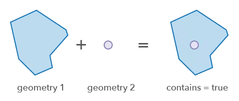
* Performs a relational operation to determine if one 2D geometry contains another 2D geometry.
|
|
3
|
-
* Geometry A contains geometry B
|
|
3
|
+
* Geometry A contains geometry B when B is the intersection of A and B.
|
|
4
4
|
* A contains B is equivalent to B within A. Geometry B can be non-simple geometry.
|
|
5
5
|
*
|
|
6
6
|
* 
|
|
@@ -1,5 +1,5 @@
|
|
|
1
1
|
/**
|
|
2
|
-
* Densifies 2D geometries by length, deviation and/or angle in a 2D plane. The result geometry contains segments less than or equal to `
|
|
2
|
+
* Densifies 2D geometries by length, deviation and/or angle in a 2D plane. The result geometry contains segments less than or equal to `maxSegmentLength`, and it will not contain curves.
|
|
3
3
|
* The piecewise approximation of curves will be within the specified deviation from the original curve,
|
|
4
4
|
* and the angle between tangent segments does not exceed the specified value.
|
|
5
5
|
*
|
|
@@ -36,18 +36,19 @@ export function differenceExecute(geometry: GeometryUnion, subtractor: GeometryU
|
|
|
36
36
|
export function execute(geometry: GeometryUnion, subtractor: GeometryUnion): GeometryWithoutMeshUnion | null | undefined;
|
|
37
37
|
|
|
38
38
|
/**
|
|
39
|
-
* Performs the
|
|
39
|
+
* Performs the topological difference operation on the geometry set.
|
|
40
40
|
*
|
|
41
41
|
* @param geometries - The set of geometry instances to be subtracted by the `subtractor`.
|
|
42
42
|
* All the geometries must have the same spatial reference.
|
|
43
43
|
* @param subtractor - The geometry on the right-hand side being subtracted.
|
|
44
|
-
* @returns Returns an array whose elements are the result of subtracting each input geometry
|
|
44
|
+
* @returns Returns an array whose elements are the result of subtracting `subtractor` from each input geometry in `geometries`.
|
|
45
|
+
* Individual entries may be `null` or `undefined`. Each result has the dimensions of its corresponding input geometry.
|
|
45
46
|
* @since 5.2
|
|
46
47
|
*/
|
|
47
48
|
export function differenceExecuteMany(geometries: GeometryUnion[], subtractor: GeometryUnion): (GeometryWithoutMeshUnion | null | undefined)[];
|
|
48
49
|
|
|
49
50
|
/**
|
|
50
|
-
* Performs the
|
|
51
|
+
* Performs the topological difference operation on the geometry set.
|
|
51
52
|
*
|
|
52
53
|
* @deprecated
|
|
53
54
|
* since 5.2. Refactor using \@arcgis/codemod or manually replace usages
|
|
@@ -55,7 +56,8 @@ export function differenceExecuteMany(geometries: GeometryUnion[], subtractor: G
|
|
|
55
56
|
* @param geometries - An array of geometries.
|
|
56
57
|
* All the geometries must have the same spatial reference.
|
|
57
58
|
* @param subtractor - The geometry to be subtracted from each and every geometry in `geometries`.
|
|
58
|
-
* @returns
|
|
59
|
+
* @returns Returns an array whose elements are the result of subtracting `subtractor` from each input geometry in `geometries`.
|
|
60
|
+
* Individual entries may be `null` or `undefined`. Each result has the dimensions of its corresponding input geometry.
|
|
59
61
|
*/
|
|
60
62
|
export function executeMany(geometries: GeometryUnion[], subtractor: GeometryUnion): (GeometryWithoutMeshUnion | null | undefined)[];
|
|
61
63
|
|
|
@@ -49,7 +49,7 @@ export function distanceExecute(geometry1: GeometryUnion, geometry2: GeometryUni
|
|
|
49
49
|
* @param geometry1 - The first input geometry.
|
|
50
50
|
* @param geometry2 - The second input geometry.
|
|
51
51
|
* @param options - Additional options.
|
|
52
|
-
* @returns The distance between the two geometries. Will return NaN if either input
|
|
52
|
+
* @returns The distance between the two geometries. Will return NaN if either input geometry is empty.
|
|
53
53
|
* @example
|
|
54
54
|
* // Calculate the planar distance between two points
|
|
55
55
|
* const distance = distanceExecute(point1, point2);
|
|
@@ -109,7 +109,7 @@ export function load(): Promise<void>;
|
|
|
109
109
|
|
|
110
110
|
/**
|
|
111
111
|
* Returns the nearest coordinate on the geometry to the given input point.
|
|
112
|
-
* The operator interprets all segments in
|
|
112
|
+
* The operator interprets all segments in a shape-preserving manner, that is, it treats segments as if they are densified with a small step in the input spatial reference and then the calculation is performed geodesically.
|
|
113
113
|
*
|
|
114
114
|
* @param geometry - The input geometry.
|
|
115
115
|
* @param point - The point used to search for the nearest coordinate in `geometry`.
|
|
@@ -128,7 +128,7 @@ export function geodesicProximityGetNearestCoordinate(geometry: GeometryUnion, p
|
|
|
128
128
|
|
|
129
129
|
/**
|
|
130
130
|
* Returns the nearest coordinate on the geometry to the given input point.
|
|
131
|
-
* The operator interprets all segments in
|
|
131
|
+
* The operator interprets all segments in a shape-preserving manner, that is, it treats segments as if they are densified with a small step in the input spatial reference and then the calculation is performed geodesically.
|
|
132
132
|
*
|
|
133
133
|
* @deprecated
|
|
134
134
|
* since 5.2. Refactor using \@arcgis/codemod or manually replace usages
|
|
@@ -151,7 +151,7 @@ export function getNearestCoordinate(geometry: GeometryUnion, point: Point, opti
|
|
|
151
151
|
* Returns the nearest vertex on the geometry.
|
|
152
152
|
*
|
|
153
153
|
* @param geometry - The input geometry.
|
|
154
|
-
* @param point - The point used to search for the nearest
|
|
154
|
+
* @param point - The point used to search for the nearest vertex in the input `geometry`.
|
|
155
155
|
* @param options - Additional options.
|
|
156
156
|
* @returns Returns the result of proximity operation.
|
|
157
157
|
* @since 5.2
|
|
@@ -172,7 +172,7 @@ export function geodesicProximityGetNearestVertex(geometry: GeometryUnion, point
|
|
|
172
172
|
* since 5.2. Refactor using \@arcgis/codemod or manually replace usages
|
|
173
173
|
* with [geodesicProximityGetNearestVertex()](https://developers.arcgis.com/javascript/latest/references/core/geometry/operators/geodesicProximityOperator/#geodesicProximityGetNearestVertex).
|
|
174
174
|
* @param geometry - The input geometry.
|
|
175
|
-
* @param point - The point used to search for the nearest
|
|
175
|
+
* @param point - The point used to search for the nearest vertex in the input `geometry`.
|
|
176
176
|
* @param options - Additional options.
|
|
177
177
|
* @returns Returns the result of proximity operation.
|
|
178
178
|
* @example
|
|
@@ -189,13 +189,13 @@ export function getNearestVertex(geometry: GeometryUnion, point: Point, options?
|
|
|
189
189
|
* Returns vertices of the geometry that are closer to the given point than the given radius.
|
|
190
190
|
*
|
|
191
191
|
* @param geometry - The input geometry.
|
|
192
|
-
* @param point - The point used to search for the nearest
|
|
192
|
+
* @param point - The point used to search for the nearest vertices in `geometry`.
|
|
193
193
|
* @param searchRadius - The distance to search from the `point` to the nearest vertices in the `geometry`.
|
|
194
194
|
* Unless the `unit` option is set, the default is meters.
|
|
195
195
|
* @param maxVertexCountToReturn - The maximum number of vertices that will be returned. Must be a positive number.
|
|
196
196
|
* @param options - Additional options.
|
|
197
197
|
* @returns The array of vertices that are in the given search radius to the point.
|
|
198
|
-
* The array is sorted by distance to the
|
|
198
|
+
* The array is sorted by distance to the query point, with the closest vertex first.
|
|
199
199
|
* When there are more than the `maxVertexCountToReturn` vertices to return, it returns the closest vertices.
|
|
200
200
|
* The array will be empty when `geometry` is empty.
|
|
201
201
|
* @since 5.2
|
|
@@ -216,13 +216,13 @@ export function geodesicProximityGetNearestVertices(geometry: GeometryUnion, poi
|
|
|
216
216
|
* since 5.2. Refactor using \@arcgis/codemod or manually replace usages
|
|
217
217
|
* with [geodesicProximityGetNearestVertices()](https://developers.arcgis.com/javascript/latest/references/core/geometry/operators/geodesicProximityOperator/#geodesicProximityGetNearestVertices).
|
|
218
218
|
* @param geometry - The input geometry.
|
|
219
|
-
* @param point - The point used to search for the nearest
|
|
219
|
+
* @param point - The point used to search for the nearest vertices in `geometry`.
|
|
220
220
|
* @param searchRadius - The distance to search from the `point` to the nearest vertices in the `geometry`.
|
|
221
221
|
* Unless the `unit` option is set, the default is meters.
|
|
222
222
|
* @param maxVertexCountToReturn - The maximum number of vertices that will be returned. Must be a positive number.
|
|
223
223
|
* @param options - Additional options.
|
|
224
224
|
* @returns The array of vertices that are in the given search radius to the point.
|
|
225
|
-
* The array is sorted by distance to the
|
|
225
|
+
* The array is sorted by distance to the query point, with the closest vertex first.
|
|
226
226
|
* When there are more than the `maxVertexCountToReturn` vertices to return, it returns the closest vertices.
|
|
227
227
|
* The array will be empty when `geometry` is empty.
|
|
228
228
|
* @example
|
|
@@ -67,8 +67,8 @@ export type Options = GraphicBufferOptions;
|
|
|
67
67
|
* * Miter joins are replaced with bevel when the ratio of the miter thickness to the buffer distance is greater than miter limit. The miter thickness is the distance from the vertex to the mitered corner of the buffer that this vertex generates.
|
|
68
68
|
* @param caps - Defines the buffer's shape at the end points of the geometries.
|
|
69
69
|
* * Points with square caps will be drawn as squares.
|
|
70
|
-
* * Open
|
|
71
|
-
* * Open
|
|
70
|
+
* * Open polyline paths with square caps degenerate to a point and will be drawn as squares (degenerate with zero tolerance).
|
|
71
|
+
* * Open polyline paths with round caps degenerate to a point and will be drawn as circles (degenerate with zero tolerance).
|
|
72
72
|
* @param options - Additional options.
|
|
73
73
|
* @returns Returns the buffered geometries.
|
|
74
74
|
* @since 5.2
|
|
@@ -79,7 +79,7 @@ export type Options = GraphicBufferOptions;
|
|
|
79
79
|
* [1000, 1500],
|
|
80
80
|
* "square",
|
|
81
81
|
* "round",
|
|
82
|
-
* 10,
|
|
82
|
+
* { miterLimit: 10 },
|
|
83
83
|
* );
|
|
84
84
|
*/
|
|
85
85
|
export function graphicBufferExecuteMany(geometries: GeometryUnion[], distances: number[], joins: "round" | "miter" | "bevel", caps: "round" | "butt" | "square", options?: GraphicBufferOptions): Polygon[];
|
|
@@ -102,8 +102,8 @@ export function graphicBufferExecuteMany(geometries: GeometryUnion[], distances:
|
|
|
102
102
|
* * Miter joins are replaced with bevel when the ratio of the miter thickness to the buffer distance is greater than miter limit. The miter thickness is the distance from the vertex to the mitered corner of the buffer that this vertex generates.
|
|
103
103
|
* @param caps - Defines the buffer's shape at the end points of the geometries.
|
|
104
104
|
* * Points with square caps will be drawn as squares.
|
|
105
|
-
* * Open
|
|
106
|
-
* * Open
|
|
105
|
+
* * Open polyline paths with square caps degenerate to a point and will be drawn as squares (degenerate with zero tolerance).
|
|
106
|
+
* * Open polyline paths with round caps degenerate to a point and will be drawn as circles (degenerate with zero tolerance).
|
|
107
107
|
* @param options - Additional options.
|
|
108
108
|
* @returns Returns the buffered geometries.
|
|
109
109
|
* @example
|
|
@@ -113,7 +113,7 @@ export function graphicBufferExecuteMany(geometries: GeometryUnion[], distances:
|
|
|
113
113
|
* [1000, 1500],
|
|
114
114
|
* "square",
|
|
115
115
|
* "round",
|
|
116
|
-
* 10,
|
|
116
|
+
* { miterLimit: 10 },
|
|
117
117
|
* );
|
|
118
118
|
*/
|
|
119
119
|
export function executeMany(geometries: GeometryUnion[], distances: number[], joins: "round" | "miter" | "bevel", caps: "round" | "butt" | "square", options?: GraphicBufferOptions): Polygon[];
|
|
@@ -14,7 +14,7 @@ import type { GeometryUnion, GeometryWithoutMeshUnion } from "../types.js";
|
|
|
14
14
|
*
|
|
15
15
|
* @param geometries - The set of geometries to integrate.
|
|
16
16
|
* All the geometries must have the same spatial reference.
|
|
17
|
-
* @returns Returns the result of the
|
|
17
|
+
* @returns Returns the result of the integration.
|
|
18
18
|
* The operation filters out degenerate segments and returns `null` for empty geometries.
|
|
19
19
|
* @since 5.2
|
|
20
20
|
* @example
|
|
@@ -31,7 +31,7 @@ export function integrateExecuteMany(geometries: GeometryUnion[]): (GeometryWith
|
|
|
31
31
|
* with [integrateExecuteMany()](https://developers.arcgis.com/javascript/latest/references/core/geometry/operators/integrateOperator/#integrateExecuteMany).
|
|
32
32
|
* @param geometries - The set of geometries to integrate.
|
|
33
33
|
* All the geometries must have the same spatial reference.
|
|
34
|
-
* @returns Returns the result of the
|
|
34
|
+
* @returns Returns the result of the integration.
|
|
35
35
|
* The operation filters out degenerate segments and returns `null` for empty geometries.
|
|
36
36
|
* @example
|
|
37
37
|
* // Integrate a set of geometries
|
|
@@ -1,6 +1,6 @@
|
|
|
1
1
|
/**
|
|
2
2
|
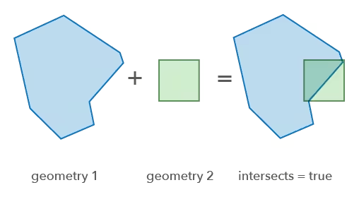
* Performs a relational operation to determine if one 2D geometry intersects another 2D geometry.
|
|
3
|
-
*
|
|
3
|
+
* Intersects is the same as not being disjoint.
|
|
4
4
|
* This operator can be used with non-simple geometries.
|
|
5
5
|
*
|
|
6
6
|
* 
|
|
@@ -30,7 +30,7 @@ export function intersectsAccelerateGeometry(geometry: GeometryUnion): boolean;
|
|
|
30
30
|
export function accelerateGeometry(geometry: GeometryUnion): boolean;
|
|
31
31
|
|
|
32
32
|
/**
|
|
33
|
-
*
|
|
33
|
+
* Performs the intersects operation on two geometries.
|
|
34
34
|
*
|
|
35
35
|
* @param geometry1 - The geometry that is tested for the intersects relationship to `geometry2`.
|
|
36
36
|
* @param geometry2 - The geometry being intersected.
|
|
@@ -43,7 +43,7 @@ export function accelerateGeometry(geometry: GeometryUnion): boolean;
|
|
|
43
43
|
export function intersectsExecute(geometry1: GeometryUnion, geometry2: GeometryUnion): boolean;
|
|
44
44
|
|
|
45
45
|
/**
|
|
46
|
-
*
|
|
46
|
+
* Performs the intersects operation on two geometries.
|
|
47
47
|
*
|
|
48
48
|
* @deprecated
|
|
49
49
|
* since 5.2. Refactor using \@arcgis/codemod or manually replace usages
|
|
@@ -11,7 +11,7 @@ import type { GeometryUnion } from "../types.js";
|
|
|
11
11
|
*
|
|
12
12
|
* @param geometries - The set of input geometries.
|
|
13
13
|
* All the geometries must have the same spatial reference.
|
|
14
|
-
* @returns Returns the
|
|
14
|
+
* @returns Returns the resulting polygons.
|
|
15
15
|
* @since 5.2
|
|
16
16
|
* @example
|
|
17
17
|
* // Perform the lines to polygons operation
|
|
@@ -27,7 +27,7 @@ export function linesToPolygonsExecuteMany(geometries: GeometryUnion[]): Polygon
|
|
|
27
27
|
* with [linesToPolygonsExecuteMany()](https://developers.arcgis.com/javascript/latest/references/core/geometry/operators/linesToPolygonsOperator/#linesToPolygonsExecuteMany).
|
|
28
28
|
* @param geometries - The set of input geometries.
|
|
29
29
|
* All the geometries must have the same spatial reference.
|
|
30
|
-
* @returns Returns the
|
|
30
|
+
* @returns Returns the resulting polygons.
|
|
31
31
|
* @example
|
|
32
32
|
* // Perform the lines to polygons operation
|
|
33
33
|
* const polygons = linesToPolygonsExecuteMany([polyline1, polyline2]);
|
|
@@ -18,7 +18,7 @@ import type { GeometryUnion, GeometryWithoutMeshUnion } from "../types.js";
|
|
|
18
18
|
* All the geometries must have the same spatial reference.
|
|
19
19
|
* @param startM - The M value to start the operation.
|
|
20
20
|
* @param endM - The M value to end the operation.
|
|
21
|
-
* @returns Returns the
|
|
21
|
+
* @returns Returns the resulting geometries.
|
|
22
22
|
* For 1-dimensional geometries, the result could be either point, multipoint, or polyline.
|
|
23
23
|
* For polylines, the result can be both polyline and multipoint.
|
|
24
24
|
* @since 5.2
|
|
@@ -39,7 +39,7 @@ export function locateBetweenExecuteMany(geometries: GeometryUnion[], startM: nu
|
|
|
39
39
|
* All the geometries must have the same spatial reference.
|
|
40
40
|
* @param startM - The M value to start the operation.
|
|
41
41
|
* @param endM - The M value to end the operation.
|
|
42
|
-
* @returns Returns the
|
|
42
|
+
* @returns Returns the resulting geometries.
|
|
43
43
|
* For 1-dimensional geometries, the result could be either point, multipoint, or polyline.
|
|
44
44
|
* For polylines, the result can be both polyline and multipoint.
|
|
45
45
|
* @example
|
|
@@ -1,7 +1,7 @@
|
|
|
1
1
|
/**
|
|
2
2
|
* Create a minimum bounding circle for the input geometry.
|
|
3
3
|
* The output is a polygon with a single closed circular segment containing curves.
|
|
4
|
-
* Implements
|
|
4
|
+
* Implements Welzl's algorithm using a greedy heuristic with expected O(n) time complexity.
|
|
5
5
|
*
|
|
6
6
|
* > [!WARNING]
|
|
7
7
|
* >
|
|
@@ -34,7 +34,7 @@ export type Options = MultiPartToSinglePartOptions;
|
|
|
34
34
|
* All the geometries must have the same spatial reference.
|
|
35
35
|
* @param options - Additional options.
|
|
36
36
|
* @returns Returns the single part geometries.
|
|
37
|
-
* For non-simple polygons, the output of the method is not guaranteed to be correct if the `
|
|
37
|
+
* For non-simple polygons, the output of the method is not guaranteed to be correct if the `simplifyPolygons` option is set to `false`.
|
|
38
38
|
* In that case, the method may either throw an error, or produce some output which is not guaranteed to be correct.
|
|
39
39
|
* @since 5.2
|
|
40
40
|
* @example
|
|
@@ -55,7 +55,7 @@ export function multiPartToSinglePartExecuteMany(geometries: GeometryUnion[], op
|
|
|
55
55
|
* All the geometries must have the same spatial reference.
|
|
56
56
|
* @param options - Additional options.
|
|
57
57
|
* @returns Returns the single part geometries.
|
|
58
|
-
* For non-simple polygons, the output of the method is not guaranteed to be correct if the `
|
|
58
|
+
* For non-simple polygons, the output of the method is not guaranteed to be correct if the `simplifyPolygons` option is set to `false`.
|
|
59
59
|
* In that case, the method may either throw an error, or produce some output which is not guaranteed to be correct.
|
|
60
60
|
* @example
|
|
61
61
|
* // Convert multipart geometries to single part geometries
|
|
@@ -45,7 +45,7 @@ export type FindSlicesByAreaOptions = PolygonSlicerFindSlicesByAreaOptions;
|
|
|
45
45
|
*
|
|
46
46
|
* @param polygon - The input polygon.
|
|
47
47
|
* @param partCount - The number of parts to slice into.
|
|
48
|
-
* @param remainingArea - The size of the remaining piece of the uncut polygon. Pass zero
|
|
48
|
+
* @param remainingArea - The size of the remaining piece of the uncut polygon. Pass zero if you want to slice the whole polygon.
|
|
49
49
|
* Unless the `unit` option is set, the default is the spatial reference unit of `polygon`.
|
|
50
50
|
* @param options - Additional options.
|
|
51
51
|
* @returns Returns the y-coordinate set for the slice positions sorted in increasing y-order. The set can be used as input to the
|
|
@@ -65,7 +65,7 @@ export function polygonSlicerFindSlicesByArea(polygon: Polygon, partCount: numbe
|
|
|
65
65
|
* with [polygonSlicerFindSlicesByArea()](https://developers.arcgis.com/javascript/latest/references/core/geometry/operators/polygonSlicerOperator/#polygonSlicerFindSlicesByArea).
|
|
66
66
|
* @param polygon - The input polygon.
|
|
67
67
|
* @param partCount - The number of parts to slice into.
|
|
68
|
-
* @param remainingArea - The size of the remaining piece of the uncut polygon. Pass zero
|
|
68
|
+
* @param remainingArea - The size of the remaining piece of the uncut polygon. Pass zero if you want to slice the whole polygon.
|
|
69
69
|
* Unless the `unit` option is set, the default is the spatial reference unit of `polygon`.
|
|
70
70
|
* @param options - Additional options.
|
|
71
71
|
* @returns Returns the y-coordinate set for the slice positions sorted in increasing y-order. The set can be used as input to the
|
|
@@ -135,7 +135,7 @@ export function execute(geometry: GeometryUnion, outSpatialReference: SpatialRef
|
|
|
135
135
|
* All the geometries must have the same spatial reference.
|
|
136
136
|
* @param outSpatialReference - The spatial reference to which the input geometry is projected.
|
|
137
137
|
* @param options - Additional options.
|
|
138
|
-
* @returns Returns
|
|
138
|
+
* @returns Returns an array of projected geometries, and individual entries may be `null` or `undefined`.
|
|
139
139
|
* @since 5.2
|
|
140
140
|
*/
|
|
141
141
|
export function projectExecuteMany(geometries: GeometryUnion[], outSpatialReference: SpatialReference, options?: ProjectOptions): (GeometryWithoutMeshUnion | null | undefined)[];
|
|
@@ -150,7 +150,7 @@ export function projectExecuteMany(geometries: GeometryUnion[], outSpatialRefere
|
|
|
150
150
|
* All the geometries must have the same spatial reference.
|
|
151
151
|
* @param outSpatialReference - The spatial reference to which the input geometry is projected.
|
|
152
152
|
* @param options - Additional options.
|
|
153
|
-
* @returns Returns
|
|
153
|
+
* @returns Returns an array of projected geometries, and individual entries may be `null` or `undefined`.
|
|
154
154
|
*/
|
|
155
155
|
export function executeMany(geometries: GeometryUnion[], outSpatialReference: SpatialReference, options?: ProjectOptions): (GeometryWithoutMeshUnion | null | undefined)[];
|
|
156
156
|
|