node-red-contrib-web-worldmap 2.39.0 → 2.40.0
This diff represents the content of publicly available package versions that have been released to one of the supported registries. The information contained in this diff is provided for informational purposes only and reflects changes between package versions as they appear in their respective public registries.
- package/CHANGELOG.md +1 -0
- package/README.md +11 -2
- package/package.json +3 -2
- package/worldmap/worldmap.js +68 -1
- package/worldmap.html +2 -2
package/CHANGELOG.md
CHANGED
|
@@ -1,5 +1,6 @@
|
|
|
1
1
|
### Change Log for Node-RED Worldmap
|
|
2
2
|
|
|
3
|
+
- v2.40.0 - Add handling for TAK event points from TAK ingest node.
|
|
3
4
|
- v2.39.0 - Add client timezone to connect message. PR #245
|
|
4
5
|
- v2.38.3 - Better fix for geojson multipoint icons.
|
|
5
6
|
- v2.38.1 - Fix for geojson multipoint icons.
|
package/README.md
CHANGED
|
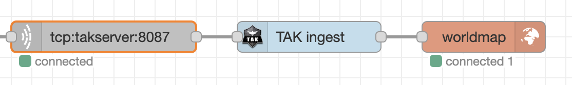
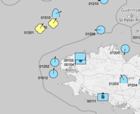
@@ -13,6 +13,7 @@ Feel free to [ can use the [TAK ingest node](https://flows.nodered.org/node/node-red-contrib-tak-registration) to create a JSON formatted TAK event object, received from a TAK server. This can be fed directly into the worldmap node.
|
|
129
|
+
|
|
130
|
+
|
|
131
|
+
|
|
132
|
+
|
|
133
|
+
|
|
125
134
|
### Areas, Rectangles, Lines, and GreatCircles
|
|
126
135
|
|
|
127
136
|
If the msg.payload contains an **area** property - that is an array of co-ordinates, e.g.
|
|
@@ -698,7 +707,7 @@ and use a url like `"url": "http://localhost:1882/?map=/maps/my-app.map",`
|
|
|
698
707
|
|
|
699
708
|
To use a vector mbtiles server like **MapTiler** then you can download your mbtiles file into a directory and then from that directory run
|
|
700
709
|
```
|
|
701
|
-
docker run --name maptiler -d -v $(pwd):/data -p 1884:8080 maptiler/tileserver-gl -p 8080
|
|
710
|
+
docker run --name maptiler -d -v $(pwd):/data -p 1884:8080 maptiler/tileserver-gl -p 8080 --mbtiles yourMapFile.mbtiles
|
|
702
711
|
```
|
|
703
712
|
and use a url like `"url": "http://localhost:1884/styles/basic-preview/{z}/{x}/{y}.png"`
|
|
704
713
|
|
package/package.json
CHANGED
|
@@ -1,6 +1,6 @@
|
|
|
1
1
|
{
|
|
2
2
|
"name": "node-red-contrib-web-worldmap",
|
|
3
|
-
"version": "2.
|
|
3
|
+
"version": "2.40.0",
|
|
4
4
|
"description": "A Node-RED node to provide a web page of a world map for plotting things on.",
|
|
5
5
|
"dependencies": {
|
|
6
6
|
"@turf/bezier-spline": "~6.5.0",
|
|
@@ -24,7 +24,8 @@
|
|
|
24
24
|
"keywords": [
|
|
25
25
|
"node-red",
|
|
26
26
|
"map",
|
|
27
|
-
"world"
|
|
27
|
+
"world",
|
|
28
|
+
"tak"
|
|
28
29
|
],
|
|
29
30
|
"node-red": {
|
|
30
31
|
"version": ">=1.0.0",
|
package/worldmap/worldmap.js
CHANGED
|
@@ -18,7 +18,7 @@ var menuOpen = false;
|
|
|
18
18
|
var clusterAt = 0;
|
|
19
19
|
var maxage = 900; // default max age of icons on map in seconds - cleared after 10 mins
|
|
20
20
|
var baselayername = "OSM grey"; // Default base layer OSM but uniform grey
|
|
21
|
-
var pagefoot = " © DCJ
|
|
21
|
+
var pagefoot = " © DCJ 2023"
|
|
22
22
|
var inIframe = false;
|
|
23
23
|
var showUserMenu = true;
|
|
24
24
|
var showLayerMenu = true;
|
|
@@ -117,12 +117,23 @@ var handleData = function(data) {
|
|
|
117
117
|
}
|
|
118
118
|
}
|
|
119
119
|
if (data.command) { doCommand(data.command); delete data.command; }
|
|
120
|
+
|
|
121
|
+
// handle raw geojson type msg
|
|
120
122
|
if (data.hasOwnProperty("type") && data.type.indexOf("Feature") === 0) {
|
|
121
123
|
if (data.hasOwnProperty('properties') && data.properties.hasOwnProperty('title')) {
|
|
122
124
|
doGeojson(data.properties.title,data)
|
|
123
125
|
}
|
|
124
126
|
else { doGeojson("geojson",data); }
|
|
125
127
|
}
|
|
128
|
+
// handle TAK json (from tak-ingest node or fastxml node)
|
|
129
|
+
else if (data.hasOwnProperty("event") && data.event.hasOwnProperty("point")) {
|
|
130
|
+
doTAKjson(data.event);
|
|
131
|
+
}
|
|
132
|
+
// handle TAK json (from multicast Protobuf)
|
|
133
|
+
else if (data.hasOwnProperty("cotEvent") && data.cotEvent.hasOwnProperty("lat") && data.cotEvent.hasOwnProperty("lon")) {
|
|
134
|
+
doTAKMCjson(data.cotEvent);
|
|
135
|
+
}
|
|
136
|
+
// handle default worldmap json msg
|
|
126
137
|
else if (data.hasOwnProperty("name")) { setMarker(data); }
|
|
127
138
|
else {
|
|
128
139
|
if (JSON.stringify(data) !== '{}') {
|
|
@@ -2910,3 +2921,59 @@ function doGeojson(n,g,l,o) {
|
|
|
2910
2921
|
layers[lay].addLayer(markers[n]);
|
|
2911
2922
|
map.addLayer(layers[lay]);
|
|
2912
2923
|
}
|
|
2924
|
+
|
|
2925
|
+
// handle TAK messages from TAK server tcp - XML->JSON
|
|
2926
|
+
function doTAKjson(p) {
|
|
2927
|
+
// console.log("TAK event",p);
|
|
2928
|
+
if (p.type.indexOf('a') === 0) {
|
|
2929
|
+
var d = {};
|
|
2930
|
+
d.lat = Number(p.point.lat);
|
|
2931
|
+
d.lon = Number(p.point.lon);
|
|
2932
|
+
d.group = p.detail?.__group?.name;
|
|
2933
|
+
d.role = p.detail?.__group?.role;
|
|
2934
|
+
d.type = p.type;
|
|
2935
|
+
d.uid = p.uid;
|
|
2936
|
+
d.name = p.detail?.contact?.callsign || p.uid;
|
|
2937
|
+
d.hdg = p.detail?.track?.course;
|
|
2938
|
+
d.speed = p.detail?.track?.speed;
|
|
2939
|
+
var i = d.type.split('-').join('').toUpperCase();
|
|
2940
|
+
if (i[0] === 'A') { i = 'S' + i.substr(1,2) + 'P' + i.substr(3); }
|
|
2941
|
+
d.SIDC = (i + '------------').substr(0,12);
|
|
2942
|
+
d.timestamp = Date.parse(p.time);
|
|
2943
|
+
d.ttl = Date.parse(p.stale);
|
|
2944
|
+
// d.now = Date.now();
|
|
2945
|
+
d.alt = Number(p.point.hae) || 9999999;
|
|
2946
|
+
setMarker(d);
|
|
2947
|
+
}
|
|
2948
|
+
else {
|
|
2949
|
+
console.log("Skip TAK type",p.type);
|
|
2950
|
+
}
|
|
2951
|
+
}
|
|
2952
|
+
|
|
2953
|
+
// handle TAK messages from TAK Multicast - Protobuf->JSON
|
|
2954
|
+
function doTAKMCjson(p) {
|
|
2955
|
+
// console.log("TAK Multicast event",p);
|
|
2956
|
+
if (p.type.indexOf('a') === 0) {
|
|
2957
|
+
var d = {};
|
|
2958
|
+
d.lat = p.lat;
|
|
2959
|
+
d.lon = p.lon;
|
|
2960
|
+
d.group = p.detail?.group?.name;
|
|
2961
|
+
d.role = p.detail?.group?.role;
|
|
2962
|
+
d.type = p.type;
|
|
2963
|
+
d.uid = p.uid;
|
|
2964
|
+
d.name = p.detail?.contact?.callsign || p.uid;
|
|
2965
|
+
d.hdg = p.detail?.track?.course;
|
|
2966
|
+
d.speed = p.detail?.track?.speed;
|
|
2967
|
+
var i = d.type.split('-').join('').toUpperCase();
|
|
2968
|
+
if (i[0] === 'A') { i = 'S' + i.substr(1,2) + 'P' + i.substr(3); }
|
|
2969
|
+
d.SIDC = (i + '------------').substr(0,12);
|
|
2970
|
+
d.timestamp = Number(p.sendTime);
|
|
2971
|
+
d.ttl = Number(p.staleTime);
|
|
2972
|
+
// d.now = Date.now();
|
|
2973
|
+
d.alt = p.hae || 9999999;
|
|
2974
|
+
setMarker(d);
|
|
2975
|
+
}
|
|
2976
|
+
else {
|
|
2977
|
+
console.log("Skip TAK type",p.type);
|
|
2978
|
+
}
|
|
2979
|
+
}
|
package/worldmap.html
CHANGED
|
@@ -146,7 +146,7 @@ If <i>Web Path</i> is left empty, then by default <code>⌘⇧m</code> - <code>c
|
|
|
146
146
|
<p>Icons of type <i>plane</i>, <i>ship</i>, <i>car</i>, <i>uav</i> or <i>arrow</i> will use built in SVG icons that align to the
|
|
147
147
|
<code>bearing</code> value.</p>
|
|
148
148
|
<p>Font Awesome (<a href="https://fontawesome.com/v4.7.0/icons/" target="_new">fa-icons 4.7</a>) can also be used, as can
|
|
149
|
-
NATO symbology codes (<a href="https://spatialillusions.com/unitgenerator/">SIDC</a>), or <a href="https://github.com/dceejay/RedMap/blob/master/emojilist.md" target="_new">:emoji name:</a>,
|
|
149
|
+
NATO symbology codes (<a href="https://www.spatialillusions.com/unitgenerator-legacy/">SIDC</a>), or <a href="https://github.com/dceejay/RedMap/blob/master/emojilist.md" target="_new">:emoji name:</a>,
|
|
150
150
|
or the url of a small icon image (32x32)</p>
|
|
151
151
|
<p>See the <a href="https://www.npmjs.com/package/node-red-contrib-web-worldmap" target="_new">README</a> for further
|
|
152
152
|
details and examples of icons and commands for drawing <b>lines</b> and <b>areas</b>, and to <b>add layers</b> and
|
|
@@ -312,7 +312,7 @@ If <i>Web Path</i> is left empty, then by default <code>⌘⇧m</code> - <code>c
|
|
|
312
312
|
<p>Icons of type <i>plane</i>, <i>ship</i>, <i>car</i>, <i>uav</i> or <i>arrow</i> will use built in SVG icons that align to the
|
|
313
313
|
<code>bearing</code> value.</p>
|
|
314
314
|
<p>Font Awesome (<a href="https://fontawesome.com/v4.7.0/icons/" target="_new">fa-icons 4.7</a>) can also be used, as can
|
|
315
|
-
NATO symbology codes (<a href="https://spatialillusions.com/unitgenerator/">SIDC</a>), or <a href="https://github.com/dceejay/RedMap/blob/master/emojilist.md" target="_new">:emoji name:</a>,
|
|
315
|
+
NATO symbology codes (<a href="https://www.spatialillusions.com/unitgenerator-legacy/">SIDC</a>), or <a href="https://github.com/dceejay/RedMap/blob/master/emojilist.md" target="_new">:emoji name:</a>,
|
|
316
316
|
or the url of a small icon image (32x32)</p>
|
|
317
317
|
<p>See the <a href="https://www.npmjs.com/package/node-red-contrib-web-worldmap" target="_new">README</a> for further
|
|
318
318
|
details and examples of icons and commands for drawing <b>lines</b> and <b>areas</b>, and to <b>add layers</b> and
|