@arcgis/core 5.2.0-next.167 → 5.2.0-next.169
This diff represents the content of publicly available package versions that have been released to one of the supported registries. The information contained in this diff is provided for informational purposes only and reflects changes between package versions as they appear in their respective public registries.
- package/Map.d.ts +6 -0
- package/assets/esri/core/workers/RemoteClient.js +1 -1
- package/assets/esri/core/workers/chunks/057f245d70e57a1bcb46.js +1 -0
- package/assets/esri/core/workers/chunks/{1419bf346978b81b08cc.js → 094eb9677cdebfaa9e1b.js} +1 -1
- package/assets/esri/core/workers/chunks/0d52e1b6d38f2670658c.js +1 -0
- package/assets/esri/core/workers/chunks/0f7455dbe8c2ee464194.js +1 -0
- package/assets/esri/core/workers/chunks/10878932826ddb60fac4.js +1 -0
- package/assets/esri/core/workers/chunks/144bad0c2415c345736a.js +1 -0
- package/assets/esri/core/workers/chunks/1a614bac5db42c6263f8.js +1 -0
- package/assets/esri/core/workers/chunks/{99a0a434ea2162166754.js → 2095f220dc2b8f8f62db.js} +1 -1
- package/assets/esri/core/workers/chunks/{5daa9429808ca31279f2.js → 216a239142dfe1306c6c.js} +1 -1
- package/assets/esri/core/workers/chunks/25c3be410d1c03f8f39d.js +1 -0
- package/assets/esri/core/workers/chunks/294276ed397023dcda44.js +1 -0
- package/assets/esri/core/workers/chunks/2a2a4650dd9b953d317c.js +1 -0
- package/assets/esri/core/workers/chunks/2b6684d057d9ad17ac13.js +1 -0
- package/assets/esri/core/workers/chunks/{ad96132bc89671e595f3.js → 2d3e0e4442dbc6ec6def.js} +1 -1
- package/assets/esri/core/workers/chunks/2d83ba260dd6bbe38206.js +1 -0
- package/assets/esri/core/workers/chunks/{69d5f8ef78b9b8b3d33d.js → 3286cf2afeb7f48564d9.js} +1 -1
- package/assets/esri/core/workers/chunks/3321cb0d4cb68b2ec8bf.js +1 -0
- package/assets/esri/core/workers/chunks/{e99c8c71c757bb161d87.js → 3636c2ac9b77950776d6.js} +1 -1
- package/assets/esri/core/workers/chunks/367b2f25cfe37847a48d.js +1 -0
- package/assets/esri/core/workers/chunks/379ef56f6b32494832a6.js +1 -0
- package/assets/esri/core/workers/chunks/3c881b1adc8a5dea9a90.js +1 -0
- package/assets/esri/core/workers/chunks/{6a2562cc00727155fc01.js → 4024becaf4012c1f15a7.js} +1 -1
- package/assets/esri/core/workers/chunks/435ad7e6ed326da2b969.js +1 -0
- package/assets/esri/core/workers/chunks/4419732baf3459a80e6d.js +1 -0
- package/assets/esri/core/workers/chunks/46f0510846a309a390ca.js +1 -0
- package/assets/esri/core/workers/chunks/4e17665dd9048c300d87.js +1 -0
- package/assets/esri/core/workers/chunks/509a74e9334f31b931d4.js +1 -0
- package/assets/esri/core/workers/chunks/50e8943d2c0b96fab2c1.js +1 -0
- package/assets/esri/core/workers/chunks/5396b6e99a0546a25d19.js +1 -0
- package/assets/esri/core/workers/chunks/546f5f57c9249627bb89.js +1 -0
- package/assets/esri/core/workers/chunks/561c48cb4d49b150765b.js +1 -0
- package/assets/esri/core/workers/chunks/{d90a3bfd45b5ed4092e0.js → 590fe0f56bc4c33a50e7.js} +1 -1
- package/assets/esri/core/workers/chunks/5d42f0898bf30ae940ea.js +1 -0
- package/assets/esri/core/workers/chunks/5f1cb79aec9c4a9b7ddc.js +29 -0
- package/assets/esri/core/workers/chunks/{5d2f043ebe1051326c56.js → 63b5418a1c3fe0a97a86.js} +1 -1
- package/assets/esri/core/workers/chunks/63c3a573dfe703056f8f.js +1 -0
- package/assets/esri/core/workers/chunks/673c61c964524150d9bc.js +1 -0
- package/assets/esri/core/workers/chunks/692f0093c444fcc752b5.js +1 -0
- package/assets/esri/core/workers/chunks/69627b2634da64dd885f.js +1 -0
- package/assets/esri/core/workers/chunks/{e6d10136bc08aef255ff.js → 712559f121f76c4e71ab.js} +1 -1
- package/assets/esri/core/workers/chunks/71a51795f715332fb4fe.js +1 -0
- package/assets/esri/core/workers/chunks/735c1dffc3439bdba3cc.js +1 -0
- package/assets/esri/core/workers/chunks/7862abd24fb5c3b12e6b.js +1 -0
- package/assets/esri/core/workers/chunks/{44d5508042cacdfcac47.js → 7d2be06dfbd92c8b9484.js} +1 -1
- package/assets/esri/core/workers/chunks/7f5b887a753bb67c8486.js +1 -0
- package/assets/esri/core/workers/chunks/822f83d7c09ef0a9bbdf.js +1 -0
- package/assets/esri/core/workers/chunks/849f446c718e892f39ce.js +1 -0
- package/assets/esri/core/workers/chunks/8d86b0cb0e004ad72040.js +1 -0
- package/assets/esri/core/workers/chunks/{76196c414e48834f7b92.js → 8f008eedb11685ee2048.js} +1 -1
- package/assets/esri/core/workers/chunks/98760040f0c9d47c718d.js +1 -0
- package/assets/esri/core/workers/chunks/{4b99b4cf729881e616bc.js → 98d1efb6f2439c6344cf.js} +1 -1
- package/assets/esri/core/workers/chunks/{18f20fd43ec9ce03cef1.js → 9e04703ee5f5ec47db43.js} +1 -1
- package/assets/esri/core/workers/chunks/9e0b0262dec496451762.js +1 -0
- package/assets/esri/core/workers/chunks/{23fd4de56de352f63e2d.js → a2196a49f89d57a0a1c7.js} +1 -1
- package/assets/esri/core/workers/chunks/{89c8b0f684c1f27d149e.js → a2f0894218e665780a21.js} +1 -1
- package/assets/esri/core/workers/chunks/a79cae328e866272754a.js +1 -0
- package/assets/esri/core/workers/chunks/a85cdafbaf1848bb924b.js +1 -0
- package/assets/esri/core/workers/chunks/b01688ccc29d33bfc82d.js +1 -0
- package/assets/esri/core/workers/chunks/b0a612d8ffa5c46d7db4.js +1 -0
- package/assets/esri/core/workers/chunks/b5eff28cf482d920b9ea.js +1 -0
- package/assets/esri/core/workers/chunks/b70885deebc6106597ad.js +1 -0
- package/assets/esri/core/workers/chunks/bedaa5e64ed81803829a.js +1 -0
- package/assets/esri/core/workers/chunks/{a88f346786b04bd194dc.js → c0b38f8c808d434af5f6.js} +1 -1
- package/assets/esri/core/workers/chunks/c1cf3edce15f09648eb4.js +1 -0
- package/assets/esri/core/workers/chunks/c249a91dd23104723fab.js +1 -0
- package/assets/esri/core/workers/chunks/c45edd0a7d57263bb7d6.js +1 -0
- package/assets/esri/core/workers/chunks/c4bbe4707e90b7cd0379.js +1 -0
- package/assets/esri/core/workers/chunks/c52466eb1f3c33ae1f5a.js +1 -0
- package/assets/esri/core/workers/chunks/c570b90995c65bbb2e14.js +1 -0
- package/assets/esri/core/workers/chunks/c576bef77e34920af188.js +1 -0
- package/assets/esri/core/workers/chunks/c7699edd14497d174445.js +1 -0
- package/assets/esri/core/workers/chunks/c80a3b039e510c118399.js +1 -0
- package/assets/esri/core/workers/chunks/{196979cc6a765be3c5cd.js → c88a70f68c8ce8c30e9b.js} +1 -1
- package/assets/esri/core/workers/chunks/c9feffb9884cfed52c4b.js +1 -0
- package/assets/esri/core/workers/chunks/caaf6306cc73f618d27d.js +1 -0
- package/assets/esri/core/workers/chunks/{b704f489d0f072a0bfcd.js → ccd19c490ca24db6ffb1.js} +1 -1
- package/assets/esri/core/workers/chunks/cdacc3e42f01c3b852d6.js +1 -0
- package/assets/esri/core/workers/chunks/d1d6154b4af1c9cc497b.js +1 -0
- package/assets/esri/core/workers/chunks/d20dcd4ce4b0111d924f.js +1 -0
- package/assets/esri/core/workers/chunks/{784a2fba3e18286958d1.js → d56fdf5ce5ff53dc0e69.js} +1 -1
- package/assets/esri/core/workers/chunks/d7cf32a8c6060a208f06.js +1 -0
- package/assets/esri/core/workers/chunks/daae21cf77864f3293ef.js +1 -0
- package/assets/esri/core/workers/chunks/dd08dff19a2ffd36f284.js +1 -0
- package/assets/esri/core/workers/chunks/de3f140058aa0b907b65.js +1 -0
- package/assets/esri/core/workers/chunks/df375d1b0dab5ecbd1be.js +1 -0
- package/assets/esri/core/workers/chunks/{e2775b4b753306dc8477.js → df7603ef7d2a7cbeaaa2.js} +1 -1
- package/assets/esri/core/workers/chunks/e9cdb0b0f074583edebd.js +1 -0
- package/assets/esri/core/workers/chunks/eaab787a5f2445be5e5a.js +1 -0
- package/assets/esri/core/workers/chunks/edd36a1fc80b1d29907e.js +1 -0
- package/assets/esri/core/workers/chunks/{444e5f214abce3d607cd.js → eeb068c265bd3a22a8c1.js} +1 -1
- package/assets/esri/core/workers/chunks/f2cfee8a761ae91f7a3e.js +1 -0
- package/assets/esri/core/workers/chunks/f3fdf75843ade0ca591e.js +1 -0
- package/assets/esri/core/workers/chunks/f5cc78291b53931b91e8.js +1 -0
- package/assets/esri/core/workers/chunks/f9dc38761b314d33890f.js +1 -0
- package/assets/esri/core/workers/chunks/feb6e041dd0aa1c59c31.js +1 -0
- package/assets/esri/widgets/BatchAttributeForm/t9n/messages.ar.json +1 -1
- package/assets/esri/widgets/BatchAttributeForm/t9n/messages.bg.json +1 -1
- package/assets/esri/widgets/BatchAttributeForm/t9n/messages.bs.json +1 -1
- package/assets/esri/widgets/BatchAttributeForm/t9n/messages.ca.json +1 -1
- package/assets/esri/widgets/BatchAttributeForm/t9n/messages.cs.json +1 -1
- package/assets/esri/widgets/BatchAttributeForm/t9n/messages.da.json +1 -1
- package/assets/esri/widgets/BatchAttributeForm/t9n/messages.de.json +1 -1
- package/assets/esri/widgets/BatchAttributeForm/t9n/messages.el.json +1 -1
- package/assets/esri/widgets/BatchAttributeForm/t9n/messages.es.json +1 -1
- package/assets/esri/widgets/BatchAttributeForm/t9n/messages.et.json +1 -1
- package/assets/esri/widgets/BatchAttributeForm/t9n/messages.fi.json +1 -1
- package/assets/esri/widgets/BatchAttributeForm/t9n/messages.fr.json +1 -1
- package/assets/esri/widgets/BatchAttributeForm/t9n/messages.he.json +1 -1
- package/assets/esri/widgets/BatchAttributeForm/t9n/messages.hr.json +1 -1
- package/assets/esri/widgets/BatchAttributeForm/t9n/messages.hu.json +1 -1
- package/assets/esri/widgets/BatchAttributeForm/t9n/messages.id.json +1 -1
- package/assets/esri/widgets/BatchAttributeForm/t9n/messages.it.json +1 -1
- package/assets/esri/widgets/BatchAttributeForm/t9n/messages.ja.json +1 -1
- package/assets/esri/widgets/BatchAttributeForm/t9n/messages.ko.json +1 -1
- package/assets/esri/widgets/BatchAttributeForm/t9n/messages.lt.json +1 -1
- package/assets/esri/widgets/BatchAttributeForm/t9n/messages.lv.json +1 -1
- package/assets/esri/widgets/BatchAttributeForm/t9n/messages.nl.json +1 -1
- package/assets/esri/widgets/BatchAttributeForm/t9n/messages.no.json +1 -1
- package/assets/esri/widgets/BatchAttributeForm/t9n/messages.pl.json +1 -1
- package/assets/esri/widgets/BatchAttributeForm/t9n/messages.pt-BR.json +1 -1
- package/assets/esri/widgets/BatchAttributeForm/t9n/messages.pt-PT.json +1 -1
- package/assets/esri/widgets/BatchAttributeForm/t9n/messages.ro.json +1 -1
- package/assets/esri/widgets/BatchAttributeForm/t9n/messages.ru.json +1 -1
- package/assets/esri/widgets/BatchAttributeForm/t9n/messages.sk.json +1 -1
- package/assets/esri/widgets/BatchAttributeForm/t9n/messages.sl.json +1 -1
- package/assets/esri/widgets/BatchAttributeForm/t9n/messages.sr.json +1 -1
- package/assets/esri/widgets/BatchAttributeForm/t9n/messages.sv.json +1 -1
- package/assets/esri/widgets/BatchAttributeForm/t9n/messages.th.json +1 -1
- package/assets/esri/widgets/BatchAttributeForm/t9n/messages.tr.json +1 -1
- package/assets/esri/widgets/BatchAttributeForm/t9n/messages.uk.json +1 -1
- package/assets/esri/widgets/BatchAttributeForm/t9n/messages.vi.json +1 -1
- package/assets/esri/widgets/BatchAttributeForm/t9n/messages.zh-CN.json +1 -1
- package/assets/esri/widgets/BatchAttributeForm/t9n/messages.zh-HK.json +1 -1
- package/assets/esri/widgets/BatchAttributeForm/t9n/messages.zh-TW.json +1 -1
- package/config.js +1 -1
- package/core/workers/workers.js +2 -2
- package/core/workers.d.ts +1 -1
- package/form/elements/inputs/DynamicChoiceInput.d.ts +2 -2
- package/geometry/operators/containsOperator.d.ts +1 -1
- package/geometry/operators/densifyOperator.d.ts +1 -1
- package/geometry/operators/differenceOperator.d.ts +6 -4
- package/geometry/operators/distanceOperator.d.ts +1 -1
- package/geometry/operators/geodesicProximityOperator.d.ts +8 -8
- package/geometry/operators/graphicBufferOperator.d.ts +6 -6
- package/geometry/operators/integrateOperator.d.ts +2 -2
- package/geometry/operators/intersectsOperator.d.ts +3 -3
- package/geometry/operators/linesToPolygonsOperator.d.ts +2 -2
- package/geometry/operators/locateBetweenOperator.d.ts +2 -2
- package/geometry/operators/minimumBoundingCircleOperator.d.ts +1 -1
- package/geometry/operators/multiPartToSinglePartOperator.d.ts +2 -2
- package/geometry/operators/polygonSlicerOperator.d.ts +2 -2
- package/geometry/operators/projectOperator.d.ts +2 -2
- package/geometry/operators/proximityOperator.d.ts +15 -15
- package/geometry/operators/shapePreservingProjectOperator.d.ts +2 -2
- package/geometry/operators/simplifyOperator.d.ts +2 -2
- package/geometry/operators/support/GeographicTransformationStep.d.ts +3 -3
- package/geometry/operators/support/Transformation.d.ts +8 -8
- package/geometry/operators/support/geographicTransformationUtils.d.ts +3 -3
- package/geometry/operators/symmetricDifferenceOperator.d.ts +2 -2
- package/geometry/operators/withinOperator.d.ts +3 -3
- package/graphic/MapNotesGraphicOrigin.d.ts +1 -0
- package/kernel.js +1 -1
- package/layers/ElevationLayer.d.ts +6 -2
- package/layers/GeospatialPDFLayer.d.ts +2 -2
- package/layers/ParquetLayer.d.ts +1 -1
- package/layers/VectorTileLayer.d.ts +10 -1
- package/layers/graphics/sources/support/ParquetSourceWorker.js +1 -1
- package/layers/orientedImagery/core/coverageUtils.js +1 -1
- package/layers/orientedImagery/transformations/imageToWorld.js +1 -1
- package/layers/orientedImagery/transformations/rectifyMapPoint.js +1 -1
- package/layers/orientedImagery/transformations/rotationUtils.js +2 -0
- package/layers/orientedImagery/transformations/utils.js +1 -1
- package/package.json +2 -2
- package/popup/FeaturesModel.js +1 -1
- package/popup/support/featureUtils.js +1 -1
- package/rest/featureService/FeatureService.d.ts +0 -5
- package/rest/networks/support/TraceLocation.d.ts +2 -1
- package/rest/networks/support/TraceResult.d.ts +0 -4
- package/rest/support/OutDistance.d.ts +0 -1
- package/smartMapping/statistics/histogramForTimeSeries.js +1 -1
- package/smartMapping/statistics/summaryStatisticsForTimeSeries.js +1 -1
- package/support/BasemapStyle.d.ts +2 -2
- package/symbols/cim/types.d.ts +7 -9
- package/views/2d/engine/webgl/collisions/LabelMetric.js +1 -1
- package/views/2d/engine/webgl/collisions/LabelStore.js +1 -1
- package/views/2d/engine/webgl/shaderGraph/techniques/mesh/MeshWriterVertexPack.js +1 -1
- package/views/2d/layers/features/FeatureContainer.js +1 -1
- package/views/2d/layers/support/visualVariableSimpleUtils.js +1 -1
- package/views/3d/environment/SunLighting.d.ts +15 -2
- package/views/3d/environment/VirtualLighting.d.ts +15 -2
- package/views/3d/interactive/editingTools/reshape/ReshapeOperation.js +1 -1
- package/views/3d/layers/support/FeatureTileFetcher3D.js +1 -1
- package/views/draw/DrawOperation.js +1 -1
- package/views/draw/DrawScreenTool.js +1 -1
- package/views/input/types.d.ts +2 -4
- package/views/interactive/options/LabelOptions.d.ts +5 -5
- package/views/interactive/options/SnappingOptions.d.ts +2 -2
- package/widgets/BatchAttributeForm/inputs/FieldInput.d.ts +0 -1
- package/widgets/Editor/VisibleElements.d.ts +4 -0
- package/widgets/Editor.d.ts +2 -0
- package/widgets/FeatureTable/FeatureTableViewModel.js +1 -1
- package/widgets/FeatureTable.js +1 -1
- package/widgets/Features/FeaturesViewModel.js +1 -1
- package/widgets/OrientedImageryViewer/ImageMeasurementWorker.js +1 -1
- package/widgets/OrientedImageryViewer/OrientedImageryViewerViewModel.js +1 -1
- package/widgets/OrientedImageryViewer/adapters/sketch/MeasurementAdapter.js +1 -1
- package/widgets/OrientedImageryViewer/adapters/view/SceneViewAdapter.js +1 -1
- package/widgets/OrientedImageryViewer/imageMeasurementUtils.js +1 -1
- package/widgets/OrientedImageryViewer/imageMeasurementWorkerUtils.js +2 -0
- package/widgets/OrientedImageryViewer/services/ImageMeasurementService.js +1 -1
- package/widgets/OrientedImageryViewer/services/SuperimposeService.js +1 -1
- package/widgets/OrientedImageryViewer/support/NonPanoramicMedia.js +1 -1
- package/widgets/OrientedImageryViewer/support/dataCaptureUtils.js +1 -1
- package/widgets/OrientedImageryViewer/support/superimposeUtils.js +1 -1
- package/widgets/OrientedImageryViewer.js +2 -2
- package/widgets/PanoramicViewer/utils.js +1 -1
- package/widgets/Search/LayerSearchSource.d.ts +1 -1
- package/widgets/Sketch/VisibleElements.d.ts +4 -0
- package/widgets/Sketch.d.ts +2 -0
- package/widgets/support/iconUtils.js +1 -1
- package/assets/esri/core/workers/chunks/010f57ec7fdbedf78d02.js +0 -1
- package/assets/esri/core/workers/chunks/02e10f44edf911832c2a.js +0 -1
- package/assets/esri/core/workers/chunks/07f7177bfaf9de73bc25.js +0 -1
- package/assets/esri/core/workers/chunks/090adefe20412e8a5084.js +0 -1
- package/assets/esri/core/workers/chunks/0d9c4c6c571ce26d356b.js +0 -1
- package/assets/esri/core/workers/chunks/1201b8c5852830836eac.js +0 -1
- package/assets/esri/core/workers/chunks/151e5799ede763a03ee2.js +0 -1
- package/assets/esri/core/workers/chunks/168a523bdc3653081f8a.js +0 -1
- package/assets/esri/core/workers/chunks/175c268e64ccd01f8c25.js +0 -1
- package/assets/esri/core/workers/chunks/18787aa685524b958561.js +0 -1
- package/assets/esri/core/workers/chunks/1e1c45f75020d5e05dc3.js +0 -1
- package/assets/esri/core/workers/chunks/28104681ba161967039f.js +0 -1
- package/assets/esri/core/workers/chunks/2a36fe3f3f257a779a1b.js +0 -1
- package/assets/esri/core/workers/chunks/30af63b3b750142faadb.js +0 -1
- package/assets/esri/core/workers/chunks/3dddae78286d05eb10fc.js +0 -1
- package/assets/esri/core/workers/chunks/3f946c13ad97fbed867b.js +0 -1
- package/assets/esri/core/workers/chunks/40d803584eeade4df433.js +0 -1
- package/assets/esri/core/workers/chunks/41773d858e212468db88.js +0 -1
- package/assets/esri/core/workers/chunks/426b4eb500fdfe9df325.js +0 -1
- package/assets/esri/core/workers/chunks/45367aa8e5c5d574de94.js +0 -1
- package/assets/esri/core/workers/chunks/47d074136a7f8e551a9a.js +0 -1
- package/assets/esri/core/workers/chunks/4932773663469919d10a.js +0 -1
- package/assets/esri/core/workers/chunks/49b967d89d2841cea675.js +0 -1
- package/assets/esri/core/workers/chunks/4a6b92ecbb1f1c55cc43.js +0 -1
- package/assets/esri/core/workers/chunks/4cb751dc8d00bdaeb04c.js +0 -1
- package/assets/esri/core/workers/chunks/4d3d7ec407ee5cd5f036.js +0 -1
- package/assets/esri/core/workers/chunks/4fd0d9688df6fcc0d0b8.js +0 -1
- package/assets/esri/core/workers/chunks/53ff68d4f9e365fc15cd.js +0 -1
- package/assets/esri/core/workers/chunks/548b8f74a6883e364931.js +0 -1
- package/assets/esri/core/workers/chunks/5af8fb4ec2c72697e35b.js +0 -1
- package/assets/esri/core/workers/chunks/5d76f4d97beee494bbbf.js +0 -1
- package/assets/esri/core/workers/chunks/5dc604e3691f36f03959.js +0 -1
- package/assets/esri/core/workers/chunks/611e3cdf67283c11576f.js +0 -1
- package/assets/esri/core/workers/chunks/61552b4b8111a8624d84.js +0 -1
- package/assets/esri/core/workers/chunks/6299be5e7e26bf3c6859.js +0 -1
- package/assets/esri/core/workers/chunks/632fdf1d95ad69109427.js +0 -1
- package/assets/esri/core/workers/chunks/652faf4359ac072c5dde.js +0 -1
- package/assets/esri/core/workers/chunks/6b9961261241fdce0e94.js +0 -1
- package/assets/esri/core/workers/chunks/710b8251a59884aee31e.js +0 -1
- package/assets/esri/core/workers/chunks/7159d9c36869cd82599e.js +0 -29
- package/assets/esri/core/workers/chunks/7393f63043a1da3d05a6.js +0 -1
- package/assets/esri/core/workers/chunks/7449568eb2305bf2d650.js +0 -1
- package/assets/esri/core/workers/chunks/771dd92cb3e6a3427f66.js +0 -1
- package/assets/esri/core/workers/chunks/7748c2886d0122b40eeb.js +0 -1
- package/assets/esri/core/workers/chunks/78c4e43cfa1eda06b4d9.js +0 -1
- package/assets/esri/core/workers/chunks/7e0f04a5038e2a4f6e4b.js +0 -1
- package/assets/esri/core/workers/chunks/7f0f9dddc44b1f1600f0.js +0 -1
- package/assets/esri/core/workers/chunks/7f16ae01ccd9b6114d1c.js +0 -1
- package/assets/esri/core/workers/chunks/82a022cc21364c9a8539.js +0 -1
- package/assets/esri/core/workers/chunks/8924e2f3b7d03afb3a6a.js +0 -1
- package/assets/esri/core/workers/chunks/90153b5230b3a4985c14.js +0 -1
- package/assets/esri/core/workers/chunks/9189dfe19a2a2ccd5173.js +0 -1
- package/assets/esri/core/workers/chunks/9215b59c5ccecf9add58.js +0 -1
- package/assets/esri/core/workers/chunks/943a0f140813ee4ab04a.js +0 -1
- package/assets/esri/core/workers/chunks/967b4992b400517ee712.js +0 -1
- package/assets/esri/core/workers/chunks/9dd1fc56eb1ea6eb705e.js +0 -1
- package/assets/esri/core/workers/chunks/a163c6005aba3378edaa.js +0 -1
- package/assets/esri/core/workers/chunks/a53823cf03dbdce1aecd.js +0 -1
- package/assets/esri/core/workers/chunks/a62c12925303ff802c3d.js +0 -1
- package/assets/esri/core/workers/chunks/acb265a22be5e12f38e5.js +0 -1
- package/assets/esri/core/workers/chunks/acdfd275dbf8533a67f3.js +0 -1
- package/assets/esri/core/workers/chunks/ace802483484519658f3.js +0 -1
- package/assets/esri/core/workers/chunks/b3007aedbf731dacaff1.js +0 -1
- package/assets/esri/core/workers/chunks/b4334713bacdfe40ce3d.js +0 -1
- package/assets/esri/core/workers/chunks/b83cef2d3f528726d492.js +0 -1
- package/assets/esri/core/workers/chunks/be97a629e2ae4d13ceb3.js +0 -1
- package/assets/esri/core/workers/chunks/c337fc0e6dc69c233e6d.js +0 -1
- package/assets/esri/core/workers/chunks/c47d095434d09b5f10c6.js +0 -1
- package/assets/esri/core/workers/chunks/c4b7111dcedd9d6e1c2a.js +0 -1
- package/assets/esri/core/workers/chunks/c5d85be6e16bc895e7fb.js +0 -1
- package/assets/esri/core/workers/chunks/c8d6bb5cca49926a0214.js +0 -1
- package/assets/esri/core/workers/chunks/cb4be68cc5085d421615.js +0 -1
- package/assets/esri/core/workers/chunks/cb4db5489388559d6bd9.js +0 -1
- package/assets/esri/core/workers/chunks/cc794bb94ebc1cb66024.js +0 -1
- package/assets/esri/core/workers/chunks/cc94bf05b235e65291fc.js +0 -1
- package/assets/esri/core/workers/chunks/d4af9faa5d901274fad2.js +0 -1
- package/assets/esri/core/workers/chunks/d77c68e0fc3b259bf4f9.js +0 -1
- package/assets/esri/core/workers/chunks/daf9b691817e83a11f3c.js +0 -1
- package/assets/esri/core/workers/chunks/de0f335f702ae85a1df3.js +0 -1
- package/assets/esri/core/workers/chunks/e11159e3dc3353b27c57.js +0 -1
- package/assets/esri/core/workers/chunks/f8379cd45f750f28a3d8.js +0 -1
- package/assets/esri/core/workers/chunks/f905f1a1aa4c123cbe83.js +0 -1
- package/assets/esri/core/workers/chunks/fd4635410b27bcedb752.js +0 -1
- package/assets/esri/core/workers/chunks/fda83bcb8e40e8044c24.js +0 -1
- package/assets/esri/core/workers/chunks/feb4f8c807bb0dca488f.js +0 -1
|
@@ -11,7 +11,7 @@ import type { GeometryUnion } from "../types.js";
|
|
|
11
11
|
*
|
|
12
12
|
* @param geometries - The set of input geometries.
|
|
13
13
|
* All the geometries must have the same spatial reference.
|
|
14
|
-
* @returns Returns the
|
|
14
|
+
* @returns Returns the resulting polygons.
|
|
15
15
|
* @since 5.2
|
|
16
16
|
* @example
|
|
17
17
|
* // Perform the lines to polygons operation
|
|
@@ -27,7 +27,7 @@ export function linesToPolygonsExecuteMany(geometries: GeometryUnion[]): Polygon
|
|
|
27
27
|
* with [linesToPolygonsExecuteMany()](https://developers.arcgis.com/javascript/latest/references/core/geometry/operators/linesToPolygonsOperator/#linesToPolygonsExecuteMany).
|
|
28
28
|
* @param geometries - The set of input geometries.
|
|
29
29
|
* All the geometries must have the same spatial reference.
|
|
30
|
-
* @returns Returns the
|
|
30
|
+
* @returns Returns the resulting polygons.
|
|
31
31
|
* @example
|
|
32
32
|
* // Perform the lines to polygons operation
|
|
33
33
|
* const polygons = linesToPolygonsExecuteMany([polyline1, polyline2]);
|
|
@@ -18,7 +18,7 @@ import type { GeometryUnion, GeometryWithoutMeshUnion } from "../types.js";
|
|
|
18
18
|
* All the geometries must have the same spatial reference.
|
|
19
19
|
* @param startM - The M value to start the operation.
|
|
20
20
|
* @param endM - The M value to end the operation.
|
|
21
|
-
* @returns Returns the
|
|
21
|
+
* @returns Returns the resulting geometries.
|
|
22
22
|
* For 1-dimensional geometries, the result could be either point, multipoint, or polyline.
|
|
23
23
|
* For polylines, the result can be both polyline and multipoint.
|
|
24
24
|
* @since 5.2
|
|
@@ -39,7 +39,7 @@ export function locateBetweenExecuteMany(geometries: GeometryUnion[], startM: nu
|
|
|
39
39
|
* All the geometries must have the same spatial reference.
|
|
40
40
|
* @param startM - The M value to start the operation.
|
|
41
41
|
* @param endM - The M value to end the operation.
|
|
42
|
-
* @returns Returns the
|
|
42
|
+
* @returns Returns the resulting geometries.
|
|
43
43
|
* For 1-dimensional geometries, the result could be either point, multipoint, or polyline.
|
|
44
44
|
* For polylines, the result can be both polyline and multipoint.
|
|
45
45
|
* @example
|
|
@@ -1,7 +1,7 @@
|
|
|
1
1
|
/**
|
|
2
2
|
* Create a minimum bounding circle for the input geometry.
|
|
3
3
|
* The output is a polygon with a single closed circular segment containing curves.
|
|
4
|
-
* Implements
|
|
4
|
+
* Implements Welzl's algorithm using a greedy heuristic with expected O(n) time complexity.
|
|
5
5
|
*
|
|
6
6
|
* > [!WARNING]
|
|
7
7
|
* >
|
|
@@ -34,7 +34,7 @@ export type Options = MultiPartToSinglePartOptions;
|
|
|
34
34
|
* All the geometries must have the same spatial reference.
|
|
35
35
|
* @param options - Additional options.
|
|
36
36
|
* @returns Returns the single part geometries.
|
|
37
|
-
* For non-simple polygons, the output of the method is not guaranteed to be correct if the `
|
|
37
|
+
* For non-simple polygons, the output of the method is not guaranteed to be correct if the `simplifyPolygons` option is set to `false`.
|
|
38
38
|
* In that case, the method may either throw an error, or produce some output which is not guaranteed to be correct.
|
|
39
39
|
* @since 5.2
|
|
40
40
|
* @example
|
|
@@ -55,7 +55,7 @@ export function multiPartToSinglePartExecuteMany(geometries: GeometryUnion[], op
|
|
|
55
55
|
* All the geometries must have the same spatial reference.
|
|
56
56
|
* @param options - Additional options.
|
|
57
57
|
* @returns Returns the single part geometries.
|
|
58
|
-
* For non-simple polygons, the output of the method is not guaranteed to be correct if the `
|
|
58
|
+
* For non-simple polygons, the output of the method is not guaranteed to be correct if the `simplifyPolygons` option is set to `false`.
|
|
59
59
|
* In that case, the method may either throw an error, or produce some output which is not guaranteed to be correct.
|
|
60
60
|
* @example
|
|
61
61
|
* // Convert multipart geometries to single part geometries
|
|
@@ -45,7 +45,7 @@ export type FindSlicesByAreaOptions = PolygonSlicerFindSlicesByAreaOptions;
|
|
|
45
45
|
*
|
|
46
46
|
* @param polygon - The input polygon.
|
|
47
47
|
* @param partCount - The number of parts to slice into.
|
|
48
|
-
* @param remainingArea - The size of the remaining piece of the uncut polygon. Pass zero
|
|
48
|
+
* @param remainingArea - The size of the remaining piece of the uncut polygon. Pass zero if you want to slice the whole polygon.
|
|
49
49
|
* Unless the `unit` option is set, the default is the spatial reference unit of `polygon`.
|
|
50
50
|
* @param options - Additional options.
|
|
51
51
|
* @returns Returns the y-coordinate set for the slice positions sorted in increasing y-order. The set can be used as input to the
|
|
@@ -65,7 +65,7 @@ export function polygonSlicerFindSlicesByArea(polygon: Polygon, partCount: numbe
|
|
|
65
65
|
* with [polygonSlicerFindSlicesByArea()](https://developers.arcgis.com/javascript/latest/references/core/geometry/operators/polygonSlicerOperator/#polygonSlicerFindSlicesByArea).
|
|
66
66
|
* @param polygon - The input polygon.
|
|
67
67
|
* @param partCount - The number of parts to slice into.
|
|
68
|
-
* @param remainingArea - The size of the remaining piece of the uncut polygon. Pass zero
|
|
68
|
+
* @param remainingArea - The size of the remaining piece of the uncut polygon. Pass zero if you want to slice the whole polygon.
|
|
69
69
|
* Unless the `unit` option is set, the default is the spatial reference unit of `polygon`.
|
|
70
70
|
* @param options - Additional options.
|
|
71
71
|
* @returns Returns the y-coordinate set for the slice positions sorted in increasing y-order. The set can be used as input to the
|
|
@@ -135,7 +135,7 @@ export function execute(geometry: GeometryUnion, outSpatialReference: SpatialRef
|
|
|
135
135
|
* All the geometries must have the same spatial reference.
|
|
136
136
|
* @param outSpatialReference - The spatial reference to which the input geometry is projected.
|
|
137
137
|
* @param options - Additional options.
|
|
138
|
-
* @returns Returns
|
|
138
|
+
* @returns Returns an array of projected geometries, and individual entries may be `null` or `undefined`.
|
|
139
139
|
* @since 5.2
|
|
140
140
|
*/
|
|
141
141
|
export function projectExecuteMany(geometries: GeometryUnion[], outSpatialReference: SpatialReference, options?: ProjectOptions): (GeometryWithoutMeshUnion | null | undefined)[];
|
|
@@ -150,7 +150,7 @@ export function projectExecuteMany(geometries: GeometryUnion[], outSpatialRefere
|
|
|
150
150
|
* All the geometries must have the same spatial reference.
|
|
151
151
|
* @param outSpatialReference - The spatial reference to which the input geometry is projected.
|
|
152
152
|
* @param options - Additional options.
|
|
153
|
-
* @returns Returns
|
|
153
|
+
* @returns Returns an array of projected geometries, and individual entries may be `null` or `undefined`.
|
|
154
154
|
*/
|
|
155
155
|
export function executeMany(geometries: GeometryUnion[], outSpatialReference: SpatialReference, options?: ProjectOptions): (GeometryWithoutMeshUnion | null | undefined)[];
|
|
156
156
|
|
|
@@ -60,7 +60,7 @@ export type GetNearestCoordinateOptions = ProximityGetNearestCoordinateOptions;
|
|
|
60
60
|
* @param geometry - The input geometry.
|
|
61
61
|
* @param point - The point used to search for the nearest coordinate in `geometry`.
|
|
62
62
|
* @param options - Additional options.
|
|
63
|
-
* @returns Returns the proximity result which contains the nearest coordinate on the input `geometry` to the given `
|
|
63
|
+
* @returns Returns the proximity result which contains the nearest coordinate on the input `geometry` to the given `point`.
|
|
64
64
|
* @since 5.2
|
|
65
65
|
* @example
|
|
66
66
|
* // Return the nearest result on a polygon to the given point
|
|
@@ -77,7 +77,7 @@ export function proximityGetNearestCoordinate(geometry: GeometryUnion, point: Po
|
|
|
77
77
|
* @param geometry - The input geometry.
|
|
78
78
|
* @param point - The point used to search for the nearest coordinate in `geometry`.
|
|
79
79
|
* @param options - Additional options.
|
|
80
|
-
* @returns Returns the proximity result which contains the nearest coordinate on the input `geometry` to the given `
|
|
80
|
+
* @returns Returns the proximity result which contains the nearest coordinate on the input `geometry` to the given `point`.
|
|
81
81
|
* @example
|
|
82
82
|
* // Return the nearest result on a polygon to the given point
|
|
83
83
|
* const proximityResult = proximityGetNearestCoordinate(polygon, point);
|
|
@@ -88,13 +88,13 @@ export function getNearestCoordinate(geometry: GeometryUnion, point: Point, opti
|
|
|
88
88
|
* Returns the nearest vertex on the geometry.
|
|
89
89
|
*
|
|
90
90
|
* @param geometry - The input geometry.
|
|
91
|
-
* @param point - The point used to search for the nearest
|
|
91
|
+
* @param point - The point used to search for the nearest vertex in the input `geometry`.
|
|
92
92
|
* @param options - Additional options.
|
|
93
|
-
* @returns Returns the proximity result which contains the nearest vertex on the `geometry` to the given `
|
|
93
|
+
* @returns Returns the proximity result which contains the nearest vertex on the `geometry` to the given `point`.
|
|
94
94
|
* @since 5.2
|
|
95
95
|
* @example
|
|
96
96
|
* // Return the nearest vertex on a polygon to the given point
|
|
97
|
-
* const proximityResult =
|
|
97
|
+
* const proximityResult = proximityGetNearestVertex(polygon, point);
|
|
98
98
|
*/
|
|
99
99
|
export function proximityGetNearestVertex(geometry: GeometryUnion, point: Point, options?: ProximityOptions): ProximityResult;
|
|
100
100
|
|
|
@@ -105,9 +105,9 @@ export function proximityGetNearestVertex(geometry: GeometryUnion, point: Point,
|
|
|
105
105
|
* since 5.2. Refactor using \@arcgis/codemod or manually replace usages
|
|
106
106
|
* with [proximityGetNearestVertex()](https://developers.arcgis.com/javascript/latest/references/core/geometry/operators/proximityOperator/#proximityGetNearestVertex).
|
|
107
107
|
* @param geometry - The input geometry.
|
|
108
|
-
* @param point - The point used to search for the nearest
|
|
108
|
+
* @param point - The point used to search for the nearest vertex in the input `geometry`.
|
|
109
109
|
* @param options - Additional options.
|
|
110
|
-
* @returns Returns the proximity result which contains the nearest vertex on the `geometry` to the given `
|
|
110
|
+
* @returns Returns the proximity result which contains the nearest vertex on the `geometry` to the given `point`.
|
|
111
111
|
* @example
|
|
112
112
|
* // Return the nearest vertex on a polygon to the given point
|
|
113
113
|
* const proximityResult = proximityGetNearestVertex(polygon, point);
|
|
@@ -118,13 +118,13 @@ export function getNearestVertex(geometry: GeometryUnion, point: Point, options?
|
|
|
118
118
|
* Returns vertices of the geometry that are closer to the given point than the given radius.
|
|
119
119
|
*
|
|
120
120
|
* @param geometry - The input geometry.
|
|
121
|
-
* @param point - The point used to search for the nearest
|
|
122
|
-
* @param searchRadius - The planar distance from the `
|
|
121
|
+
* @param point - The point used to search for the nearest vertices in `geometry`.
|
|
122
|
+
* @param searchRadius - The planar distance from the `point` to search for vertices.
|
|
123
123
|
* Unless the `unit` option is set, the default is the geometry's spatial reference unit.
|
|
124
124
|
* @param maxVertexCountToReturn - The maximum number of vertices that will be returned. Must be a positive number.
|
|
125
125
|
* @param options - Additional options.
|
|
126
|
-
* @returns Returns an array of proximity results which contain the nearest vertices on `geometry` to the given `
|
|
127
|
-
* The array is sorted by distance to the
|
|
126
|
+
* @returns Returns an array of proximity results which contain the nearest vertices on `geometry` to the given `point` that are less than or equal to the planar distance of search radius.
|
|
127
|
+
* The array is sorted by distance to the query point, with the closest vertex first.
|
|
128
128
|
* When there are more than the `maxVertexCountToReturn` vertices to return, it returns the closest vertices.
|
|
129
129
|
* The array will be empty when `geometry` is empty.
|
|
130
130
|
* @since 5.2
|
|
@@ -141,13 +141,13 @@ export function proximityGetNearestVertices(geometry: GeometryUnion, point: Poin
|
|
|
141
141
|
* since 5.2. Refactor using \@arcgis/codemod or manually replace usages
|
|
142
142
|
* with [proximityGetNearestVertices()](https://developers.arcgis.com/javascript/latest/references/core/geometry/operators/proximityOperator/#proximityGetNearestVertices).
|
|
143
143
|
* @param geometry - The input geometry.
|
|
144
|
-
* @param point - The point used to search for the nearest
|
|
145
|
-
* @param searchRadius - The planar distance from the `
|
|
144
|
+
* @param point - The point used to search for the nearest vertices in `geometry`.
|
|
145
|
+
* @param searchRadius - The planar distance from the `point` to search for vertices.
|
|
146
146
|
* Unless the `unit` option is set, the default is the geometry's spatial reference unit.
|
|
147
147
|
* @param maxVertexCountToReturn - The maximum number of vertices that will be returned. Must be a positive number.
|
|
148
148
|
* @param options - Additional options.
|
|
149
|
-
* @returns Returns an array of proximity results which contain the nearest vertices on `geometry` to the given `
|
|
150
|
-
* The array is sorted by distance to the
|
|
149
|
+
* @returns Returns an array of proximity results which contain the nearest vertices on `geometry` to the given `point` that are less than or equal to the planar distance of search radius.
|
|
150
|
+
* The array is sorted by distance to the query point, with the closest vertex first.
|
|
151
151
|
* When there are more than the `maxVertexCountToReturn` vertices to return, it returns the closest vertices.
|
|
152
152
|
* The array will be empty when `geometry` is empty.
|
|
153
153
|
* @example
|
|
@@ -161,7 +161,7 @@ export function execute(geometry: GeometryUnion, outSpatialReference: SpatialRef
|
|
|
161
161
|
* All the geometries must have the same spatial reference.
|
|
162
162
|
* @param outSpatialReference - The spatial reference to which the input geometries are projected.
|
|
163
163
|
* @param options - Additional options.
|
|
164
|
-
* @returns Returns
|
|
164
|
+
* @returns Returns an array of projected geometries, and individual entries may be `null` or `undefined`.
|
|
165
165
|
* @since 5.2
|
|
166
166
|
*/
|
|
167
167
|
export function shapePreservingProjectExecuteMany(geometries: GeometryUnion[], outSpatialReference: SpatialReference, options?: ShapePreservingProjectOptions): (GeometryWithoutMeshUnion | null | undefined)[];
|
|
@@ -176,7 +176,7 @@ export function shapePreservingProjectExecuteMany(geometries: GeometryUnion[], o
|
|
|
176
176
|
* All the geometries must have the same spatial reference.
|
|
177
177
|
* @param outSpatialReference - The spatial reference to which the input geometries are projected.
|
|
178
178
|
* @param options - Additional options.
|
|
179
|
-
* @returns Returns
|
|
179
|
+
* @returns Returns an array of projected geometries, and individual entries may be `null` or `undefined`.
|
|
180
180
|
*/
|
|
181
181
|
export function executeMany(geometries: GeometryUnion[], outSpatialReference: SpatialReference, options?: ShapePreservingProjectOptions): (GeometryWithoutMeshUnion | null | undefined)[];
|
|
182
182
|
|
|
@@ -41,7 +41,7 @@ export function execute(geometry: GeometryUnion): GeometryWithoutMeshUnion | nul
|
|
|
41
41
|
/**
|
|
42
42
|
* Performs the simplify operation on the geometry set.
|
|
43
43
|
*
|
|
44
|
-
* @param geometries - The array of geometries to be simplified
|
|
44
|
+
* @param geometries - The array of geometries to be simplified.
|
|
45
45
|
* All the geometries must have the same spatial reference.
|
|
46
46
|
* @returns Returns an array whose elements may either be simplified geometries or null.
|
|
47
47
|
* @since 5.2
|
|
@@ -54,7 +54,7 @@ export function simplifyExecuteMany(geometries: GeometryUnion[]): (GeometryWitho
|
|
|
54
54
|
* @deprecated
|
|
55
55
|
* since 5.2. Refactor using \@arcgis/codemod or manually replace usages
|
|
56
56
|
* with [simplifyExecuteMany()](https://developers.arcgis.com/javascript/latest/references/core/geometry/operators/simplifyOperator/#simplifyExecuteMany).
|
|
57
|
-
* @param geometries - The array of geometries to be simplified
|
|
57
|
+
* @param geometries - The array of geometries to be simplified.
|
|
58
58
|
* All the geometries must have the same spatial reference.
|
|
59
59
|
* @returns Returns an array whose elements may either be simplified geometries or null.
|
|
60
60
|
*/
|
|
@@ -7,7 +7,7 @@ export interface GeographicTransformationStepProperties extends Partial<Pick<Geo
|
|
|
7
7
|
/**
|
|
8
8
|
* Represents a step in the process of transforming coordinates from one geographic coordinate system to another.
|
|
9
9
|
* A geographic transformation step can be constructed from a
|
|
10
|
-
* well-known ID [(wkid)](https://developers.arcgis.com/javascript/latest/references/core/geometry/operators/support/GeographicTransformationStep/#wkid) or
|
|
10
|
+
* well-known ID [(wkid)](https://developers.arcgis.com/javascript/latest/references/core/geometry/operators/support/GeographicTransformationStep/#wkid) or well-known text [(wkt)](https://developers.arcgis.com/javascript/latest/references/core/geometry/operators/support/GeographicTransformationStep/#wkt) that represents a geographic datum transformation.
|
|
11
11
|
*
|
|
12
12
|
* @since 5.2
|
|
13
13
|
* @since 4.32
|
|
@@ -34,7 +34,7 @@ export default class GeographicTransformationStep extends GeographicTransformati
|
|
|
34
34
|
*/
|
|
35
35
|
accessor isUsable: boolean | null | undefined;
|
|
36
36
|
/**
|
|
37
|
-
* The well-known
|
|
37
|
+
* The well-known ID (WKID) that represents a known geographic transformation.
|
|
38
38
|
* See [Geographic datum transformations](https://pro.arcgis.com/en/pro-app/latest/help/mapping/properties/geographic-coordinate-system-transformation.htm)
|
|
39
39
|
* for the list of supported equation-based geographic transformations.
|
|
40
40
|
*
|
|
@@ -50,7 +50,7 @@ export default class GeographicTransformationStep extends GeographicTransformati
|
|
|
50
50
|
*
|
|
51
51
|
* @example
|
|
52
52
|
* // Create a geographic transformation step for NAD_1927_To_WGS_1984_1
|
|
53
|
-
* // using its well
|
|
53
|
+
* // using its well-known text (WKT)
|
|
54
54
|
* let wkt = "GEOGTRAN[\"NAD_1927_To_WGS_1984_1\",GEOGCS[\"GCS_North_American_1927\",DATUM[\"D_North_American_1927\",SPHEROID[\"Clarke_1866\",6378206.4,294.9786982]],PRIMEM[\"Greenwich\",0.0],UNIT[\"Degree\",0.0174532925199433]],GEOGCS[\"GCS_WGS_1984\",DATUM[\"D_WGS_1984\",SPHEROID[\"WGS_1984\",6378137.0,298.257223563]],PRIMEM[\"Greenwich\",0.0],UNIT[\"Degree\",0.0174532925199433]],METHOD[\"Geocentric_Translation\"],PARAMETER[\"X_Axis_Translation\",-3.0],PARAMETER[\"Y_Axis_Translation\",142.0],PARAMETER[\"Z_Axis_Translation\",183.0]]";
|
|
55
55
|
*
|
|
56
56
|
* let geoStep = new GeographicTransformationStep({ wkt });
|
|
@@ -37,13 +37,13 @@ export default class Transformation {
|
|
|
37
37
|
* @param x1 - The x-coordinate of the second geometry.
|
|
38
38
|
* @example
|
|
39
39
|
* // Flip the x-coordinates of a geometry on the vertical axis
|
|
40
|
-
* const
|
|
41
|
-
*
|
|
40
|
+
* const transformation = new Transformation();
|
|
41
|
+
* transformation.flipX(0, 10);
|
|
42
42
|
* const result = affineTransformExecute(polygon, transform);
|
|
43
43
|
*
|
|
44
44
|
* // Flip the x-coordinates of a geometry on the vertical axis centered at the geometry's center
|
|
45
45
|
* const centerX = polygon.extent.center.x;
|
|
46
|
-
*
|
|
46
|
+
* transformation.flipX(centerX, centerX);
|
|
47
47
|
* const result = affineTransformExecute(polygon, transform);
|
|
48
48
|
*/
|
|
49
49
|
flipX(x0: number, x1: number): this;
|
|
@@ -62,7 +62,7 @@ export default class Transformation {
|
|
|
62
62
|
*
|
|
63
63
|
* // Flip the y-coordinates of a geometry on the horizontal axis centered at the geometry's center
|
|
64
64
|
* const centerY = polygon.extent.center.y;
|
|
65
|
-
*
|
|
65
|
+
* transformation.flipY(centerY, centerY);
|
|
66
66
|
* const result = affineTransformExecute(polygon, transform);
|
|
67
67
|
*/
|
|
68
68
|
flipY(y0: number, y1: number): this;
|
|
@@ -107,7 +107,7 @@ export default class Transformation {
|
|
|
107
107
|
* @example
|
|
108
108
|
* // Rotate a geometry
|
|
109
109
|
* transformation.rotate(90, 0, 0);
|
|
110
|
-
* const result = affineTransformExecute(polygon,
|
|
110
|
+
* const result = affineTransformExecute(polygon, transformation);
|
|
111
111
|
*/
|
|
112
112
|
rotate(angleInDegrees: number, rotationX?: number, rotationY?: number): this;
|
|
113
113
|
/**
|
|
@@ -121,7 +121,7 @@ export default class Transformation {
|
|
|
121
121
|
* @example
|
|
122
122
|
* // Scale a geometry
|
|
123
123
|
* transformation.scale(2, 2);
|
|
124
|
-
* const result = affineTransformExecute(polygon,
|
|
124
|
+
* const result = affineTransformExecute(polygon, transformation);
|
|
125
125
|
*/
|
|
126
126
|
scale(x: number, y: number): this;
|
|
127
127
|
/**
|
|
@@ -149,7 +149,7 @@ export default class Transformation {
|
|
|
149
149
|
* @example
|
|
150
150
|
* // Shear a geometry
|
|
151
151
|
* transformation.shear(0.5, 0.5);
|
|
152
|
-
* const result = affineTransformExecute(polygon,
|
|
152
|
+
* const result = affineTransformExecute(polygon, transformation);
|
|
153
153
|
*/
|
|
154
154
|
shear(proportionX: number, proportionY: number): this;
|
|
155
155
|
/**
|
|
@@ -162,7 +162,7 @@ export default class Transformation {
|
|
|
162
162
|
* @example
|
|
163
163
|
* // Shift the coordinates of a geometry
|
|
164
164
|
* transformation.shift(5, 2);
|
|
165
|
-
* const result = affineTransformExecute(polygon,
|
|
165
|
+
* const result = affineTransformExecute(polygon, transformation);
|
|
166
166
|
*/
|
|
167
167
|
shift(x: number, y: number): this;
|
|
168
168
|
}
|
|
@@ -79,7 +79,7 @@ export function load(): Promise<void>;
|
|
|
79
79
|
* await geographicTransformationUtils.load();
|
|
80
80
|
* }
|
|
81
81
|
*
|
|
82
|
-
* const geogtrans =
|
|
82
|
+
* const geogtrans = geographicTransformationUtils.getTransformation(cs1, cs2, extent);
|
|
83
83
|
*/
|
|
84
84
|
export function getTransformation(inSpatialReference: SpatialReference, outSpatialReference: SpatialReference, areaOfInterestExtent?: Extent | null, returnUnusable?: boolean): GeographicTransformation | null | undefined;
|
|
85
85
|
|
|
@@ -96,7 +96,7 @@ export function getTransformation(inSpatialReference: SpatialReference, outSpati
|
|
|
96
96
|
* >
|
|
97
97
|
* > Grid-based datum transformations are not supported in the SDK.
|
|
98
98
|
* > Geographic transformations are returned with their maximum number of [GeographicTransformation.steps](https://developers.arcgis.com/javascript/latest/references/core/geometry/operators/support/GeographicTransformation/#steps).
|
|
99
|
-
* > Currently, number of steps is limited to 2.
|
|
99
|
+
* > Currently, the number of steps is limited to 2.
|
|
100
100
|
*
|
|
101
101
|
* @param inSpatialReference - The spatial reference that the geometries are currently using.
|
|
102
102
|
* @param outSpatialReference - The spatial reference to which you are converting the geometries to.
|
|
@@ -128,7 +128,7 @@ export function getTransformation(inSpatialReference: SpatialReference, outSpati
|
|
|
128
128
|
* await geographicTransformationUtils.load();
|
|
129
129
|
* }
|
|
130
130
|
*
|
|
131
|
-
* const geogtrans =
|
|
131
|
+
* const geogtrans = geographicTransformationUtils.getTransformations(cs1, cs2, extent);
|
|
132
132
|
* geogtrans.forEach((geogtran, index) => {
|
|
133
133
|
* geogtran.steps.forEach((step, index) => {
|
|
134
134
|
* console.log("step wkid: ", step.wkid);
|
|
@@ -17,7 +17,7 @@ import type { GeometryUnion, GeometryWithoutMeshUnion } from "../types.js";
|
|
|
17
17
|
*
|
|
18
18
|
* @param leftGeometry - The first geometry to be XOR'd.
|
|
19
19
|
* @param rightGeometry - The second geometry to be XOR'd.
|
|
20
|
-
* @returns Returns the symmetric difference of the two geometries. The result has the higher
|
|
20
|
+
* @returns Returns the symmetric difference of the two geometries. The result has the higher dimension of the two geometries.
|
|
21
21
|
* @since 5.2
|
|
22
22
|
* @example
|
|
23
23
|
* // Calculate the symmetric difference of two polygons.
|
|
@@ -33,7 +33,7 @@ export function symmetricDifferenceExecute(leftGeometry: GeometryUnion, rightGeo
|
|
|
33
33
|
* with [symmetricDifferenceExecute()](https://developers.arcgis.com/javascript/latest/references/core/geometry/operators/symmetricDifferenceOperator/#symmetricDifferenceExecute).
|
|
34
34
|
* @param leftGeometry - The first geometry to be XOR'd.
|
|
35
35
|
* @param rightGeometry - The second geometry to be XOR'd.
|
|
36
|
-
* @returns Returns the symmetric difference of the two geometries. The result has the higher
|
|
36
|
+
* @returns Returns the symmetric difference of the two geometries. The result has the higher dimension of the two geometries.
|
|
37
37
|
* @example
|
|
38
38
|
* // Calculate the symmetric difference of two polygons.
|
|
39
39
|
* const differencePolygon = symmetricDifferenceExecute(polygon1, polygon2);
|
|
@@ -1,5 +1,5 @@
|
|
|
1
1
|
/**
|
|
2
|
-
* Perform a relational operation to determine if one 2D geometry is within another 2D geometry. Geometry A is within geometry B
|
|
2
|
+
* Perform a relational operation to determine if one 2D geometry is within another 2D geometry. Geometry A is within geometry B when A is the intersection of A and B.
|
|
3
3
|
*
|
|
4
4
|
* Geometry A can be non-simple geometry.
|
|
5
5
|
*
|
|
@@ -37,7 +37,7 @@ export function accelerateGeometry(geometry: GeometryUnion): boolean;
|
|
|
37
37
|
* @returns Returns `true` if `inner` is within `outer`.
|
|
38
38
|
* @since 5.2
|
|
39
39
|
* @example
|
|
40
|
-
* Returns true if a geometry is completely within another
|
|
40
|
+
* // Returns true if a geometry is completely within another
|
|
41
41
|
* const isWithin = withinExecute(polygon1, polygon2);
|
|
42
42
|
*/
|
|
43
43
|
export function withinExecute(inner: GeometryUnion, outer: GeometryUnion): boolean;
|
|
@@ -52,7 +52,7 @@ export function withinExecute(inner: GeometryUnion, outer: GeometryUnion): boole
|
|
|
52
52
|
* @param outer - The comparison geometry that is tested for the "contains" relationship with `inner`.
|
|
53
53
|
* @returns Returns `true` if `inner` is within `outer`.
|
|
54
54
|
* @example
|
|
55
|
-
* Returns true if a geometry is completely within another
|
|
55
|
+
* // Returns true if a geometry is completely within another
|
|
56
56
|
* const isWithin = withinExecute(polygon1, polygon2);
|
|
57
57
|
*/
|
|
58
58
|
export function execute(inner: GeometryUnion, outer: GeometryUnion): boolean;
|
|
@@ -15,6 +15,7 @@ import type MapNotesLayer from "../layers/MapNotesLayer.js";
|
|
|
15
15
|
* If you only need the title of the child GraphicsLayer, use [getGraphicOriginTitle](https://developers.arcgis.com/javascript/latest/references/core/graphic/getGraphicOriginTitle/).
|
|
16
16
|
* To get the popup template applicable to the graphic, call [Graphic.getEffectivePopupTemplate()](https://developers.arcgis.com/javascript/latest/references/core/Graphic/#getEffectivePopupTemplate) on the graphic.
|
|
17
17
|
*
|
|
18
|
+
* @deprecated since 5.2, use [SketchGraphicOrigin](https://developers.arcgis.com/javascript/latest/references/core/graphic/SketchGraphicOrigin/) instead.
|
|
18
19
|
* @since 5.0
|
|
19
20
|
* @see [MapView.hitTest()](https://developers.arcgis.com/javascript/latest/references/core/views/MapView/#hitTest)
|
|
20
21
|
* @see [Map component hitTest()](https://developers.arcgis.com/javascript/latest/references/map-components/components/arcgis-map/#hitTest)
|
package/kernel.js
CHANGED
|
@@ -1,2 +1,2 @@
|
|
|
1
1
|
/* COPYRIGHT Esri - https://js.arcgis.com/5.2/LICENSE.txt */
|
|
2
|
-
import"./core/has.js";import{addQueryParameter as e}from"./core/urlUtils.js";Symbol.dispose??=Symbol(`Symbol.dispose`),Symbol.asyncDispose??=Symbol(`Symbol.asyncDispose`);const t=`5.2`;let n=`5.2`;n=`5.2.0-next.
|
|
2
|
+
import"./core/has.js";import{addQueryParameter as e}from"./core/urlUtils.js";Symbol.dispose??=Symbol(`Symbol.dispose`),Symbol.asyncDispose??=Symbol(`Symbol.asyncDispose`);const t=`5.2`;let n=`5.2`;n=`5.2.0-next.169`;let r;function i(e){r=e}function a(t){let n=r?.findCredential(t);return n?.token?e(t,`token`,n.token):t}globalThis.$arcgis||Object.defineProperty(globalThis,"$arcgis",{configurable:!1,enumerable:!0,writable:!1,value:{}});export{a as addTokenParameter,n as fullVersion,r as id,i as setId,t as version};
|
|
@@ -33,12 +33,16 @@ export interface FetchTileOptions extends AbortOptions {
|
|
|
33
33
|
|
|
34
34
|
/**
|
|
35
35
|
* ElevationLayer is a tile layer used for rendering elevations in [SceneViews](https://developers.arcgis.com/javascript/latest/references/core/views/SceneView/).
|
|
36
|
-
*
|
|
36
|
+
* The default [Terrain 3D](https://www.arcgis.com/home/item.html?id=7029fb60158543ad845c7e1527af11e4)
|
|
37
37
|
* can be added to the map by setting the [map's ground](https://developers.arcgis.com/javascript/latest/references/core/Map/#ground) property to `world-elevation`.
|
|
38
38
|
*
|
|
39
39
|
*
|
|
40
40
|
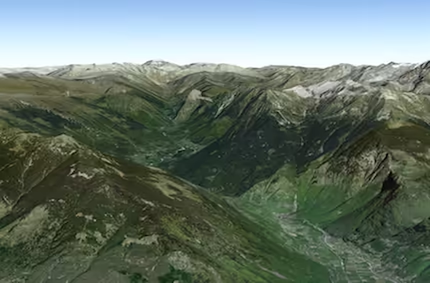
* 
|
|
41
41
|
*
|
|
42
|
+
* Custom elevation layers can supplement the default Terrain 3D elevation layer with higher-resolution
|
|
43
|
+
* elevation data or representing another scenario or point in time for an area of interest.
|
|
44
|
+
* Elevation sources must be published as cached image services.
|
|
45
|
+
*
|
|
42
46
|
* Elevation layers are set in the [Ground.layers](https://developers.arcgis.com/javascript/latest/references/core/Ground/#layers) property of a
|
|
43
47
|
* [map's ground](https://developers.arcgis.com/javascript/latest/references/core/Map/#ground). They should not be added to the
|
|
44
48
|
* map's [operational layers](https://developers.arcgis.com/javascript/latest/references/core/Map/#layers).
|
|
@@ -46,7 +50,7 @@ export interface FetchTileOptions extends AbortOptions {
|
|
|
46
50
|
* ```js
|
|
47
51
|
* let elevLyr = new ElevationLayer({
|
|
48
52
|
* // Custom elevation service
|
|
49
|
-
* url: "https://
|
|
53
|
+
* url: "https://tiles.arcgis.com/tiles/V6ZHFr6zdgNZuVG0/arcgis/rest/services/ELEV__3857__US_Oso__LandslideAfter/ImageServer"
|
|
50
54
|
* });
|
|
51
55
|
* // Add elevation layer to the map's ground.
|
|
52
56
|
* map.ground.layers.add(elevLyr);
|
|
@@ -28,7 +28,7 @@ export interface GeospatialPDFLayerProperties extends LayerProperties, ScaleRang
|
|
|
28
28
|
* The entire document is downloaded before rendering; large or complex PDFs can increase load time and memory usage.
|
|
29
29
|
* The layer derives its [spatial reference](https://developers.arcgis.com/javascript/latest/references/core/layers/GeospatialPDFLayer/#spatialReference) and
|
|
30
30
|
* [extent](https://developers.arcgis.com/javascript/latest/references/core/layers/GeospatialPDFLayer/#fullExtent) from the embedded georeferencing information.
|
|
31
|
-
* The rendered imagery can be reprojected to the spatial reference of the view. In
|
|
31
|
+
* The rendered imagery can be reprojected to the spatial reference of the view. In a scene, it is draped on the ground.
|
|
32
32
|
*
|
|
33
33
|
* Additionally the PDF defines the boundary of the georeferenced map within the page, called a *neatline*.
|
|
34
34
|
* Set [clippedToNeatline](https://developers.arcgis.com/javascript/latest/references/core/layers/GeospatialPDFLayer/#clippedToNeatline) to `true` to hide content outside this boundary, such as page margins, legends, and titles.
|
|
@@ -44,7 +44,7 @@ export interface GeospatialPDFLayerProperties extends LayerProperties, ScaleRang
|
|
|
44
44
|
* >
|
|
45
45
|
* > - Documents that require a password to open are not supported.
|
|
46
46
|
* > - Tile reprojection is limited: grid-based transformations are not supported. As a result, the layer may still display but appear shifted. See the [project operator's known limitations](https://developers.arcgis.com/javascript/latest/references/core/geometry/operators/projectOperator/).
|
|
47
|
-
* > - To decode certain image types from PDF files, GeospatialPDFLayer
|
|
47
|
+
* > - To decode certain image types from PDF files, GeospatialPDFLayer uses WebAssembly features not yet available in Safari. As a result, it uses a slower JavaScript fallback, which impacts the initial load of the layer.
|
|
48
48
|
* > - Not supported by the [Legend](https://developers.arcgis.com/javascript/latest/references/map-components/components/arcgis-legend/).
|
|
49
49
|
*
|
|
50
50
|
* @beta
|
package/layers/ParquetLayer.d.ts
CHANGED
|
@@ -365,7 +365,7 @@ export default class ParquetLayer extends ParquetLayerSuperclass {
|
|
|
365
365
|
/** Describes the layer's supported capabilities. */
|
|
366
366
|
get capabilities(): FeatureLayerCapabilities | null | undefined;
|
|
367
367
|
/**
|
|
368
|
-
* Array of
|
|
368
|
+
* Array of chart items of type WebMapWebChart available on the Parquet layer.
|
|
369
369
|
*
|
|
370
370
|
* @since 5.2
|
|
371
371
|
*/
|
|
@@ -155,7 +155,8 @@ export interface VectorTileLayerEvents extends RefreshableLayerEvents, LayerEven
|
|
|
155
155
|
* and can be restyled for multiple uses. VectorTileLayer delivers styled maps while taking advantage of cached raster map tiles
|
|
156
156
|
* with vector map data.
|
|
157
157
|
*
|
|
158
|
-
*
|
|
158
|
+
* The layer's style defines how vector tile features are drawn. See [Vector tile style support](https://developers.arcgis.com/javascript/latest/vector-tile-style-support/) for
|
|
159
|
+
* supported style layer types, layout and paint properties, expression operators, and limitations.
|
|
159
160
|
* VectorTileLayer [style](https://developers.arcgis.com/javascript/latest/references/core/layers/VectorTileLayer/#currentStyleInfo) information is stored separately from its tiles. This means that one set of vector tiles may be styled in numerous
|
|
160
161
|
* ways without having to generate a new image cache for each style. This helps save space and speeds up the process of creating new map styles.
|
|
161
162
|
*
|
|
@@ -360,6 +361,7 @@ export interface VectorTileLayerEvents extends RefreshableLayerEvents, LayerEven
|
|
|
360
361
|
* > [fill](https://maplibre.org/maplibre-style-spec/layers/#paint-fill-fill-pattern) style layers in the VectorTileLayer style should be a power of two to ensure the best results.
|
|
361
362
|
*
|
|
362
363
|
* @since 4.0
|
|
364
|
+
* @see [Vector tile style support](https://developers.arcgis.com/javascript/latest/vector-tile-style-support/)
|
|
363
365
|
* @see [TileLayer](https://developers.arcgis.com/javascript/latest/references/core/layers/TileLayer/)
|
|
364
366
|
* @see [WebTileLayer](https://developers.arcgis.com/javascript/latest/references/core/layers/WebTileLayer/)
|
|
365
367
|
* @see [Sample - Vector tiles](https://developers.arcgis.com/javascript/latest/sample-code/layers-vectortilelayer/)
|
|
@@ -668,6 +670,7 @@ export default class VectorTileLayer extends VectorTileLayerSuperclass {
|
|
|
668
670
|
* in the VectorTileLayer's [currentStyleInfo.style](https://developers.arcgis.com/javascript/latest/references/core/layers/VectorTileLayer/#currentStyleInfo).
|
|
669
671
|
* @returns [Layout](https://maplibre.org/maplibre-style-spec/layers/#layout-property) JSON object for the specified style layer.
|
|
670
672
|
* @since 4.10
|
|
673
|
+
* @see [Vector tile style support](https://developers.arcgis.com/javascript/latest/vector-tile-style-support/)
|
|
671
674
|
*/
|
|
672
675
|
getLayoutProperties(layerId: string): any;
|
|
673
676
|
/**
|
|
@@ -678,6 +681,7 @@ export default class VectorTileLayer extends VectorTileLayerSuperclass {
|
|
|
678
681
|
* in the VectorTileLayer's [currentStyleInfo.style](https://developers.arcgis.com/javascript/latest/references/core/layers/VectorTileLayer/#currentStyleInfo).
|
|
679
682
|
* @returns [Paint](https://maplibre.org/maplibre-style-spec/layers/#paint) JSON object of the style layer.
|
|
680
683
|
* @since 4.10
|
|
684
|
+
* @see [Vector tile style support](https://developers.arcgis.com/javascript/latest/vector-tile-style-support/)
|
|
681
685
|
*/
|
|
682
686
|
getPaintProperties(layerId: string): any;
|
|
683
687
|
/**
|
|
@@ -688,6 +692,7 @@ export default class VectorTileLayer extends VectorTileLayerSuperclass {
|
|
|
688
692
|
* specified in the VectorTileLayer's [currentStyleInfo.style](https://developers.arcgis.com/javascript/latest/references/core/layers/VectorTileLayer/#currentStyleInfo).
|
|
689
693
|
* @returns The json object representing the [style Layer](https://maplibre.org/maplibre-style-spec/layers).
|
|
690
694
|
* @since 4.18
|
|
695
|
+
* @see [Vector tile style support](https://developers.arcgis.com/javascript/latest/vector-tile-style-support/)
|
|
691
696
|
* @see [Sample - VectorTileLayer - update style layers](https://developers.arcgis.com/javascript/latest/sample-code/layers-vectortilelayer-style/)
|
|
692
697
|
*/
|
|
693
698
|
getStyleLayer(layerId: string): any;
|
|
@@ -720,6 +725,7 @@ export default class VectorTileLayer extends VectorTileLayerSuperclass {
|
|
|
720
725
|
* as specified in the VectorTileLayer's [currentStyleInfo.style](https://developers.arcgis.com/javascript/latest/references/core/layers/VectorTileLayer/#currentStyleInfo).
|
|
721
726
|
* @returns Visibility of style layer. Returns either `"none"` or `"visible"`.
|
|
722
727
|
* @since 4.18
|
|
728
|
+
* @see [Vector tile style support](https://developers.arcgis.com/javascript/latest/vector-tile-style-support/)
|
|
723
729
|
* @see [Sample - VectorTileLayer - update style layers](https://developers.arcgis.com/javascript/latest/sample-code/layers-vectortilelayer-style/)
|
|
724
730
|
* @example
|
|
725
731
|
* // Get the visibility of the grassland style layer in the style.
|
|
@@ -758,6 +764,7 @@ export default class VectorTileLayer extends VectorTileLayerSuperclass {
|
|
|
758
764
|
* in the VectorTileLayer's [currentStyleInfo.style](https://developers.arcgis.com/javascript/latest/references/core/layers/VectorTileLayer/#currentStyleInfo).
|
|
759
765
|
* @param layout - An instance of layout properties to assign to the style layer.
|
|
760
766
|
* @since 4.10
|
|
767
|
+
* @see [Vector tile style support](https://developers.arcgis.com/javascript/latest/vector-tile-style-support/)
|
|
761
768
|
* @example
|
|
762
769
|
* // get the layout properties for the "Admin0 point/large" layer
|
|
763
770
|
* const layoutProperties = vtLayer.getLayoutProperties("Admin0 point/large");
|
|
@@ -781,6 +788,7 @@ export default class VectorTileLayer extends VectorTileLayerSuperclass {
|
|
|
781
788
|
* in the VectorTileLayer's [currentStyleInfo.style](https://developers.arcgis.com/javascript/latest/references/core/layers/VectorTileLayer/#currentStyleInfo).
|
|
782
789
|
* @param painter - An instance of paint properties to assign to the specified style layer.
|
|
783
790
|
* @since 4.10
|
|
791
|
+
* @see [Vector tile style support](https://developers.arcgis.com/javascript/latest/vector-tile-style-support/)
|
|
784
792
|
* @example
|
|
785
793
|
* // get the paint properties for the "marine area/1" layer
|
|
786
794
|
* const paintProperties = vtLayer.getPaintProperties("Marine area/1");
|
|
@@ -887,6 +895,7 @@ export default class VectorTileLayer extends VectorTileLayerSuperclass {
|
|
|
887
895
|
* [getStyleLayer()](https://developers.arcgis.com/javascript/latest/references/core/layers/VectorTileLayer/#getStyleLayer) method.
|
|
888
896
|
* @param index - Index of the style layer in the style. Set this parameter when adding a new style layer or re-ordering a style layer.
|
|
889
897
|
* @since 4.18
|
|
898
|
+
* @see [Vector tile style support](https://developers.arcgis.com/javascript/latest/vector-tile-style-support/)
|
|
890
899
|
* @see [Sample - VectorTileLayer - update style layers](https://developers.arcgis.com/javascript/latest/sample-code/layers-vectortilelayer-style/)
|
|
891
900
|
* @example
|
|
892
901
|
* // change style layer paint and layout properties at once
|