uk_county_locator 0.1.0
This diff represents the content of publicly available package versions that have been released to one of the supported registries. The information contained in this diff is provided for informational purposes only and reflects changes between package versions as they appear in their respective public registries.
- checksums.yaml +7 -0
- data/.rspec +3 -0
- data/.rubocop.yml +19 -0
- data/Appraisals +21 -0
- data/CHANGELOG.md +5 -0
- data/CODE_OF_CONDUCT.md +84 -0
- data/LICENSE +21 -0
- data/LICENSE.txt +21 -0
- data/README.md +168 -0
- data/Rakefile +12 -0
- data/lib/uk_county_locator/aliases/ceremonial_county_aliases.rb +180 -0
- data/lib/uk_county_locator/aliases/current_county_and_unitary_authority_aliases.rb +541 -0
- data/lib/uk_county_locator/aliases/historic_county_aliases.rb +316 -0
- data/lib/uk_county_locator/argument_validator.rb +56 -0
- data/lib/uk_county_locator/locator.rb +63 -0
- data/lib/uk_county_locator/polygon_fetcher.rb +81 -0
- data/lib/uk_county_locator/polygons/ceremonial_county_polygons.rb +85 -0
- data/lib/uk_county_locator/polygons/current_county_and_unitary_authority_polygons.rb +232 -0
- data/lib/uk_county_locator/polygons/historic_county_polygons.rb +103 -0
- data/lib/uk_county_locator/polylines_service.rb +31 -0
- data/lib/uk_county_locator/version.rb +5 -0
- data/lib/uk_county_locator.rb +35 -0
- data/sig/uk_county_locator.rbs +4 -0
- data/uk_county_locator-0.0.2.gem +0 -0
- data/uk_county_locator.gemspec +43 -0
- metadata +132 -0
checksums.yaml
ADDED
|
@@ -0,0 +1,7 @@
|
|
|
1
|
+
---
|
|
2
|
+
SHA256:
|
|
3
|
+
metadata.gz: f80e2a756a051daa471e931e2a6a873d3bcd6cb1cb70982615db766d640e121a
|
|
4
|
+
data.tar.gz: 84f0c67cdc2e61b1a10b0a7df7de88f3d71c6ad304935f2527128c85c9f9e405
|
|
5
|
+
SHA512:
|
|
6
|
+
metadata.gz: b1f68ea7ca094210af2fb2f3802e07226309bf612a6b8dd25d79c55c60baa7ee959bcc4262f794456d19db06173f2aa915c650de1650328b74f2538b082eebfc
|
|
7
|
+
data.tar.gz: 4346bc8f9577b663a8b57a139d11ee8fab609a4c8373ecb8573845437dfd7d448f7f15781ba1efea4e0cc591d757c43b6db467e1937b64a4205882fc50cfc58a
|
data/.rspec
ADDED
data/.rubocop.yml
ADDED
|
@@ -0,0 +1,19 @@
|
|
|
1
|
+
AllCops:
|
|
2
|
+
TargetRubyVersion: 2.6
|
|
3
|
+
|
|
4
|
+
Style/StringLiterals:
|
|
5
|
+
Enabled: true
|
|
6
|
+
EnforcedStyle: single_quotes
|
|
7
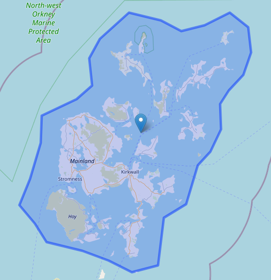
|
+
|
|
8
|
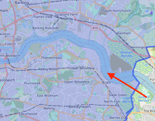
+
Style/StringLiteralsInInterpolation:
|
|
9
|
+
Enabled: true
|
|
10
|
+
EnforcedStyle: double_quotes
|
|
11
|
+
|
|
12
|
+
Layout/LineLength:
|
|
13
|
+
Max: 120
|
|
14
|
+
|
|
15
|
+
Metrics/BlockLength:
|
|
16
|
+
Max: 200
|
|
17
|
+
|
|
18
|
+
Metrics/ModuleLength:
|
|
19
|
+
Max: 200
|
data/Appraisals
ADDED
|
@@ -0,0 +1,21 @@
|
|
|
1
|
+
# frozen_string_literal: true
|
|
2
|
+
|
|
3
|
+
appraise 'rails_5.0' do
|
|
4
|
+
gem 'rails', '~> 5.0'
|
|
5
|
+
end
|
|
6
|
+
|
|
7
|
+
appraise 'rails_5.2' do
|
|
8
|
+
gem 'rails', '~> 5.2'
|
|
9
|
+
end
|
|
10
|
+
|
|
11
|
+
appraise 'rails_6.0' do
|
|
12
|
+
gem 'rails', '~> 6.0'
|
|
13
|
+
end
|
|
14
|
+
|
|
15
|
+
appraise 'rails_6.1' do
|
|
16
|
+
gem 'rails', '~> 6.1'
|
|
17
|
+
end
|
|
18
|
+
|
|
19
|
+
appraise 'rails_7.0' do
|
|
20
|
+
gem 'rails', '~> 7.0'
|
|
21
|
+
end
|
data/CHANGELOG.md
ADDED
data/CODE_OF_CONDUCT.md
ADDED
|
@@ -0,0 +1,84 @@
|
|
|
1
|
+
# Contributor Covenant Code of Conduct
|
|
2
|
+
|
|
3
|
+
## Our Pledge
|
|
4
|
+
|
|
5
|
+
We as members, contributors, and leaders pledge to make participation in our community a harassment-free experience for everyone, regardless of age, body size, visible or invisible disability, ethnicity, sex characteristics, gender identity and expression, level of experience, education, socio-economic status, nationality, personal appearance, race, religion, or sexual identity and orientation.
|
|
6
|
+
|
|
7
|
+
We pledge to act and interact in ways that contribute to an open, welcoming, diverse, inclusive, and healthy community.
|
|
8
|
+
|
|
9
|
+
## Our Standards
|
|
10
|
+
|
|
11
|
+
Examples of behavior that contributes to a positive environment for our community include:
|
|
12
|
+
|
|
13
|
+
* Demonstrating empathy and kindness toward other people
|
|
14
|
+
* Being respectful of differing opinions, viewpoints, and experiences
|
|
15
|
+
* Giving and gracefully accepting constructive feedback
|
|
16
|
+
* Accepting responsibility and apologizing to those affected by our mistakes, and learning from the experience
|
|
17
|
+
* Focusing on what is best not just for us as individuals, but for the overall community
|
|
18
|
+
|
|
19
|
+
Examples of unacceptable behavior include:
|
|
20
|
+
|
|
21
|
+
* The use of sexualized language or imagery, and sexual attention or
|
|
22
|
+
advances of any kind
|
|
23
|
+
* Trolling, insulting or derogatory comments, and personal or political attacks
|
|
24
|
+
* Public or private harassment
|
|
25
|
+
* Publishing others' private information, such as a physical or email
|
|
26
|
+
address, without their explicit permission
|
|
27
|
+
* Other conduct which could reasonably be considered inappropriate in a
|
|
28
|
+
professional setting
|
|
29
|
+
|
|
30
|
+
## Enforcement Responsibilities
|
|
31
|
+
|
|
32
|
+
Community leaders are responsible for clarifying and enforcing our standards of acceptable behavior and will take appropriate and fair corrective action in response to any behavior that they deem inappropriate, threatening, offensive, or harmful.
|
|
33
|
+
|
|
34
|
+
Community leaders have the right and responsibility to remove, edit, or reject comments, commits, code, wiki edits, issues, and other contributions that are not aligned to this Code of Conduct, and will communicate reasons for moderation decisions when appropriate.
|
|
35
|
+
|
|
36
|
+
## Scope
|
|
37
|
+
|
|
38
|
+
This Code of Conduct applies within all community spaces, and also applies when an individual is officially representing the community in public spaces. Examples of representing our community include using an official e-mail address, posting via an official social media account, or acting as an appointed representative at an online or offline event.
|
|
39
|
+
|
|
40
|
+
## Enforcement
|
|
41
|
+
|
|
42
|
+
Instances of abusive, harassing, or otherwise unacceptable behavior may be reported to the community leaders responsible for enforcement at ed@homeflow.co.uk. All complaints will be reviewed and investigated promptly and fairly.
|
|
43
|
+
|
|
44
|
+
All community leaders are obligated to respect the privacy and security of the reporter of any incident.
|
|
45
|
+
|
|
46
|
+
## Enforcement Guidelines
|
|
47
|
+
|
|
48
|
+
Community leaders will follow these Community Impact Guidelines in determining the consequences for any action they deem in violation of this Code of Conduct:
|
|
49
|
+
|
|
50
|
+
### 1. Correction
|
|
51
|
+
|
|
52
|
+
**Community Impact**: Use of inappropriate language or other behavior deemed unprofessional or unwelcome in the community.
|
|
53
|
+
|
|
54
|
+
**Consequence**: A private, written warning from community leaders, providing clarity around the nature of the violation and an explanation of why the behavior was inappropriate. A public apology may be requested.
|
|
55
|
+
|
|
56
|
+
### 2. Warning
|
|
57
|
+
|
|
58
|
+
**Community Impact**: A violation through a single incident or series of actions.
|
|
59
|
+
|
|
60
|
+
**Consequence**: A warning with consequences for continued behavior. No interaction with the people involved, including unsolicited interaction with those enforcing the Code of Conduct, for a specified period of time. This includes avoiding interactions in community spaces as well as external channels like social media. Violating these terms may lead to a temporary or permanent ban.
|
|
61
|
+
|
|
62
|
+
### 3. Temporary Ban
|
|
63
|
+
|
|
64
|
+
**Community Impact**: A serious violation of community standards, including sustained inappropriate behavior.
|
|
65
|
+
|
|
66
|
+
**Consequence**: A temporary ban from any sort of interaction or public communication with the community for a specified period of time. No public or private interaction with the people involved, including unsolicited interaction with those enforcing the Code of Conduct, is allowed during this period. Violating these terms may lead to a permanent ban.
|
|
67
|
+
|
|
68
|
+
### 4. Permanent Ban
|
|
69
|
+
|
|
70
|
+
**Community Impact**: Demonstrating a pattern of violation of community standards, including sustained inappropriate behavior, harassment of an individual, or aggression toward or disparagement of classes of individuals.
|
|
71
|
+
|
|
72
|
+
**Consequence**: A permanent ban from any sort of public interaction within the community.
|
|
73
|
+
|
|
74
|
+
## Attribution
|
|
75
|
+
|
|
76
|
+
This Code of Conduct is adapted from the [Contributor Covenant][homepage], version 2.0,
|
|
77
|
+
available at https://www.contributor-covenant.org/version/2/0/code_of_conduct.html.
|
|
78
|
+
|
|
79
|
+
Community Impact Guidelines were inspired by [Mozilla's code of conduct enforcement ladder](https://github.com/mozilla/diversity).
|
|
80
|
+
|
|
81
|
+
[homepage]: https://www.contributor-covenant.org
|
|
82
|
+
|
|
83
|
+
For answers to common questions about this code of conduct, see the FAQ at
|
|
84
|
+
https://www.contributor-covenant.org/faq. Translations are available at https://www.contributor-covenant.org/translations.
|
data/LICENSE
ADDED
|
@@ -0,0 +1,21 @@
|
|
|
1
|
+
MIT License
|
|
2
|
+
|
|
3
|
+
Copyright (c) 2025 EdBeese
|
|
4
|
+
|
|
5
|
+
Permission is hereby granted, free of charge, to any person obtaining a copy
|
|
6
|
+
of this software and associated documentation files (the "Software"), to deal
|
|
7
|
+
in the Software without restriction, including without limitation the rights
|
|
8
|
+
to use, copy, modify, merge, publish, distribute, sublicense, and/or sell
|
|
9
|
+
copies of the Software, and to permit persons to whom the Software is
|
|
10
|
+
furnished to do so, subject to the following conditions:
|
|
11
|
+
|
|
12
|
+
The above copyright notice and this permission notice shall be included in all
|
|
13
|
+
copies or substantial portions of the Software.
|
|
14
|
+
|
|
15
|
+
THE SOFTWARE IS PROVIDED "AS IS", WITHOUT WARRANTY OF ANY KIND, EXPRESS OR
|
|
16
|
+
IMPLIED, INCLUDING BUT NOT LIMITED TO THE WARRANTIES OF MERCHANTABILITY,
|
|
17
|
+
FITNESS FOR A PARTICULAR PURPOSE AND NONINFRINGEMENT. IN NO EVENT SHALL THE
|
|
18
|
+
AUTHORS OR COPYRIGHT HOLDERS BE LIABLE FOR ANY CLAIM, DAMAGES OR OTHER
|
|
19
|
+
LIABILITY, WHETHER IN AN ACTION OF CONTRACT, TORT OR OTHERWISE, ARISING FROM,
|
|
20
|
+
OUT OF OR IN CONNECTION WITH THE SOFTWARE OR THE USE OR OTHER DEALINGS IN THE
|
|
21
|
+
SOFTWARE.
|
data/LICENSE.txt
ADDED
|
@@ -0,0 +1,21 @@
|
|
|
1
|
+
The MIT License (MIT)
|
|
2
|
+
|
|
3
|
+
Copyright (c) 2025 Edward Beesley
|
|
4
|
+
|
|
5
|
+
Permission is hereby granted, free of charge, to any person obtaining a copy
|
|
6
|
+
of this software and associated documentation files (the "Software"), to deal
|
|
7
|
+
in the Software without restriction, including without limitation the rights
|
|
8
|
+
to use, copy, modify, merge, publish, distribute, sublicense, and/or sell
|
|
9
|
+
copies of the Software, and to permit persons to whom the Software is
|
|
10
|
+
furnished to do so, subject to the following conditions:
|
|
11
|
+
|
|
12
|
+
The above copyright notice and this permission notice shall be included in
|
|
13
|
+
all copies or substantial portions of the Software.
|
|
14
|
+
|
|
15
|
+
THE SOFTWARE IS PROVIDED "AS IS", WITHOUT WARRANTY OF ANY KIND, EXPRESS OR
|
|
16
|
+
IMPLIED, INCLUDING BUT NOT LIMITED TO THE WARRANTIES OF MERCHANTABILITY,
|
|
17
|
+
FITNESS FOR A PARTICULAR PURPOSE AND NONINFRINGEMENT. IN NO EVENT SHALL THE
|
|
18
|
+
AUTHORS OR COPYRIGHT HOLDERS BE LIABLE FOR ANY CLAIM, DAMAGES OR OTHER
|
|
19
|
+
LIABILITY, WHETHER IN AN ACTION OF CONTRACT, TORT OR OTHERWISE, ARISING FROM,
|
|
20
|
+
OUT OF OR IN CONNECTION WITH THE SOFTWARE OR THE USE OR OTHER DEALINGS IN
|
|
21
|
+
THE SOFTWARE.
|
data/README.md
ADDED
|
@@ -0,0 +1,168 @@
|
|
|
1
|
+
# UK County Locator
|
|
2
|
+
|
|
3
|
+
## Overview
|
|
4
|
+
|
|
5
|
+
`UkCountyLocator` is a Ruby gem that determines the county of a given set of coordinates within the UK. It supports multiple county classification types, including ceremonial, historic, and current administrative boundaries. The gem also provides functionality for retrieving county boundary polygons.
|
|
6
|
+
|
|
7
|
+
## Installation
|
|
8
|
+
|
|
9
|
+
Add this line to your application's Gemfile:
|
|
10
|
+
|
|
11
|
+
```ruby
|
|
12
|
+
gem 'uk_county_locator'
|
|
13
|
+
```
|
|
14
|
+
|
|
15
|
+
Then execute:
|
|
16
|
+
|
|
17
|
+
```sh
|
|
18
|
+
bundle install
|
|
19
|
+
```
|
|
20
|
+
|
|
21
|
+
Or install it manually:
|
|
22
|
+
|
|
23
|
+
```sh
|
|
24
|
+
gem install uk_county_locator
|
|
25
|
+
```
|
|
26
|
+
|
|
27
|
+
## Usage
|
|
28
|
+
|
|
29
|
+
### Finding a County by Coordinates
|
|
30
|
+
|
|
31
|
+
```ruby
|
|
32
|
+
require 'uk_county_locator'
|
|
33
|
+
|
|
34
|
+
lat = 51.5074
|
|
35
|
+
lng = -0.1278
|
|
36
|
+
|
|
37
|
+
county = UkCountyLocator.find_county(lat: lat, lng: lng)
|
|
38
|
+
puts county # => "Greater London"
|
|
39
|
+
```
|
|
40
|
+
By default, the gem will return the Ceremonial County of the coordinates.
|
|
41
|
+
|
|
42
|
+
An optional `type` argument, which will accept the following supported county types:
|
|
43
|
+
|
|
44
|
+
- `:current` – Modern administrative counties and Unitary Authorities
|
|
45
|
+
- `:ceremonial` – Traditional ceremonial counties
|
|
46
|
+
- `:historic` – Historic counties
|
|
47
|
+
- `:all` – Includes all available types
|
|
48
|
+
|
|
49
|
+
Assuming the same coordinates above:
|
|
50
|
+
|
|
51
|
+
```ruby
|
|
52
|
+
county_data = UkCountyLocator.find_county(lat: 51.5074, lng: -0.1278, type: :all)
|
|
53
|
+
puts county_data
|
|
54
|
+
# => {:current_county_or_unitary_authority=>"Westminster", :ceremonial_county=>"Greater London", :historic_county=>"Middlesex"}
|
|
55
|
+
```
|
|
56
|
+
### Fetching County Boundaries
|
|
57
|
+
The polygons are stored as encoded strings, using the [Polylines Gem](https://github.com/joshuaclayton/polylines).
|
|
58
|
+
|
|
59
|
+
You can retrieve the encoded string, which can then be decoded using the Polylines Gem.
|
|
60
|
+
|
|
61
|
+
```ruby
|
|
62
|
+
polygon = UkCountyLocator.find_polygon(county: 'Greater London', type: :ceremonial)
|
|
63
|
+
puts polygon # => "iah@mrgyHs@tTkk@zc@jz@h{@kLnr@jo@rWal@}Rrk@za@UjMdhAb_@t|Bjn@`h@|mAzs@kMl\\h..."
|
|
64
|
+
```
|
|
65
|
+
|
|
66
|
+
The gem will support a number of common aliases for county names, in as far as is feasible, including shorthand abbreviations, such as 'Herts', 'Beds' and 'Bucks', as well as Welsh, Irish and Scots Gaelic languages, and more subtle alternative names.
|
|
67
|
+
|
|
68
|
+
#### Fetching the County List
|
|
69
|
+
|
|
70
|
+
It is also possible to fetch the list of counties, per type (alphabetised):
|
|
71
|
+
```ruby
|
|
72
|
+
county_list = UkCountyLocator.county_list(type: :ceremonial)
|
|
73
|
+
puts county_list # => ["Bedfordshire", "Berkshire", "Bristol", "Buckinghamshire", "Cambridgeshire", ...]
|
|
74
|
+
```
|
|
75
|
+
|
|
76
|
+
## County Type Definitions
|
|
77
|
+
There are three sets of county data within the gem. The definitions between the three sets will differ between the four constituent countries of the United Kingdom, but are defined as per these Wikipedia links:
|
|
78
|
+
|
|
79
|
+
### Ceremonial Counties `type: :ceremonial`
|
|
80
|
+
#### England
|
|
81
|
+
[Ceremonial counties of England](https://en.wikipedia.org/wiki/Ceremonial_counties_of_England)
|
|
82
|
+
#### Wales
|
|
83
|
+
[Preserved Counties of Wales](https://en.wikipedia.org/wiki/Preserved_counties_of_Wales)
|
|
84
|
+
#### Scotland
|
|
85
|
+
[Local government areas of Scotland (1975–1996)](https://en.wikipedia.org/wiki/Local_government_areas_of_Scotland_(1975%E2%80%931996))
|
|
86
|
+
#### Northern Ireland
|
|
87
|
+
[Counties of Northern Ireland](https://en.wikipedia.org/wiki/Counties_of_Northern_Ireland)
|
|
88
|
+
### Current Counties & Unitary Authorities `type: :current`
|
|
89
|
+
#### England
|
|
90
|
+
This is a combined map of the different current administrative areas, namely:
|
|
91
|
+
|
|
92
|
+
[County Councils](https://en.wikipedia.org/wiki/List_of_county_councils_in_England)
|
|
93
|
+
|
|
94
|
+
[Unitary Authorities](https://en.wikipedia.org/wiki/Unitary_authorities_of_England)
|
|
95
|
+
|
|
96
|
+
[Metropolitan Boroughs](https://en.wikipedia.org/wiki/Metropolitan_borough)
|
|
97
|
+
|
|
98
|
+
[London Boroughs](https://en.wikipedia.org/wiki/London_boroughs)
|
|
99
|
+
#### Wales
|
|
100
|
+
[Welsh Local Authorities](https://en.wikipedia.org/wiki/Local_government_in_Wales)
|
|
101
|
+
#### Scotland
|
|
102
|
+
[Council Areas of Scotland](https://simple.wikipedia.org/wiki/Council_areas_of_Scotland)
|
|
103
|
+
#### Northern Ireland
|
|
104
|
+
[Local Government Districts of Northern Ireland](https://en.wikipedia.org/wiki/Local_government_in_Northern_Ireland)
|
|
105
|
+
### Historic Counties `type: :historic`
|
|
106
|
+
#### England
|
|
107
|
+
[Historic Counties of England](https://en.wikipedia.org/wiki/Historic_counties_of_England)
|
|
108
|
+
#### Wales
|
|
109
|
+
[Historic Counties of Wales](https://en.wikipedia.org/wiki/Historic_counties_of_Wales)
|
|
110
|
+
#### Scotland
|
|
111
|
+
[Shire Counties of Scotland (1889-1975)](https://en.wikipedia.org/wiki/Shires_of_Scotland#Counties_from_1889_to_1975)
|
|
112
|
+
#### Northern Ireland
|
|
113
|
+
[Counties of Northern Ireland](https://en.wikipedia.org/wiki/Counties_of_Northern_Ireland)
|
|
114
|
+
|
|
115
|
+
## Considerations & Limitations
|
|
116
|
+
### Single Polygon Shapes
|
|
117
|
+
It should be noted that this gem stores the county polygons as encoded strings. In order for these to be encoded, a polygon must be one, continuous shape, rather than a collection of separate, unconnected polygons.
|
|
118
|
+
|
|
119
|
+
To this end, the polygons may cover areas of water that connect separated land masses, such as islands.
|
|
120
|
+
|
|
121
|
+
See image of Orkney Islands polygon:
|
|
122
|
+
|
|
123
|
+
|
|
124
|
+
|
|
125
|
+
|
|
126
|
+
### Rivers, Tributaries and Coastal Lines
|
|
127
|
+
In order to compress the polygon areas, the boundaries that cover coastal lines have been more roughly drawn, with fewer coordinate points. The polygons are continuous where larger rivers and tributaries, where the same county on both sides. This means that coordinates that fall in the river will return the county as a result.
|
|
128
|
+
|
|
129
|
+
For example, coordinates that fall within the river Thames, where Greater London is on both sides of the river, will return 'Greater London' as the ceremonial county.
|
|
130
|
+
|
|
131
|
+
|
|
132
|
+
|
|
133
|
+
This means that the gem would not be an appropriate tool to verify that given coordinates are within the land masses of the UK.
|
|
134
|
+
|
|
135
|
+
## Data Sources
|
|
136
|
+
The data to compile these polygon areas has been taken from a number of sources, including:
|
|
137
|
+
- [OpenStreetMap](https://www.openstreetmap.org/)
|
|
138
|
+
- [Office of National Statistics (ONS)](https://www.ons.gov.uk/aboutus)
|
|
139
|
+
- [UK Ceremonial Counties](https://github.com/evansd/uk-ceremonial-counties/blob/master/uk-ceremonial-counties.geojson)
|
|
140
|
+
- [The Association of British Counties](https://abcounties.com/)
|
|
141
|
+
|
|
142
|
+
## Performance Optimization
|
|
143
|
+
|
|
144
|
+
The gem utilizes the `Parallel` gem to speed up polygon lookups.
|
|
145
|
+
|
|
146
|
+
## Compatibility
|
|
147
|
+
|
|
148
|
+
The gem is tested against multiple versions of Rails using Appraisal, ensuring broad compatibility with different Ruby on Rails applications.
|
|
149
|
+
|
|
150
|
+
## Contributing
|
|
151
|
+
|
|
152
|
+
### Polygon Mapping
|
|
153
|
+
The polygons included within this gem have been generated using the data sources listed above, within an acceptable tollerance of accuracy. However, there may be small errors at the boundaries of polygons.
|
|
154
|
+
|
|
155
|
+
If such an error is noted, pull requests to update the polygons are welcome. Please include details of the area(s) that has been altered within a PR, in order to more efficiently confirm accuracy.
|
|
156
|
+
|
|
157
|
+
### Submitting Fixes and Improvements
|
|
158
|
+
These and all other bug reports and pull requests are welcome on GitHub.
|
|
159
|
+
|
|
160
|
+
1. Fork the repository
|
|
161
|
+
2. Create a new branch (`git checkout -b feature-branch`)
|
|
162
|
+
3. Commit your changes (`git commit -m 'Add new feature'`)
|
|
163
|
+
4. Push to the branch (`git push origin feature-branch`)
|
|
164
|
+
5. Create a new Pull Request
|
|
165
|
+
|
|
166
|
+
## License
|
|
167
|
+
|
|
168
|
+
This project is licensed under the MIT License.
|
data/Rakefile
ADDED
|
@@ -0,0 +1,180 @@
|
|
|
1
|
+
# frozen_string_literal: true
|
|
2
|
+
|
|
3
|
+
module UkCountyLocator
|
|
4
|
+
module Aliases
|
|
5
|
+
module CeremonialCountyAliases
|
|
6
|
+
CEREMONIAL_COUNTY_ALIASES = {
|
|
7
|
+
'London' => 'Greater London',
|
|
8
|
+
'Lon' => 'Greater London',
|
|
9
|
+
'Manchester' => 'Greater Manchester',
|
|
10
|
+
'S Yorkshire' => 'South Yorkshire',
|
|
11
|
+
'S Yorks' => 'South Yorkshire',
|
|
12
|
+
'South Yorks' => 'South Yorkshire',
|
|
13
|
+
'Tyne & Wear' => 'Tyne and Wear',
|
|
14
|
+
'W Midlands' => 'West Midlands',
|
|
15
|
+
'W Yorkshire' => 'West Yorkshire',
|
|
16
|
+
'W Yorks' => 'West Yorkshire',
|
|
17
|
+
'West Yorks' => 'West Yorkshire',
|
|
18
|
+
'N Yorkshire' => 'North Yorkshire',
|
|
19
|
+
'N Yorks' => 'North Yorkshire',
|
|
20
|
+
'North Yorks' => 'North Yorkshire',
|
|
21
|
+
'Durham' => 'County Durham',
|
|
22
|
+
'Co Durham' => 'County Durham',
|
|
23
|
+
'Co Dur' => 'County Durham',
|
|
24
|
+
'Dur' => 'County Durham',
|
|
25
|
+
'Ches' => 'Cheshire',
|
|
26
|
+
'Lancs' => 'Lancashire',
|
|
27
|
+
'East Yorkshire' => 'East Riding of Yorkshire',
|
|
28
|
+
'East Yorks' => 'East Riding of Yorkshire',
|
|
29
|
+
'E Yorkshire' => 'East Riding of Yorkshire',
|
|
30
|
+
'E Yorks' => 'East Riding of Yorkshire',
|
|
31
|
+
'Lincs' => 'Lincolnshire',
|
|
32
|
+
'Derbs' => 'Derbyshire',
|
|
33
|
+
'Rutlandshire' => 'Rutland',
|
|
34
|
+
'Rut' => 'Rutland',
|
|
35
|
+
'Notts' => 'Nottinghamshire',
|
|
36
|
+
'Somersetshire' => 'Somerset',
|
|
37
|
+
'Som' => 'Somerset',
|
|
38
|
+
'Glos' => 'Gloucestershire',
|
|
39
|
+
'Gloucs' => 'Gloucestershire',
|
|
40
|
+
'Dev' => 'Devon',
|
|
41
|
+
'Dor' => 'Dorset',
|
|
42
|
+
'Cambs' => 'Cambridgeshire',
|
|
43
|
+
'Beds' => 'Bedfordshire',
|
|
44
|
+
'Berks' => 'Berkshire',
|
|
45
|
+
'E Sussex' => 'East Sussex',
|
|
46
|
+
'East Sx' => 'East Sussex',
|
|
47
|
+
'E Sx' => 'East Sussex',
|
|
48
|
+
'E Ssx' => 'East Sussex',
|
|
49
|
+
'East Ssx' => 'East Sussex',
|
|
50
|
+
'East Suss' => 'East Sussex',
|
|
51
|
+
'E Suss' => 'East Sussex',
|
|
52
|
+
'Hants' => 'Hampshire',
|
|
53
|
+
'Bucks' => 'Buckinghamshire',
|
|
54
|
+
'Cumberland' => 'Cumbria',
|
|
55
|
+
'Cumb' => 'Cumbria',
|
|
56
|
+
'Herts' => 'Hertfordshire',
|
|
57
|
+
'Leics' => 'Leicestershire',
|
|
58
|
+
'Norf' => 'Norfolk',
|
|
59
|
+
'Northants' => 'Northamptonshire',
|
|
60
|
+
'Oxon' => 'Oxfordshire',
|
|
61
|
+
'Staffs' => 'Staffordshire',
|
|
62
|
+
'Staf' => 'Staffordshire',
|
|
63
|
+
'Suff' => 'Suffolk',
|
|
64
|
+
'Surr' => 'Surrey',
|
|
65
|
+
'Sy' => 'Surrey',
|
|
66
|
+
'Warks' => 'Warwickshire',
|
|
67
|
+
'War' => 'Warwickshire',
|
|
68
|
+
'Warw' => 'Warwickshire',
|
|
69
|
+
'W Sussex' => 'West Sussex',
|
|
70
|
+
'West Sx' => 'West Sussex',
|
|
71
|
+
'W Sx' => 'West Sussex',
|
|
72
|
+
'W Ssx' => 'West Sussex',
|
|
73
|
+
'West Ssx' => 'West Sussex',
|
|
74
|
+
'West Suss' => 'West Sussex',
|
|
75
|
+
'W Suss' => 'West Sussex',
|
|
76
|
+
'Worcs' => 'Worcestershire',
|
|
77
|
+
'Worsts' => 'Worcestershire',
|
|
78
|
+
'Shrops' => 'Shropshire',
|
|
79
|
+
'Salop' => 'Shropshire',
|
|
80
|
+
'Corn' => 'Cornwall',
|
|
81
|
+
'Cornw' => 'Cornwall',
|
|
82
|
+
'Wilts' => 'Wiltshire',
|
|
83
|
+
'Isle Wight' => 'Isle of Wight',
|
|
84
|
+
'Northumb' => 'Northumberland',
|
|
85
|
+
'Northd' => 'Northumberland',
|
|
86
|
+
'Here' => 'Herefordshire',
|
|
87
|
+
'Heref' => 'Herefordshire',
|
|
88
|
+
'Gramp' => 'Grampian',
|
|
89
|
+
"Roinn a' Mhonaidh" => 'Grampian',
|
|
90
|
+
'Strath' => 'Strathclyde',
|
|
91
|
+
'Srath Chluaidh' => 'Strathclyde',
|
|
92
|
+
'Central Scotland' => 'Central (Scotland)',
|
|
93
|
+
'Cent Scotland' => 'Central (Scotland)',
|
|
94
|
+
'C Scotland' => 'Central (Scotland)',
|
|
95
|
+
'Roinn Meadhanach' => 'Central (Scotland)',
|
|
96
|
+
'Dumfries & Galloway' => 'Dumfries and Galloway',
|
|
97
|
+
'Dumfries' => 'Dumfries and Galloway',
|
|
98
|
+
'Galloway' => 'Dumfries and Galloway',
|
|
99
|
+
'Dùn Phris is Gall-Ghaidhealaibh' => 'Dumfries and Galloway',
|
|
100
|
+
'Dun Phris is Gall-Ghaidhealaibh' => 'Dumfries and Galloway',
|
|
101
|
+
'Dùn Phris' => 'Dumfries and Galloway',
|
|
102
|
+
'Dun Phris' => 'Dumfries and Galloway',
|
|
103
|
+
'Gall-Ghaidhealaibh' => 'Dumfries and Galloway',
|
|
104
|
+
'Loth' => 'Lothian',
|
|
105
|
+
'Lodainn' => 'Lothian',
|
|
106
|
+
'Eilean Siar' => 'Eilean Siar (Western Isles)',
|
|
107
|
+
'Western Isles' => 'Eilean Siar (Western Isles)',
|
|
108
|
+
'Outer Hebrides' => 'Eilean Siar (Western Isles)',
|
|
109
|
+
'Na h-Eileanan Siar' => 'Eilean Siar (Western Isles)',
|
|
110
|
+
'Orkney' => 'Orkney Islands',
|
|
111
|
+
'Arcaibh' => 'Orkney Islands',
|
|
112
|
+
'Borders' => 'Scottish Borders',
|
|
113
|
+
'Crìochan na h-Alba' => 'Scottish Borders',
|
|
114
|
+
'Criochan na h-Alba' => 'Scottish Borders',
|
|
115
|
+
'Shetland' => 'Shetland Islands',
|
|
116
|
+
'Zetland' => 'Shetland Islands',
|
|
117
|
+
'Sealtainn' => 'Shetland Islands',
|
|
118
|
+
'W Glamorgan' => 'West Glamorgan',
|
|
119
|
+
'West Glam' => 'West Glamorgan',
|
|
120
|
+
'W Glam' => 'West Glamorgan',
|
|
121
|
+
'Gorllewin Morgannwg' => 'West Glamorgan',
|
|
122
|
+
'M Glamorgan' => 'Mid Glamorgan',
|
|
123
|
+
'Mid Glam' => 'Mid Glamorgan',
|
|
124
|
+
'M Glam' => 'Mid Glamorgan',
|
|
125
|
+
'Morgannwg Ganol' => 'Mid Glamorgan',
|
|
126
|
+
'S Glamorgan' => 'South Glamorgan',
|
|
127
|
+
'South Glam' => 'South Glamorgan',
|
|
128
|
+
'S Glam' => 'South Glamorgan',
|
|
129
|
+
'De Morgannwg' => 'South Glamorgan',
|
|
130
|
+
'Co Tyrone' => 'County Tyrone',
|
|
131
|
+
'Tyrone' => 'County Tyrone',
|
|
132
|
+
'Tir Eoghain' => 'County Tyrone',
|
|
133
|
+
'Tír Eoghain' => 'County Tyrone',
|
|
134
|
+
'Contae Tír Eoghain' => 'County Tyrone',
|
|
135
|
+
'Contae Tir Eoghain' => 'County Tyrone',
|
|
136
|
+
'Coontie Owenslann' => 'County Tyrone',
|
|
137
|
+
'Owenslann' => 'County Tyrone',
|
|
138
|
+
'Co Armagh' => 'County Armagh',
|
|
139
|
+
'Armagh' => 'County Armagh',
|
|
140
|
+
'Contae Ard Mhacha' => 'County Armagh',
|
|
141
|
+
'Ard Mhacha' => 'County Armagh',
|
|
142
|
+
'Coontie Airmagh' => 'County Armagh',
|
|
143
|
+
'Airmagh' => 'County Armagh',
|
|
144
|
+
'Coontie Armagh' => 'County Armagh',
|
|
145
|
+
'Down' => 'County Down',
|
|
146
|
+
'Co Down' => 'County Down',
|
|
147
|
+
'Contae an Dúin' => 'County Down',
|
|
148
|
+
'Contae an Duin' => 'County Down',
|
|
149
|
+
'Dúin' => 'County Down',
|
|
150
|
+
'Duin' => 'County Down',
|
|
151
|
+
'Coontie Doon' => 'County Down',
|
|
152
|
+
'Doon' => 'County Down',
|
|
153
|
+
'Countie Doun' => 'County Down',
|
|
154
|
+
'Doun' => 'County Down',
|
|
155
|
+
'Co Londonderry' => 'County Londonderry',
|
|
156
|
+
'Londonderry' => 'County Londonderry',
|
|
157
|
+
'County Derry' => 'County Londonderry',
|
|
158
|
+
'Derry' => 'County Londonderry',
|
|
159
|
+
'Co Derry' => 'County Londonderry',
|
|
160
|
+
'Contae Dhoire' => 'County Londonderry',
|
|
161
|
+
'Dhoire' => 'County Londonderry',
|
|
162
|
+
'Coontie Lunnonderrie' => 'County Londonderry',
|
|
163
|
+
'Lunnonderrie' => 'County Londonderry',
|
|
164
|
+
'Antrim' => 'County Antrim',
|
|
165
|
+
'Co Antrim' => 'County Antrim',
|
|
166
|
+
'Contae Aontroma' => 'County Antrim',
|
|
167
|
+
'Aontroma' => 'County Antrim',
|
|
168
|
+
'Coontie Antrìm' => 'County Antrim',
|
|
169
|
+
'Fermanagh' => 'County Fermanagh',
|
|
170
|
+
'Co Fermanagh' => 'County Fermanagh',
|
|
171
|
+
'Contae Fhear Manach' => 'County Fermanagh',
|
|
172
|
+
'Fhear Manach' => 'County Fermanagh',
|
|
173
|
+
'Contae Fir Manach' => 'County Fermanagh',
|
|
174
|
+
'Fir Manach' => 'County Fermanagh',
|
|
175
|
+
'Coontie Fermanay' => 'County Fermanagh',
|
|
176
|
+
'Fermanay' => 'County Fermanagh'
|
|
177
|
+
}.freeze
|
|
178
|
+
end
|
|
179
|
+
end
|
|
180
|
+
end
|