ign-lidar-hd 1.1.0__tar.gz
This diff represents the content of publicly available package versions that have been released to one of the supported registries. The information contained in this diff is provided for informational purposes only and reflects changes between package versions as they appear in their respective public registries.
- ign_lidar_hd-1.1.0/LICENSE +21 -0
- ign_lidar_hd-1.1.0/MANIFEST.in +6 -0
- ign_lidar_hd-1.1.0/PKG-INFO +587 -0
- ign_lidar_hd-1.1.0/README.md +543 -0
- ign_lidar_hd-1.1.0/ign_lidar/__init__.py +55 -0
- ign_lidar_hd-1.1.0/ign_lidar/architectural_styles.py +342 -0
- ign_lidar_hd-1.1.0/ign_lidar/classes.py +137 -0
- ign_lidar_hd-1.1.0/ign_lidar/cli.py +872 -0
- ign_lidar_hd-1.1.0/ign_lidar/config.py +327 -0
- ign_lidar_hd-1.1.0/ign_lidar/data/location_replacement_mapping.json +10 -0
- ign_lidar_hd-1.1.0/ign_lidar/downloader.py +639 -0
- ign_lidar_hd-1.1.0/ign_lidar/features.py +936 -0
- ign_lidar_hd-1.1.0/ign_lidar/features_gpu.py +407 -0
- ign_lidar_hd-1.1.0/ign_lidar/metadata.py +351 -0
- ign_lidar_hd-1.1.0/ign_lidar/processor.py +397 -0
- ign_lidar_hd-1.1.0/ign_lidar/qgis_converter.py +240 -0
- ign_lidar_hd-1.1.0/ign_lidar/strategic_locations.py +960 -0
- ign_lidar_hd-1.1.0/ign_lidar/tile_list.py +763 -0
- ign_lidar_hd-1.1.0/ign_lidar/utils.py +189 -0
- ign_lidar_hd-1.1.0/ign_lidar_hd.egg-info/PKG-INFO +587 -0
- ign_lidar_hd-1.1.0/ign_lidar_hd.egg-info/SOURCES.txt +34 -0
- ign_lidar_hd-1.1.0/ign_lidar_hd.egg-info/dependency_links.txt +1 -0
- ign_lidar_hd-1.1.0/ign_lidar_hd.egg-info/entry_points.txt +3 -0
- ign_lidar_hd-1.1.0/ign_lidar_hd.egg-info/requires.txt +16 -0
- ign_lidar_hd-1.1.0/ign_lidar_hd.egg-info/top_level.txt +1 -0
- ign_lidar_hd-1.1.0/pyproject.toml +96 -0
- ign_lidar_hd-1.1.0/requirements.txt +15 -0
- ign_lidar_hd-1.1.0/setup.cfg +4 -0
- ign_lidar_hd-1.1.0/tests/test_building_features.py +309 -0
- ign_lidar_hd-1.1.0/tests/test_chunked_processing.py +59 -0
- ign_lidar_hd-1.1.0/tests/test_cli.py +74 -0
- ign_lidar_hd-1.1.0/tests/test_config_gpu.py +203 -0
- ign_lidar_hd-1.1.0/tests/test_configuration.py +117 -0
- ign_lidar_hd-1.1.0/tests/test_core.py +169 -0
- ign_lidar_hd-1.1.0/tests/test_features.py +102 -0
- ign_lidar_hd-1.1.0/tests/test_new_features.py +162 -0
|
@@ -0,0 +1,21 @@
|
|
|
1
|
+
MIT License
|
|
2
|
+
|
|
3
|
+
Copyright (c) 2025 IGN LiDAR HD Team
|
|
4
|
+
|
|
5
|
+
Permission is hereby granted, free of charge, to any person obtaining a copy
|
|
6
|
+
of this software and associated documentation files (the "Software"), to deal
|
|
7
|
+
in the Software without restriction, including without limitation the rights
|
|
8
|
+
to use, copy, modify, merge, publish, distribute, sublicense, and/or sell
|
|
9
|
+
copies of the Software, and to permit persons to whom the Software is
|
|
10
|
+
furnished to do so, subject to the following conditions:
|
|
11
|
+
|
|
12
|
+
The above copyright notice and this permission notice shall be included in all
|
|
13
|
+
copies or substantial portions of the Software.
|
|
14
|
+
|
|
15
|
+
THE SOFTWARE IS PROVIDED "AS IS", WITHOUT WARRANTY OF ANY KIND, EXPRESS OR
|
|
16
|
+
IMPLIED, INCLUDING BUT NOT LIMITED TO THE WARRANTIES OF MERCHANTABILITY,
|
|
17
|
+
FITNESS FOR A PARTICULAR PURPOSE AND NONINFRINGEMENT. IN NO EVENT SHALL THE
|
|
18
|
+
AUTHORS OR COPYRIGHT HOLDERS BE LIABLE FOR ANY CLAIM, DAMAGES OR OTHER
|
|
19
|
+
LIABILITY, WHETHER IN AN ACTION OF CONTRACT, TORT OR OTHERWISE, ARISING FROM,
|
|
20
|
+
OUT OF OR IN CONNECTION WITH THE SOFTWARE OR THE USE OR OTHER DEALINGS IN THE
|
|
21
|
+
SOFTWARE.
|
|
@@ -0,0 +1,587 @@
|
|
|
1
|
+
Metadata-Version: 2.4
|
|
2
|
+
Name: ign-lidar-hd
|
|
3
|
+
Version: 1.1.0
|
|
4
|
+
Summary: IGN LiDAR HD Dataset Processing Library for Building LOD Classification
|
|
5
|
+
Author-email: Simon Ducournau <simon.ducournau@gmail.com>
|
|
6
|
+
License-Expression: MIT
|
|
7
|
+
Project-URL: Homepage, https://github.com/sducournau/IGN_LIDAR_HD_DATASET
|
|
8
|
+
Project-URL: Repository, https://github.com/sducournau/IGN_LIDAR_HD_DATASET
|
|
9
|
+
Project-URL: Documentation, https://github.com/sducournau/IGN_LIDAR_HD_DATASET#readme
|
|
10
|
+
Project-URL: Issues, https://github.com/sducournau/IGN_LIDAR_HD_DATASET/issues
|
|
11
|
+
Keywords: lidar,ign,machine-learning,gis,building-classification
|
|
12
|
+
Classifier: Development Status :: 4 - Beta
|
|
13
|
+
Classifier: Intended Audience :: Developers
|
|
14
|
+
Classifier: Intended Audience :: Science/Research
|
|
15
|
+
Classifier: Operating System :: OS Independent
|
|
16
|
+
Classifier: Programming Language :: Python :: 3
|
|
17
|
+
Classifier: Programming Language :: Python :: 3.8
|
|
18
|
+
Classifier: Programming Language :: Python :: 3.9
|
|
19
|
+
Classifier: Programming Language :: Python :: 3.10
|
|
20
|
+
Classifier: Programming Language :: Python :: 3.11
|
|
21
|
+
Classifier: Programming Language :: Python :: 3.12
|
|
22
|
+
Classifier: Topic :: Scientific/Engineering
|
|
23
|
+
Classifier: Topic :: Scientific/Engineering :: GIS
|
|
24
|
+
Classifier: Topic :: Scientific/Engineering :: Artificial Intelligence
|
|
25
|
+
Requires-Python: >=3.8
|
|
26
|
+
Description-Content-Type: text/markdown
|
|
27
|
+
License-File: LICENSE
|
|
28
|
+
Requires-Dist: numpy>=1.21.0
|
|
29
|
+
Requires-Dist: laspy>=2.3.0
|
|
30
|
+
Requires-Dist: scikit-learn>=1.0.0
|
|
31
|
+
Requires-Dist: tqdm>=4.60.0
|
|
32
|
+
Requires-Dist: requests>=2.25.0
|
|
33
|
+
Requires-Dist: click>=8.0.0
|
|
34
|
+
Provides-Extra: dev
|
|
35
|
+
Requires-Dist: pytest>=6.0; extra == "dev"
|
|
36
|
+
Requires-Dist: pytest-cov>=4.0; extra == "dev"
|
|
37
|
+
Requires-Dist: black>=22.0; extra == "dev"
|
|
38
|
+
Requires-Dist: flake8>=4.0; extra == "dev"
|
|
39
|
+
Requires-Dist: mypy>=0.910; extra == "dev"
|
|
40
|
+
Requires-Dist: build>=0.7.0; extra == "dev"
|
|
41
|
+
Requires-Dist: twine>=4.0; extra == "dev"
|
|
42
|
+
Requires-Dist: pre-commit>=2.20; extra == "dev"
|
|
43
|
+
Dynamic: license-file
|
|
44
|
+
|
|
45
|
+
<div align="center">
|
|
46
|
+
|
|
47
|
+
# IGN LiDAR HD Processing Library
|
|
48
|
+
|
|
49
|
+
[](https://badge.fury.io/py/ign-lidar-hd)
|
|
50
|
+
[](https://www.python.org/downloads/)
|
|
51
|
+
[](https://opensource.org/licenses/MIT)
|
|
52
|
+
[](tests/)
|
|
53
|
+
|
|
54
|
+
</div>
|
|
55
|
+
<img src="website/static/img/lod3.png" alt="LoD3 Building Model Icon">
|
|
56
|
+
A comprehensive Python library for processing IGN (Institut National de l'Information Géographique et Forestière) LiDAR HD data into machine learning-ready datasets for Building Level of Detail (LOD) classification tasks.
|
|
57
|
+
|
|
58
|
+
## 📺 Video Demo
|
|
59
|
+
|
|
60
|
+
[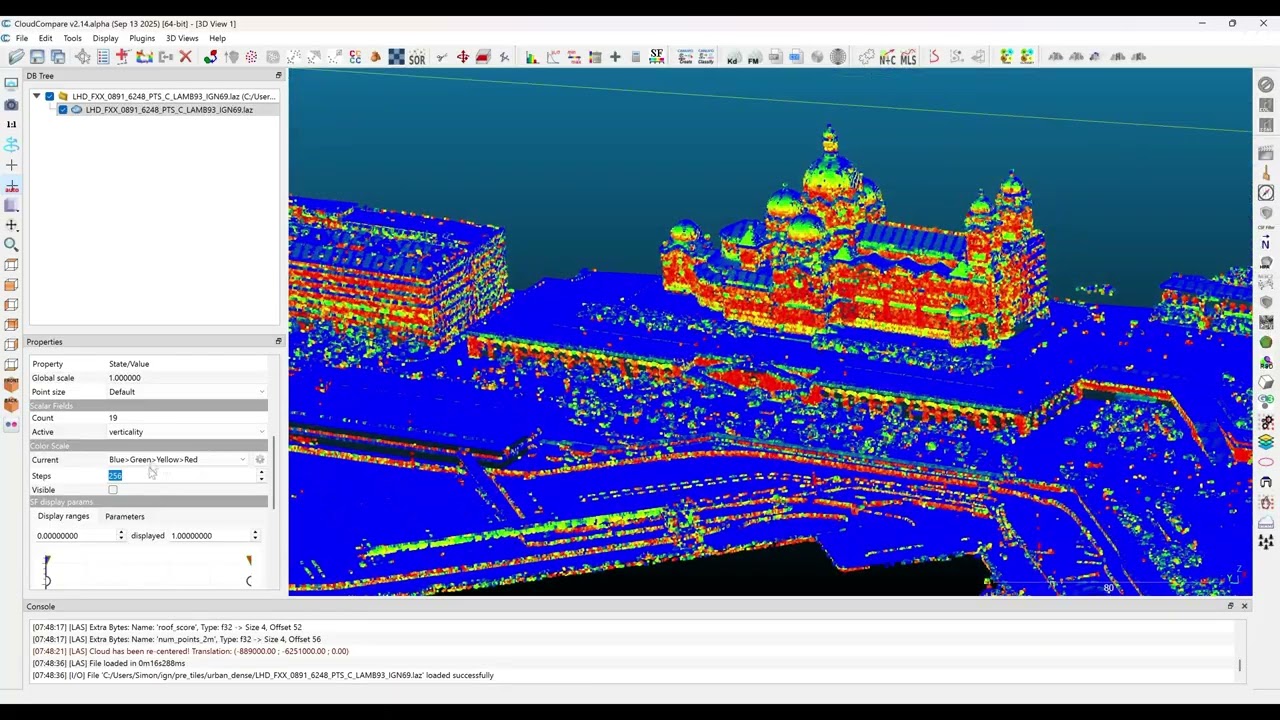](https://youtu.be/ksBWEhkVqQI)
|
|
61
|
+
|
|
62
|
+
**[▶️ Watch the Demo Video](https://youtu.be/ksBWEhkVqQI)** - Learn how to process LiDAR data for machine learning applications
|
|
63
|
+
|
|
64
|
+
## 📊 Project Overview
|
|
65
|
+
|
|
66
|
+
This library transforms raw IGN LiDAR HD point clouds into structured datasets ready for machine learning applications. Built specifically for building classification tasks, it handles the complete pipeline from data acquisition to training-ready patches.
|
|
67
|
+
|
|
68
|
+
### 🔄 **Processing Workflow**
|
|
69
|
+
|
|
70
|
+
```mermaid
|
|
71
|
+
flowchart TD
|
|
72
|
+
A[IGN LiDAR HD Data] --> B[Download Tiles]
|
|
73
|
+
B --> C[Enrich with Features]
|
|
74
|
+
C --> D[Create Training Patches]
|
|
75
|
+
D --> E[ML-Ready Dataset]
|
|
76
|
+
|
|
77
|
+
B --> B1[Smart Skip Detection]
|
|
78
|
+
C --> C1[GPU/CPU Processing]
|
|
79
|
+
C --> C2[Geometric Features]
|
|
80
|
+
D --> D1[Data Augmentation]
|
|
81
|
+
D --> D2[LOD Classification]
|
|
82
|
+
|
|
83
|
+
style A fill:#e1f5fe
|
|
84
|
+
style E fill:#e8f5e8
|
|
85
|
+
style B1 fill:#fff3e0
|
|
86
|
+
style C1 fill:#fff3e0
|
|
87
|
+
style D1 fill:#fff3e0
|
|
88
|
+
```
|
|
89
|
+
|
|
90
|
+
**📈 Project Stats:**
|
|
91
|
+
|
|
92
|
+
- 🏗️ **14 core modules** - Comprehensive processing toolkit
|
|
93
|
+
- 📝 **10 example scripts** - From basic usage to advanced workflows
|
|
94
|
+
- 🧪 **Comprehensive test suite** - Ensuring reliability and performance
|
|
95
|
+
- 🌍 **50+ curated tiles** - Covering diverse French territories
|
|
96
|
+
- ⚡ **GPU & CPU support** - Flexible computation backends
|
|
97
|
+
- 🔄 **Smart resumability** - Never reprocess existing data
|
|
98
|
+
|
|
99
|
+
---
|
|
100
|
+
|
|
101
|
+
## 🚀 Quick Start
|
|
102
|
+
|
|
103
|
+
### Installation
|
|
104
|
+
|
|
105
|
+
```bash
|
|
106
|
+
pip install ign-lidar-hd
|
|
107
|
+
```
|
|
108
|
+
|
|
109
|
+
### Basic Usage
|
|
110
|
+
|
|
111
|
+
```python
|
|
112
|
+
from ign_lidar import LiDARProcessor
|
|
113
|
+
|
|
114
|
+
# Initialize processor
|
|
115
|
+
processor = LiDARProcessor(lod_level="LOD2")
|
|
116
|
+
|
|
117
|
+
# Process a single tile
|
|
118
|
+
patches = processor.process_tile("data.laz", "output/")
|
|
119
|
+
|
|
120
|
+
# Process multiple files
|
|
121
|
+
patches = processor.process_directory("data/", "output/", num_workers=4)
|
|
122
|
+
```
|
|
123
|
+
|
|
124
|
+
### Command Line Interface
|
|
125
|
+
|
|
126
|
+
```bash
|
|
127
|
+
# Download tiles
|
|
128
|
+
ign-lidar-process download --bbox -2.0,47.0,-1.0,48.0 --output tiles/ --max-tiles 10
|
|
129
|
+
|
|
130
|
+
# Enrich LAZ files with geometric features
|
|
131
|
+
ign-lidar-process enrich --input-dir tiles/ --output enriched/ --num-workers 4
|
|
132
|
+
|
|
133
|
+
# Enrich with GPU acceleration
|
|
134
|
+
ign-lidar-process enrich --input-dir tiles/ --output enriched/ --use-gpu
|
|
135
|
+
|
|
136
|
+
# Create training patches
|
|
137
|
+
ign-lidar-process process --input-dir enriched/ --output patches/ --lod-level LOD2
|
|
138
|
+
|
|
139
|
+
# Full pipeline example
|
|
140
|
+
ign-lidar-process download --bbox -2.0,47.0,-1.0,48.0 --output tiles/
|
|
141
|
+
ign-lidar-process enrich --input-dir tiles/ --output enriched/ --num-workers 4
|
|
142
|
+
ign-lidar-process process --input-dir enriched/ --output patches/ --lod-level LOD2
|
|
143
|
+
```
|
|
144
|
+
|
|
145
|
+
## 📋 Key Features
|
|
146
|
+
|
|
147
|
+
### 🏗️ **Core Processing Capabilities**
|
|
148
|
+
|
|
149
|
+
- **LiDAR-only processing**: Pure geometric analysis without RGB dependencies
|
|
150
|
+
- **Multi-level classification**: Support for LOD2 (15 classes) and LOD3 (30+ classes)
|
|
151
|
+
- **Rich feature extraction**: Surface normals, curvature, planarity, verticality, local density
|
|
152
|
+
- **Architectural style inference**: Automatic building style classification
|
|
153
|
+
- **Patch-based processing**: Configurable 150m × 150m patches with overlap control
|
|
154
|
+
|
|
155
|
+
### ⚡ **Performance & Optimization**
|
|
156
|
+
|
|
157
|
+
- **GPU acceleration**: CUDA-enabled feature computation for faster processing
|
|
158
|
+
- **Parallel processing**: Multi-worker support with automatic CPU core detection
|
|
159
|
+
- **Memory optimization**: Chunked processing for large datasets
|
|
160
|
+
- **Smart skip detection**: ⏭️ Automatically skip existing files and resume interrupted workflows
|
|
161
|
+
- **Batch operations**: Process hundreds of tiles efficiently
|
|
162
|
+
|
|
163
|
+
### 🔧 **Workflow Automation**
|
|
164
|
+
|
|
165
|
+
- **Integrated downloader**: IGN WFS tile discovery and batch downloading
|
|
166
|
+
- **Format flexibility**: Choose between LAZ 1.4 (full features) or QGIS-compatible output
|
|
167
|
+
- **Data augmentation**: Rotation, jitter, scaling, and dropout for ML training
|
|
168
|
+
- **Unified CLI**: Single `ign-lidar-process` command with intuitive subcommands
|
|
169
|
+
- **Idempotent operations**: Safe to restart - never reprocesses existing data
|
|
170
|
+
|
|
171
|
+
### 🌍 **Geographic Intelligence**
|
|
172
|
+
|
|
173
|
+
- **Strategic locations**: Pre-configured urban, coastal, and rural area processing
|
|
174
|
+
- **Bounding box filtering**: Spatial subsetting for targeted analysis
|
|
175
|
+
- **Coordinate system handling**: Automatic Lambert93 to WGS84 transformations
|
|
176
|
+
- **Tile management**: Curated collection of 50+ test tiles across France
|
|
177
|
+
|
|
178
|
+
## 🏗️ Library Architecture
|
|
179
|
+
|
|
180
|
+
### 🎯 **Component Architecture**
|
|
181
|
+
|
|
182
|
+
```mermaid
|
|
183
|
+
graph TB
|
|
184
|
+
subgraph "Core Processing"
|
|
185
|
+
P[processor.py<br/>🔧 Main Engine]
|
|
186
|
+
F[features.py<br/>⚡ Feature Extraction]
|
|
187
|
+
GPU[features_gpu.py<br/>🖥️ GPU Acceleration]
|
|
188
|
+
end
|
|
189
|
+
|
|
190
|
+
subgraph "Data Management"
|
|
191
|
+
D[downloader.py<br/>📥 IGN WFS Integration]
|
|
192
|
+
TL[tile_list.py<br/>📂 Tile Management]
|
|
193
|
+
SL[strategic_locations.py<br/>�️ Geographic Zones]
|
|
194
|
+
MD[metadata.py<br/>📊 Dataset Metadata]
|
|
195
|
+
end
|
|
196
|
+
|
|
197
|
+
subgraph "Classification & Styles"
|
|
198
|
+
C[classes.py<br/>🏢 LOD2/LOD3 Schemas]
|
|
199
|
+
AS[architectural_styles.py<br/>🎨 Style Inference]
|
|
200
|
+
end
|
|
201
|
+
|
|
202
|
+
subgraph "Integration & Config"
|
|
203
|
+
CLI[cli.py<br/>🖱️ Command Interface]
|
|
204
|
+
CFG[config.py<br/>⚙️ Configuration]
|
|
205
|
+
QGIS[qgis_converter.py<br/>🔄 QGIS Compatibility]
|
|
206
|
+
U[utils.py<br/>🛠️ Core Utilities]
|
|
207
|
+
end
|
|
208
|
+
|
|
209
|
+
CLI --> P
|
|
210
|
+
CLI --> D
|
|
211
|
+
P --> F
|
|
212
|
+
P --> GPU
|
|
213
|
+
P --> C
|
|
214
|
+
F --> AS
|
|
215
|
+
D --> TL
|
|
216
|
+
D --> SL
|
|
217
|
+
P --> MD
|
|
218
|
+
|
|
219
|
+
style P fill:#e3f2fd
|
|
220
|
+
style F fill:#e8f5e8
|
|
221
|
+
style D fill:#fff3e0
|
|
222
|
+
style CLI fill:#f3e5f5
|
|
223
|
+
```
|
|
224
|
+
|
|
225
|
+
### 📋 **Module Responsibilities**
|
|
226
|
+
|
|
227
|
+
| Module | Purpose | Key Features |
|
|
228
|
+
| ---------------------------- | ---------------------- | ---------------------------------------------------------- |
|
|
229
|
+
| 🔧 `processor.py` | Main processing engine | Patch creation, LOD classification, workflow orchestration |
|
|
230
|
+
| 📥 `downloader.py` | IGN WFS integration | Tile discovery, batch download, smart skip detection |
|
|
231
|
+
| ⚡ `features.py` | Feature extraction | Normals, curvature, geometric properties |
|
|
232
|
+
| �️ `features_gpu.py` | GPU acceleration | CUDA-optimized feature computation |
|
|
233
|
+
| 🏢 `classes.py` | Classification schemas | LOD2/LOD3 building taxonomies |
|
|
234
|
+
| 🎨 `architectural_styles.py` | Style inference | Building architecture classification |
|
|
235
|
+
|
|
236
|
+
### 🔄 **Example Workflows**
|
|
237
|
+
|
|
238
|
+
```text
|
|
239
|
+
examples/
|
|
240
|
+
├── 🚀 basic_usage.py # Getting started
|
|
241
|
+
├── 🏙️ example_urban_simple.py # Urban processing
|
|
242
|
+
├── ⚡ parallel_processing_example.py # Performance
|
|
243
|
+
├── 🔄 full_workflow_example.py # End-to-end pipeline
|
|
244
|
+
├── 🎨 multistyle_processing.py # Architecture analysis
|
|
245
|
+
├── 🧠 pytorch_dataloader.py # ML integration
|
|
246
|
+
└── workflows/ # Production pipelines
|
|
247
|
+
```
|
|
248
|
+
|
|
249
|
+
## ⚙️ CLI Commands
|
|
250
|
+
|
|
251
|
+
The package provides a unified `ign-lidar-process` command with three subcommands:
|
|
252
|
+
|
|
253
|
+
### 🔗 **CLI Workflow Chain**
|
|
254
|
+
|
|
255
|
+
```mermaid
|
|
256
|
+
sequenceDiagram
|
|
257
|
+
participant User
|
|
258
|
+
participant CLI as ign-lidar-process
|
|
259
|
+
participant D as Downloader
|
|
260
|
+
participant E as Enricher
|
|
261
|
+
participant P as Processor
|
|
262
|
+
|
|
263
|
+
User->>CLI: download --bbox ...
|
|
264
|
+
CLI->>D: Initialize downloader
|
|
265
|
+
D->>D: Fetch available tiles
|
|
266
|
+
D->>D: Smart skip check
|
|
267
|
+
D-->>CLI: Downloaded tiles
|
|
268
|
+
CLI-->>User: ✓ Tiles ready
|
|
269
|
+
|
|
270
|
+
User->>CLI: enrich --input-dir ...
|
|
271
|
+
CLI->>E: Initialize enricher
|
|
272
|
+
E->>E: Compute geometric features
|
|
273
|
+
E->>E: GPU/CPU processing
|
|
274
|
+
E-->>CLI: Enriched LAZ files
|
|
275
|
+
CLI-->>User: ✓ Features computed
|
|
276
|
+
|
|
277
|
+
User->>CLI: process --input-dir ...
|
|
278
|
+
CLI->>P: Initialize processor
|
|
279
|
+
P->>P: Create training patches
|
|
280
|
+
P->>P: Apply augmentations
|
|
281
|
+
P-->>CLI: ML-ready dataset
|
|
282
|
+
CLI-->>User: ✓ Dataset ready
|
|
283
|
+
```
|
|
284
|
+
|
|
285
|
+
### Download Command
|
|
286
|
+
|
|
287
|
+
Download LiDAR tiles from IGN:
|
|
288
|
+
|
|
289
|
+
```bash
|
|
290
|
+
ign-lidar-process download \
|
|
291
|
+
--bbox lon_min,lat_min,lon_max,lat_max \
|
|
292
|
+
--output tiles/ \
|
|
293
|
+
--max-tiles 50
|
|
294
|
+
```
|
|
295
|
+
|
|
296
|
+
### Enrich Command
|
|
297
|
+
|
|
298
|
+
Enrich LAZ files with geometric features:
|
|
299
|
+
|
|
300
|
+
```bash
|
|
301
|
+
# CPU version (automatically skips existing enriched files)
|
|
302
|
+
ign-lidar-process enrich \
|
|
303
|
+
--input-dir tiles/ \
|
|
304
|
+
--output enriched/ \
|
|
305
|
+
--num-workers 4 \
|
|
306
|
+
--k-neighbors 10
|
|
307
|
+
|
|
308
|
+
# Force re-enrichment (ignore existing files)
|
|
309
|
+
ign-lidar-process enrich \
|
|
310
|
+
--input-dir tiles/ \
|
|
311
|
+
--output enriched/ \
|
|
312
|
+
--force
|
|
313
|
+
|
|
314
|
+
# GPU version (requires CUDA)
|
|
315
|
+
ign-lidar-process enrich \
|
|
316
|
+
--input-dir tiles/ \
|
|
317
|
+
--output enriched/ \
|
|
318
|
+
--use-gpu
|
|
319
|
+
```
|
|
320
|
+
|
|
321
|
+
> 💡 **Smart Skip**: By default, the enrich command skips files that have already been enriched, making it safe to resume interrupted operations.
|
|
322
|
+
|
|
323
|
+
### Process Command
|
|
324
|
+
|
|
325
|
+
Create training patches from enriched LAZ files:
|
|
326
|
+
|
|
327
|
+
```bash
|
|
328
|
+
# Automatically skips tiles with existing patches
|
|
329
|
+
ign-lidar-process process \
|
|
330
|
+
--input-dir enriched/ \
|
|
331
|
+
--output patches/ \
|
|
332
|
+
--lod-level LOD2 \
|
|
333
|
+
--patch-size 150.0 \
|
|
334
|
+
--num-workers 4 \
|
|
335
|
+
--num-augmentations 3
|
|
336
|
+
|
|
337
|
+
# Force reprocessing (ignore existing patches)
|
|
338
|
+
ign-lidar-process process \
|
|
339
|
+
--input-dir enriched/ \
|
|
340
|
+
--output patches/ \
|
|
341
|
+
--force
|
|
342
|
+
```
|
|
343
|
+
|
|
344
|
+
> 💡 **Smart Skip**: The process command automatically detects existing patches and skips reprocessing, allowing you to resume interrupted batch jobs.
|
|
345
|
+
|
|
346
|
+
## 🔧 Configuration
|
|
347
|
+
|
|
348
|
+
### LOD Levels
|
|
349
|
+
|
|
350
|
+
- **LOD2**: Simplified building models (15 classes)
|
|
351
|
+
- **LOD3**: Detailed building models (30 classes)
|
|
352
|
+
|
|
353
|
+
### Processing Options
|
|
354
|
+
|
|
355
|
+
```python
|
|
356
|
+
processor = LiDARProcessor(
|
|
357
|
+
lod_level="LOD2", # LOD2 or LOD3
|
|
358
|
+
augment=True, # Enable augmentation
|
|
359
|
+
num_augmentations=3, # Augmentations per patch
|
|
360
|
+
patch_size=150.0, # Patch size in meters
|
|
361
|
+
patch_overlap=0.1, # 10% overlap
|
|
362
|
+
bbox=[xmin, ymin, xmax, ymax] # Spatial filter
|
|
363
|
+
)
|
|
364
|
+
```
|
|
365
|
+
|
|
366
|
+
## 📊 Output Format
|
|
367
|
+
|
|
368
|
+
### 📁 **Data Structure Overview**
|
|
369
|
+
|
|
370
|
+
```mermaid
|
|
371
|
+
graph TB
|
|
372
|
+
subgraph "Raw Input"
|
|
373
|
+
LAZ[LAZ Point Cloud<br/>XYZ + Intensity<br/>Classification]
|
|
374
|
+
end
|
|
375
|
+
|
|
376
|
+
subgraph "Enriched Data"
|
|
377
|
+
ELAZ[Enhanced LAZ<br/>+ 30 Features<br/>+ Building Labels]
|
|
378
|
+
end
|
|
379
|
+
|
|
380
|
+
subgraph "ML Dataset"
|
|
381
|
+
NPZ[NPZ Patches<br/>16K points each<br/>Ready for Training]
|
|
382
|
+
end
|
|
383
|
+
|
|
384
|
+
subgraph "NPZ Contents"
|
|
385
|
+
COORD[Coordinates<br/>X, Y, Z]
|
|
386
|
+
GEOM[Geometric Features<br/>Normals, Curvature]
|
|
387
|
+
SEMANTIC[Semantic Features<br/>Planarity, Verticality]
|
|
388
|
+
META[Metadata<br/>Intensity, Return#]
|
|
389
|
+
LABELS[Building Labels<br/>LOD2/LOD3 Classes]
|
|
390
|
+
end
|
|
391
|
+
|
|
392
|
+
LAZ --> ELAZ
|
|
393
|
+
ELAZ --> NPZ
|
|
394
|
+
NPZ --> COORD
|
|
395
|
+
NPZ --> GEOM
|
|
396
|
+
NPZ --> SEMANTIC
|
|
397
|
+
NPZ --> META
|
|
398
|
+
NPZ --> LABELS
|
|
399
|
+
|
|
400
|
+
style LAZ fill:#ffebee
|
|
401
|
+
style ELAZ fill:#e3f2fd
|
|
402
|
+
style NPZ fill:#e8f5e8
|
|
403
|
+
```
|
|
404
|
+
|
|
405
|
+
### 🔢 **NPZ File Structure**
|
|
406
|
+
|
|
407
|
+
Each patch is saved as an NPZ file containing:
|
|
408
|
+
|
|
409
|
+
```python
|
|
410
|
+
{
|
|
411
|
+
'points': np.ndarray, # [N, 3] XYZ coordinates
|
|
412
|
+
'normals': np.ndarray, # [N, 3] surface normals
|
|
413
|
+
'curvature': np.ndarray, # [N] principal curvature
|
|
414
|
+
'intensity': np.ndarray, # [N] normalized intensity
|
|
415
|
+
'return_number': np.ndarray, # [N] return number
|
|
416
|
+
'height': np.ndarray, # [N] height above ground
|
|
417
|
+
'planarity': np.ndarray, # [N] planarity measure
|
|
418
|
+
'verticality': np.ndarray, # [N] verticality measure
|
|
419
|
+
'horizontality': np.ndarray, # [N] horizontality measure
|
|
420
|
+
'density': np.ndarray, # [N] local point density
|
|
421
|
+
'labels': np.ndarray, # [N] building class labels
|
|
422
|
+
}
|
|
423
|
+
```
|
|
424
|
+
|
|
425
|
+
### 📏 **Data Dimensions**
|
|
426
|
+
|
|
427
|
+
| Component | Shape | Data Type | Description |
|
|
428
|
+
| ---------- | ------- | --------- | -------------------------- |
|
|
429
|
+
| `points` | [N, 3] | `float32` | 3D coordinates (X, Y, Z) |
|
|
430
|
+
| `normals` | [N, 3] | `float32` | Surface normal vectors |
|
|
431
|
+
| `features` | [N, 27] | `float32` | Geometric feature matrix |
|
|
432
|
+
| `labels` | [N] | `uint8` | Building component classes |
|
|
433
|
+
| `metadata` | [4] | `object` | Patch info (bbox, tile_id) |
|
|
434
|
+
|
|
435
|
+
> **📦 Typical patch**: 16,384 points, ~2.5MB compressed, ~8MB in memory
|
|
436
|
+
|
|
437
|
+
## 🌍 Batch Download
|
|
438
|
+
|
|
439
|
+
```python
|
|
440
|
+
from ign_lidar import IGNLiDARDownloader
|
|
441
|
+
|
|
442
|
+
# Initialize downloader
|
|
443
|
+
downloader = IGNLiDARDownloader("downloads/")
|
|
444
|
+
|
|
445
|
+
# Download tiles by bounding box (WGS84)
|
|
446
|
+
tiles = downloader.download_by_bbox(
|
|
447
|
+
bbox=(-2.0, 47.0, -1.0, 48.0), # West France
|
|
448
|
+
max_tiles=10
|
|
449
|
+
)
|
|
450
|
+
|
|
451
|
+
# Download specific tiles
|
|
452
|
+
tile_names = ["LHD_FXX_0186_6834_PTS_C_LAMB93_IGN69"]
|
|
453
|
+
downloader.download_tiles(tile_names)
|
|
454
|
+
```
|
|
455
|
+
|
|
456
|
+
## 📝 Examples
|
|
457
|
+
|
|
458
|
+
### Urban Processing
|
|
459
|
+
|
|
460
|
+
```python
|
|
461
|
+
# High-detail urban processing
|
|
462
|
+
processor = LiDARProcessor(lod_level="LOD3", num_augmentations=5)
|
|
463
|
+
patches = processor.process_tile("urban_area.laz", "output/urban/")
|
|
464
|
+
```
|
|
465
|
+
|
|
466
|
+
### Rural Processing
|
|
467
|
+
|
|
468
|
+
```python
|
|
469
|
+
# Simplified rural processing
|
|
470
|
+
processor = LiDARProcessor(lod_level="LOD2", num_augmentations=2)
|
|
471
|
+
patches = processor.process_tile("rural_area.laz", "output/rural/")
|
|
472
|
+
```
|
|
473
|
+
|
|
474
|
+
### Batch Processing
|
|
475
|
+
|
|
476
|
+
```python
|
|
477
|
+
from ign_lidar import WORKING_TILES, get_tiles_by_environment
|
|
478
|
+
|
|
479
|
+
# Get coastal tiles
|
|
480
|
+
coastal_tiles = get_tiles_by_environment("coastal")
|
|
481
|
+
|
|
482
|
+
# Process all coastal areas
|
|
483
|
+
for tile_info in coastal_tiles:
|
|
484
|
+
patches = processor.process_tile(
|
|
485
|
+
f"data/{tile_info['tile_name']}.laz",
|
|
486
|
+
f"output/coastal/{tile_info['tile_name']}/"
|
|
487
|
+
)
|
|
488
|
+
```
|
|
489
|
+
|
|
490
|
+
## 🛠️ Development
|
|
491
|
+
|
|
492
|
+
### Setup Development Environment
|
|
493
|
+
|
|
494
|
+
```bash
|
|
495
|
+
git clone https://github.com/your-username/ign-lidar-hd-downloader
|
|
496
|
+
cd ign-lidar-hd-downloader
|
|
497
|
+
pip install -e ".[dev]"
|
|
498
|
+
```
|
|
499
|
+
|
|
500
|
+
### Run Tests
|
|
501
|
+
|
|
502
|
+
```bash
|
|
503
|
+
pytest tests/
|
|
504
|
+
```
|
|
505
|
+
|
|
506
|
+
### Code Formatting
|
|
507
|
+
|
|
508
|
+
```bash
|
|
509
|
+
black ign_lidar/
|
|
510
|
+
flake8 ign_lidar/
|
|
511
|
+
```
|
|
512
|
+
|
|
513
|
+
## 📚 Documentation & Resources
|
|
514
|
+
|
|
515
|
+
### 📖 **Complete Documentation Hub**
|
|
516
|
+
|
|
517
|
+
For comprehensive documentation, see the **[Documentation Hub](docs/README.md)**:
|
|
518
|
+
|
|
519
|
+
- **[📖 User Guides](docs/guides/)** - Quick start guides, QGIS integration, troubleshooting
|
|
520
|
+
- **[⚡ Features](docs/features/)** - Smart skip detection, format preferences, workflow optimization
|
|
521
|
+
- **[🔧 Technical Reference](docs/reference/)** - Memory optimization, performance tuning
|
|
522
|
+
- **[📦 Archive](docs/archive/)** - Bug fixes history, release notes, migration guides
|
|
523
|
+
|
|
524
|
+
### 🚀 **Essential Quick Links**
|
|
525
|
+
|
|
526
|
+
- **[🎯 Quick Reference Card](QUICK_REFERENCE.md)** - Fast reference for all commands
|
|
527
|
+
- **[⚡ Smart Skip Features](docs/features/SMART_SKIP_SUMMARY.md)** - Resume workflows efficiently
|
|
528
|
+
- **[🗺️ QGIS Integration](docs/guides/QUICK_START_QGIS.md)** - GIS compatibility guide
|
|
529
|
+
- **[⚙️ Memory Optimization](docs/reference/MEMORY_OPTIMIZATION.md)** - Performance tuning
|
|
530
|
+
- **[📋 Output Formats](docs/features/OUTPUT_FORMAT_PREFERENCES.md)** - LAZ 1.4 vs QGIS formats
|
|
531
|
+
|
|
532
|
+
### 💡 **Examples & Workflows**
|
|
533
|
+
|
|
534
|
+
- **[Basic Usage](examples/basic_usage.py)** - Simple processing examples
|
|
535
|
+
- **[Urban Processing](examples/example_urban_simple.py)** - City-specific workflows
|
|
536
|
+
- **[Parallel Processing](examples/parallel_processing_example.py)** - Multi-worker optimization
|
|
537
|
+
- **[Full Workflow](examples/full_workflow_example.py)** - End-to-end pipeline
|
|
538
|
+
- **[PyTorch Integration](examples/pytorch_dataloader.py)** - ML training setup
|
|
539
|
+
|
|
540
|
+
### 🚀 Coming Soon: Interactive Documentation
|
|
541
|
+
|
|
542
|
+
We're working on a comprehensive [Docusaurus documentation site](DOCUSAURUS_PLAN.md) that will include:
|
|
543
|
+
|
|
544
|
+
- 🌐 Multi-language support (English & French)
|
|
545
|
+
- 🔍 Full-text search
|
|
546
|
+
- 📱 Mobile-responsive design
|
|
547
|
+
- 📖 Interactive tutorials
|
|
548
|
+
- 🔗 Auto-generated API reference
|
|
549
|
+
- 💡 Live code examples
|
|
550
|
+
|
|
551
|
+
See the [Docusaurus Plan](DOCUSAURUS_PLAN.md) for details.
|
|
552
|
+
|
|
553
|
+
## 📚 API Reference
|
|
554
|
+
|
|
555
|
+
### Core Classes
|
|
556
|
+
|
|
557
|
+
- **`LiDARProcessor`**: Main processing engine
|
|
558
|
+
- **`IGNLiDARDownloader`**: Batch download functionality
|
|
559
|
+
- **`LOD2_CLASSES`**, **`LOD3_CLASSES`**: Classification taxonomies
|
|
560
|
+
|
|
561
|
+
### Utility Functions
|
|
562
|
+
|
|
563
|
+
- **`compute_normals()`**: Surface normal computation
|
|
564
|
+
- **`compute_curvature()`**: Principal curvature calculation
|
|
565
|
+
- **`extract_geometric_features()`**: Comprehensive feature extraction
|
|
566
|
+
- **`get_tiles_by_environment()`**: Filter tiles by environment type
|
|
567
|
+
|
|
568
|
+
## 🔗 Requirements
|
|
569
|
+
|
|
570
|
+
- Python 3.8+
|
|
571
|
+
- NumPy >= 1.21.0
|
|
572
|
+
- laspy >= 2.3.0
|
|
573
|
+
- scikit-learn >= 1.0.0
|
|
574
|
+
- tqdm >= 4.60.0
|
|
575
|
+
- requests >= 2.25.0
|
|
576
|
+
|
|
577
|
+
## 📄 License
|
|
578
|
+
|
|
579
|
+
MIT License - see [LICENSE](LICENSE) file for details.
|
|
580
|
+
|
|
581
|
+
## 🤝 Contributing
|
|
582
|
+
|
|
583
|
+
Contributions are welcome! Please feel free to submit a Pull Request.
|
|
584
|
+
|
|
585
|
+
## 📧 Support
|
|
586
|
+
|
|
587
|
+
For issues and questions, please use the [GitHub Issues](https://github.com/your-username/ign-lidar-hd-downloader/issues) page.
|