us_geo 1.0.3 → 2.0.0
This diff represents the content of publicly available package versions that have been released to one of the supported registries. The information contained in this diff is provided for informational purposes only and reflects changes between package versions as they appear in their respective public registries.
- checksums.yaml +4 -4
- data/CHANGELOG.md +82 -0
- data/MIT_LICENSE.txt +21 -0
- data/README.md +77 -60
- data/UPDATING_TO_VERSION_2.md +172 -0
- data/VERSION +1 -0
- data/db/migrate/20190221054200_create_regions.rb +4 -2
- data/db/migrate/20190221054300_create_divisions.rb +4 -2
- data/db/migrate/20190221054400_create_states.rb +4 -2
- data/db/migrate/20190221054500_create_combined_statistical_areas.rb +4 -2
- data/db/migrate/20190221054600_create_core_based_statistical_areas.rb +4 -2
- data/db/migrate/20190221054650_create_metropolitan_divisions.rb +4 -2
- data/db/migrate/20190221054700_create_counties.rb +4 -3
- data/db/migrate/20190221054800_create_zctas.rb +4 -2
- data/db/migrate/20190221054900_create_zcta_counties.rb +4 -2
- data/db/migrate/20190221055000_create_urban_areas.rb +4 -2
- data/db/migrate/20190221055100_create_urban_area_counties.rb +4 -4
- data/db/migrate/20190221055200_create_zcta_urban_areas.rb +4 -4
- data/db/migrate/20190221060000_create_places.rb +4 -2
- data/db/migrate/20190221061000_create_place_counties.rb +4 -2
- data/db/migrate/20190221062000_create_zcta_places.rb +4 -4
- data/db/migrate/20190221063000_create_county_subdivisions.rb +4 -2
- data/db/migrate/20220722000000_allow_null_zcta_counties_demographics.rb +23 -0
- data/db/migrate/20220722000200_allow_null_zcta_places_demographics.rb +23 -0
- data/db/migrate/20230414000000_add_zcta_primary_place.rb +13 -0
- data/db/migrate/20230414000200_add_demographics_to_regions.rb +28 -0
- data/db/migrate/20230414000300_add_demographics_to_divisions.rb +28 -0
- data/db/migrate/20230414000400_add_demographics_to_states.rb +28 -0
- data/db/migrate/20230414000700_add_short_name_to_core_based_statistical_areas.rb +22 -0
- data/db/migrate/20230414000750_add_short_name_to_combined_statistical_areas.rb +22 -0
- data/db/migrate/20230414000800_create_zcta_mappings.rb +18 -0
- data/db/migrate/20230417000100_create_zcta_county_subdivisions.rb +22 -0
- data/db/migrate/20230417000200_add_unique_name_index_to_county_subdivisions.rb +26 -0
- data/db/migrate/20230417000250_add_zcta_primary_county_subdivision.rb +13 -0
- data/db/migrate/20230417000300_create_urban_area_county_subdivisions.rb +23 -0
- data/db/migrate/20230417000400_allow_null_urban_area_counties_demographics.rb +23 -0
- data/db/migrate/20230417000500_allow_null_zcta_urban_areas_demographics.rb +23 -0
- data/db/migrate/20230417000600_add_additional_time_zone_name_to_counties.rb +13 -0
- data/db/schema.rb +303 -0
- data/explorer_app/.gitattributes +7 -0
- data/explorer_app/.gitignore +34 -0
- data/explorer_app/Gemfile +38 -0
- data/explorer_app/Rakefile +6 -0
- data/explorer_app/app/assets/images/.keep +0 -0
- data/explorer_app/app/assets/stylesheets/application.css +1 -0
- data/explorer_app/app/controllers/application_controller.rb +64 -0
- data/explorer_app/app/controllers/combined_statistical_areas_controller.rb +12 -0
- data/explorer_app/app/controllers/concerns/.keep +0 -0
- data/explorer_app/app/controllers/core_based_statistical_areas_controller.rb +36 -0
- data/explorer_app/app/controllers/counties_controller.rb +22 -0
- data/explorer_app/app/controllers/county_subdivisions_controller.rb +23 -0
- data/explorer_app/app/controllers/divisions_controller.rb +27 -0
- data/explorer_app/app/controllers/home_controller.rb +6 -0
- data/explorer_app/app/controllers/metropolitan_divisions_controller.rb +27 -0
- data/explorer_app/app/controllers/places_controller.rb +23 -0
- data/explorer_app/app/controllers/regions_controller.rb +13 -0
- data/explorer_app/app/controllers/states_controller.rb +25 -0
- data/explorer_app/app/controllers/urban_areas_controller.rb +24 -0
- data/explorer_app/app/controllers/zctas_controller.rb +23 -0
- data/explorer_app/app/helpers/application_helper.rb +137 -0
- data/explorer_app/app/models/application_record.rb +3 -0
- data/explorer_app/app/models/concerns/.keep +0 -0
- data/explorer_app/app/views/combined_statistical_areas/_table.html.erb +18 -0
- data/explorer_app/app/views/combined_statistical_areas/index.html.erb +7 -0
- data/explorer_app/app/views/combined_statistical_areas/show.html.erb +52 -0
- data/explorer_app/app/views/core_based_statistical_areas/_table.html.erb +32 -0
- data/explorer_app/app/views/core_based_statistical_areas/index.html.erb +19 -0
- data/explorer_app/app/views/core_based_statistical_areas/show.html.erb +60 -0
- data/explorer_app/app/views/counties/_table.html.erb +64 -0
- data/explorer_app/app/views/counties/show.html.erb +96 -0
- data/explorer_app/app/views/county_subdivisions/_table.html.erb +48 -0
- data/explorer_app/app/views/county_subdivisions/show.html.erb +84 -0
- data/explorer_app/app/views/divisions/_table.html.erb +24 -0
- data/explorer_app/app/views/divisions/index.html.erb +3 -0
- data/explorer_app/app/views/divisions/show.html.erb +3 -0
- data/explorer_app/app/views/home/index.html.erb +23 -0
- data/explorer_app/app/views/layouts/application.html.erb +34 -0
- data/explorer_app/app/views/metropolitan_divisions/_table.html.erb +42 -0
- data/explorer_app/app/views/metropolitan_divisions/index.html.erb +8 -0
- data/explorer_app/app/views/metropolitan_divisions/show.html.erb +46 -0
- data/explorer_app/app/views/places/_table.html.erb +47 -0
- data/explorer_app/app/views/places/show.html.erb +92 -0
- data/explorer_app/app/views/regions/_table.html.erb +18 -0
- data/explorer_app/app/views/regions/index.html.erb +7 -0
- data/explorer_app/app/views/regions/show.html.erb +3 -0
- data/explorer_app/app/views/shared/_breadcrumbs.html.erb +13 -0
- data/explorer_app/app/views/shared/_demographics_cells.html.erb +5 -0
- data/explorer_app/app/views/shared/_demographics_headers.html.erb +5 -0
- data/explorer_app/app/views/states/_table.html.erb +31 -0
- data/explorer_app/app/views/states/index.html.erb +7 -0
- data/explorer_app/app/views/states/show.html.erb +54 -0
- data/explorer_app/app/views/urban_areas/_table.html.erb +45 -0
- data/explorer_app/app/views/urban_areas/index.html.erb +19 -0
- data/explorer_app/app/views/urban_areas/show.html.erb +68 -0
- data/explorer_app/app/views/zctas/_table.html.erb +60 -0
- data/explorer_app/app/views/zctas/show.html.erb +104 -0
- data/explorer_app/bin/bundle +109 -0
- data/explorer_app/bin/rails +4 -0
- data/explorer_app/bin/rake +4 -0
- data/explorer_app/bin/setup +33 -0
- data/explorer_app/config/application.rb +37 -0
- data/explorer_app/config/boot.rb +3 -0
- data/explorer_app/config/database.yml +13 -0
- data/explorer_app/config/environment.rb +5 -0
- data/explorer_app/config/environments/development.rb +59 -0
- data/explorer_app/config/initializers/filter_parameter_logging.rb +8 -0
- data/explorer_app/config/locales/en.yml +2 -0
- data/explorer_app/config/puma.rb +43 -0
- data/explorer_app/config/routes.rb +56 -0
- data/explorer_app/config.ru +6 -0
- data/explorer_app/db/seeds.rb +7 -0
- data/explorer_app/lib/assets/.keep +0 -0
- data/explorer_app/lib/tasks/.keep +0 -0
- data/explorer_app/log/.keep +0 -0
- data/explorer_app/public/404.html +67 -0
- data/explorer_app/public/422.html +67 -0
- data/explorer_app/public/500.html +66 -0
- data/explorer_app/public/apple-touch-icon-precomposed.png +0 -0
- data/explorer_app/public/apple-touch-icon.png +0 -0
- data/explorer_app/public/favicon.ico +0 -0
- data/explorer_app/public/robots.txt +1 -0
- data/explorer_app/tmp/.keep +0 -0
- data/explorer_app/tmp/pids/.keep +0 -0
- data/lib/tasks/us_geo/us_geo.rake +44 -3
- data/lib/us_geo/area.rb +44 -0
- data/lib/us_geo/base_record.rb +22 -16
- data/lib/us_geo/combined_statistical_area.rb +18 -8
- data/lib/us_geo/core_based_statistical_area.rb +24 -12
- data/lib/us_geo/county.rb +67 -16
- data/lib/us_geo/county_subdivision.rb +43 -7
- data/lib/us_geo/division.rb +17 -7
- data/lib/us_geo/metropolitan_area.rb +1 -5
- data/lib/us_geo/metropolitan_division.rb +17 -9
- data/lib/us_geo/micropolitan_area.rb +1 -5
- data/lib/us_geo/place.rb +61 -11
- data/lib/us_geo/place_county.rb +1 -4
- data/lib/us_geo/population.rb +26 -0
- data/lib/us_geo/region.rb +18 -8
- data/lib/us_geo/state.rb +32 -11
- data/lib/us_geo/urban_area.rb +46 -16
- data/lib/us_geo/urban_area_county.rb +4 -21
- data/lib/us_geo/urban_area_county_subdivision.rb +51 -0
- data/lib/us_geo/urban_cluster.rb +1 -5
- data/lib/us_geo/urbanized_area.rb +1 -5
- data/lib/us_geo/version.rb +1 -1
- data/lib/us_geo/zcta.rb +90 -13
- data/lib/us_geo/zcta_county.rb +5 -22
- data/lib/us_geo/zcta_county_subdivision.rb +51 -0
- data/lib/us_geo/zcta_mapping.rb +35 -0
- data/lib/us_geo/zcta_place.rb +5 -12
- data/lib/us_geo/zcta_urban_area.rb +3 -20
- data/lib/us_geo.rb +34 -31
- data/us_geo.gemspec +36 -0
- metadata +125 -129
- data/Gemfile +0 -5
- data/Gemfile.lock +0 -75
- data/Rakefile +0 -18
- data/db/migrate/20190221054490_create_designated_market_areas.rb +0 -16
- data/lib/us_geo/demographics.rb +0 -25
- data/lib/us_geo/designated_market_area.rb +0 -30
- data/spec/spec_helper.rb +0 -22
- data/spec/us_geo/base_record_spec.rb +0 -67
- data/spec/us_geo/combined_statistical_area_spec.rb +0 -33
- data/spec/us_geo/core_based_statistical_area_spec.rb +0 -56
- data/spec/us_geo/county_spec.rb +0 -131
- data/spec/us_geo/county_subdivision_spec.rb +0 -37
- data/spec/us_geo/demographics_spec.rb +0 -19
- data/spec/us_geo/designated_market_area_spec.rb +0 -29
- data/spec/us_geo/division_spec.rb +0 -37
- data/spec/us_geo/metropolitan_division_spec.rb +0 -41
- data/spec/us_geo/place_county_spec.rb +0 -39
- data/spec/us_geo/place_spec.rb +0 -71
- data/spec/us_geo/region_spec.rb +0 -36
- data/spec/us_geo/state_spec.rb +0 -70
- data/spec/us_geo/urban_area_county_spec.rb +0 -82
- data/spec/us_geo/urban_area_spec.rb +0 -98
- data/spec/us_geo/zcta_county_spec.rb +0 -82
- data/spec/us_geo/zcta_place_spec.rb +0 -82
- data/spec/us_geo/zcta_spec.rb +0 -99
- data/spec/us_geo/zcta_urban_area_spec.rb +0 -82
checksums.yaml
CHANGED
|
@@ -1,7 +1,7 @@
|
|
|
1
1
|
---
|
|
2
2
|
SHA256:
|
|
3
|
-
metadata.gz:
|
|
4
|
-
data.tar.gz:
|
|
3
|
+
metadata.gz: 2dfc74542cb99a60205494e209802884c849a4bd0f05f06fc1bb644d7ad27e62
|
|
4
|
+
data.tar.gz: 39e6ca65501f0244529893ba3eb4b1a3ff07aa836649f8beeaad70ed380e9b69
|
|
5
5
|
SHA512:
|
|
6
|
-
metadata.gz:
|
|
7
|
-
data.tar.gz:
|
|
6
|
+
metadata.gz: 4fdf470e2c5773e4ca335b89dfdd79ba67205160bc894118be7898ccddaabd5a81fecc448ce2ab8fc775823935b6df60f493fdfd4647f90c1d35e35254a53f10
|
|
7
|
+
data.tar.gz: 7424c521ab4736f001392640240de3ba1255656babacbd2eef45b036a260060ac57e73e0bd147f3cc4f5811dcbd79da2a0a13009dbcfeea8f27196972d1bfac4
|
data/CHANGELOG.md
ADDED
|
@@ -0,0 +1,82 @@
|
|
|
1
|
+
# Changelog
|
|
2
|
+
All notable changes to this project will be documented in this file.
|
|
3
|
+
|
|
4
|
+
The format is based on [Keep a Changelog](https://keepachangelog.com/en/1.0.0/),
|
|
5
|
+
and this project adheres to [Semantic Versioning](https://semver.org/spec/v2.0.0.html).
|
|
6
|
+
|
|
7
|
+
## 2.0.0
|
|
8
|
+
|
|
9
|
+
### Changed
|
|
10
|
+
|
|
11
|
+
- Data is now based on the 2020 U.S. Census
|
|
12
|
+
* ZCTAs have been both added and removed
|
|
13
|
+
* Places have been both added and removed
|
|
14
|
+
* Some counties and subdivisions have been renamed
|
|
15
|
+
* A number of smaller urban areas have been removed
|
|
16
|
+
* Former U.S. territories (Micronesia, Palau, and Marshall Islands) have been removed
|
|
17
|
+
|
|
18
|
+
- Population and housing unit numbers are now based on the 2021 [American Community Survey Five Year Estimates](https://www.census.gov/programs-surveys/acs).
|
|
19
|
+
|
|
20
|
+
- Entities that are legally independent of other county subdivisions are included as both county subdivisions and places.
|
|
21
|
+
|
|
22
|
+
- Areas in the CSV data files are now in square miles instead of square meters to match the data after it is imported into a database.
|
|
23
|
+
|
|
24
|
+
### Added
|
|
25
|
+
|
|
26
|
+
- ZCTA's are now associated with a primary place defined as the place with the most overlapping land area with the ZCTA.
|
|
27
|
+
|
|
28
|
+
- ZCTAS's are now associated with county subdivisions and have a primary county subdivision which is the one with the moste land area overlapping the ZCTA.
|
|
29
|
+
|
|
30
|
+
- 2010 ZCTAs can still be used to lookup the active ZCTA through the ZCTAMapping model.
|
|
31
|
+
|
|
32
|
+
- Core Based Statistical Areas and Combined Statistical Areas now have a short name which is the name of just the largest city in the area. This makes them a little easier to refer to by name.
|
|
33
|
+
|
|
34
|
+
- All Geographic entity models now have land area, water area, population, and housing units columns.
|
|
35
|
+
|
|
36
|
+
- Urban Areas are now associated with county subdivisions.
|
|
37
|
+
|
|
38
|
+
- Counties can now have multiple time zones. You can still call `time_zone` to get a single time zone for a county, but it is more accurate to call `time_zones` instead. There are only a handful of counties that span time zones and none are heavily populated (the largest is Coconino County, AZ with 145K people).
|
|
39
|
+
|
|
40
|
+
### Removed
|
|
41
|
+
|
|
42
|
+
- The Designated Market Area model has been removed. This data was a crude mapping from counties to DMA's and was not accurate since it didn't respect the actual borders. The table and foreign keys to it will not be removed if they are already in your database. See the [updating guide](UPDATING_TO_VERSION_2.md) form more details.
|
|
43
|
+
|
|
44
|
+
- Population and housing unit data has been removed from the overlap models used to join entities (i.e. `ZctaCounty`, `ZctaPlace`, `PlaceCounty`). This information is no longer available directly from the Census relationship files. Only the overlapping land and water area is now available.
|
|
45
|
+
|
|
46
|
+
- The `USGeo::Demographics` module has been removed. The functionality is split into `USGeo::Area` and `USGeo::Population`.
|
|
47
|
+
|
|
48
|
+
- Dropped support for ActiveRecord 5.0 and 5.1
|
|
49
|
+
|
|
50
|
+
- Dropped support for Ruby 2.5.
|
|
51
|
+
|
|
52
|
+
### Fixed
|
|
53
|
+
|
|
54
|
+
- Fixed arithmetic for converting area from square miles to kilometers.
|
|
55
|
+
|
|
56
|
+
## 1.0.3
|
|
57
|
+
|
|
58
|
+
### Added
|
|
59
|
+
|
|
60
|
+
- Make dependencies compatible with Rails 6
|
|
61
|
+
|
|
62
|
+
## 1.0.2
|
|
63
|
+
|
|
64
|
+
### Added
|
|
65
|
+
|
|
66
|
+
- Add missing metropolitan division codes to counties
|
|
67
|
+
|
|
68
|
+
### Changed
|
|
69
|
+
|
|
70
|
+
- Fix short name logic to be more conservative in how it shortens names
|
|
71
|
+
|
|
72
|
+
## 1.0.1
|
|
73
|
+
|
|
74
|
+
### Changed
|
|
75
|
+
|
|
76
|
+
- Fix logic to enforce place short name limit on databases that don't have character limits.
|
|
77
|
+
|
|
78
|
+
## 1.0.0
|
|
79
|
+
|
|
80
|
+
### Added
|
|
81
|
+
|
|
82
|
+
- Initial release
|
data/MIT_LICENSE.txt
ADDED
|
@@ -0,0 +1,21 @@
|
|
|
1
|
+
The MIT License (MIT)
|
|
2
|
+
|
|
3
|
+
Copyright (c) 2019 Brian Durand
|
|
4
|
+
|
|
5
|
+
Permission is hereby granted, free of charge, to any person obtaining a copy
|
|
6
|
+
of this software and associated documentation files (the "Software"), to deal
|
|
7
|
+
in the Software without restriction, including without limitation the rights
|
|
8
|
+
to use, copy, modify, merge, publish, distribute, sublicense, and/or sell
|
|
9
|
+
copies of the Software, and to permit persons to whom the Software is
|
|
10
|
+
furnished to do so, subject to the following conditions:
|
|
11
|
+
|
|
12
|
+
The above copyright notice and this permission notice shall be included in
|
|
13
|
+
all copies or substantial portions of the Software.
|
|
14
|
+
|
|
15
|
+
THE SOFTWARE IS PROVIDED "AS IS", WITHOUT WARRANTY OF ANY KIND, EXPRESS OR
|
|
16
|
+
IMPLIED, INCLUDING BUT NOT LIMITED TO THE WARRANTIES OF MERCHANTABILITY,
|
|
17
|
+
FITNESS FOR A PARTICULAR PURPOSE AND NONINFRINGEMENT. IN NO EVENT SHALL THE
|
|
18
|
+
AUTHORS OR COPYRIGHT HOLDERS BE LIABLE FOR ANY CLAIM, DAMAGES OR OTHER
|
|
19
|
+
LIABILITY, WHETHER IN AN ACTION OF CONTRACT, TORT OR OTHERWISE, ARISING FROM,
|
|
20
|
+
OUT OF OR IN CONNECTION WITH THE SOFTWARE OR THE USE OR OTHER DEALINGS IN
|
|
21
|
+
THE SOFTWARE.
|
data/README.md
CHANGED
|
@@ -1,50 +1,57 @@
|
|
|
1
1
|
# USGeo
|
|
2
2
|
|
|
3
3
|
[](https://travis-ci.com/bdurand/us_geo)
|
|
4
|
-
[](https://github.com/testdouble/standard)
|
|
5
5
|
|
|
6
|
-
This gem provides a variety of U.S. geographic data ActiveRecord models. It is designed to provide a normalized way to access the data from a relational database. This is by no means a complete set of data.
|
|
6
|
+
This gem provides a variety of U.S. geographic data ActiveRecord models. It is designed to provide a normalized way to access the data from a relational database. This is by no means a complete set of data.
|
|
7
|
+
|
|
8
|
+
The primary purpose it was built for is to provide a way to match ZIP codes to higher level geographic entities.
|
|
9
|
+
|
|
10
|
+
You can use the data from this gem in non-Ruby probjects. The data is provided as [CSV files](./data/2020_dist/) which you can import into any database or spreadsheet. You can see the database structure in the [schema.rb file](./db/schema.rb).
|
|
7
11
|
|
|
8
12
|
## Entities
|
|
9
13
|
|
|
10
|
-
All of the entities
|
|
14
|
+
All of the entities are defined by the U.S. Census Bureau. For more details.
|
|
11
15
|
|
|
12
16
|
https://www2.census.gov/geo/pdfs/reference/geodiagram.pdf
|
|
13
17
|
https://www2.census.gov/geo/pdfs/reference/GARM/Ch2GARM.pdf
|
|
14
18
|
|
|
15
|
-
|
|
19
|
+
[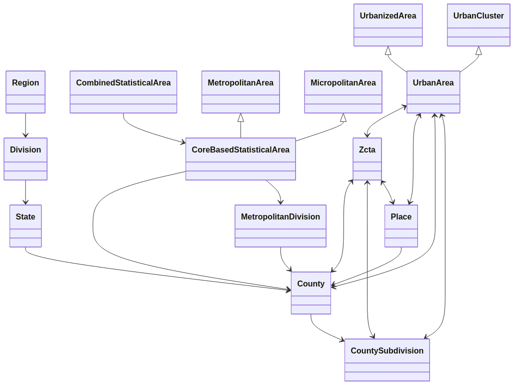](https://mermaid.live/edit#pako:eNqFVEFuwjAQ_IrlM_kAQpVa0iNS1YhLlcvGXqglx0a2U4lS_t7EDlESlpALZmZ2s5qd-MKFlcjXXGjwPldwdFCXhrVPRNgnHpU1pRljufpR_g4tAgRkU2xrGxPOFFY0lSTbfIkAU-RDg8B5D4dv4FF2L1U-KAH61SHMVXWlzBPRDoOzJ6tVAEOwSiyxo1ralL2rqMIIq1-UD6itbnxAd2M6T9gmy14GQyl0YulU0FvYgfHIxr0SnhYdiXzS5fYvUnHJCU_7ng-VzuzBVEkzt5xt_rJsYaexZraIpzW3ccgI9PMtvfARS1hHxYAwZqHfUpCGCKVVpu-DIEY7njHjMUiK2NEkocnsUZYHRR_UOwFf8RpdDUq2d8ulKyh5-MYaS75ujxIP0OhQ8tJcW2lzkm2W3qUK1vH1AbTHFYcm2OJsxAAkVX9HDSjGql1_i3U_13-31qQd)
|
|
20
|
+
|
|
21
|
+
All entities in the system are keyed using external identifiers.
|
|
16
22
|
|
|
17
|
-
* The various `geoid` columns reference the id used by the U.S. Census Bureau.
|
|
23
|
+
* The various `geoid` columns reference the id used by the [U.S. Census Bureau](https://www.census.gov/programs-surveys/geography/guidance/geo-identifiers.html).
|
|
18
24
|
|
|
19
|
-
* The `gnis_id` columns are the official ID's assigned by the U.S. Board on Geographic Names
|
|
25
|
+
* The `gnis_id` columns are the official ID's assigned by the [U.S. Board on Geographic Names](https://geonames.usgs.gov).
|
|
20
26
|
|
|
21
27
|
|
|
22
28
|
There are no foreign key constraints defined on the tables. This is intentional so that you can only import as much data as you need if you don't need the whole set.
|
|
23
29
|
|
|
24
|
-
The data set currently contains
|
|
30
|
+
The data set currently contains:
|
|
25
31
|
|
|
26
32
|
* 4 Regions
|
|
27
33
|
* 9 Divisions
|
|
28
|
-
*
|
|
29
|
-
* 210 Designated Market Areas
|
|
34
|
+
* 56 States and Territories
|
|
30
35
|
* 175 Combined Statistical Areas
|
|
31
|
-
*
|
|
36
|
+
* 939 Core Based Statistical Areas
|
|
32
37
|
* 31 Metropolitan Divisions
|
|
33
|
-
*
|
|
34
|
-
*
|
|
35
|
-
*
|
|
36
|
-
*
|
|
37
|
-
*
|
|
38
|
+
* 3234 Counties or equivalents
|
|
39
|
+
* 35,657 County Subdivisions
|
|
40
|
+
* 2,313 Urban Areas
|
|
41
|
+
* 31,846 Places
|
|
42
|
+
* 33,791 ZIP Code Tabulation Areas
|
|
38
43
|
|
|
39
|
-
|
|
44
|
+
The population, number of housing units, land area, and water area is supplied for all geographic entities.
|
|
40
45
|
|
|
41
|
-
|
|
42
|
-
* 17389 ZCTA to Urban Area
|
|
43
|
-
* 49843 ZCTA to Place
|
|
44
|
-
* 4945 Urban Area to County
|
|
45
|
-
* 31492 Place to County
|
|
46
|
+
In addition, there entity to entity mapping tables containing information about how entities overlap with each other:
|
|
46
47
|
|
|
47
|
-
|
|
48
|
+
* 46,953 ZCTA to County
|
|
49
|
+
* 109,549 ZCTA to County Subdivision
|
|
50
|
+
* 14,455 ZCTA to Urban Area
|
|
51
|
+
* 53,131 ZCTA to Place
|
|
52
|
+
* 33,276 Place to County
|
|
53
|
+
* 33,09 County to Urban Area
|
|
54
|
+
* 11,755 County Subdivison to Urban Area
|
|
48
55
|
|
|
49
56
|
### Region
|
|
50
57
|
|
|
@@ -56,29 +63,23 @@ A grouping of states within a region.
|
|
|
56
63
|
|
|
57
64
|
### State
|
|
58
65
|
|
|
59
|
-
Includes both states
|
|
66
|
+
Includes both states, territories, and the District of Columbia.
|
|
60
67
|
|
|
61
|
-
###
|
|
68
|
+
### Core Based Statistical Area (CBSA)
|
|
62
69
|
|
|
63
|
-
|
|
70
|
+
A grouping of counties around an urban core defined by commuting patterns. CBSA's are split into metropolitan (population > 50,000) and micropolitan areas. Counties within a CBSA are either identified as being core or outlyer counties. Not all counties belong to a CBSA.
|
|
64
71
|
|
|
65
72
|
### Combined Statistical Areas
|
|
66
73
|
|
|
67
74
|
Groupings of adjacent CBSA's with regional ties to each other.
|
|
68
75
|
|
|
69
|
-
### Core Based Statistical Area (CBSA)
|
|
70
|
-
|
|
71
|
-
A grouping of counties around an urban core defined by commuting patterns. CBSA's are split into metropolitan (population > 50,000) and micropolitan areas. Counties within a CBSA are either identified as being core or outlyer counties. Not all counties belong to a CBSA.
|
|
72
|
-
|
|
73
76
|
### Metropolitan Division
|
|
74
77
|
|
|
75
|
-
The largest CBSAs (New York, Chicago, etc.) are split into metropolitan divisions.
|
|
78
|
+
The largest CBSAs (New York, Chicago, etc.) are further split into metropolitan divisions based around the largest regional cities.
|
|
76
79
|
|
|
77
80
|
### County (or county equivalent)
|
|
78
81
|
|
|
79
|
-
Basic organizational unit of states and territories. The actual name of the unit can vary depending on the state (i.e. parishes is Louisiana).
|
|
80
|
-
|
|
81
|
-
County data is only provided for states, the District of Columbia, Puerto Rico. It is not provided for other U.S. territories.
|
|
82
|
+
Basic organizational unit of states and territories. The actual name of the unit can vary depending on the state (i.e. parishes is Louisiana). This also includes cities that are independent of any county.
|
|
82
83
|
|
|
83
84
|
### County Subdivision
|
|
84
85
|
|
|
@@ -88,59 +89,61 @@ Subdivision of counties. These could be minor civil divisions like townships or
|
|
|
88
89
|
|
|
89
90
|
Urbanized areas or clusters. Areas with 2,500 to 50,000 inhabitants is considered an urban cluster while more than 50,000 is an urbanized area. Urban areas can span counties, but the one with the majority of the population is identified as the primary county.
|
|
90
91
|
|
|
91
|
-
Urban area data is only provided for states, the District of Columbia, Puerto Rico. It is not provided for other U.S. territories.
|
|
92
|
-
|
|
93
92
|
### Place
|
|
94
93
|
|
|
95
|
-
A place is an organized area within a state usually corresponding to a city, town, village, etc. Places are within a single state, but may span counties. If a place spans multiple counties, the county with the most
|
|
94
|
+
A place is an organized area within a state usually corresponding to a city, town, village, etc. Places are within a single state, but may span counties. If a place spans multiple counties, the county with the most land area will be identified as the primary county.
|
|
96
95
|
|
|
97
96
|
### ZIP Code Tabulation Area (ZCTA)
|
|
98
97
|
|
|
99
98
|
Approximate equivalent to U.S. Postal Service ZIP codes, but designed for geographic and demographic purposes rather than mail routing. Not all postal ZIP codes are mapped to ZCTAs (i.e. ZIP codes mapped to a single building) and the borders of ZCTAs smooth out some of the irregularities of ZIP codes. Otherwise, they are mostly interchangeable.
|
|
100
99
|
|
|
101
|
-
ZCTAs can span counties,
|
|
100
|
+
ZCTAs can span counties, county subdivisions, and places. A primary county, county subdivision, and place are identified for ZCTA's. This will be the one that includes most of the ZCTA's land area.
|
|
102
101
|
|
|
103
102
|
ZCTA data is only provided for states, the District of Columbia, Puerto Rico. It is not provided for other U.S. territories.
|
|
104
103
|
|
|
104
|
+
The U.S. Postal Service adds and removes ZIP Codes as necessary for the efficient delivery of mail. The U.S. Census Bureau updates the ZCTA's to reflect these changes during the decenniel census. The list of retired 2010 ZCTA's can still be used via the `USGeo::Zcta.for_zipcode` method. If you search on a retired ZIP code with this method, it will return the ZCTA with the most land overlap with the retired ZIP code.
|
|
105
|
+
|
|
106
|
+
## Installation
|
|
105
107
|
|
|
106
|
-
|
|
108
|
+
_Note: if you are not using Rails, then replace all the `rails` commands below with `rake`_
|
|
107
109
|
|
|
108
110
|
First add to you Gemfile:
|
|
109
111
|
|
|
110
112
|
`gem us_geo`
|
|
111
113
|
|
|
112
|
-
Install the migrations
|
|
114
|
+
Install the migrations.
|
|
113
115
|
|
|
114
116
|
```bash
|
|
115
|
-
|
|
117
|
+
rails us_geo_engine:install:migrations
|
|
118
|
+
rails db:migrate
|
|
116
119
|
```
|
|
117
120
|
|
|
118
|
-
Import the data
|
|
121
|
+
Import the data.
|
|
119
122
|
|
|
120
123
|
```bash
|
|
121
|
-
|
|
124
|
+
rails us_geo:import:all
|
|
122
125
|
```
|
|
123
126
|
|
|
124
127
|
Or, if you only want to import some subset of the data, you can run any number of the following.
|
|
125
128
|
|
|
126
129
|
```bash
|
|
127
|
-
|
|
128
|
-
|
|
129
|
-
|
|
130
|
-
|
|
131
|
-
|
|
132
|
-
|
|
133
|
-
|
|
134
|
-
|
|
135
|
-
|
|
136
|
-
|
|
137
|
-
|
|
138
|
-
|
|
139
|
-
|
|
140
|
-
|
|
141
|
-
|
|
142
|
-
|
|
143
|
-
|
|
130
|
+
rails us_geo:import:regions
|
|
131
|
+
rails us_geo:import:divisions
|
|
132
|
+
rails us_geo:import:states
|
|
133
|
+
rails us_geo:import:combined_statistical_areas
|
|
134
|
+
rails us_geo:import:core_based_statistical_areas
|
|
135
|
+
rails us_geo:import:metropolitan_divisions
|
|
136
|
+
rails us_geo:import:counties
|
|
137
|
+
rails us_geo:import:county_subdivisions
|
|
138
|
+
rails us_geo:import:urban_areas
|
|
139
|
+
rails us_geo:import:places
|
|
140
|
+
rails us_geo:import:zctas
|
|
141
|
+
rails us_geo:import:urban_area_counties
|
|
142
|
+
rails us_geo:import:urban_area_county_subdivisions
|
|
143
|
+
rails us_geo:import:place_counties
|
|
144
|
+
rails us_geo:import:zcta_counties
|
|
145
|
+
rails us_geo:import:zcta_county_subdivisions
|
|
146
|
+
rails us_geo:import:zcta_places
|
|
144
147
|
```
|
|
145
148
|
|
|
146
149
|
By default this will download the data from files hosted with the project on GitHub and insert/update into the database. If any entity records are found that don't exist in the data files, the `removed` flag on the database rows will be set to `TRUE`.
|
|
@@ -151,4 +154,18 @@ You can also load the data programatically by simply calling the `load!` method
|
|
|
151
154
|
|
|
152
155
|
All records imported from the data files will have their status set to 1 (imported). Any records that were previously imported, but that are no longer in the data file, will have their status changed to -1 (removed) to indicate that they are no longer in the official data set. Finally, records added to the tables manually will have their status set to 0 (manual). It is perfectly acceptable to augment the data set to, for example, add new Postal Service ZIP codes that did not exist during the last census.
|
|
153
156
|
|
|
154
|
-
|
|
157
|
+
You can cleanup all previously imported records that are no longer in the current data set by running:
|
|
158
|
+
|
|
159
|
+
```bash
|
|
160
|
+
rails us_geo:import:cleanup
|
|
161
|
+
```
|
|
162
|
+
|
|
163
|
+
## Contributing
|
|
164
|
+
|
|
165
|
+
Open a pull request on GitHub.
|
|
166
|
+
|
|
167
|
+
Please use the [standardrb](https://github.com/testdouble/standard) syntax and lint your code with `standardrb --fix` before submitting.
|
|
168
|
+
|
|
169
|
+
## License
|
|
170
|
+
|
|
171
|
+
The gem is available as open source under the terms of the [MIT License](https://opensource.org/licenses/MIT).
|
|
@@ -0,0 +1,172 @@
|
|
|
1
|
+
# Version 2 Update Guide
|
|
2
|
+
|
|
3
|
+
## Update Data
|
|
4
|
+
|
|
5
|
+
When updating from version 1.x of the gem, first install and run the new database migrations:
|
|
6
|
+
|
|
7
|
+
_Note: if you are not using Rails, then replace all the `rails` commands below with `rake`_
|
|
8
|
+
|
|
9
|
+
```bash
|
|
10
|
+
rails us_geo_engine:install:migrations
|
|
11
|
+
rails db:migrate
|
|
12
|
+
```
|
|
13
|
+
|
|
14
|
+
Then re-import the data:
|
|
15
|
+
|
|
16
|
+
```bash
|
|
17
|
+
rails us_geo:import:all
|
|
18
|
+
```
|
|
19
|
+
|
|
20
|
+
Or, if you only want to import some subset of the data, you can run any number of the following:
|
|
21
|
+
|
|
22
|
+
```bash
|
|
23
|
+
rails us_geo:import:regions
|
|
24
|
+
rails us_geo:import:divisions
|
|
25
|
+
rails us_geo:import:states
|
|
26
|
+
rails us_geo:import:combined_statistical_areas
|
|
27
|
+
rails us_geo:import:core_based_statistical_areas
|
|
28
|
+
rails us_geo:import:metropolitan_divisions
|
|
29
|
+
rails us_geo:import:counties
|
|
30
|
+
rails us_geo:import:county_subdivisions
|
|
31
|
+
rails us_geo:import:places
|
|
32
|
+
rails us_geo:import:zctas
|
|
33
|
+
rails us_geo:import:urban_areas
|
|
34
|
+
rails us_geo:import:place_counties
|
|
35
|
+
rails us_geo:import:zcta_counties
|
|
36
|
+
rails us_geo:import:zcta_county_subdivisions
|
|
37
|
+
rails us_geo:import:zcta_places
|
|
38
|
+
rails us_geo:import:zcta_urban_areas
|
|
39
|
+
rails us_geo:import:urban_area_counties
|
|
40
|
+
rails us_geo:import:urban_area_county_subdivisions
|
|
41
|
+
```
|
|
42
|
+
|
|
43
|
+
## Data Changes
|
|
44
|
+
|
|
45
|
+
A number of records have been removed in the 2020 data set. These records are marked with a `status` of -1 in the record. Removed records can still be found by queries and will show up in `belongs_to` associations. However, they will not be returned by any `has_many` associations.
|
|
46
|
+
|
|
47
|
+
For instance, if a County Subdivision was removed in the new data set, you could still find it with `CountySubdivision.find`, but calling `county.subdivisions` would not return it. If you want to keep specific records, you can change the `status` to 0 to indicate it was manually added.
|
|
48
|
+
|
|
49
|
+
You can see how many removed rows are in each table by running:
|
|
50
|
+
|
|
51
|
+
```bash
|
|
52
|
+
rails us_geo:import:removed_counts
|
|
53
|
+
```
|
|
54
|
+
|
|
55
|
+
You can export data from the removed rows to JSON by running:
|
|
56
|
+
|
|
57
|
+
```bash
|
|
58
|
+
rails us_geo:import:dump_removed
|
|
59
|
+
```
|
|
60
|
+
|
|
61
|
+
You can delete the removed rows by running:
|
|
62
|
+
|
|
63
|
+
```bash
|
|
64
|
+
rails us_geo:import:cleanup
|
|
65
|
+
```
|
|
66
|
+
|
|
67
|
+
## Database Changes
|
|
68
|
+
|
|
69
|
+
There were a few database changes made in version 2. The tables and columns will not be automatically dropped from the database. If you were making use of those values, you can continue to do so. However, they will not be updated in the imported data and support for them has been removed from the code.
|
|
70
|
+
|
|
71
|
+
### Option 1: Cleaning up the database
|
|
72
|
+
|
|
73
|
+
If you wish to remove the tables and colums, you can add this migration to do so:
|
|
74
|
+
|
|
75
|
+
```ruby
|
|
76
|
+
class CleanupUsGeoVersion1Tables < ActiveRecord::Migration[5.0]
|
|
77
|
+
disable_ddl_transaction!
|
|
78
|
+
|
|
79
|
+
def up
|
|
80
|
+
drop_table :us_geo_designated_market_areas
|
|
81
|
+
|
|
82
|
+
remove_column :us_geo_counties, :dma_code
|
|
83
|
+
|
|
84
|
+
remove_column :us_geo_zcta_counties, :population
|
|
85
|
+
remove_column :us_geo_zcta_counties, :housing_units
|
|
86
|
+
|
|
87
|
+
remove_column :us_geo_zcta_places, :population
|
|
88
|
+
remove_column :us_geo_zcta_places, :housing_units
|
|
89
|
+
|
|
90
|
+
remove_column :us_geo_zcta_urban_areas, :population
|
|
91
|
+
remove_column :us_geo_zcta_urban_areas, :housing_units
|
|
92
|
+
|
|
93
|
+
remove_column :us_geo_urban_area_counties, :population
|
|
94
|
+
remove_column :us_geo_urban_area_counties, :housing_units
|
|
95
|
+
end
|
|
96
|
+
|
|
97
|
+
def down
|
|
98
|
+
raise ActiveRecord::IrreversibleMigration
|
|
99
|
+
end
|
|
100
|
+
end
|
|
101
|
+
```
|
|
102
|
+
|
|
103
|
+
If you are using these tables in a production environment, you should instruct the models to ignore columns before dropping them. You can do that by deploying an initializer with this code *before* running the migration to drop the columns:
|
|
104
|
+
|
|
105
|
+
```
|
|
106
|
+
USGeo::County.ignored_columns = %w[dma_code]
|
|
107
|
+
USGeo::ZctaCounty.ignored_columns = %w[population housing_units]
|
|
108
|
+
USGeo::ZctaPlace.ignored_columns = %w[population housing_units]
|
|
109
|
+
USGeo::ZctaUrbanArea.ignored_columns = %w[population housing_units]
|
|
110
|
+
USGeo::UrbanAreaCounty.ignored_columns = %w[population housing_units]
|
|
111
|
+
```
|
|
112
|
+
|
|
113
|
+
### Option 2: Restoring the model
|
|
114
|
+
|
|
115
|
+
You can restore the previous models and methods if you wish to continue using them with this code.
|
|
116
|
+
|
|
117
|
+
```ruby
|
|
118
|
+
module USGeo
|
|
119
|
+
class DesignatedMarketArea < BaseRecord
|
|
120
|
+
include Population
|
|
121
|
+
include Area
|
|
122
|
+
|
|
123
|
+
self.primary_key = "code"
|
|
124
|
+
|
|
125
|
+
has_many :counties, foreign_key: :dma_code, inverse_of: :designated_market_area
|
|
126
|
+
end
|
|
127
|
+
end
|
|
128
|
+
|
|
129
|
+
USGeo::County.belongs_to :designated_market_area, foreign_key: :dma_code, optional: true, inverse_of: :counties
|
|
130
|
+
|
|
131
|
+
module USGeo
|
|
132
|
+
class ZctaPlace
|
|
133
|
+
include Population
|
|
134
|
+
|
|
135
|
+
def percent_zcta_population
|
|
136
|
+
population.to_f / zcta.population.to_f
|
|
137
|
+
end
|
|
138
|
+
|
|
139
|
+
def percent_place_population
|
|
140
|
+
population.to_f / place.population.to_f
|
|
141
|
+
end
|
|
142
|
+
end
|
|
143
|
+
end
|
|
144
|
+
|
|
145
|
+
module USGeo
|
|
146
|
+
class ZctaCounty
|
|
147
|
+
include Population
|
|
148
|
+
|
|
149
|
+
def percent_zcta_population
|
|
150
|
+
population.to_f / zcta.population.to_f
|
|
151
|
+
end
|
|
152
|
+
|
|
153
|
+
def percent_county_population
|
|
154
|
+
population.to_f / county.population.to_f
|
|
155
|
+
end
|
|
156
|
+
end
|
|
157
|
+
end
|
|
158
|
+
|
|
159
|
+
module USGeo
|
|
160
|
+
class ZctaUrbanArea
|
|
161
|
+
include Population
|
|
162
|
+
|
|
163
|
+
def percent_zcta_population
|
|
164
|
+
population.to_f / zcta.population.to_f
|
|
165
|
+
end
|
|
166
|
+
|
|
167
|
+
def percent_urban_area_population
|
|
168
|
+
population.to_f / urban_area.population.to_f
|
|
169
|
+
end
|
|
170
|
+
end
|
|
171
|
+
end
|
|
172
|
+
```
|
data/VERSION
ADDED
|
@@ -0,0 +1 @@
|
|
|
1
|
+
2.0.0
|
|
@@ -1,6 +1,9 @@
|
|
|
1
|
-
|
|
1
|
+
# frozen_string_literal: true
|
|
2
2
|
|
|
3
|
+
class CreateRegions < ActiveRecord::Migration[5.0]
|
|
3
4
|
def up
|
|
5
|
+
return if table_exists?(:us_geo_regions)
|
|
6
|
+
|
|
4
7
|
create_table :us_geo_regions, id: false do |t|
|
|
5
8
|
t.integer :id, primary_key: true, null: false, limit: 1
|
|
6
9
|
t.string :name, null: false, limit: 30, index: {unique: true}
|
|
@@ -12,5 +15,4 @@ class CreateRegions < ActiveRecord::Migration[5.0]
|
|
|
12
15
|
def down
|
|
13
16
|
drop_table :us_geo_regions
|
|
14
17
|
end
|
|
15
|
-
|
|
16
18
|
end
|
|
@@ -1,6 +1,9 @@
|
|
|
1
|
-
|
|
1
|
+
# frozen_string_literal: true
|
|
2
2
|
|
|
3
|
+
class CreateDivisions < ActiveRecord::Migration[5.0]
|
|
3
4
|
def up
|
|
5
|
+
return if table_exists?(:us_geo_divisions)
|
|
6
|
+
|
|
4
7
|
create_table :us_geo_divisions, id: false do |t|
|
|
5
8
|
t.integer :id, primary_key: true, null: false, limit: 1
|
|
6
9
|
t.integer :region_id, null: false, limit: 1, index: true
|
|
@@ -13,5 +16,4 @@ class CreateDivisions < ActiveRecord::Migration[5.0]
|
|
|
13
16
|
def down
|
|
14
17
|
drop_table :us_geo_divisions
|
|
15
18
|
end
|
|
16
|
-
|
|
17
19
|
end
|
|
@@ -1,6 +1,9 @@
|
|
|
1
|
-
|
|
1
|
+
# frozen_string_literal: true
|
|
2
2
|
|
|
3
|
+
class CreateStates < ActiveRecord::Migration[5.0]
|
|
3
4
|
def up
|
|
5
|
+
return if table_exists?(:us_geo_states)
|
|
6
|
+
|
|
4
7
|
create_table :us_geo_states, id: false do |t|
|
|
5
8
|
t.string :code, primary_key: true, null: false, limit: 2
|
|
6
9
|
t.string :name, null: false, limit: 30, index: {unique: true}
|
|
@@ -16,5 +19,4 @@ class CreateStates < ActiveRecord::Migration[5.0]
|
|
|
16
19
|
def down
|
|
17
20
|
drop_table :us_geo_states
|
|
18
21
|
end
|
|
19
|
-
|
|
20
22
|
end
|
|
@@ -1,6 +1,9 @@
|
|
|
1
|
-
|
|
1
|
+
# frozen_string_literal: true
|
|
2
2
|
|
|
3
|
+
class CreateCombinedStatisticalAreas < ActiveRecord::Migration[5.0]
|
|
3
4
|
def up
|
|
5
|
+
return if table_exists?(:us_geo_combined_statistical_areas)
|
|
6
|
+
|
|
4
7
|
create_table :us_geo_combined_statistical_areas, id: false do |t|
|
|
5
8
|
t.string :geoid, primary_key: true, null: false, limit: 3
|
|
6
9
|
t.string :name, null: false, limit: 60, index: {unique: true}
|
|
@@ -16,5 +19,4 @@ class CreateCombinedStatisticalAreas < ActiveRecord::Migration[5.0]
|
|
|
16
19
|
def down
|
|
17
20
|
drop_table :us_geo_combined_statistical_areas
|
|
18
21
|
end
|
|
19
|
-
|
|
20
22
|
end
|
|
@@ -1,6 +1,9 @@
|
|
|
1
|
-
|
|
1
|
+
# frozen_string_literal: true
|
|
2
2
|
|
|
3
|
+
class CreateCoreBasedStatisticalAreas < ActiveRecord::Migration[5.0]
|
|
3
4
|
def up
|
|
5
|
+
return if table_exists?(:us_geo_core_based_statistical_areas)
|
|
6
|
+
|
|
4
7
|
create_table :us_geo_core_based_statistical_areas, id: false do |t|
|
|
5
8
|
t.string :geoid, primary_key: true, null: false, limit: 5
|
|
6
9
|
t.string :csa_geoid, limit: 5, index: true
|
|
@@ -20,5 +23,4 @@ class CreateCoreBasedStatisticalAreas < ActiveRecord::Migration[5.0]
|
|
|
20
23
|
def down
|
|
21
24
|
drop_table :us_geo_core_based_statistical_areas
|
|
22
25
|
end
|
|
23
|
-
|
|
24
26
|
end
|
|
@@ -1,6 +1,9 @@
|
|
|
1
|
-
|
|
1
|
+
# frozen_string_literal: true
|
|
2
2
|
|
|
3
|
+
class CreateMetropolitanDivisions < ActiveRecord::Migration[5.0]
|
|
3
4
|
def up
|
|
5
|
+
return if table_exists?(:us_geo_metropolitan_divisions)
|
|
6
|
+
|
|
4
7
|
create_table :us_geo_metropolitan_divisions, id: false do |t|
|
|
5
8
|
t.string :geoid, primary_key: true, null: false, limit: 5
|
|
6
9
|
t.string :cbsa_geoid, limit: 5, index: true
|
|
@@ -17,5 +20,4 @@ class CreateMetropolitanDivisions < ActiveRecord::Migration[5.0]
|
|
|
17
20
|
def down
|
|
18
21
|
drop_table :us_geo_metropolitan_divisions
|
|
19
22
|
end
|
|
20
|
-
|
|
21
23
|
end
|
|
@@ -1,6 +1,9 @@
|
|
|
1
|
-
|
|
1
|
+
# frozen_string_literal: true
|
|
2
2
|
|
|
3
|
+
class CreateCounties < ActiveRecord::Migration[5.0]
|
|
3
4
|
def up
|
|
5
|
+
return if table_exists?(:us_geo_counties)
|
|
6
|
+
|
|
4
7
|
create_table :us_geo_counties, id: false do |t|
|
|
5
8
|
t.string :geoid, primary_key: true, limit: 5, null: false
|
|
6
9
|
t.integer :gnis_id, null: false, index: true
|
|
@@ -12,7 +15,6 @@ class CreateCounties < ActiveRecord::Migration[5.0]
|
|
|
12
15
|
t.boolean :central, default: false
|
|
13
16
|
t.string :fips_class_code, null: false, limit: 2
|
|
14
17
|
t.string :time_zone_name, null: true, limit: 30
|
|
15
|
-
t.string :dma_code, limit: 3, null: true, index: true
|
|
16
18
|
t.float :land_area, null: true
|
|
17
19
|
t.float :water_area, null: true
|
|
18
20
|
t.integer :population, null: true
|
|
@@ -30,5 +32,4 @@ class CreateCounties < ActiveRecord::Migration[5.0]
|
|
|
30
32
|
def down
|
|
31
33
|
drop_table :us_geo_counties
|
|
32
34
|
end
|
|
33
|
-
|
|
34
35
|
end
|
|
@@ -1,6 +1,9 @@
|
|
|
1
|
-
|
|
1
|
+
# frozen_string_literal: true
|
|
2
2
|
|
|
3
|
+
class CreateZctas < ActiveRecord::Migration[5.0]
|
|
3
4
|
def up
|
|
5
|
+
return if table_exists?(:us_geo_zctas)
|
|
6
|
+
|
|
4
7
|
create_table :us_geo_zctas, id: false do |t|
|
|
5
8
|
t.string :zipcode, primary_key: true, null: false, limit: 5
|
|
6
9
|
t.string :primary_county_geoid, null: false, limit: 5, index: true
|
|
@@ -19,5 +22,4 @@ class CreateZctas < ActiveRecord::Migration[5.0]
|
|
|
19
22
|
def down
|
|
20
23
|
drop_table :us_geo_zctas
|
|
21
24
|
end
|
|
22
|
-
|
|
23
25
|
end
|